


MapSherpa Catalog
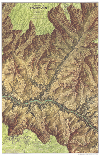
Heart of the Grand Canyon - Published 1978
National Geographic
Compiled from aerial photographs taken in 1972 and field surveying, this map provides striking topography of the canyon and detail of its park facilities, trails, campgrounds, and more. Published in July 1978 as half of a two–map set with "The Grand Canyon of the Colorado", and a companion to two articles on the park.
Page Size: 22.5 x 35 in (568 x 886 mm)
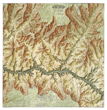
Heart of the Grand Canyon - Published 1999
National Geographic
This map displays the striking topography of the Grand Canyon, while providing details of its park facilities, trails, campgrounds.
Page Size: 35 x 36 in (888 x 913 mm)
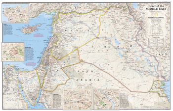
Heart of the Middle East - Published 2002
National Geographic
This attractive political map showing the countries at the heart of the Middle East region also contains inset maps of the cities of Beirut, Jerusalem, Damascus, and Baghdad. Published in October 2002 as half of a two–map set with "Middle East: Crossroads of Faith and Conflict."
Page Size: 31.25 x 20.25 in (791 x 511 mm)
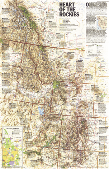
Heart of the Rockies - Published 1995
National Geographic
Stretching more than 3,000 miles from British Columbia in Canada to New Mexico in the United States, the Rocky Mountains attract millions of tourists each year who come for the spectacular scenery and abundant recreational activities. This map of the region features information on dozens of popular sites. Published in July 1995, this map accompanied the "Above the Rockies" physical map which was created using satellite imaging.
Page Size: 20.25 x 31.25 in (513 x 792 mm)
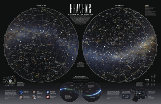
Heavens - Majesty of the Night Sky - Published 2023
National Geographic
Earth's position in a spur of one of the Milky Way's spiraling arms gives us a clear view of the wonders - and enduring mysteries - of deep space. Humans have long marveled at the beauty of the billions of stars above, observing their regular traverse across the sky and seeking to understand their origins and order. Here, a mosaic of thousands of images reveals our celestial sphere in its entirety, and with it, a diversity of multicultural names and imagined patterns amassed over centuries of scholarship and awe.
Page Size: 31.25 x 20.25 in (791 x 511 mm)
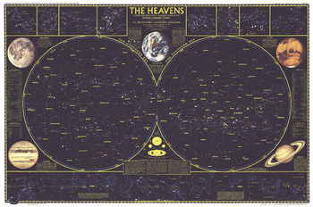
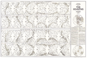
Heavens - Published 1957
National Geographic
Published in December 1957, this map is half of a two-part map of the heavens that appeared with the article "How Man-made Satellites Can Affect Our Lives." It shows the constellations and brightest stars as seen from both the northern and southern hemispheres and also includes information on the planets including their relative size.
Page Size: 42.25 x 28 in (1068 x 711 mm)
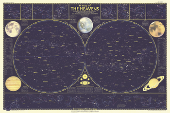
Heavens - Published 1970
National Geographic
Published in August 1970, this map of the heavens shows the constellations and brightest stars as seen from both the northern and southern hemispheres. It also includes information on the planets including their relative size. This map is a wonderful companion to the "Map of the Heavens with Monthly Star Charts for Both Hemispheres" which appeared in the same issue.
Page Size: 34.5 x 22.75 in (871 x 577 mm)
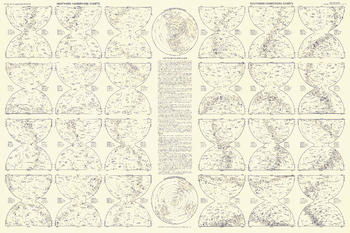
Heavens Star Chart - Published 1957
National Geographic
Explore the heavens from both the northern and southern hemispheres with this detailed star chart. Printed in December 1957 as half of the two-part map of the heavens and with the article "How Man-made Satellites Can Affect Our Lives," this work is a wonderful primer for the amateur astronomer.
Page Size: 42.25 x 28 in (1068 x 711 mm)
Heavens Star Chart - Published 1970
National Geographic
Explore the heavens from both the northern and southern hemispheres with this detailed star chart. Printed in August 1970 as a companion to "The Heavens" map in the same issue, this work is a wonderful primer for the amateur astronomer.
Page Size: 34.5 x 22.75 in (871 x 577 mm)
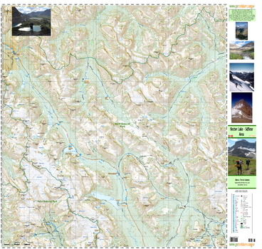
Hector Lake Siffleur Area
GoTrekkers
Hector Lake Siffleur Area
Page Size: 40 x 38 in (1016 x 965 mm)
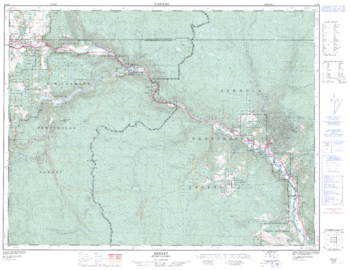
Hedley - 92 H/8 - British Columbia
Natural Resources Canada
Canadian topographic map of Hedley, British Columbia. NTS sheet 092H08 Edition 2.
Page Size: 33 x 25.5 in (833 x 643 mm)
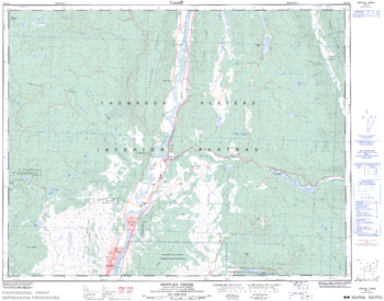
Heffley Creek - 92 I/16 - British Columbia
Natural Resources Canada
Canadian topographic map of Heffley Creek, British Columbia. NTS sheet 092I16 Edition 4.
Page Size: 31.75 x 25 in (804 x 632 mm)
Hema DIY Map
Hema Maps
The most up-to-date street network. Our Hema DIY Map product provides high resolution printed maps with a clean cartographic style suited to urban areas. The road network is highly detailed and updated frequently (map data © 1987-2014 HERE). Custom maps can have a scale from approximately 1:2,000 to 1:5,000,000. Each map contains UTM-based grid lines, projection information, scale bars (in kilometres and miles), geographic extents, data attribution and a land feature symbol Legend.
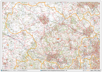
Hemel Hempstead - HP - Postcode Wall Map
XYZ Maps
The Hemel Hempstead Postcode Sector Wall Map shows detailed postcode sector boundaries (HP1 1, HP1 2) on a comprehensive background and is perfect for determining postcode boundaries for sales areas, planning mailshots and also an excellent reference for logistics. This wall map covers the whole of the HP Postcode Area.
Page Size: 47 x 33.25 in (1189 x 841 mm)
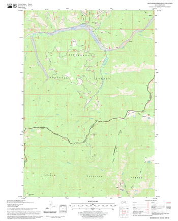
Henderson Ridge Quadrangle, Idaho
United States Department of Agriculture Forest Service
United States Department of Agriculture Forestry Service topographical map of Henderson Ridge, Salmon-Chalis National Forest, Idaho.
Page Size: 21.75 x 27 in (552 x 686 mm)
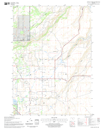
Henkle Butte Quadrangle, Oregon
United States Department of Agriculture Forest Service
United States Department of Agriculture Forestry Service topographical map of Henkle Butte, Deschutes National Forest, Oregon.
Page Size: 21.75 x 27 in (552 x 686 mm)
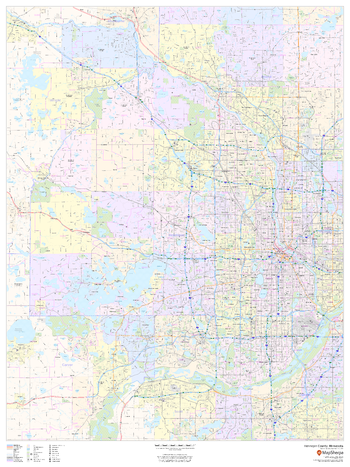
Hennepin County, Minnesota
MapSherpa
This map of Hennepin County, Minnesota shows regional level information. Base map features include highways and major roads with labelling; neighborhood names; railways; high level land use such as parks and recreation areas, industrial areas and hospital campuses; and a selection of points of interest including transportation hubs like airports and train stations, tourist information, police stations and shopping centres. ZIP code boundaries are shown as a secondary map feature.
Page Size: 36 x 48 in (914 x 1219 mm)
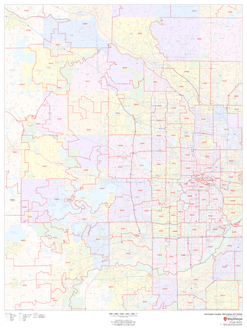
Hennepin County, Minnesota ZIP Codes
MapSherpa
This map of Hennepin County, Minnesota shows ZIP code areas overlaid on a road map. Ideal for planning of deliveries, home services, sales territories, real estate and much more. Base map features include all roads with major roads and highways labelled; neighborhood names; railways; and high level land use such as parks and recreation areas, industrial areas and hospital campuses.
Page Size: 36 x 48 in (914 x 1219 mm)
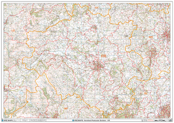
Hereford - HR - Postcode Wall Map
XYZ Maps
The Hereford Postcode Sector Wall Map shows detailed postcode sector boundaries (HR1 1, HR1 2) on a comprehensive background and is perfect for determining postcode boundaries for sales areas, planning mailshots and also an excellent reference for logistics. This wall map covers the whole of the HR Postcode Area.
Page Size: 47 x 33.25 in (1189 x 841 mm)
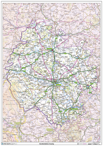
Herefordshire County Map
XYZ Maps
This is a large ceremonial county map of Herefordshire highlighting the county border, with the surrounding area faded out for excellent contrast. The map covers Bromyard, Goodrich, Kington, Ledbury, Leominster, Hereford, Ross-on-Wye and Weobley.The county map shows the latest County and Unitary Authority Boundaries, Overlaid on a Clear and Easy to Read Ordnance Survey map.
Page Size: 33.25 x 47 in (841 x 1189 mm)
No search results