


MapSherpa Catalog
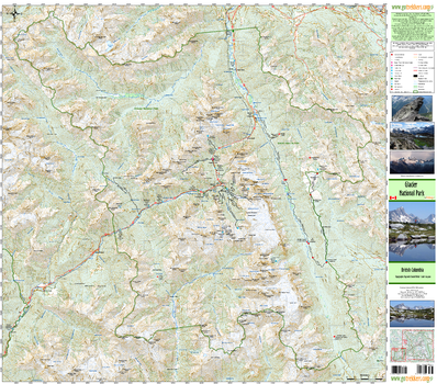
Glacier National Park
GoTrekkers
Glacier National Park
Page Size: 40.5 x 35.5 in (1023 x 899 mm)
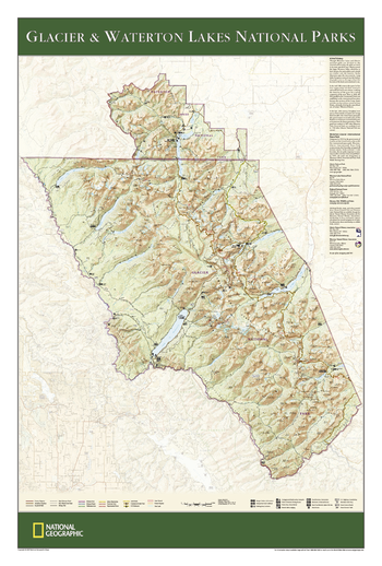
Glacier and Waterton Lakes National Parks
National Geographic
The wall map of Glacier and Waterton Lakes National Parks, based on the popular Trails Illustrated map of the area, provides rich topographic detail to show the Montana and Alberta parks' magnificent scenery, as well as updated trail and road information for the "Crown of the Continent."
Page Size: 24 x 36 in (610 x 914 mm)
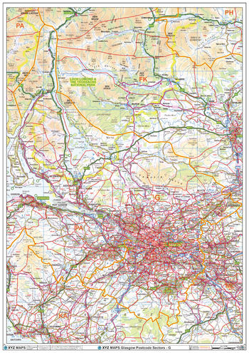
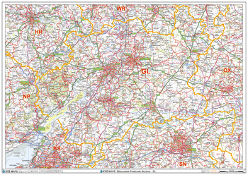
Glasgow - G - Postcode Wall Map
XYZ Maps
The Glasgow Postcode Sector Wall Map shows detailed postcode sector boundaries (G1 1, G1 2) on a comprehensive background and is perfect for determining postcode boundaries for sales areas, planning mailshots and also an excellent reference for logistics. This wall map covers the whole of the G Postcode Area.
Page Size: 33.25 x 47 in (841 x 1189 mm)
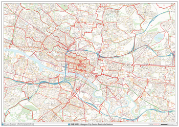
Glasgow City Centre Postcode Sectors Wall Map (C5)
XYZ Maps
The Glasgow City Centre Postcode Sector Wall Map shows detailed postcode sector boundaries along with its associated label (G1 1, G1 2) on a comprehensive background and is perfect for determining postcode boundaries, for sales, logistics, planning mailshots or as a regional reference guide.
Page Size: 47 x 33.25 in (1189 x 841 mm)
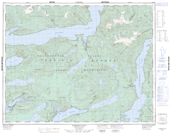
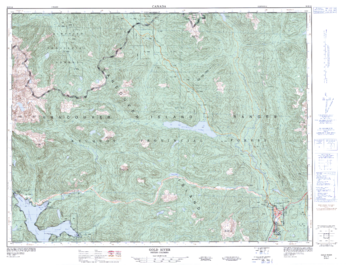
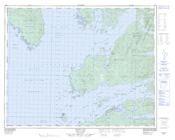
Glendale Cove - 92 K/12 - British Columbia
Natural Resources Canada
Canadian topographic map of Glendale Cove, British Columbia. NTS sheet 092K12 Edition 1.
Page Size: 32.5 x 25.5 in (824 x 644 mm)
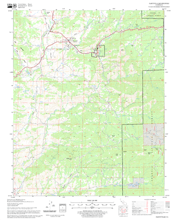
Glennville Quadrangle, California
United States Department of Agriculture Forest Service
United States Department of Agriculture Forestry Service topographical map of Glennville, Sequoia National Forest, California.
Page Size: 21.75 x 27 in (552 x 686 mm)
Global Travel
MapSherpa
Based on OpenStreetMap content; create city or regional scale maps for anywhere in the world. Maps feature a clean design and rich detail designed for the traveller to distant lands. Appropriate for mapping starting at 1:10,000 and up.
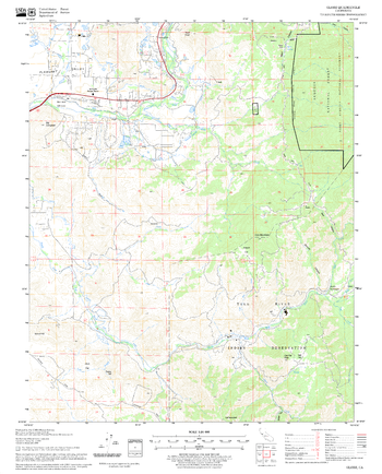
Globe Quadrangle, California
United States Department of Agriculture Forest Service
United States Department of Agriculture Forestry Service topographical map of Globe, Sequoia National Forest, California.
Page Size: 21.75 x 27 in (552 x 686 mm)
Gloucester - GL - Postcode Wall Map
XYZ Maps
The Gloucester Postcode Sector Wall Map shows detailed postcode sector boundaries (GL1 1, GL1 2) on a comprehensive background and is perfect for determining postcode boundaries for sales areas, planning mailshots and also an excellent reference for logistics. This wall map covers the whole of the GL Postcode Area.
Page Size: 47 x 33.25 in (1189 x 841 mm)
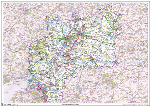
Gloucestershire County Map
XYZ Maps
This is a large ceremonial county map of Gloucestershire highlighting the county border, with the surrounding area faded out for excellent contrast. The map covers Bristol, Cheltenham, Chipping Campden, Cirencester, Lydney, Nailsworth, Stow-on-the-Wold, Stroud and Tewkesbury. The county map shows the latest County and Unitary Authority Boundaries, Overlaid on a Clear and Easy to Read Ordnance Survey map.
Page Size: 47 x 33.25 in (1189 x 841 mm)
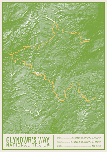
Glyndwr's Way National Trail Map Print
A-Z Maps
This map print highlights the National Trail route of the Glyndwr's Way, showing the start and finish points on an attractive relief base and created in the official National Trail colours.
Page Size: 16.75 x 23.5 in (420 x 594 mm)
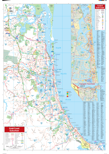
Gold Coast Wall Map
Hema Maps
A map of the Gold Coast and its surrounding regions that features suburbs and postcodes, marked camping areas, caravan parks, fuel supplies, major national parks and an index.
Page Size: 27.75 x 39.5 in (700 x 1000 mm)
Gold Lake Quadrangle, California
United States Department of Agriculture Forest Service
United States Department of Agriculture Forestry Service topographical map of Gold Lake, Tahoe National Forest, California.
Page Size: 21.75 x 27 in (552 x 686 mm)
Gold River - 92 E/16 - British Columbia
Natural Resources Canada
Canadian topographic map of Gold River, British Columbia. NTS sheet 092E16 Edition 2.
Page Size: 33.75 x 25.75 in (854 x 651 mm)
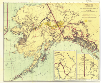
Gold and Coal Fields of Alaska - Published 1898
National Geographic
The Gold and Coal Fields of Alaska map appeared in National Geographic Magazine in April 1898 during the famous Klondike Gold Rush with the article "Alaska and Its Mineral Resources." This work also includes Canada's Klondike region and much of the Yukon Territory. A beautiful historical map and a must-have for collectors.
Page Size: 30.75 x 24.75 in (776 x 628 mm)
Goldstone Pass Quadrangle, Idaho
United States Department of Agriculture Forest Service
United States Department of Agriculture Forestry Service topographical map of Goldstone Pass, Salmon-Chalis National Forest, Idaho.
Page Size: 21.75 x 27 in (552 x 686 mm)
Goodyears Bar Quadrangle, California
United States Department of Agriculture Forest Service
United States Department of Agriculture Forestry Service topographical map of Goodyears Bar, Tahoe National Forest, California.
Page Size: 21.75 x 27 in (552 x 686 mm)
Goose Bay - 92 M/5 - British Columbia
Natural Resources Canada
Canadian topographic map of Goose Bay, British Columbia. NTS sheet 092M05 Edition 2.
Page Size: 32.75 x 26.25 in (831 x 666 mm)
Gooseberry Creek Quadrangle, Idaho
United States Department of Agriculture Forest Service
United States Department of Agriculture Forestry Service topographical map of Gooseberry Creek, Salmon-Chalis National Forest, Idaho.
Page Size: 21.75 x 27 in (552 x 686 mm)
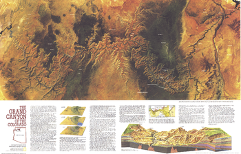
Grand Canyon of Colorado - Published 1978
National Geographic
The Grand Canyon of Colorado map features a striking Landsat satellite image and a cross-section illustrating the geological layers of the canyon. Published in July 1978, this map is half of a two-map set. Its companion is entitled "The Heart of the Grand Canyon" and both maps appeared with two articles on the park.
Page Size: 35 x 22.5 in (887 x 568 mm)
No search results