


MapSherpa Catalog
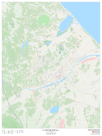
Gangneung 2018 Winter Games Coastal Cluster Venues
MapSherpa
This street map of Gangneung highlights the 6 venues of the 2018 PyeongChang winter games that are in the Gangneung Coastal Cluster: Kwandong Hockey Centre, Gangneung Curling Centre, Gangneung Hockey Centre, Gangneung Ice Arena, Gangneung Oval, and Gangneung Olympic Park.
Page Size: 36 x 48 in (914 x 1219 mm)
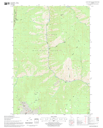
Gant Mountain Quadrangle, Idaho
United States Department of Agriculture Forest Service
United States Department of Agriculture Forestry Service topographical map of Gant Mountain, Salmon-Chalis National Forest, Idaho.
Page Size: 21.75 x 27 in (552 x 686 mm)
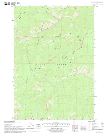
Gant Ridge Quadrangle, Idaho
United States Department of Agriculture Forest Service
United States Department of Agriculture Forestry Service topographical map of Gant Ridge, Salmon-Chalis National Forest, Idaho.
Page Size: 21.75 x 27 in (552 x 686 mm)
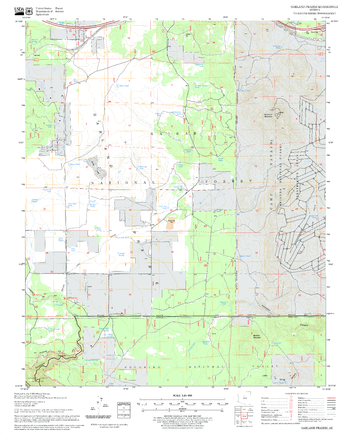
Garland Prairie Quadrangle, Arizona
United States Department of Agriculture Forest Service
United States Department of Agriculture Forestry Service topographical map of Garland Prairie, Coconino National Forest, Arizona.
Page Size: 21.75 x 27 in (552 x 686 mm)
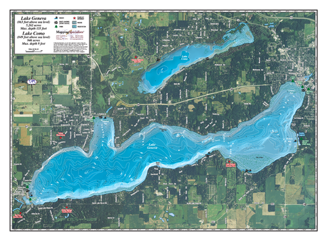
Geneva Lake
Mapping Specialists
An Attractive map of the lake showing a visual 3D representation of the lake bottom. Includes boat launches, rock area and vegetation. Land area is high resolution aerial imagery.
Page Size: 25.25 x 18.75 in (641 x 473 mm)
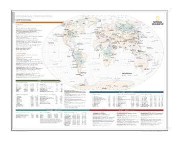
Geographic Comparisons: Earth's Extremes - Atlas of the World, 10th Edition
National Geographic
null
Page Size: 28 x 22 in (711 x 559 mm)
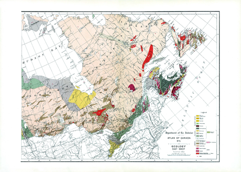
Geology East Sheet (1906)
Natural Resources Canada
Contained within the 1st Edition (1906) of the Atlas of Canada is a map that shows the geology and bedrock for Eastern Canada. The rock type era and period of formation are represented as letter codes and colour, in addition to indicating the surface coverage. The map emphasizes the extensive area in the Dominion that is occupied by the Archaean nucleus. It also includes major cities and railway systems.
Page Size: 24 x 17.25 in (607 x 434 mm)
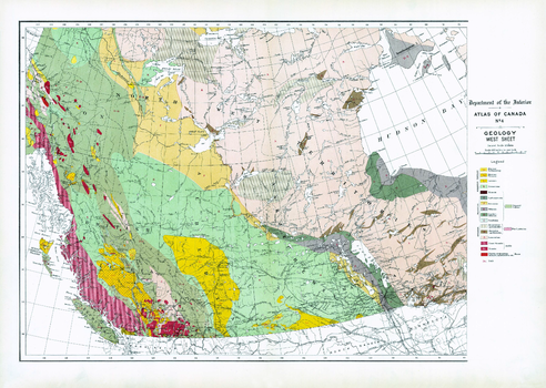
Geology West Sheet (1906)
Natural Resources Canada
Contained within the 1st Edition (1906) of the Atlas of Canada is a map that shows the geology and bedrock for Western Canada. The rock type era and period of formation are represented as letter codes and colour, in addition to indicating the surface coverage. The map emphasizes the extensive area in the Dominion that is occupied by the Archaean nucleus. It also includes major cities and railway systems.
Page Size: 24 x 17.25 in (609 x 433 mm)

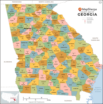
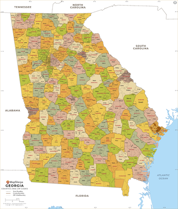
Georgia Counties Map - Extra Large
MapSherpa
This map has been created exclusively for MapSherpa, and designed for reference or business use. Clear and clean colors & fonts matched with cartographic research makes this map of Georgia Counties Map easily readable and useful. The map shows the 159 counties of Georgia and their borders across the Peach State.
Page Size: 60 x 61 in (1524 x 1544 mm)

Georgia Counties Map - Large
MapSherpa
This map has been created exclusively for MapSherpa, and designed for reference or business use. Clear and clean colors & fonts matched with cartographic research makes this map of Georgia Counties Map easily readable and useful. The map shows the 159 counties of Georgia and their borders across the Peach State.
Page Size: 48 x 48.75 in (1219 x 1235 mm)
Georgia Counties Map - Standard
MapSherpa
This map has been created exclusively for MapSherpa, and designed for reference or business use. Clear and clean colors & fonts matched with cartographic research makes this map of Georgia Counties Map easily readable and useful. The map shows the 159 counties of Georgia and their borders across the Peach State.
Page Size: 36 x 36.5 in (914 x 926 mm)
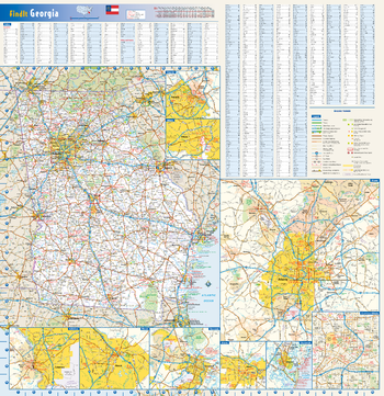
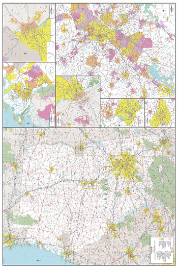
Georgia State Wall Map
Globe Turner
This colorful, easy-to-read state map of Georgia identifies all major thoroughfares, secondary roads, freeway interchanges, rest areas, distance markers, landmarks, recreational areas, and more. Shaded relief on the state map provides a three-dimensional sense of Georgia's topography. Detailed inset maps of Albany, Athens, Atlanta, Augusta, Brunswick, Columbus, Macon, and Savannah are based on the latest street information from our cartographic experts. County and city indices make it simple to locate even the smallest town.
Page Size: 24 x 25 in (610 x 629 mm)
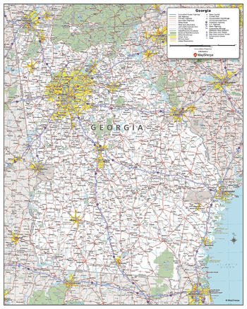
Georgia State Wall Map - Compact
MapSherpa
This detailed wall map of Georgia is perfect for both educational and business purposes. The easy-to-read map features vibrant colors and clear labeling of cities, counties, highways, and geographical features. All national and state highways that connect the state are all clearly labelled on the map, while the legend notes the different road and land use classifications such as urban, park, military, and many more. The boundaries of each county in the state are defined and named clearly. Whether you are a student, teacher, business person or geography enthusiast, this map is a valuable addition to any space.
Page Size: 16 x 20 in (406 x 508 mm)
Georgia State Wall Map - Extra Large
MapSherpa
This detailed wall map of Georgia is perfect for both educational and business purposes. The easy-to-read map features vibrant colors and clear labeling of cities, counties, highways, and geographical features. All national and state highways that connect the state are all clearly labelled on the map, while the legend notes the different road and land use classifications such as urban, park, military, and many more. The boundaries of each county in the state are defined and named clearly. Whether you are a student, teacher, business person or geography enthusiast, this map is a valuable addition to any space.
Page Size: 40 x 60 in (1016 x 1524 mm)
Georgia State Wall Map - Large
MapSherpa
This detailed wall map of Georgia is perfect for both educational and business purposes. The easy-to-read map features vibrant colors and clear labeling of cities, counties, highways, and geographical features. All national and state highways that connect the state are all clearly labelled on the map, while the legend notes the different road and land use classifications such as urban, park, military, and many more. The boundaries of each county in the state are defined and named clearly. Whether you are a student, teacher, business person or geography enthusiast, this map is a valuable addition to any space.
Page Size: 32 x 48 in (813 x 1219 mm)
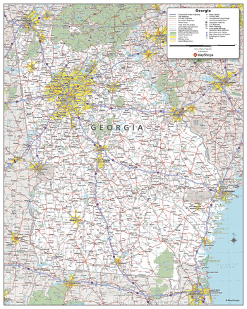
Georgia State Wall Map - Poster
MapSherpa
This detailed wall map of Georgia is perfect for both educational and business purposes. The easy-to-read map features vibrant colors and clear labeling of cities, counties, highways, and geographical features. All national and state highways that connect the state are all clearly labelled on the map, while the legend notes the different road and land use classifications such as urban, park, military, and many more. The boundaries of each county in the state are defined and named clearly. Whether you are a student, teacher, business person or geography enthusiast, this map is a valuable addition to any space.
Page Size: 24 x 30 in (610 x 762 mm)
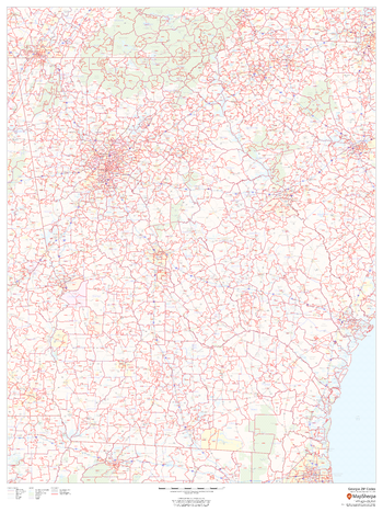
Georgia ZIP Code Map
MapSherpa
This map of Georgia shows ZIP codes overlaid on a road map. Base map features include municipality and county boundaries, major road network features, and state and national parks and conservation areas.
Page Size: 36 x 48 in (914 x 1219 mm)
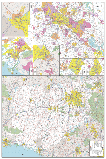
Georgia ZIP Code Map with Counties - Extra Large
MapSherpa
This map has been created exclusively for MapSherpa, and designed for business or reference use. Clear and clean colors & fonts matched with cartographic research makes this Georgia Zip Code Map with Counties easily readable and useful. The map shows the 159 counties of Georgia and the borders of the over 700 zip codes across the Peach State.
Page Size: 60 x 70.5 in (1524 x 1789 mm)
Georgia ZIP Code Map with Counties - Large
MapSherpa
This map has been created exclusively for MapSherpa, and designed for business or reference use. Clear and clean colors & fonts matched with cartographic research makes this Georgia Zip Code Map with Counties easily readable and useful. The map shows the 159 counties of Georgia and the borders of the over 700 zip codes across the Peach State.
Page Size: 48 x 56.5 in (1219 x 1431 mm)

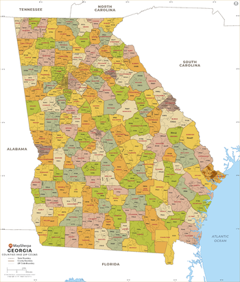
Georgia ZIP Code Map with Counties - Standard
MapSherpa
This map has been created exclusively for MapSherpa, and designed for business or reference use. Clear and clean colors & fonts matched with cartographic research makes this Georgia Zip Code Map with Counties easily readable and useful. The map shows the 159 counties of Georgia and the borders of the over 700 zip codes across the Peach State.
Page Size: 36 x 42.25 in (914 x 1073 mm)
No search results