


MapSherpa Catalog
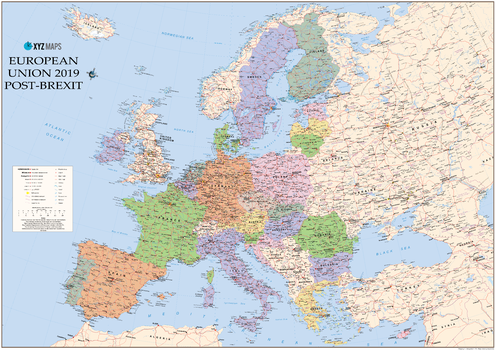
European Union 2019 Post Brexit Wall Map
XYZ Maps
The European Union 2019 Post-Brexit Political wall map is ideal for the office or educational environment. This unique EU map features political colouring showing Europe and the member countries of the European Union. All major Towns, Roads, Rivers and Lakes are shown on this map. This map shows the British Isles as they will appear once the UK has completed leaving the EU!
Page Size: 47 x 33.25 in (1189 x 841 mm)
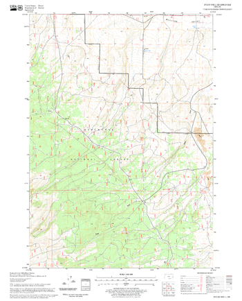
Evans Well Quadrangle, Oregon
United States Department of Agriculture Forest Service
United States Department of Agriculture Forestry Service topographical map of Evans Well, Deschutes National Forest, Oregon.
Page Size: 21.75 x 27 in (552 x 686 mm)
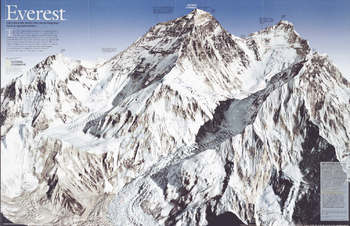
Everest - Published 2003
National Geographic
In the old days mapping required thousands of measurements by hand with theodolite and transit. This striking map of Mount Everest, created a half century after the first climb, was built on millions of measurements, but none made by hand. The space shuttle recorded infrared images for reference; then a jet aircraft took stereophotographs, which were converted to digital data and merged by computer to create the sharpest, most accurate image yet of the great mountain. Published in May 2003, this map was half of a two-piece set with "Everest 50."
Page Size: 21 x 13.5 in (528 x 342 mm)
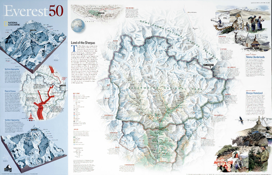
Everest 50 - Published 2003
National Geographic
A half century after the first climb, National Geographic produced this stunning map of Mount Everest and the surrounding region including Sagarmatha National Park, Qomolangma National Nature Reserve, and Makalu-Barun National Park. Published in May 2003 as half of a two-piece set with a poster map of Mount Everest, this map's focus is on the challenges facing the governments of Tibet and Nepal as they work to protect their environment. A surge of visitors in recent decades has raised alarms about the fate of the region's landscape and people. Both have proven to be resilient enough, so far, to withstand the crush of their popularity.
Page Size: 21.5 x 14 in (543 x 350 mm)
Executive Antarctica Political
Maps International
Splendid premium map of Antarctica in muted tones. Our Executive Antarctica map shows territory divisions, the major expedition routes, camps and weather stations. The map features hill shading.
Executive Asia Political
Maps International
Splendid map of the Asia in muted tones. This Asia map features countries marked in a different colour, with international boundaries shown.
Executive Australasia Political
Maps International
Splendid map of the Australasia in muted tones. This Australasia map features countries marked in a different colour, with international boundaries shown.
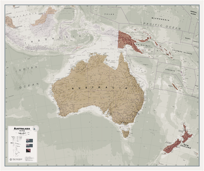
Executive Australasia Political Wall Map
Maps International
Splendid map of the Australasia in muted tones. This Australasia map features countries marked in a different colour, with international boundaries shown.
Page Size: 47.5 x 39.75 in (1203 x 1007 mm)
Executive Canada Political
Maps International
Splendid map of the Canada in muted tones. This Canada map clearly depicts all the cities, major roads and also shows all the Provinces and Territory boundaries. All major cities and areas are displayed bi-lingually.
Executive Canada Political Wallpaper
Maps International
Splendid premium map of Canada in muted tones. It clearly depicts all the cities, major roads and also shows all the Provinces and Territory boundaries. All major cities and areas are displayed bi-lingually.
Executive Europe Political
Maps International
Splendid map of the Europe in muted tones. This European map features countries marked in a different colour, with international boundaries shown.
Executive Europe Political Wallpaper
Maps International
Splendid premium map of the Europe in muted tones. Political detail (countries shaded in different tones), country boundaries and cities are shown. The map also contains hill and sea shading.
Executive North America Political
Maps International
Splendid map of the North America in muted tones. This North America map features countries marked in a different colour, with international boundaries shown.
Executive South America Political
Maps International
Splendid map of the South America in muted tones. This South America map features countries marked in a different colour, with international boundaries shown.
Executive USA Political
Maps International
Splendid map of the USA in muted tones. This USA map clearly depicts all the cities, major roads and also shows all the state areas and boundaries.
Executive USA Political Wallpaper
Maps International
Splendid premium map of the USA in muted tones. It clearly depicts all the cities, major roads and also shows all the state areas and boundaries
Executive World Political Wallpaper
Maps International
Splendid premium map of the world in muted tones. Political detail (countries shaded in different tones), country boundaries and cities are shown.
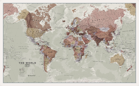
Executive World Wall Map
Maps International
A popular executive world wall map. With its artistic antique-style muted tones, it looks simply stunning and rather elegant. Map Detail: This executive world wall map is complete with political detail (countries shaded in different tones), country boundaries and cities shown.
Page Size: 53.75 x 33.25 in (1360 x 840 mm)

Exeter - EX - Postcode Wall Map
XYZ Maps
The Exeter Postcode Sector Wall Map shows detailed postcode sector boundaries (EX1 1, EX1 2) on a comprehensive background and is perfect for determining postcode boundaries for sales areas, planning mailshots and also an excellent reference for logistics. This wall map covers the whole of the EX Postcode Area.
Page Size: 47 x 33.25 in (1189 x 841 mm)
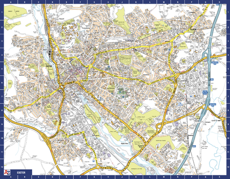
Exeter A-Z Street Map
A-Z Maps
The perfect reference map for finding your way around Exeter. This up-to-date detailed A-Z town plan includes over 2,100 streets in and around Exeter. As well as the central area of the University colleges and Cathedral, the other areas covered are Larkbeare, Friars Green, Barnfield, St Thomas and St David’s. The highly detailed 1 mile to 5.5 inch street map includes places of interest, among other features.
Page Size: 28.5 x 22.25 in (718 x 560 mm)
No search results