


MapSherpa Catalog
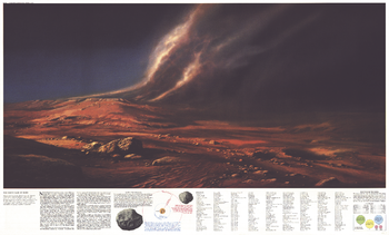
Dusty Face of Mars - Published 1973
National Geographic
This map contains the complete index for "The Red Planet Mars" map, published in February 1973 along with two articles on the planet: "Journey to Mars" and "The Search for Life on Mars." In addition to the index, this map features a breathtaking illustration of martian landscape and information on the satellites of Mars.
Page Size: 38 x 23 in (962 x 580 mm)
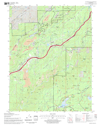
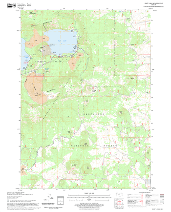
Dutch Flat Quadrangle, California
United States Department of Agriculture Forest Service
United States Department of Agriculture Forestry Service topographical map of Dutch Flat, Tahoe National Forest, California.
Page Size: 21.75 x 27 in (552 x 686 mm)
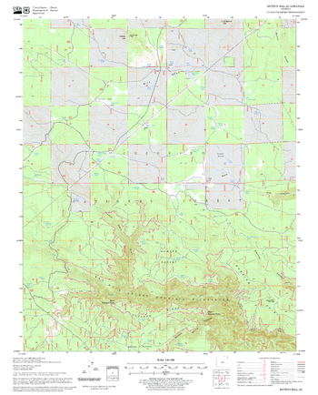
Dutton Hill Quadrangle, Arizona
United States Department of Agriculture Forest Service
United States Department of Agriculture Forestry Service topographical map of Dutton Hill, Coconino National Forest, Arizona.
Page Size: 21.75 x 27 in (552 x 686 mm)
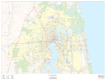
Duval County, Florida
MapSherpa
This map of Duval County, Florida shows regional level information. Base map features include highways and major roads with labelling; neighborhood names; railways; high level land use such as parks and recreation areas, industrial areas and hospital campuses; and a selection of points of interest including transportation hubs like airports and train stations, tourist information, police stations and shopping centres. ZIP code boundaries are shown as a secondary map feature.
Page Size: 48 x 36 in (1219 x 914 mm)
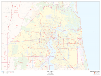
Duval County, Florida ZIP Codes
MapSherpa
This map of Duval County, Florida shows ZIP code areas overlaid on a road map. Ideal for planning of deliveries, home ervices, sales territories, real estate and much more. Base map features include all roads with major roads and highways labelled; neighborhood names; railways; and high level land use such as parks and recreation areas, industrial areas and hospital campuses.
Page Size: 48 x 36 in (1219 x 914 mm)
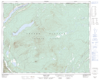
Eagle Eye - 92 N/16 - British Columbia
Natural Resources Canada
Canadian topographic map of Eagle Eye, British Columbia. NTS sheet 092N16 Edition 2.
Page Size: 31.75 x 25.5 in (804 x 643 mm)
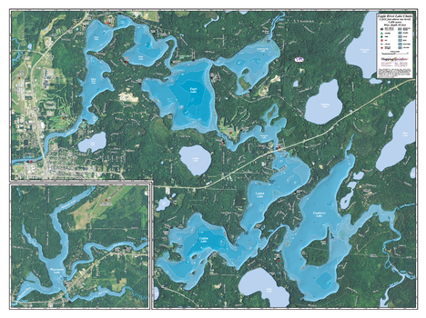
Eagle River Chain
Mapping Specialists
An Attractive map of the lake showing a visual 3D representation of the lake bottom. Includes boat launches, rock area and vegetation. Land area is high resolution aerial imagery.
Page Size: 37.25 x 27.75 in (943 x 705 mm)
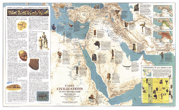
Early Civilizations in the Middle East - Published 1978
National Geographic
This fascinating map features a thorough overview of the history of the Middle East region and the civilizations who called it home. Includes illustrations of artifacts. Published in September 1978 as a companion to the "Middle East" political map.
Page Size: 37 x 22.75 in (937 x 578 mm)

Earth From Space - Published 1973
National Geographic
Astronaut Harrison H. Schmitt captured this image from 25,000 miles above the Earth aboard Apollo 17 in December, 1972. This classic map accompanied four articles on Space exploration. The perfect complement to our "Teammates in Mankind's Greatest Adventure" poster.
Page Size: 34 x 22.5 in (860 x 568 mm)
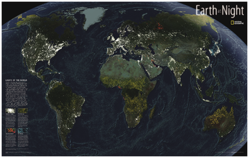
Earth at Night
National Geographic
This intriguing map reveals in stunning detail the pulsating lights of the Earth at night. See where populations are most and least concentrated. The rare view is a composite image made by three satellites on cloud-free nights over a one-year period. In addition to showing lighted areas of the Earth, this map also features where fires rage and natural gas burn-off and night fishing locations.
Page Size: 35.25 x 22.25 in (891 x 564 mm)
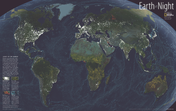
Earth at Night - Published 2004
National Geographic
While the Earth sleeps, lights pulsates across its surface in a lively dance visible from the vantage of space. This magnificent composite of satellite images from cloud-free nights gathered over a one year period. One look reveals the obvious: Rich, developed regions like the United States, Europe, and Japan glow with gaudy abandon, using energy disproportionate to their populations. Over the next few decades, many scientists expect a growth of lights in developing countries. But some anticipate seeing fewer lights in the wealthiest nations, where advances in lighting technology could save energy and better contain light emissions. Published in November 2004, this map represents half of a two-map set with a political map of the world.
Page Size: 35.25 x 22.25 in (890 x 562 mm)
Earth's Moon
National Geographic
This National Geographic classic shows the mystery of bird migration and the incredible journeys that birds undertake in the Americas each year. 67 types of birds that migrate are shown on a map of the Americas that is overlaid with pathways that show migration routes from nesting grounds to wintering areas. Full-color bird paintings by noted illustrator Arthur Singer show each of the 67 species, making it easy to identify birds as they fly their amazing journeys.
Page Size: 43.25 x 29.25 in (1094 x 739 mm)
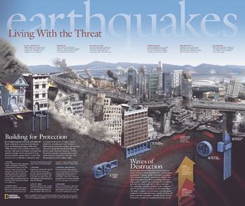
Earthquakes, Living With the Threat - Published 2006
National Geographic
Published in April 2006 as half of a two-piece set with "Danger Zones: Earthquake Risk, A Global View," this remarkable poster demonstrates the damage done to buildings, highways, high-rises, and other structures within a city when plates shift. It also reveals how strict construction standards and new innovations help hold things together when earthquakes strike.
Page Size: 24 x 20.25 in (609 x 512 mm)
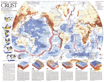
Earths Dynamic Crust - Published 1985
National Geographic
Explore the forces behind the shaping of our planet. This fascinating map explains the various forms of tectonic activity such as hot spots, accretion, subduction, and spreading. It also shows the locations of volcanoes and earthquakes of 6.0 magnitude or greater that occurred during 1975-1985. Published in August 1985 as half of a two–map set with "The Shaping of a Continent: North America's Active West", and as a companion to the article "Our Restless Planet Earth."
Page Size: 22.75 x 18 in (575 x 454 mm)
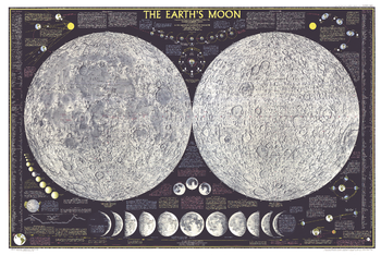
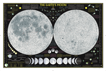
Earths Moon - Published 1969
National Geographic
Explore the moon in striking detail with this educational map published in February 1969. Featuring detailed illustrations of both the near and far sides of the moon, this map also contains an abundance of illustrations and information about the moon including its physical properties and features, phases, eclipses, orbital paths, and the Apollo mission.
Page Size: 42 x 28 in (1065 x 711 mm)
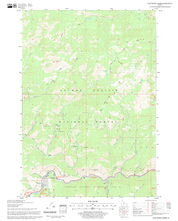
East Basin Creek Quadrangle, Idaho
United States Department of Agriculture Forest Service
United States Department of Agriculture Forestry Service topographical map of East Basin Creek, Salmon-Chalis National Forest, Idaho.
Page Size: 21.75 x 27 in (552 x 686 mm)

East City London - EC - Postcode Wall Map
XYZ Maps
The East City London Postcode Sector Wall Map shows detailed postcode sector boundaries (EC1 1, EC1 2) on a comprehensive background and is perfect for determining postcode boundaries for sales areas, planning mailshots and also an excellent reference for logistics. This wall map covers the whole of the EC Postcode Area.
Page Size: 47 x 33.25 in (1189 x 841 mm)
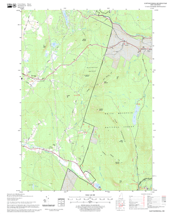
East Haverhill Quadrangle, New Hampshire-Vermont
United States Department of Agriculture Forest Service
United States Forestry Service topographical map of East Haverhill, New Hampshire-Vermont
Page Size: 21.75 x 27 in (552 x 686 mm)
East Lake Quadrangle, Oregon
United States Department of Agriculture Forest Service
United States Department of Agriculture Forestry Service topographical map of East Lake, Deschutes National Forest, Oregon.
Page Size: 21.75 x 27 in (552 x 686 mm)

East London - E - Postcode Wall Map
XYZ Maps
The East London Postcode Sector Wall Map shows detailed postcode sector boundaries (E1 1, E1 2) on a comprehensive background and is perfect for determining postcode boundaries for sales areas, planning mailshots and also an excellent reference for logistics. This wall map covers the whole of the E Postcode Area.
Page Size: 33.25 x 47 in (841 x 1189 mm)
No search results