


MapSherpa Catalog

D-Day - Omaha Beach - Normandy - Wall Map
XYZ Maps
A D-Day map covering Charlie, Dog, Easy and Fox sectors of Omaha Beach and the towns of Vierville-sur-Mer, les Moulins and Colleville-sur-Mer. Includes Information up until April 6th, 1944, just 2 months to the day before the landings started. The Original Maps have been digitally scanned at high resolution in Full Colour.
Page Size: 30 x 23.25 in (762 x 590 mm)

D-Day - Ste. Marie du Mont - Normandy - Wall Map
XYZ Maps
D-Day map dated 19 May, 1944. Covering the area between Utah and Omaha Beaches and the Town of Sainte. Marie du Mont. This Map was produced in the run up to D-Day by the Allies, as they planned the assault on Normandy. The Original Maps have been digitally scanned at high resolution in Full Colour.
Page Size: 28.25 x 21 in (717 x 533 mm)
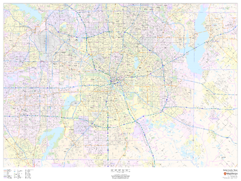
Dallas - Fort Worth, Texas ZIP Codes
MapSherpa
This map of Dallas - Fort Worth shows ZIP code areas overlaid on a road map. Ideal for planning of deliveries, home services, sales territories, real estate and much more. Base map features include all roads with major roads and highways labelled; neighborhood names; railways; and high level land use such as parks and recreation areas, industrial areas and hospital campuses.
Page Size: 48 x 36 in (1219 x 914 mm)
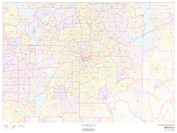
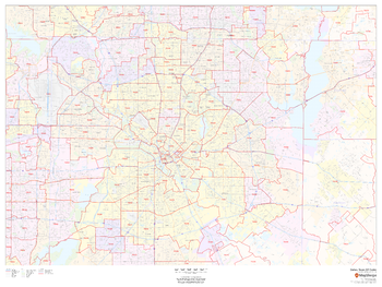
Dallas County, Texas
MapSherpa
This map of Dallas County, Texas shows regional level information. Base map features include highways and major roads with labelling; neighborhood names; railways; high level land use such as parks and recreation areas, industrial areas and hospital campuses; and a selection of points of interest including transportation hubs like airports and train stations, tourist information, police stations and shopping centres. ZIP code boundaries are shown as a secondary map feature.
Page Size: 48 x 36 in (1219 x 914 mm)
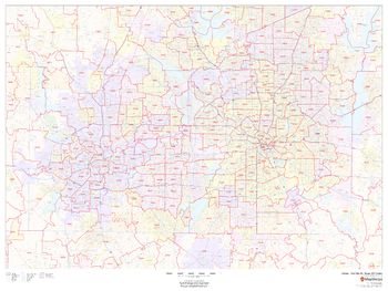
Dallas County, Texas ZIP Codes
MapSherpa
This map of Dallas County, Texas shows ZIP code areas overlaid on a road map. Ideal for planning of deliveries, home services, sales territories, real estate and much more. Base map features include all roads with major roads and highways labelled; neighborhood names; railways; and high level land use such as parks and recreation areas, industrial areas and hospital campuses.
Page Size: 48 x 36 in (1219 x 914 mm)
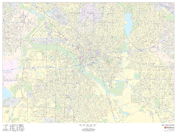
Dallas, Texas Inner Metro - Landscape
MapSherpa
This landscape-oriented map of central Dallas, Texas shows detailed street level information including extensive street labeling. Ideal for planning of deliveries, home services, sales territories, real estate and much more. Base map features include all roads with major roads and highways labelled; neighborhood names; railways; high level land use such as parks and recreation areas, industrial areas and hospital campuses; and a variety of points of interest including schools, libraries, stadiums, museums, border crossings and more.
Page Size: 48 x 36 in (1219 x 914 mm)
Dallas, Texas Inner Metro - Portrait
MapSherpa
This portrait-oriented map of central Dallas, Texas shows detailed street level information including extensive street labeling. Ideal for planning of deliveries, home services, sales territories, real estate and much more. Base map features include all roads with major roads and highways labelled; neighborhood names; railways; high level land use such as parks and recreation areas, industrial areas and hospital campuses; and a variety of points of interest including schools, libraries, stadiums, museums, border crossings and more.
Page Size: 36 x 48 in (914 x 1219 mm)
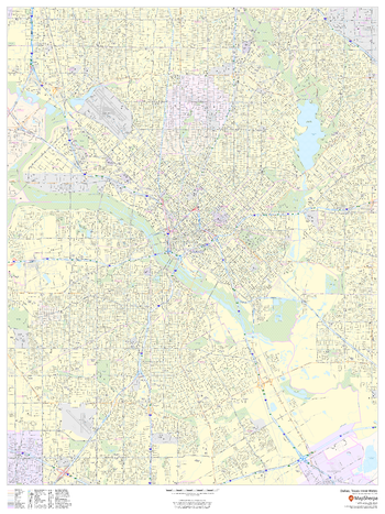
Dallas, Texas ZIP Codes
MapSherpa
This map of Dallas shows ZIP code areas overlaid on a road map. Ideal for planning of deliveries, home services, sales territories, real estate and much more. Base map features include all roads with major roads and highways labelled; neighborhood names; railways; and high level land use such as parks and recreation areas, industrial areas and hospital campuses.
Page Size: 48 x 36 in (1219 x 914 mm)
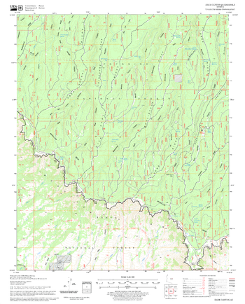
Dane Canyon Quadrangle, Arizona
United States Department of Agriculture Forest Service
United States Department of Agriculture Forestry Service topographical map of Dane Canyon, Coconino National Forest, Arizona.
Page Size: 21.75 x 27 in (552 x 686 mm)
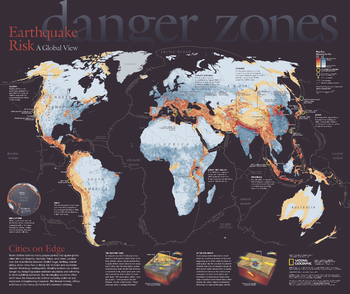
Danger Zones, Earthquake Risk, a Global View - Published 2006
National Geographic
Never before have so many people packed into earthquake-prone cities like Los Angeles, Istanbul, Tokyo, and Lima. Located near the boundaries between Earth's huge, shifting crustal plates, these cities face a rising risk of death and economic disaster from large earthquakes. This eye-catching map reveals the areas most at risk and their populations. Published in April 2006, this map was half of a two-piece set with
Page Size: 24 x 20.25 in (610 x 512 mm)

Darlington - DL - Postcode Wall Map
XYZ Maps
The Darlington Postcode Sector Wall Map shows detailed postcode sector boundaries (DL1 1, DL1 2) on a comprehensive background and is perfect for determining postcode boundaries for sales areas, planning mailshots and also an excellent reference for logistics. This wall map covers the whole of the DL Postcode Area.
Page Size: 47 x 33.25 in (1189 x 841 mm)

Dartford - DA - Postcode Wall Map
XYZ Maps
The Dartford Postcode Sector Wall Map shows detailed postcode sector boundaries (DA1 1, DA1 2) on a comprehensive background and is perfect for determining postcode boundaries for sales areas, planning mailshots and also an excellent reference for logistics. This wall map covers the whole of the DA Postcode Area.
Page Size: 47 x 33.25 in (1189 x 841 mm)
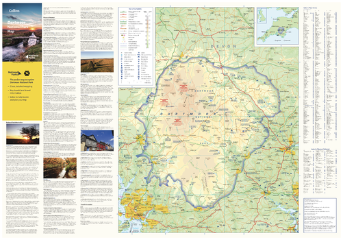
Dartmoor National Park Map
Collins
With clear mapping and a high level of detail, explore Dartmoor National Park easily with maps from Collins. This map identifies key park, tourist, and travel information, presented alongside a selection of photographs, making it an ideal companion for those exploring this beautiful area of Southern England.
Page Size: 32 x 22.25 in (810 x 560 mm)
Dave Lewis Peak Quadrangle, Idaho
United States Department of Agriculture Forest Service
United States Department of Agriculture Forestry Service topographical map of Dave Lewis Peak, Salmon-Chalis National Forest, Idaho.
Page Size: 21.75 x 27 in (552 x 686 mm)
Davis Mountain Quadrangle, Oregon
United States Department of Agriculture Forest Service
United States Department of Agriculture Forestry Service topographical map of Davis Mountain, Deschutes National Forest, Oregon.
Page Size: 21.75 x 27 in (552 x 686 mm)
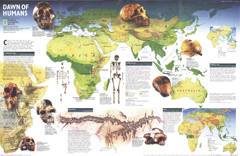
Dawn of Humans - Published 1997
National Geographic
This fascinating map contains a wealth of information on our quest to discover the history of our prehistoric ancestors including fossil sites, information on significant hominid finds, and the challenges researchers face. Published in February 1997 with the "Seeking Our Origins" companion map, this work also includes maps which show the vegetation zones 125,000 years ago, 65,000 years ago, and today.
Page Size: 31.25 x 20.25 in (790 x 513 mm)
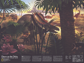
Dawn on the Delta - Published 1993
National Geographic
Published in January 1993, the "Dawn on the Delta: 74 Million Years Ago" poster is a stunning illustration of dinosaurs indiginous to North America. A companion to the "North America in the Age of the Dinosaurs" map, this beautiful depiction of an ancient landscape is a must-have for those fascinated by these enigmatic creatures.
Page Size: 27 x 20.25 in (683 x 513 mm)
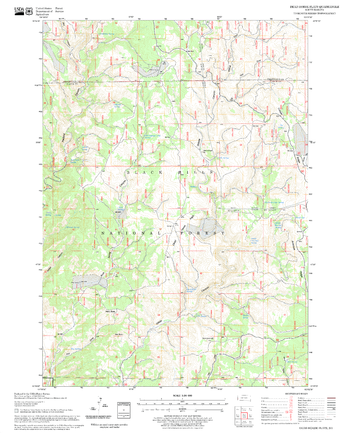
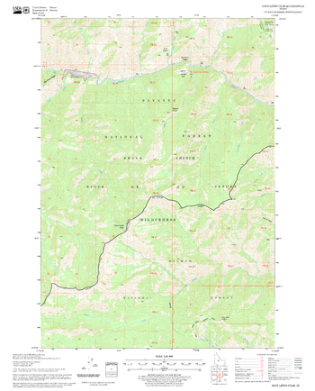
Dead Horse Flats Quadrangle, South Dakota
United States Department of Agriculture Forest Service
United States Department of Agriculture Forestry Service topographical map of Dead Horse Flats, Black Hills National Forest, South Dakota.
Page Size: 21.75 x 27 in (552 x 686 mm)
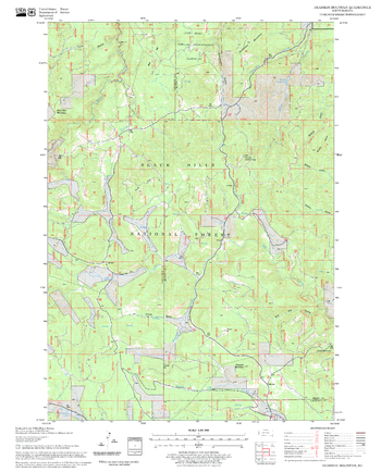
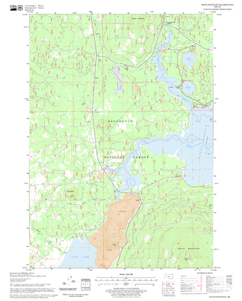
Deadman Mountain Quadrangle, South Dakota
United States Department of Agriculture Forest Service
United States Department of Agriculture Forestry Service topographical map of Deadman Mountain, Black Hills National Forest, South Dakota.
Page Size: 21.75 x 27 in (552 x 686 mm)
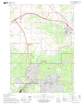
Deadwood North Quadrangle, South Dakota
United States Department of Agriculture Forest Service
United States Department of Agriculture Forestry Service topographical map of Deadwood North, Black Hills National Forest, South Dakota.
Page Size: 21.75 x 27 in (552 x 686 mm)
No search results