


MapSherpa Catalog
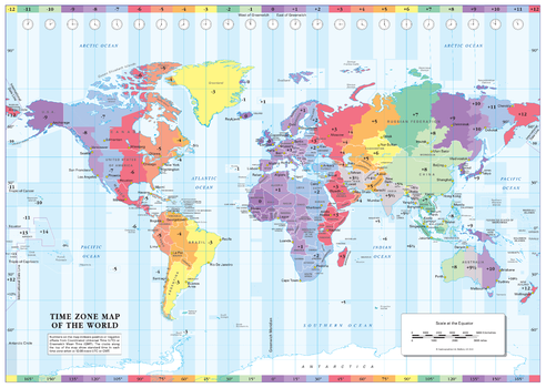
Colour Blind Friendly Time Zone Wall Map of the World - Small
Cosmographics
A great reference to the world's time zones. A colourful, easy to read map showing the the time zones and country borders, naming most countries and a selection of cities around the world. Designed especially to work with any form of colour blindness this map is ideal for the classroom or office, as well as for the home. There is likely to be at least one child in every classroom that is colour blind.
Page Size: 22.25 x 15.75 in (562 x 400 mm)
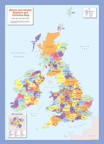
Colour blind friendly Counties Wall Map of the British Isles
Cosmographics
There is likely to be at least one child in every classroom that is colour blind. Designed especially to work with any form of colour blindness, this colourful, easy to read children's map of the United Kingdom showing counties and a selection of cities and main towns is ideal for the classroom.
Page Size: 25.25 x 36 in (640 x 910 mm)
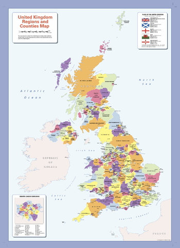
Colour blind friendly Counties Wall Map of the United Kingdom
Cosmographics
There is likely to be at least one child in every classroom that is colour blind. Designed especially to work with any form of colour blindness, this colourful, easy to read children's map of the United Kingdom showing counties and a selection of cities and main towns is ideal for the classroom.
Page Size: 25.25 x 36 in (640 x 910 mm)
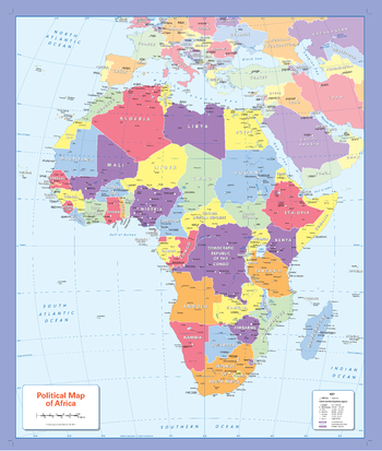
Colour blind friendly Political Wall Map of Africa
Cosmographics
There is likely to be at least one child in every classroom that is colour blind. Designed especially to work with any form of colour blindness, this colourful, easy to read children's map of Africa showing countries, capitals and a selection of cities and main towns is ideal for the classroom.
Page Size: 26.5 x 31.75 in (668 x 805 mm)

Colour blind friendly Political Wall Map of Asia
Cosmographics
There is likely to be at least one child in every classroom that is colour blind. Designed especially to work with any form of colour blindness, this colourful, easy to read children's map of Asia showing countries, capitals and a selection of cities and main towns is ideal for the classroom.
Page Size: 31.75 x 26.5 in (804 x 668 mm)
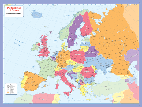
Colour blind friendly Political Wall Map of Europe
Cosmographics
There is likely to be at least one child in every classroom that is colour blind. Designed especially to work with any form of colour blindness, this colourful, easy to read children's map of Europe showing countries, capitals and a selection of cities and main towns is ideal for the classroom.
Page Size: 35.75 x 26.5 in (905 x 668 mm)
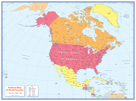
Colour blind friendly Political Wall Map of North America
Cosmographics
There is likely to be at least one child in every classroom that is colour blind. Designed especially to work with any form of colour blindness, this colourful, easy to read children's map of North America showing countries, states, capitals and a selection of cities and main towns is ideal for the classroom.
Page Size: 35.75 x 26.5 in (905 x 668 mm)
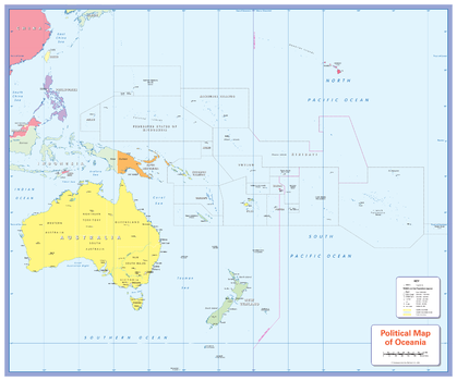
Colour blind friendly Political Wall Map of Oceania
Cosmographics
There is likely to be at least one child in every classroom that is colour blind. Designed especially to work with any form of colour blindness, this colourful, easy to read children's map of Oceania showing countries, Pacific Islands capitals and a selection of cities and main towns is ideal for the classroom.
Page Size: 31.75 x 26.5 in (805 x 668 mm)
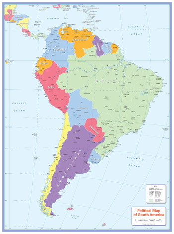
Colour blind friendly Political Wall Map of South America
Cosmographics
There is likely to be at least one child in every classroom that is colour blind. Designed especially to work with any form of colour blindness, this colourful, easy to read children's map of South America showing countries, the provinces of Brazil, capitals and a selection of cities and main towns is ideal for the classroom.
Page Size: 26.5 x 35.75 in (668 x 905 mm)
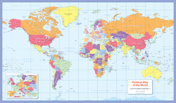
Colour blind friendly Political Wall Map of the World
Cosmographics
There is likely to be at least one child in every classroom that is colour blind. Designed especially to work with any form of colour blindness, this colourful, easy to read children's map of the World showing the countries and their capitals is ideal for the classroom.
Page Size: 40.25 x 23.5 in (1020 x 595 mm)
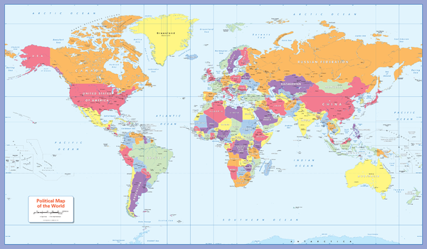
Colour blind friendly Political Wall Map of the World - Large
Cosmographics
There is likely to be at least one child in every classroom that is colour blind. Designed especially to work with any form of colour blindness, this colourful, easy to read children's map of the World showing the countries and their capitals is ideal for the classroom.
Page Size: 53.5 x 31.25 in (1355 x 790 mm)
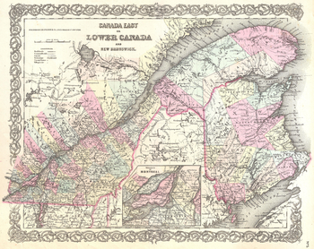
Colton Map of Canada East or Quebec (1855)
Artokoloro
1855 map of southern Quebec (Lower Canada) and New Brunswick published by American mapmakers J.H Colton & Co. Full title: Canada East or Lower Canda and New Brunswick.
Page Size: 18 x 14.25 in (454 x 360 mm)
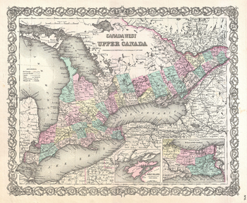
Colton Map of Upper Canada or Ontario (1855)
Artokoloro
1855 map of southern Ontario (Upper Canada) published by American mapmakers J.H Colton & Co. Full title: Canada West or Upper Canada.
Page Size: 18 x 14.75 in (454 x 373 mm)
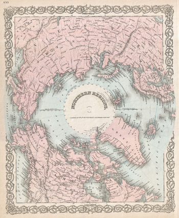
Colton Map of the North Pole or Arctic (1872)
Artokoloro
1872 map centered on the North Pole by American mapmakers G.W and C.B Colton & Co. Full title: Northern Regions.
Page Size: 14.5 x 17.75 in (367 x 448 mm)
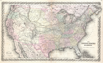
Colton Map of the United States (1855)
Artokoloro
1855 map of the United States published by American mapmakers J.H Colton & Co. Full title: The United States of America.
Page Size: 23 x 14 in (579 x 353 mm)
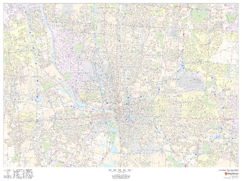
Columbus, Ohio Inner Metro - Landscape
MapSherpa
This landscape-oriented map of central Columbus, Ohio shows detailed street level information including extensive street labeling. Ideal for planning of deliveries, home services, sales territories, real estate and much more. Base map features include all roads with major roads and highways labelled; neighborhood names; railways; high level land use such as parks and recreation areas, industrial areas and hospital campuses; and a variety of points of interest including schools, libraries, stadiums, museums, border crossings and more.
Page Size: 48 x 36 in (1219 x 914 mm)
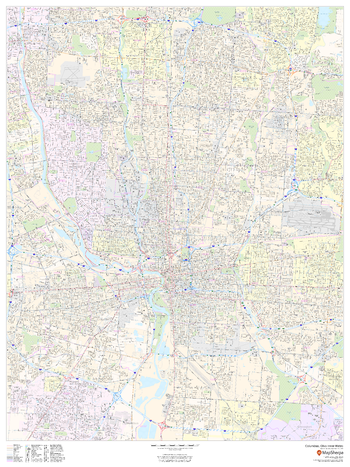
Columbus, Ohio Inner Metro - Portrait
MapSherpa
This portrait-oriented map of central Columbus, Ohio shows detailed street level information including extensive street labeling. Ideal for planning of deliveries, home services, sales territories, real estate and much more. Base map features include all roads with major roads and highways labelled; neighborhood names; railways; high level land use such as parks and recreation areas, industrial areas and hospital campuses; and a variety of points of interest including schools, libraries, stadiums, museums, border crossings and more.
Page Size: 36 x 48 in (914 x 1219 mm)
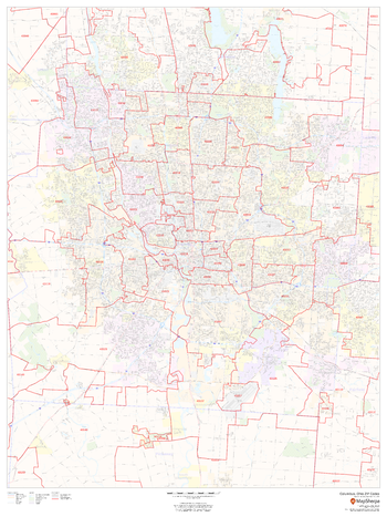
Columbus, Ohio ZIP Codes
MapSherpa
This map of Columbus shows ZIP code areas overlaid on a road map. Ideal for planning of deliveries, home services, sales territories, real estate and much more. Base map features include all roads with major roads and highways labelled; neighborhood names; railways; and high level land use such as parks and recreation areas, industrial areas and hospital campuses.
Page Size: 36 x 48 in (914 x 1219 mm)
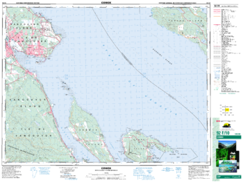
Comox - 92 F/10 - British Columbia
Natural Resources Canada
Canadian topographic map of Comox, British Columbia. NTS sheet 092F10 Edition 5.
Page Size: 34.5 x 26 in (873 x 659 mm)
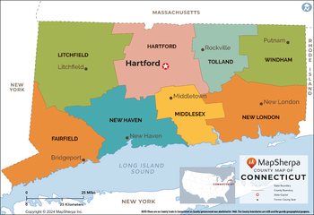
Connecticut Counties Map - Extra Large
MapSherpa
This map has been created exclusively for MapSherpa, and designed for reference or business use. Clear and clean colors & fonts matched with cartographic research makes this map of the 8 Connecticut counties easily readable and useful.
Page Size: 60 x 41.25 in (1524 x 1047 mm)
No search results