


MapSherpa Catalog
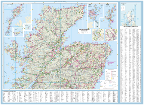
Collins Touring Map of Scotland - North
Collins
With clear mapping and a high level of detail, explore Scotland easily with maps from Collins. An ideal guide for tourists and residents alike, this map extends from Northern England in the south to Orkney and the Shetland Islands in the north, identifying more than 1000 tourist attractions, places to stay, cafes, and restaurants. It also includes detailed town centre maps of Edinburgh, Glasgow, Aberdeen, Dundee, Inverness, and Perth. An essential map for any visitors to Scotland.
Page Size: 49.75 x 36.25 in (1260 x 915 mm)
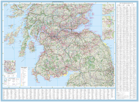
Collins Touring Map of Scotland - South
Collins
With clear mapping and a high level of detail, explore Scotland easily with maps from Collins. An ideal guide for tourists and residents alike, this map extends from Northern England in the south to Orkney and the Shetland Islands in the north, identifying more than 1000 tourist attractions, places to stay, cafes, and restaurants. It also includes detailed town centre maps of Edinburgh, Glasgow, Aberdeen, Dundee, Inverness, and Perth. An essential map for any visitors to Scotland.
Page Size: 49.75 x 36.25 in (1260 x 915 mm)
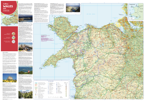
Collins Wales Map - North
Collins
With clear mapping and a high level of detail, explore North Wales easily with maps from Collins. An ideal guide for tourists and locals alike, this map identifies local attractions, places to stay, cafes, and restaurants. An essential companion or souvenir for anyone visiting Cymru.
Page Size: 32 x 22.25 in (810 x 560 mm)
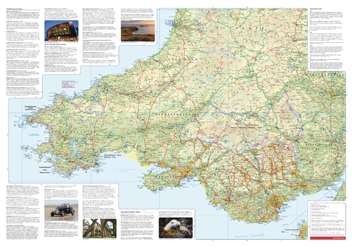
Collins Wales Map - South
Collins
With clear mapping and a high level of detail, explore South Wales easily with maps from Collins. An ideal guide for tourists and locals alike, this map identifies local attractions, places to stay, cafes, and restaurants. An essential companion or souvenir for anyone visiting Cymru.
Page Size: 32 x 22.25 in (810 x 560 mm)
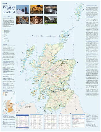
Collins Whisky Map of Scotland
Collins
Discover where Scotland’s national drink is produced. All of Scotland’s operational whisky distilleries and whisky-related places of interest, located on one map. Also includes an easy-to-use index listing visitor facilities, contact details and websites.
The map includes:
- Over 100 distilleries and whisky-related places of interest
- Insert map of malt whisky areas
- A photographic guide to how whisky is made
- Selection of labels of blended Scotch whisky brands
- Did you know? section with interesting facts
- World maps of main export markets
- Index lists visitor facilities, telephone numbers and websites
Page Size: 30.75 x 40 in (775 x 1015 mm)
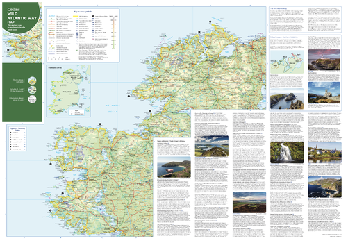
Collins Wild Atlantic Way Map - North
Collins
With clear mapping and a high level of detail, explore Ireland’s Wild Atlantic Way easily with maps from Collins. An ideal guide for tourists, locals, hikers and adventurers, this map covers the full 2500 km route (over 1500 miles), identifying tourist attractions, filming locations, places to stay, cafes, and restaurants. An essential companion or souvenir for anyone travelling along the Wild Atlantic Way.
Page Size: 32 x 22.25 in (810 x 560 mm)
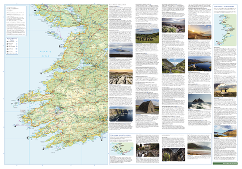
Collins Wild Atlantic Way Map - South
Collins
With clear mapping and a high level of detail, explore Ireland’s Wild Atlantic Way easily with maps from Collins. An ideal guide for tourists, locals, hikers and adventurers, this map covers the full 2500 km route (over 1500 miles), identifying tourist attractions, filming locations, places to stay, cafes, and restaurants. An essential companion or souvenir for anyone travelling along the Wild Atlantic Way.
Page Size: 32 x 22.25 in (810 x 560 mm)
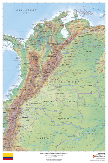
Colombia
MapSherpa
This beautiful map shows physical and political features for Colombia and surrounding areas. Relief shading and the use of different colours by height above sea level are both informative and attractive.
Page Size: 24 x 36 in (610 x 914 mm)
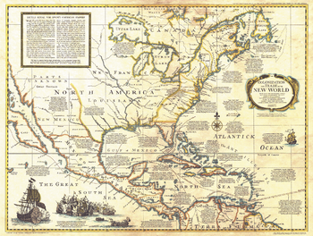
Colonization and Trade in New World - Published 1977
National Geographic
The "Colonization and Trade in the New World" historical map provides information on exploration, trade, and colonization in the New World combined with an antique-style cartography. Printed in December 1977, this map and its companion poster, "History Salvaged from the Sea" make up the two-piece set that accompanied the articles "Reach for the New World" and "Who Discovered America? A New Look at an Old Question."
Page Size: 30 x 22.75 in (761 x 573 mm)
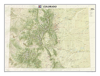
Colorado
National Geographic
The Colorado State Wall Map, part of our growing series of State Wall Maps depicts Colorado's diverse terrain and vegetation. Contains hundreds of place names and precise locations of cities, major roadways and railways, airports, federal and state parks and protected areas, mountain ranges and prominent peaks, military installations, major lakes, rivers and reservoirs, and other geographic features.
Page Size: 40.25 x 30 in (1018 x 758 mm)

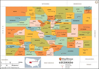
Colorado Counties Map - Extra Large
MapSherpa
This map has been created exclusively for MapSherpa, and designed for reference or business use. Clear and clean colors & fonts matched with cartographic research makes this map of Colorado Counties Map easily readable and useful. The map shows the 64 counties of Colorado and their borders across the Centennial State.
Page Size: 60 x 42 in (1524 x 1063 mm)
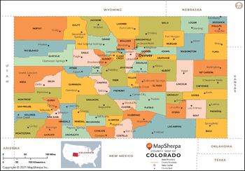
Colorado Counties Map - Large
MapSherpa
This map has been created exclusively for MapSherpa, and designed for reference or business use. Clear and clean colors & fonts matched with cartographic research makes this map of Colorado Counties Map easily readable and useful. The map shows the 64 counties of Colorado and their borders across the Centennial State.
Page Size: 48 x 33.5 in (1219 x 850 mm)
Colorado Counties Map - Standard
MapSherpa
This map has been created exclusively for MapSherpa, and designed for reference or business use. Clear and clean colors & fonts matched with cartographic research makes this map of Colorado Counties Map easily readable and useful. The map shows the 64 counties of Colorado and their borders across the Centennial State.
Page Size: 36 x 25.25 in (914 x 638 mm)
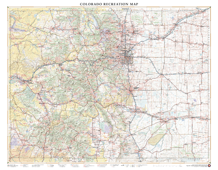
Colorado Recreation Wall Map – 26 inch
Benchmark Maps
With its capital city Denver one mile above sea level (1,609 m), fifteen separate mountain ranges, and more than fifty peaks that reach above 14,000 ft (4,267 m), Colorado attracts travelers from around the world seeking their own “Rocky Mountain High” experience. This wall map illustrates The Centennial State’s vast network of highways and byways, and the diverse public lands that make the Colorado Rockies accessible to all.
Page Size: 33.5 x 26 in (849 x 660 mm)
Colorado Springs, Colorado Inner Metro - Landscape
MapSherpa
This landscape-oriented map of central Colorado Springs, Colorado shows detailed street level information including extensive street labeling. Ideal for planning of deliveries, home services, sales territories, real estate and much more. Base map features include all roads with major roads and highways labelled; neighborhood names; railways; high level land use such as parks and recreation areas, industrial areas and hospital campuses; and a variety of points of interest including schools, libraries, stadiums, museums, border crossings and more.
Page Size: 48 x 36 in (1219 x 914 mm)
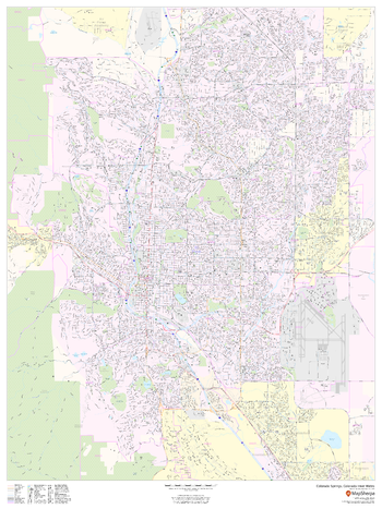
Colorado Springs, Colorado Inner Metro - Portrait
MapSherpa
This portrait-oriented map of central Colorado Springs, Colorado shows detailed street level information including extensive street labeling. Ideal for planning of deliveries, home services, sales territories, real estate and much more. Base map features include all roads with major roads and highways labelled; neighborhood names; railways; high level land use such as parks and recreation areas, industrial areas and hospital campuses; and a variety of points of interest including schools, libraries, stadiums, museums, border crossings and more.
Page Size: 36 x 48 in (914 x 1219 mm)
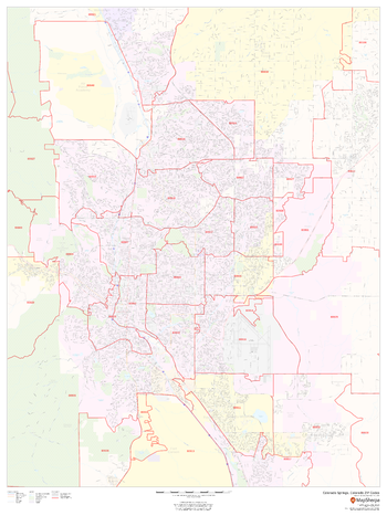
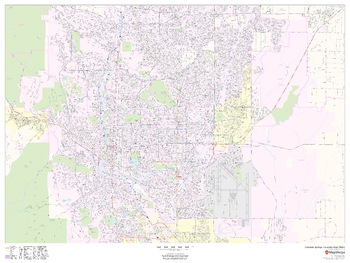
Colorado Springs, Colorado ZIP Codes
MapSherpa
This map of Colorado Springs, Colorado shows ZIP code areas overlaid on a road map. Ideal for planning of deliveries, home services, sales territories, real estate and much more. Base map features include all roads with major roads and highways labelled; neighborhood names; railways; and high level land use such as parks and recreation areas, industrial areas and hospital campuses.
Page Size: 36 x 48 in (914 x 1219 mm)
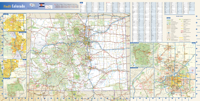
Colorado State Wall Map
Globe Turner
This colorful, easy-to-read state map of Colorado identifies all major thoroughfares, secondary roads, freeway interchanges, rest areas, distance markers, landmarks, recreational areas, and more. Shaded relief on the state map provides a three-dimensional sense of Colorado’s topography. Detailed city inset maps of Colorado Springs, Denver, For Collins, and Pueblo are based on the latest street information from our cartographic experts. The map also includes up-to-date insets of downtown Denver, Mesa Verde National Park and Rocky Mountain National Park. County and city indices make it simple to locate even the smallest town. City type sizes reflect the 2020 U.S. Census.
Page Size: 31.25 x 15.75 in (794 x 400 mm)
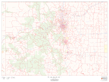
Colorado ZIP Code Map
MapSherpa
This map of Colorado shows ZIP codes overlaid on a road map. Base map features include municipality and county boundaries, major road network features, and state and national parks and conservation areas.
Page Size: 48 x 36 in (1219 x 914 mm)
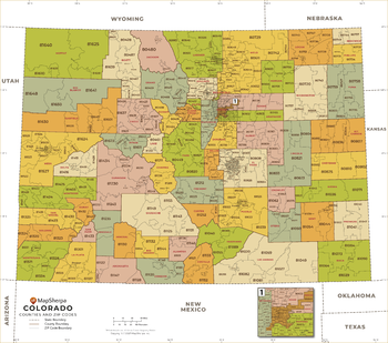
Colorado ZIP Code Map with Counties - Extra Large
MapSherpa
This map has been created exclusively for MapSherpa, and designed for business or reference use. Clear and clean colors & fonts matched with cartographic research makes this Colorado Zip Code Map with Counties easily readable and useful. The map shows the 64 counties of Colorado and the borders of the over 500 zip codes across the Centennial State.
Page Size: 60 x 53.25 in (1524 x 1347 mm)
No search results