


MapSherpa Catalog
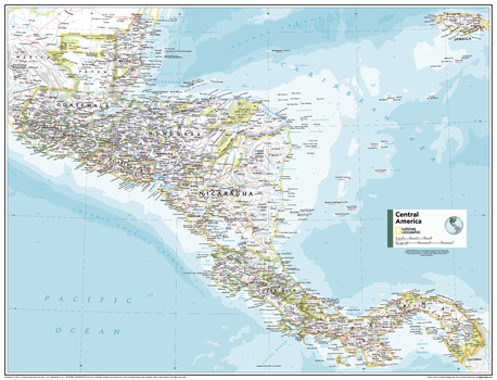
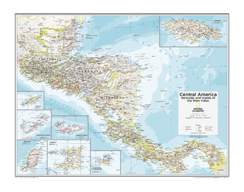
Central America - Atlas of the World, 11th Edition
National Geographic
This Central America map of physical and political features can fit in any space. Showcasing the region in stunning detail with state-of-the-art cartographic techniques delivering accuracy and exceptional quality, the innovative and engaging design makes the content easily accessible and user-friendly.
Ideal for classrooms with an emphasis on teaching geography or environmental themes. The inclusion of physical features gives your students a genuine feel for how our world appears.
This map uses a bright, easy to read color palette featuring blue oceans and stunning shaded relief that has been featured on National Geographic wall maps for over 75 years. It is drawn in the Albers Conic Equal-Area projection, which uses two standard parallels between which distortion is minimized, however scale and shape is not preserved.
Names of geographic features are carefully placed on the map to maintain legibility.
This map is found in National Geographic's 11th Edition World Atlas and is now available as a stand alone product.
Page Size: 31.5 x 24 in (798 x 610 mm)
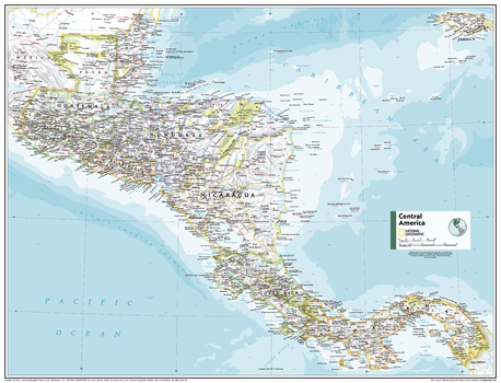
Central America - Atlas of the World, 11th Edition - Compact
National Geographic
This Central America map of physical and political features can fit in any space. Showcasing the region in stunning detail with state-of-the-art cartographic techniques delivering accuracy and exceptional quality, the innovative and engaging design makes the content easily accessible and user-friendly.
Ideal for classrooms with an emphasis on teaching geography or environmental themes. The inclusion of physical features gives your students a genuine feel for how our world appears.
This map uses a bright, easy to read color palette featuring blue oceans and stunning shaded relief that has been featured on National Geographic wall maps for over 75 years. It is drawn in the Albers Conic Equal-Area projection, which uses two standard parallels between which distortion is minimized, however scale and shape is not preserved.
Names of geographic features are carefully placed on the map to maintain legibility.
This map is found in National Geographic's 11th Edition World Atlas and is now available as a stand alone product.
Page Size: 21.5 x 16.25 in (540 x 413 mm)
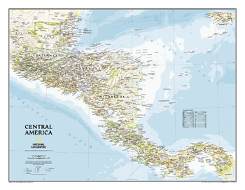
Central America Classic
National Geographic
Our most detailed wall map of Central America. Map coverage includes the countries of: Guatemala, Belize, El Salvador, Honduras, Nicaragua, Costa Rica, and Panama. Features thousands of place names, accurate boundaries, national parks, archeological sites, and major infrastructure networks such as roads, canals, ferry routes, airports, and railroads. The region's diverse terrain is detailed through accurate shaded relief, coastal bathymetry, and symbolism for water features and other land forms. Elevations, depth curves, and soundings are expressed in meters.
Page Size: 29 x 22.5 in (731 x 567 mm)
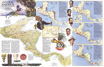
Central America Past and Present - Published 1986
National Geographic
Half of a two-map set, this map of "Central America Past and Present" accompanied the political map of Central America that appeared in the same issue. Published in April 1986, this educational map features six individual maps highlighting the history of the region and colorful illustrations of historical figures, artifacts, and wildlife.
Page Size: 31.75 x 20.5 in (801 x 517 mm)
Central America, Bermuda, and Islands of the West Indies - Atlas of the World, 10th Edition
National Geographic
Belize, Bermuda Is. (U.K.), Costa Rica, El Salvador, Grand Cayman (U.K.), Grenada, Guatemala, Honduras, Jamaica, Nicaragua, Panama, St.-Martin (Fr.), St. Maarten (Neth.),Trinidad and Tobago; Note: Bermuda Islands, a mid-Atlantic island group, is included as an inset map on this plate.
Page Size: 28 x 22 in (711 x 559 mm)
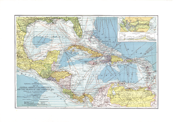
Central America, Cuba, Porto Rico, and the Islands of the Caribbean Sea - Published 1913
National Geographic
This beautiful map of Central America and the Caribbean features ocean bathymetry and colorful county borders, including overlapping colors demonstrating boundaries in dispute. Published in February 1913 one year before the completion of the Panama Canal, this work contains an abundance of unique details including principal lighthouses, U.S. Consular representatives, steamship routes, and coaling stations.
Page Size: 23.25 x 16.5 in (588 x 415 mm)
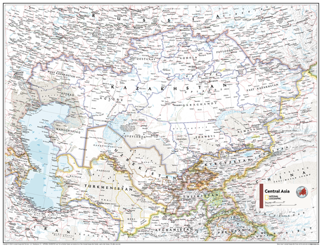
Central Asia - Atlas of the World, 10th Edition
National Geographic
Kazakhstan, Kyrgyzstan, Tajikistan, Turkmenistan, Uzbekistan
Page Size: 28 x 22 in (711 x 559 mm)
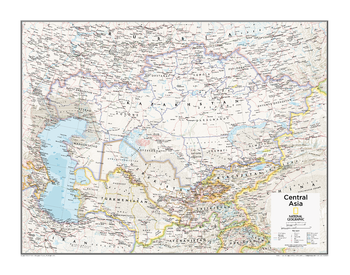
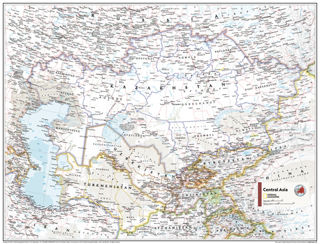
Central Asia - Atlas of the World, 11th Edition
National Geographic
This Central Asia map of physical and political features can fit in any space. Showcasing the region in stunning detail with state-of-the-art cartographic techniques delivering accuracy and exceptional quality, the innovative and engaging design makes the content easily accessible and user-friendly.
Ideal for classrooms with an emphasis on teaching geography or environmental themes. The inclusion of physical features gives your students a genuine feel for how our world appears.
This map uses a bright, easy to read color palette featuring blue oceans and stunning shaded relief that has been featured on National Geographic wall maps for over 75 years. It is drawn in the Lambert Conformal Conic projection, which seats a cone over the sphere of the Earth and projects the surface conformally onto the cone.
This map is found in National Geographic's 11th Edition World Atlas and is now available as a stand alone product.
Page Size: 31.5 x 24 in (798 x 610 mm)
Central Asia - Atlas of the World, 11th Edition - Compact
National Geographic
This Central Asia map of physical and political features can fit in any space. Showcasing the region in stunning detail with state-of-the-art cartographic techniques delivering accuracy and exceptional quality, the innovative and engaging design makes the content easily accessible and user-friendly.
Ideal for classrooms with an emphasis on teaching geography or environmental themes. The inclusion of physical features gives your students a genuine feel for how our world appears.
This map uses a bright, easy to read color palette featuring blue oceans and stunning shaded relief that has been featured on National Geographic wall maps for over 75 years. It is drawn in the Lambert Conformal Conic projection, which seats a cone over the sphere of the Earth and projects the surface conformally onto the cone.
This map is found in National Geographic's 11th Edition World Atlas and is now available as a stand alone product.
Page Size: 21.5 x 16.25 in (540 x 413 mm)
Central Canada - Atlas of the World, 10th Edition
National Geographic
null
Page Size: 28 x 22 in (711 x 559 mm)
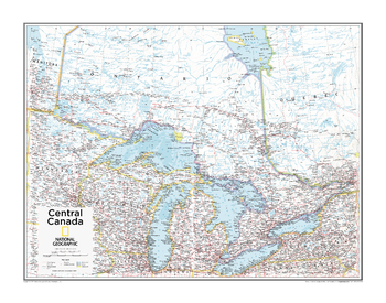
Central Canada - Atlas of the World, 11th Edition
National Geographic
This Central Canada map of physical and political features can fit in any space. Showcasing the Great Lakes region in stunning detail with state-of-the-art cartographic techniques delivering accuracy and exceptional quality, the innovative and engaging design makes the content easily accessible and user-friendly.
Ideal for classrooms with an emphasis on teaching geography or environmental themes. The inclusion of physical features gives your students a genuine feel for how our world appears.
This map uses a bright, easy to read color palette featuring blue oceans and stunning shaded relief that has been featured on National Geographic wall maps for over 75 years. It is drawn in the Albers Conic Equal-Area projection, which uses two standard parallels between which distortion is minimized.
Names of geographic features are carefully placed on the map to maintain legibility.
This map is found in National Geographic's 11th Edition World Atlas and is now available as a stand alone product.
Page Size: 31.5 x 24 in (798 x 610 mm)
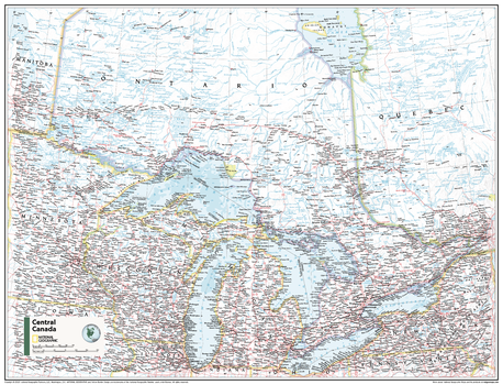
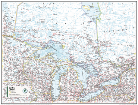
Central Canada - Atlas of the World, 11th Edition - Compact
National Geographic
This Central Canada map of physical and political features can fit in any space. Showcasing the Great Lakes region in stunning detail with state-of-the-art cartographic techniques delivering accuracy and exceptional quality, the innovative and engaging design makes the content easily accessible and user-friendly.
Ideal for classrooms with an emphasis on teaching geography or environmental themes. The inclusion of physical features gives your students a genuine feel for how our world appears.
This map uses a bright, easy to read color palette featuring blue oceans and stunning shaded relief that has been featured on National Geographic wall maps for over 75 years. It is drawn in the Albers Conic Equal-Area projection, which uses two standard parallels between which distortion is minimized.
Names of geographic features are carefully placed on the map to maintain legibility.
This map is found in National Geographic's 11th Edition World Atlas and is now available as a stand alone product.
Page Size: 21.5 x 16.25 in (540 x 413 mm)
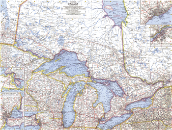
Central Canada - Published 1963
National Geographic
Discover the fascinating region of Central Canada with this compelling map. Includes inset maps of Toronto and sections of major rivers. Published in July 1963 with the article "Canada's Dynamic Heartland, Ontario." A fine companion to the maps of Eastern Canada (1967) and Western Canada (1966).
Page Size: 25 x 19 in (632 x 480 mm)
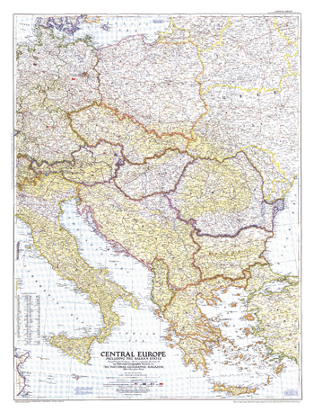
Central Europe - Published 1951
National Geographic
This map of Central Europe and the Balkan States captures Europe still in the recovery stages after World War II. Published in September 1951, it includes American, British, French, and Russian occupation zones and the newly drawn boundaries of Russia an
Page Size: 30.25 x 39.5 in (763 x 999 mm)
Central Europe - Atlas of the World, 10th Edition
National Geographic
Belarus, Czech Republic (Czechia), Kaliningrad Oblast (Russia), Lithuania, Poland, Slovakia, Ukraine
Page Size: 28 x 22 in (711 x 559 mm)
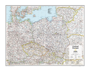
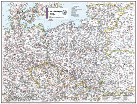
Central Europe - Atlas of the World, 11th Edition
National Geographic
This Central Europe map of physical and political features can fit in any space. Showcasing the region in stunning detail with state-of-the-art cartographic techniques delivering accuracy and exceptional quality, the innovative and engaging design makes the content easily accessible and user-friendly.
Ideal for classrooms with an emphasis on teaching geography or environmental themes. The inclusion of physical features gives your students a genuine feel for how our world appears.
This map uses a bright, easy to read color palette featuring blue oceans and stunning shaded relief that has been featured on National Geographic wall maps for over 75 years.
Names of geographic features are carefully placed on the map to maintain legibility. Lists of administrative units from multiple countries add detail to this classic map.
This map is found in National Geographic's 11th Edition World Atlas and is now available as a stand alone product.
Page Size: 31.5 x 24 in (798 x 610 mm)
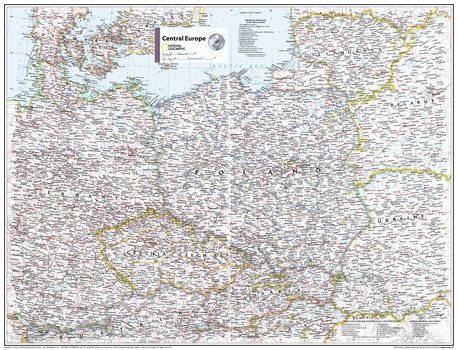
Central Europe - Atlas of the World, 11th Edition - Compact
National Geographic
This Central Europe map of physical and political features can fit in any space. Showcasing the region in stunning detail with state-of-the-art cartographic techniques delivering accuracy and exceptional quality, the innovative and engaging design makes the content easily accessible and user-friendly.
Ideal for classrooms with an emphasis on teaching geography or environmental themes. The inclusion of physical features gives your students a genuine feel for how our world appears.
This map uses a bright, easy to read color palette featuring blue oceans and stunning shaded relief that has been featured on National Geographic wall maps for over 75 years.
Names of geographic features are carefully placed on the map to maintain legibility. Lists of administrative units from multiple countries add detail to this classic map.
This map is found in National Geographic's 11th Edition World Atlas and is now available as a stand alone product.
Page Size: 21.5 x 16.25 in (540 x 413 mm)
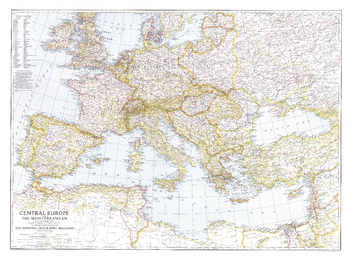
Central Europe and the Mediterranean - Published 1939
National Geographic
This map of Central Europe and the Mediterranean shows international boundaries as of September 1, 1939, before Germany invaded Poland. Published in October 1939, this map appeared with the article "War Clouds Over Danzig and Poland's Port." A unique historical map for collectors.
Page Size: 37.25 x 27.5 in (944 x 697 mm)
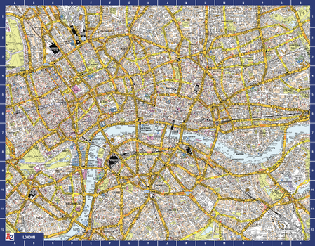
Central London A-Z Street Map
A-Z Maps
Navigate your way around central London with this detailed, easy-to-use, and up-to-date A-Z Map. A full-colour, single sided, street map. Extending to Islington to the north, Mile End to the east, Kennington to the south, and Mayfair to the west. This iconic highly detailed A-Z map is a trusted means of finding your way around the capital city.
Page Size: 28.5 x 22.25 in (718 x 560 mm)
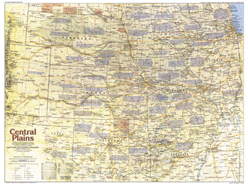
Central Plains Map Side 1 - Published 1985
National Geographic
Explore the history of America's Heartland - the Central Plains region of the United States. This map contains a wealth of historical notes as well as historical trails, national parks, ghost towns, battlefields, and more. Published in September 1985 as part of the "Making of America" series.
Page Size: 27.25 x 20.5 in (687 x 515 mm)
No search results