


MapSherpa Catalog
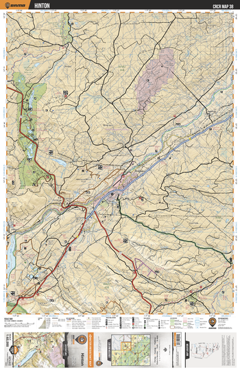
CRCR38 Hinton - Canadian Rockies Topo
Backroad Mapbooks
This recreation topographic map for Hinton highlights all the roads, fishing lakes & streams, front and backcountry campsites, paddling routes for canoeing and kayaking, wildlife viewing areas, multi-use trails for hiking, backcountry skiing, snowshoeing, mountain biking, horseback riding & more. Covering 1,950 km2 (753 mi2), this map measures 38 x 51 km (24 x 32 mi), providing you with more topographic and recreational detail for the Whiteswan Lake area than any other map on the market. Special features include private land and countless roads, trails and recreational Points of Interest. Included on this map are Hinton, Wildhay River, Athabasca River, Peppers Lake, William A Switzer Provincial Park, Brule Lake, Gregg River, McLeod River and more!
Page Size: 24 x 37 in (610 x 940 mm)
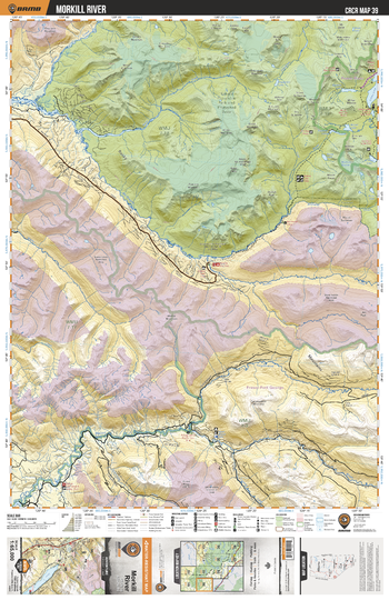
CRCR39 Morkill River - Canadian Rockies Topo
Backroad Mapbooks
This recreation topographic map for Morkill River highlights all the roads, fishing lakes & streams, front and backcountry campsites, paddling routes for canoeing and kayaking, wildlife viewing areas, multi-use trails for hiking, backcountry skiing, snowshoeing, mountain biking, horseback riding & more. Covering 1,950 km2 (753 mi2), this map measures 38 x 51 km (24 x 32 mi), providing you with more topographic and recreational detail for the Whiteswan Lake area than any other map on the market. Special features include private land and countless roads, trails and recreational Points of Interest. Included on this map are Morkill River, McGregor River, Kakwa Provincial Park and Protected Area, Forgetmenot Creek, Bastille Creek, Buchanan Creek and more!
Page Size: 24 x 37 in (610 x 940 mm)
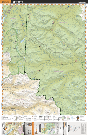
CRCR40 Sheep Creek - Canadian Rockies Topo
Backroad Mapbooks
This recreation topographic map for Sheep Creek highlights all the roads, fishing lakes & streams, front and backcountry campsites, paddling routes for canoeing and kayaking, wildlife viewing areas, multi-use trails for hiking, backcountry skiing, snowshoeing, mountain biking, horseback riding & more. Covering 1,950 km2 (753 mi2), this map measures 38 x 51 km (24 x 32 mi), providing you with more topographic and recreational detail for the Whiteswan Lake area than any other map on the market. Special features include private land and countless roads, trails and recreational Points of Interest. Included on this map are Sheep Creek, Kawka Wildland Provincial Park, Kawka Provincial Park, Willmore Wilderness Provincial Park, Muddywater River and more!
Page Size: 24 x 37 in (610 x 940 mm)
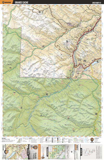
CRCR41 Grande Cache - Canadian Rockies Topo
Backroad Mapbooks
This recreation topographic map for Grande Cache highlights all the roads, fishing lakes & streams, front and backcountry campsites, paddling routes for canoeing and kayaking, wildlife viewing areas, multi-use trails for hiking, backcountry skiing, snowshoeing, mountain biking, horseback riding & more. Covering 1,950 km2 (753 mi2), this map measures 38 x 51 km (24 x 32 mi), providing you with more topographic and recreational detail for the Whiteswan Lake area than any other map on the market. Special features include private land and countless roads, trails and recreational Points of Interest. Included on this map are Grand Cache, Smoky River, Sulphur River, Muddywater River, Sheep Creek, Willmore Wilderness Provincial Park, Muskeg River and more!
Page Size: 24 x 37 in (610 x 940 mm)
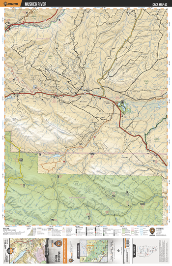
CRCR42 Muskeg River - Canadian Rockies Topo
Backroad Mapbooks
This recreation topographic map for Muskeg River highlights all the roads, fishing lakes & streams, front and backcountry campsites, paddling routes for canoeing and kayaking, wildlife viewing areas, multi-use trails for hiking, backcountry skiing, snowshoeing, mountain biking, horseback riding & more. Covering 1,950 km2 (753 mi2), this map measures 38 x 51 km (24 x 32 mi), providing you with more topographic and recreational detail for the Whiteswan Lake area than any other map on the market. Special features include private land and countless roads, trails and recreational Points of Interest. Included on this map are Muskeg River, Willmore Wilderness Provincial Park, Smoky River, A la Peche Lake, Berland River, Cowlick Creek, Peavine Lake and more!
Page Size: 24 x 37 in (610 x 940 mm)
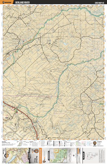
CRCR43 Berland river - Canadian Rockies Topo
Backroad Mapbooks
This recreation topographic map for Berland river highlights all the roads, fishing lakes & streams, front and backcountry campsites, paddling routes for canoeing and kayaking, wildlife viewing areas, multi-use trails for hiking, backcountry skiing, snowshoeing, mountain biking, horseback riding & more. Covering 1,950 km2 (753 mi2), this map measures 38 x 51 km (24 x 32 mi), providing you with more topographic and recreational detail for the Whiteswan Lake area than any other map on the market. Special features include private land and countless roads, trails and recreational Points of Interest. Included on this map are Berland River, Little Smoky River, Little Berland River, Donald Lake, Pinto Creek Canyon Natural Area, Joachim Lakes and more!
Page Size: 24 x 37 in (610 x 940 mm)
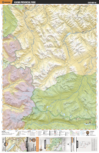
CRCR44 Kawka Provincial Park - Canadian Rockies Topo
Backroad Mapbooks
This recreation topographic map for Kawka Provincial Park highlights all the roads, fishing lakes & streams, front and backcountry campsites, paddling routes for canoeing and kayaking, wildlife viewing areas, multi-use trails for hiking, backcountry skiing, snowshoeing, mountain biking, horseback riding & more. Covering 1,950 km2 (753 mi2), this map measures 38 x 51 km (24 x 32 mi), providing you with more topographic and recreational detail for the Whiteswan Lake area than any other map on the market. Special features include private land and countless roads, trails and recreational Points of Interest. Included on this map are Wapiti Lake Provincial Park, Kawka Provincial Park, Wapiti Lake Provincial Park, Belcourt Lake, Knudsen Lake Rec Reserve, Jarvis Lakes and more!
Page Size: 24 x 37 in (610 x 940 mm)
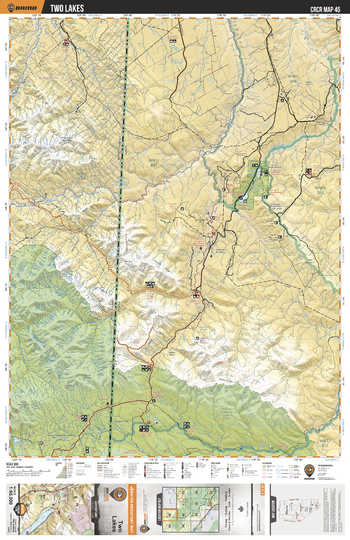
CRCR45 Two Lakes - Canadian Rockies Topo
Backroad Mapbooks
This recreation topographic map for Two Lakes highlights all the roads, fishing lakes & streams, front and backcountry campsites, paddling routes for canoeing and kayaking, wildlife viewing areas, multi-use trails for hiking, backcountry skiing, snowshoeing, mountain biking, horseback riding & more. Covering 1,950 km2 (753 mi2), this map measures 38 x 51 km (24 x 32 mi), providing you with more topographic and recreational detail for the Whiteswan Lake area than any other map on the market. Special features include private land and countless roads, trails and recreational Points of Interest. Included on this map are Two Lakes, Two Lakes Provincial park, Kawka Provincial Park, Kawka Wildland Provincial Park, Kawka River, Torrens River, Narraway River and more!
Page Size: 24 x 37 in (610 x 940 mm)
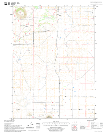
Cabin Lake Quadrangle, Oregon
United States Department of Agriculture Forest Service
United States Department of Agriculture Forestry Service topographical map of Cabin Lake, Deschutes National Forest, Oregon.
Page Size: 21.75 x 27 in (552 x 686 mm)
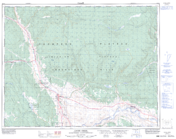
Cache Creek - 92 I/14 - British Columbia
Natural Resources Canada
Canadian topographic map of Cache Creek, British Columbia. NTS sheet 092I14 Edition 3.
Page Size: 32.25 x 25.5 in (814 x 647 mm)
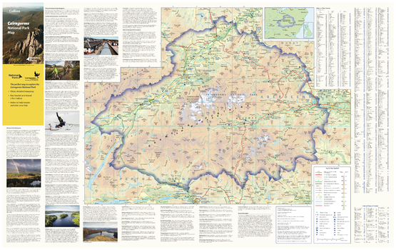
Cairngorms National Park Map
Collins
With clear mapping and a high level of detail, explore Cairngorms National Park easily with maps from Collins. This map identifies key park, tourist, and travel information, presented alongside a selection of photographs, making it an ideal companion for those exploring this beautiful area of the Scottish Highlands.
Page Size: 35.5 x 22.25 in (900 x 560 mm)
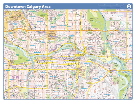
Calgary Downtown
Lucidmap
Map of downtown Calgary showing all roads, road names, political boundaries, transit, points of interest, parks, schools, churches, public buildings and landmarks.
Page Size: 28 x 40 in (711 x 1016 mm)
Calgary Downtown - Compact
Lucidmap
Map of downtown Calgary showing all roads, road names, political boundaries, transit, points of interest, parks, schools, churches, public buildings and landmarks.
Page Size: 21.5 x 16.25 in (546 x 413 mm)
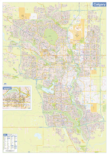
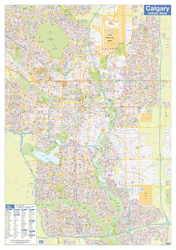
Calgary Wall Map - Street Detail - Large
Lucidmap
This large wall map shows highly detailed local information for the city of Calgary. Full street labeling along with transit information, parks, schools, churches and landmarks throughout the city are displayed.
The map has been designed in a very clear and legible manner with a traditional Canadian street map style embraced by map buyers over many years.
Page Size: 37.25 x 53.5 in (942 x 1357 mm)
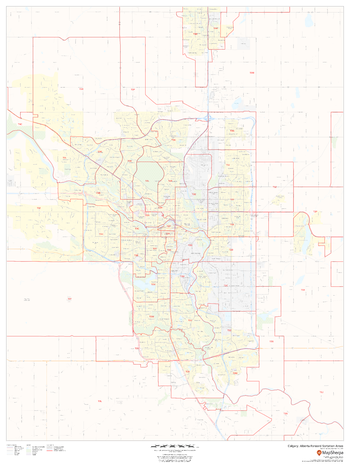
Calgary, Alberta Postal Code Forward Sortation Areas
MapSherpa
This map of Calgary shows postal code forward sortation areas overlaid on a road map. Ideal for planning of deliveries, home services, sales territories, real estate and much more. Base map features include all roads with major roads and highways labelled; neighbourhood names; railways; and high level land use such as parks and recreation areas, industrial areas and hospital campuses.
Page Size: 36 x 48 in (914 x 1219 mm)
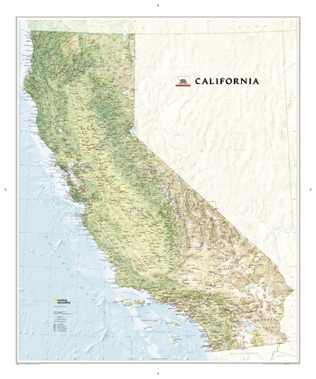
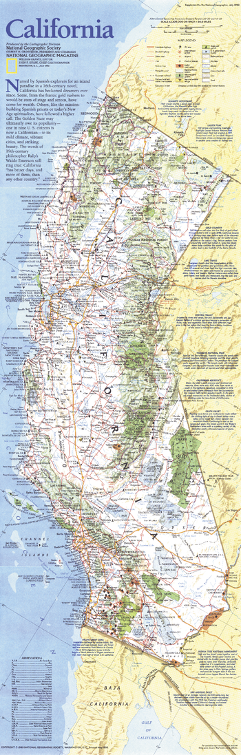
California
National Geographic
This map offers a dramatic visualization of California's physical geography. Land cover colorization distinguishes forests and deserts. Stunning shaded relief depicts mountains and ocean depths. The map locates and names cities, towns, islands airports, national and state parks, military bases, mountains (with peak elevations), lakes, rivers, and other natural features.
Page Size: 35.25 x 42.25 in (894 x 1071 mm)
California - Published 1993
National Geographic
This map of California highlights an abundance of parks, forests, beaches, wildlife refuges, ski areas, and more. Notes on such areas as Lake Tahoe, Yosemite, the Gold Country, and Death Valley provide additional information about the spectacular sites to be found in this diverse and exciting state. Published in July 1993.
Page Size: 10 x 31.25 in (253 x 792 mm)
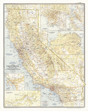
California - Published 1954
National Geographic
This attractive map of California was the first map National Geographic published of "The Golden State". California is the third largest state by land area and the most populous state in the United States. Its diverse places of interest are highlighted with descriptive notes. Insets reveal detail of the largest cities -- Los Angeles, San Francisco, and San Diego -- in addition to the San Francisco Bay Region and the Yosemite Valley. Published in June 1954.
Page Size: 30 x 38 in (761 x 962 mm)
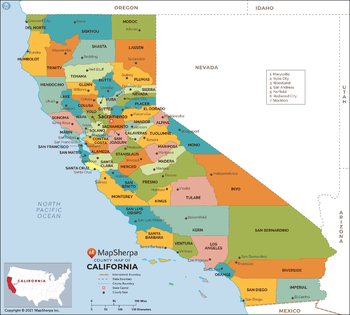
California Counties Map - Extra Large
MapSherpa
This map has been created exclusively for MapSherpa, and designed for reference or business use. Clear and clean colors & fonts matched with cartographic research makes this map of California Counties Map easily readable and useful. The map shows the 58 counties of California and their borders across the Golden State.
Page Size: 60 x 54 in (1524 x 1372 mm)

California Counties Map - Large
MapSherpa
This map has been created exclusively for MapSherpa, and designed for reference or business use. Clear and clean colors & fonts matched with cartographic research makes this map of California Counties Map easily readable and useful. The map shows the 58 counties of California and their borders across the Golden State.
Page Size: 48 x 43.25 in (1219 x 1097 mm)
No search results