


MapSherpa Catalog
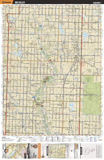
CEAB07 Big Valley - Central Alberta Topo
Backroad Mapbooks
This recreation topographic map for Big Valley highlights all the logging and resource roads, multi-use trails for hikers, mountain bikers, horseback riders, cross-country skiers and snowshoers, motorized trails for ATVers and snowmobiles, fishing lakes and rivers, recreation areas, campgrounds, day-use areas, viewpoints, backcountry campsites, work camps, oil & gas sites, backcountry huts and cabins and more. No other map for the area provides you with this level of recreational or topographic detail. Covering 3,040 km2 (1,175 mi2) in total, this 1:85,000 scale map measures 48 x 63.5 km (30 x 39.5 mi). Special features include enhanced oil & gas data plus countless roads, trails and recreational Points of Interest. This map includes Rumsey Natural Area, Dry Island Buffalo Jump Prov Park, Red Deer River, Lowden Lake, Big Valley, Mudspring Lake, Trochu, Delburne, Ewing Lake, Warden and more!
Page Size: 24 x 37 in (610 x 940 mm)
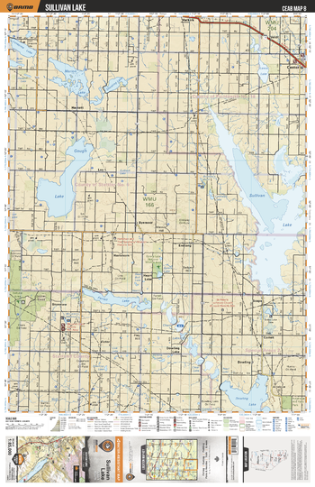
CEAB08 Sullivan Lake - Central Alberta Topo
Backroad Mapbooks
This recreation topographic map for Sullivan Lake highlights all the logging and resource roads, multi-use trails for hikers, mountain bikers, horseback riders, cross-country skiers and snowshoers, motorized trails for ATVers and snowmobiles, fishing lakes and rivers, recreation areas, campgrounds, day-use areas, viewpoints, backcountry campsites, work camps, oil & gas sites, backcountry huts and cabins and more. No other map for the area provides you with this level of recreational or topographic detail. Covering 3,040 km2 (1,175 mi2) in total, this 1:85,000 scale map measures 48 x 63.5 km (30 x 39.5 mi). Special features include enhanced oil & gas data plus countless roads, trails and recreational Points of Interest. This map includes Sullivan Lake, Gough Lake, Dowling Lake, Farrell Lake, Marion Lake, Castor, Heart Lake, Lonepine Lake, Halkirk, Battle River and more!
Page Size: 24 x 37 in (610 x 940 mm)
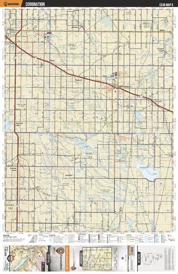
CEAB09 Coronation - Central Alberta Topo
Backroad Mapbooks
This recreation topographic map for Coronation highlights all the logging and resource roads, multi-use trails for hikers, mountain bikers, horseback riders, cross-country skiers and snowshoers, motorized trails for ATVers and snowmobiles, fishing lakes and rivers, recreation areas, campgrounds, day-use areas, viewpoints, backcountry campsites, work camps, oil & gas sites, backcountry huts and cabins and more. No other map for the area provides you with this level of recreational or topographic detail. Covering 3,040 km2 (1,175 mi2) in total, this 1:85,000 scale map measures 48 x 63.5 km (30 x 39.5 mi). Special features include enhanced oil & gas data plus countless roads, trails and recreational Points of Interest. This map includes Kirkpatrick Lake, Craig Lake, Sullivan Lake, Coronation, Throne, Fleet, Castor, Spondin, Copper Creek, Talbot and more!
Page Size: 24 x 37 in (610 x 940 mm)
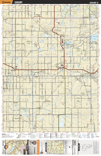
CEAB10 Consort - Central Alberta Topo
Backroad Mapbooks
This recreation topographic map for Consort highlights all the logging and resource roads, multi-use trails for hikers, mountain bikers, horseback riders, cross-country skiers and snowshoers, motorized trails for ATVers and snowmobiles, fishing lakes and rivers, recreation areas, campgrounds, day-use areas, viewpoints, backcountry campsites, work camps, oil & gas sites, backcountry huts and cabins and more. No other map for the area provides you with this level of recreational or topographic detail. Covering 3,040 km2 (1,175 mi2) in total, this 1:85,000 scale map measures 48 x 63.5 km (30 x 39.5 mi). Special features include enhanced oil & gas data plus countless roads, trails and recreational Points of Interest. This map includes Consort, Gooseberry Lake, Sounding Lake, Veteran, Neutral Valley, Lloyd Hills, Cousins, Loyalist, Monitor, Wiste and more!
Page Size: 24 x 37 in (610 x 940 mm)
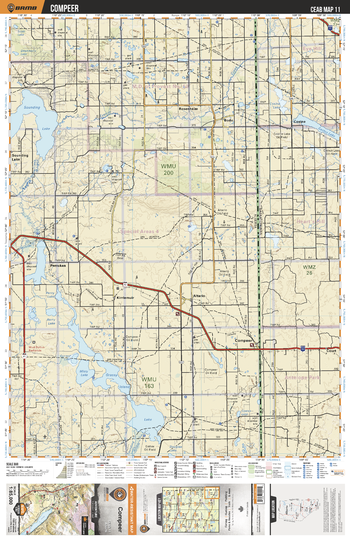
CEAB11 Compeer - Central Alberta Topo
Backroad Mapbooks
This recreation topographic map for Compeer highlights all the logging and resource roads, multi-use trails for hikers, mountain bikers, horseback riders, cross-country skiers and snowshoers, motorized trails for ATVers and snowmobiles, fishing lakes and rivers, recreation areas, campgrounds, day-use areas, viewpoints, backcountry campsites, work camps, oil & gas sites, backcountry huts and cabins and more. No other map for the area provides you with this level of recreational or topographic detail. Covering 3,040 km2 (1,175 mi2) in total, this 1:85,000 scale map measures 48 x 63.5 km (30 x 39.5 mi). Special features include enhanced oil & gas data plus countless roads, trails and recreational Points of Interest. This map includes Grassy Island Lake, Misty Lake, Pemukan, Kirriemuir, Altario, Compeer, Court, Cosine, Bodo, Sounding Lake and more!
Page Size: 24 x 37 in (610 x 940 mm)
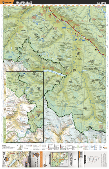
CEAB12 Athabasca Pass - Central Alberta Topo
Backroad Mapbooks
This recreation topographic map for Athabasca Pass highlights all the logging and resource roads, multi-use trails for hikers, mountain bikers, horseback riders, cross-country skiers and snowshoers, motorized trails for ATVers and snowmobiles, fishing lakes and rivers, recreation areas, campgrounds, day-use areas, viewpoints, backcountry campsites, work camps, oil & gas sites, backcountry huts and cabins and more. No other map for the area provides you with this level of recreational or topographic detail. Covering 3,040 km2 (1,175 mi2) in total, this 1:85,000 scale map measures 48 x 63.5 km (30 x 39.5 mi). Special features include enhanced oil & gas data plus countless roads, trails and recreational Points of Interest. This map includes Maligne Lake, Fortress Lake, Athabasca River, Jasper National Park, Whirlpool River, Maligne River, Hamber Provincial Park and more!
Page Size: 24 x 37 in (610 x 940 mm)
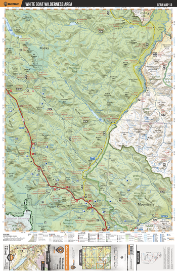
CEAB13 White Goat Wilderness Area - Central Alberta Topo
Backroad Mapbooks
This recreation topographic map for White Goat Wilderness Area highlights all the logging and resource roads, multi-use trails for hikers, mountain bikers, horseback riders, cross-country skiers and snowshoers, motorized trails for ATVers and snowmobiles, fishing lakes and rivers, recreation areas, campgrounds, day-use areas, viewpoints, backcountry campsites, work camps, oil & gas sites, backcountry huts and cabins and more. No other map for the area provides you with this level of recreational or topographic detail. Covering 3,040 km2 (1,175 mi2) in total, this 1:85,000 scale map measures 48 x 63.5 km (30 x 39.5 mi). Special features include enhanced oil & gas data plus countless roads, trails and recreational Points of Interest. This map includes White Goat Wilderness Area, Jasper National Park, Brazeau Lake, Banff National Park, Southesk River and more!
Page Size: 24 x 37 in (610 x 940 mm)
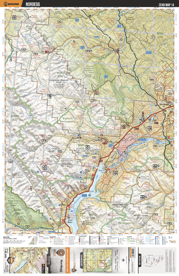
CEAB14 Nordegg - Central Alberta Topo
Backroad Mapbooks
This recreation topographic map for Nordegg highlights all the logging and resource roads, multi-use trails for hikers, mountain bikers, horseback riders, cross-country skiers and snowshoers, motorized trails for ATVers and snowmobiles, fishing lakes and rivers, recreation areas, campgrounds, day-use areas, viewpoints, backcountry campsites, work camps, oil & gas sites, backcountry huts and cabins and more. No other map for the area provides you with this level of recreational or topographic detail. Covering 3,040 km2 (1,175 mi2) in total, this 1:85,000 scale map measures 48 x 63.5 km (30 x 39.5 mi). Special features include enhanced oil & gas data plus countless roads, trails and recreational Points of Interest. This map includes Abraham Lake, Nordegg, North Saskatchewan River, Cline River, Bighorn Wildland Area, Bighorn River, Blackstone River, Whitegoat Lakes, Wapiabi Provincial Recreation Area, North Ram River and more!
Page Size: 24 x 37 in (610 x 940 mm)
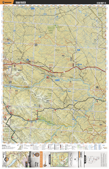
CEAB15 Ram River - Central Alberta Topo
Backroad Mapbooks
This recreation topographic map for Ram River highlights all the logging and resource roads, multi-use trails for hikers, mountain bikers, horseback riders, cross-country skiers and snowshoers, motorized trails for ATVers and snowmobiles, fishing lakes and rivers, recreation areas, campgrounds, day-use areas, viewpoints, backcountry campsites, work camps, oil & gas sites, backcountry huts and cabins and more. No other map for the area provides you with this level of recreational or topographic detail. Covering 3,040 km2 (1,175 mi2) in total, this 1:85,000 scale map measures 48 x 63.5 km (30 x 39.5 mi). Special features include enhanced oil & gas data plus countless roads, trails and recreational Points of Interest. This map includes North Saskatchewan River, Nordegg, McGregor Lake, North Ram River, Jock Lake, Baptiste River, Jackfish Lake, Harlech, Chambers Creek, Saunders and more!
Page Size: 24 x 37 in (610 x 940 mm)
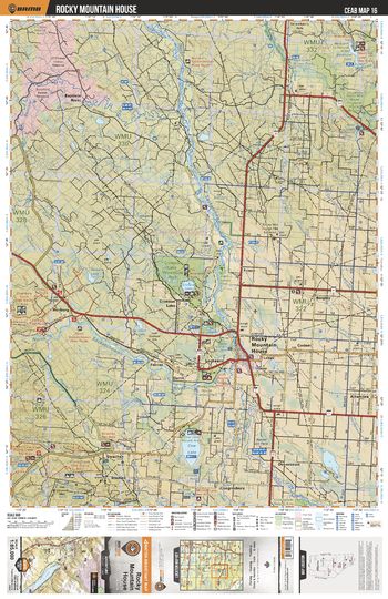
CEAB16 Rocky Mountain House - Central Alberta Topo
Backroad Mapbooks
This recreation topographic map for Rocky Mountain House highlights all the logging and resource roads, multi-use trails for hikers, mountain bikers, horseback riders, cross-country skiers and snowshoers, motorized trails for ATVers and snowmobiles, fishing lakes and rivers, recreation areas, campgrounds, day-use areas, viewpoints, backcountry campsites, work camps, oil & gas sites, backcountry huts and cabins and more. No other map for the area provides you with this level of recreational or topographic detail. Covering 3,040 km2 (1,175 mi2) in total, this 1:85,000 scale map measures 48 x 63.5 km (30 x 39.5 mi). Special features include enhanced oil & gas data plus countless roads, trails and recreational Points of Interest. This map includes Rocky Mountain House, Crimson Lake, Cow Lake, Medicine Lake, Dovercourt, Strachan, North Saskatchewan River, Ferrier, Horburg, Baptiste River and more!
Page Size: 24 x 37 in (610 x 940 mm)
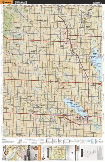
CEAB17 Sylvan Lake - Central Alberta Topo
Backroad Mapbooks
This recreation topographic map for Sylvan Lake highlights all the logging and resource roads, multi-use trails for hikers, mountain bikers, horseback riders, cross-country skiers and snowshoers, motorized trails for ATVers and snowmobiles, fishing lakes and rivers, recreation areas, campgrounds, day-use areas, viewpoints, backcountry campsites, work camps, oil & gas sites, backcountry huts and cabins and more. No other map for the area provides you with this level of recreational or topographic detail. Covering 3,040 km2 (1,175 mi2) in total, this 1:85,000 scale map measures 48 x 63.5 km (30 x 39.5 mi). Special features include enhanced oil & gas data plus countless roads, trails and recreational Points of Interest. This map includes Gull Lake, Sylvan Lake, Jarvis Bay, Parkland Beach, Bluffton, Willesden Green, Gilby, Leslieville, Stockholm, Prevo and more!
Page Size: 24 x 37 in (610 x 940 mm)
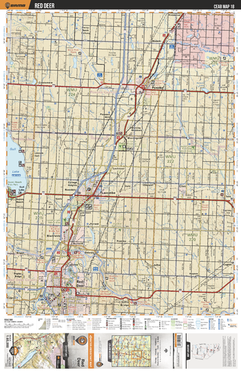
CEAB18 Red Deer - Central Alberta Topo
Backroad Mapbooks
This recreation topographic map for Red Deer highlights all the logging and resource roads, multi-use trails for hikers, mountain bikers, horseback riders, cross-country skiers and snowshoers, motorized trails for ATVers and snowmobiles, fishing lakes and rivers, recreation areas, campgrounds, day-use areas, viewpoints, backcountry campsites, work camps, oil & gas sites, backcountry huts and cabins and more. No other map for the area provides you with this level of recreational or topographic detail. Covering 3,040 km2 (1,175 mi2) in total, this 1:85,000 scale map measures 48 x 63.5 km (30 x 39.5 mi). Special features include enhanced oil & gas data plus countless roads, trails and recreational Points of Interest. This map includes Gull Lake, Red Deer, Blackfalds, Lacombe, Morningside, Ponoka, Battle River, Red Deer River, Clive, Tees and more!
Page Size: 24 x 37 in (610 x 940 mm)
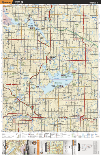
CEAB19 Stettler - Central Alberta Topo
Backroad Mapbooks
This recreation topographic map for Stettler highlights all the logging and resource roads, multi-use trails for hikers, mountain bikers, horseback riders, cross-country skiers and snowshoers, motorized trails for ATVers and snowmobiles, fishing lakes and rivers, recreation areas, campgrounds, day-use areas, viewpoints, backcountry campsites, work camps, oil & gas sites, backcountry huts and cabins and more. No other map for the area provides you with this level of recreational or topographic detail. Covering 3,040 km2 (1,175 mi2) in total, this 1:85,000 scale map measures 48 x 63.5 km (30 x 39.5 mi). Special features include enhanced oil & gas data plus countless roads, trails and recreational Points of Interest. This map includes Buffalo Lake, Red Deer Lake, Mirror, Stettler, Rochon Sands, Alix Lake, Erskine, Red Deer River, Meeting Creek, Ferintosh and more!
Page Size: 24 x 37 in (610 x 940 mm)
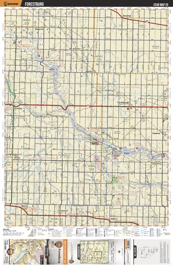
CEAB20 Forestburg - Central Alberta Topo
Backroad Mapbooks
This recreation topographic map for Forestburg highlights all the logging and resource roads, multi-use trails for hikers, mountain bikers, horseback riders, cross-country skiers and snowshoers, motorized trails for ATVers and snowmobiles, fishing lakes and rivers, recreation areas, campgrounds, day-use areas, viewpoints, backcountry campsites, work camps, oil & gas sites, backcountry huts and cabins and more. No other map for the area provides you with this level of recreational or topographic detail. Covering 3,040 km2 (1,175 mi2) in total, this 1:85,000 scale map measures 48 x 63.5 km (30 x 39.5 mi). Special features include enhanced oil & gas data plus countless roads, trails and recreational Points of Interest. This map includes Battle River, Forestburg, Big Knife Prov Park, Paintearth Badlands, Halkirk, Botha, Gadsby, Galahad, Red Willow, Rosalind and more!
Page Size: 24 x 37 in (610 x 940 mm)
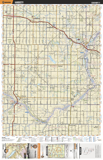
CEAB21 Hardisty - Central Alberta Topo
Backroad Mapbooks
This recreation topographic map for Hardisty highlights all the logging and resource roads, multi-use trails for hikers, mountain bikers, horseback riders, cross-country skiers and snowshoers, motorized trails for ATVers and snowmobiles, fishing lakes and rivers, recreation areas, campgrounds, day-use areas, viewpoints, backcountry campsites, work camps, oil & gas sites, backcountry huts and cabins and more. No other map for the area provides you with this level of recreational or topographic detail. Covering 3,040 km2 (1,175 mi2) in total, this 1:85,000 scale map measures 48 x 63.5 km (30 x 39.5 mi). Special features include enhanced oil & gas data plus countless roads, trails and recreational Points of Interest. This map includes Hardisty, Alliance, Sedgewick, Lougheed, Rosyth, Brownfield, Bellshill, Battle River, Fish Lake, Killam and more!
Page Size: 24 x 37 in (610 x 940 mm)
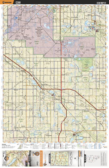
CEAB22 Czar - Central Alberta Topo
Backroad Mapbooks
This recreation topographic map for Czar highlights all the logging and resource roads, multi-use trails for hikers, mountain bikers, horseback riders, cross-country skiers and snowshoers, motorized trails for ATVers and snowmobiles, fishing lakes and rivers, recreation areas, campgrounds, day-use areas, viewpoints, backcountry campsites, work camps, oil & gas sites, backcountry huts and cabins and more. No other map for the area provides you with this level of recreational or topographic detail. Covering 3,040 km2 (1,175 mi2) in total, this 1:85,000 scale map measures 48 x 63.5 km (30 x 39.5 mi). Special features include enhanced oil & gas data plus countless roads, trails and recreational Points of Interest. This map includes Houcher Lake, Hughenden, Amisk, Czar, Buffalo View, Park Farm, Bushy Head Corner, Shorncliffe Lake, Asul, Captain Ayre Lake and more!
Page Size: 24 x 37 in (610 x 940 mm)
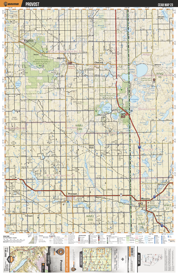
CEAB23 Provost - Central Alberta Topo
Backroad Mapbooks
This recreation topographic map for Provost highlights all the logging and resource roads, multi-use trails for hikers, mountain bikers, horseback riders, cross-country skiers and snowshoers, motorized trails for ATVers and snowmobiles, fishing lakes and rivers, recreation areas, campgrounds, day-use areas, viewpoints, backcountry campsites, work camps, oil & gas sites, backcountry huts and cabins and more. No other map for the area provides you with this level of recreational or topographic detail. Covering 3,040 km2 (1,175 mi2) in total, this 1:85,000 scale map measures 48 x 63.5 km (30 x 39.5 mi). Special features include enhanced oil & gas data plus countless roads, trails and recreational Points of Interest. This map includes Killarney Lake, Reflex Lakes, Ribstone, Provost, Macklin, Chauvin, Dunn, Edgerton, Artland, Green Glade and more!
Page Size: 24 x 37 in (610 x 940 mm)
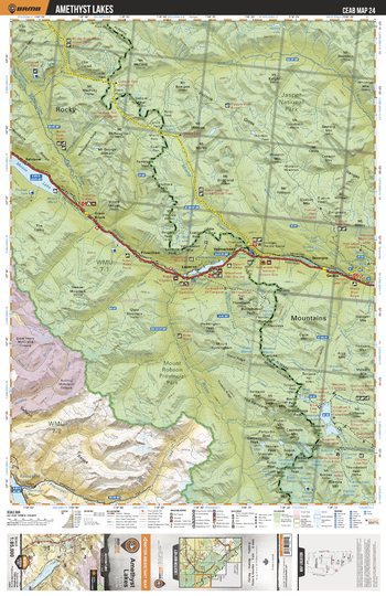
CEAB24 Amethyst Lakes - Central Alberta Topo
Backroad Mapbooks
This recreation topographic map for Amethyst Lakes highlights all the logging and resource roads, multi-use trails for hikers, mountain bikers, horseback riders, cross-country skiers and snowshoers, motorized trails for ATVers and snowmobiles, fishing lakes and rivers, recreation areas, campgrounds, day-use areas, viewpoints, backcountry campsites, work camps, oil & gas sites, backcountry huts and cabins and more. No other map for the area provides you with this level of recreational or topographic detail. Covering 3,040 km2 (1,175 mi2) in total, this 1:85,000 scale map measures 48 x 63.5 km (30 x 39.5 mi). Special features include enhanced oil & gas data plus countless roads, trails and recreational Points of Interest. This map includes Amethyst Lakes, Mount Robson Provincial Park, Jasper National Park, Moose Lake, Kinbasket Lake, Yellowhead Lake, Snaring River and more!
Page Size: 24 x 37 in (610 x 940 mm)
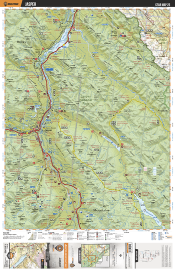
CEAB25 Jasper - Central Alberta Topo
Backroad Mapbooks
This recreation topographic map for Jasper highlights all the logging and resource roads, multi-use trails for hikers, mountain bikers, horseback riders, cross-country skiers and snowshoers, motorized trails for ATVers and snowmobiles, fishing lakes and rivers, recreation areas, campgrounds, day-use areas, viewpoints, backcountry campsites, work camps, oil & gas sites, backcountry huts and cabins and more. No other map for the area provides you with this level of recreational or topographic detail. Covering 3,040 km2 (1,175 mi2) in total, this 1:85,000 scale map measures 48 x 63.5 km (30 x 39.5 mi). Special features include enhanced oil & gas data plus countless roads, trails and recreational Points of Interest. This map includes Jasper, Jasper National Park, Whitehorse Wildland Provincial Park, Jasper Lake, Athabasca River, Rocky River, Medicine Lake and more!
Page Size: 24 x 37 in (610 x 940 mm)
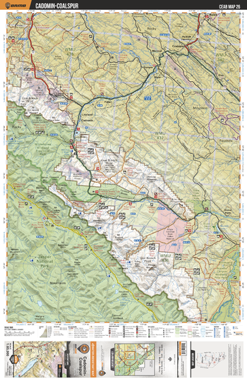
CEAB26 Cadomin-Coalspur - Central Alberta Topo
Backroad Mapbooks
This recreation topographic map for Cadomin-Coalspur highlights all the logging and resource roads, multi-use trails for hikers, mountain bikers, horseback riders, cross-country skiers and snowshoers, motorized trails for ATVers and snowmobiles, fishing lakes and rivers, recreation areas, campgrounds, day-use areas, viewpoints, backcountry campsites, work camps, oil & gas sites, backcountry huts and cabins and more. No other map for the area provides you with this level of recreational or topographic detail. Covering 3,040 km2 (1,175 mi2) in total, this 1:85,000 scale map measures 48 x 63.5 km (30 x 39.5 mi). Special features include enhanced oil & gas data plus countless roads, trails and recreational Points of Interest. This map includes Jasper National Park, Whitehorse Wildland Prov Park, McLeod River, Brazeau River, Medicine Tent River, Grave Flats, Cadomin, Coalspur, Cardinal River, Fidler and more!
Page Size: 24 x 37 in (610 x 940 mm)
No search results