


MapSherpa Catalog
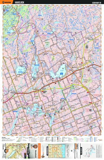
CCON26 Havelock - Cottage Country Ontario Topo
Backroad Mapbooks
This recreation topographic map for Havelock highlights all the logging/resource roads, hunting areas, fishing lakes & streams, campsites, paddling routes for canoeing and kayaking, wildlife viewing areas, multi-use trails for hiking, biking, horseback riding, cross-country skiing and snowshoeing, motorized trails for ATVing and snowmobiling & more. Covering 1,090 km2 (420 mi2), this 1:50,000 scale map measures 29 x 38 km (18 x 24 mi), providing you with more topographic and recreational detail for the Richmond Hill area than any other map on the market. New features include enhanced Crown land, countless new roads and trails and a wealth of recreational Points of Interest. Included on this map are Havelock, Marmora, Rockdale, Bonarlaw, Preneveau, Pethericks Corners, Allan Mills and more!
Page Size: 24 x 37 in (610 x 940 mm)
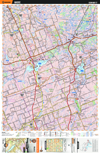
CCON27 Madoc - Cottage Country Ontario Topo
Backroad Mapbooks
This recreation topographic map for Madoc highlights all the logging/resource roads, hunting areas, fishing lakes & streams, campsites, paddling routes for canoeing and kayaking, wildlife viewing areas, multi-use trails for hiking, biking, horseback riding, cross-country skiing and snowshoeing, motorized trails for ATVing and snowmobiling & more. Covering 1,090 km2 (420 mi2), this 1:50,000 scale map measures 29 x 38 km (18 x 24 mi), providing you with more topographic and recreational detail for the Richmond Hill area than any other map on the market. New features include enhanced Crown land, countless new roads and trails and a wealth of recreational Points of Interest. Included on this map are Madoc, Tweed, Queensborough, Actinolite, Hastings, Trail, Moneymore and more!
Page Size: 24 x 37 in (610 x 940 mm)
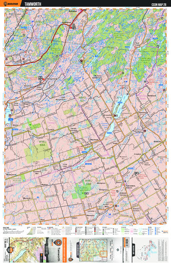
CCON28 Tamworth - Cottage Country Ontario Topo
Backroad Mapbooks
This recreation topographic map for Tamworth highlights all the logging/resource roads, hunting areas, fishing lakes & streams, campsites, paddling routes for canoeing and kayaking, wildlife viewing areas, multi-use trails for hiking, biking, horseback riding, cross-country skiing and snowshoeing, motorized trails for ATVing and snowmobiling & more. Covering 1,090 km2 (420 mi2), this 1:50,000 scale map measures 29 x 38 km (18 x 24 mi), providing you with more topographic and recreational detail for the Richmond Hill area than any other map on the market. New features include enhanced Crown land, countless new roads and trails and a wealth of recreational Points of Interest. Included on this map are Tamworth, Kaladar, Ballahack, Erinsville, Naphan, Lime Lake, Gull Creek and more!
Page Size: 24 x 37 in (610 x 940 mm)
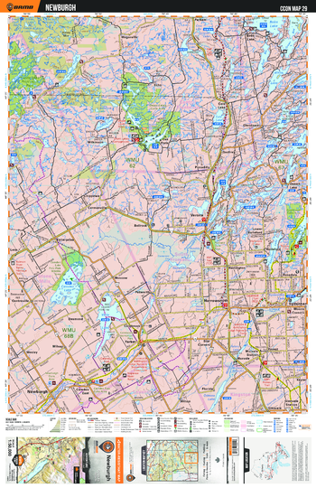
CCON29 Newburgh - Cottage Country Ontario Topo
Backroad Mapbooks
This recreation topographic map for Newburgh highlights all the logging/resource roads, hunting areas, fishing lakes & streams, campsites, paddling routes for canoeing and kayaking, wildlife viewing areas, multi-use trails for hiking, biking, horseback riding, cross-country skiing and snowshoeing, motorized trails for ATVing and snowmobiling & more. Covering 1,090 km2 (420 mi2), this 1:50,000 scale map measures 29 x 38 km (18 x 24 mi), providing you with more topographic and recreational detail for the Richmond Hill area than any other map on the market. New features include enhanced Crown land, countless new roads and trails and a wealth of recreational Points of Interest. Included on this map are Newburgh, Verona, Murvale, Godfrey, Colebrook, Puzzle Lake Provincial Park and more!
Page Size: 24 x 37 in (610 x 940 mm)
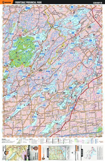
CCON30 Frontenac Provincial Park - Cottage Country Ontario Topo
Backroad Mapbooks
This recreation topographic map for Frontenac Provincial Park highlights all the logging/resource roads, hunting areas, fishing lakes & streams, campsites, paddling routes for canoeing and kayaking, wildlife viewing areas, multi-use trails for hiking, biking, horseback riding, cross-country skiing and snowshoeing, motorized trails for ATVing and snowmobiling & more. Covering 1,090 km2 (420 mi2), this 1:50,000 scale map measures 29 x 38 km (18 x 24 mi), providing you with more topographic and recreational detail for the Richmond Hill area than any other map on the market. New features include enhanced Crown land, countless new roads and trails and a wealth of recreational Points of Interest. Included on this map are Frontenac Provincial Park, Seeleys Bay, Newboro, Salem, Springfield, Spaffordton and more!
Page Size: 24 x 37 in (610 x 940 mm)
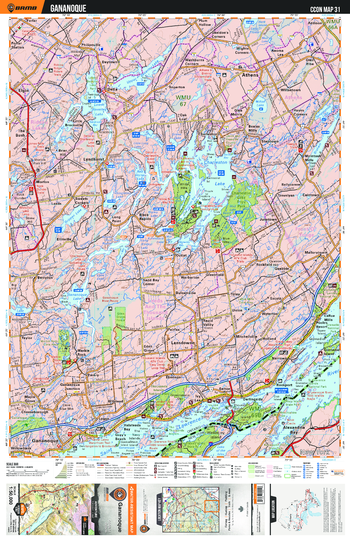
CCON31 Gananoque - Cottage Country Ontario Topo
Backroad Mapbooks
This recreation topographic map for Gananoque highlights all the logging/resource roads, hunting areas, fishing lakes & streams, campsites, paddling routes for canoeing and kayaking, wildlife viewing areas, multi-use trails for hiking, biking, horseback riding, cross-country skiing and snowshoeing, motorized trails for ATVing and snowmobiling & more. Covering 1,090 km2 (420 mi2), this 1:50,000 scale map measures 29 x 38 km (18 x 24 mi), providing you with more topographic and recreational detail for the Richmond Hill area than any other map on the market. New features include enhanced Crown land, countless new roads and trails and a wealth of recreational Points of Interest. Included on this map are Gananoque, Lansdowne, Lyndhurst, Athens, Saint Lawrence River, Mallorytown and more!
Page Size: 24 x 37 in (610 x 940 mm)
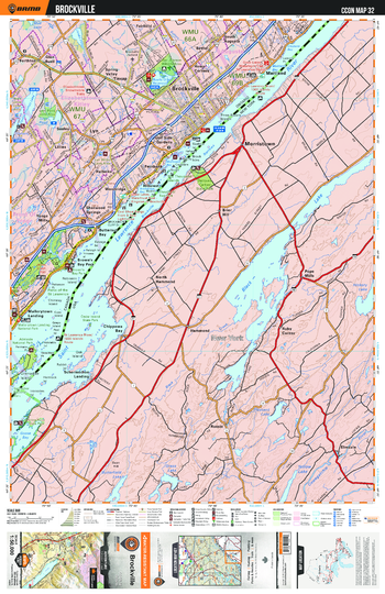
CCON32 Brockville - Cottage Country Ontario Topo
Backroad Mapbooks
This recreation topographic map for Brockville highlights all the logging/resource roads, hunting areas, fishing lakes & streams, campsites, paddling routes for canoeing and kayaking, wildlife viewing areas, multi-use trails for hiking, biking, horseback riding, cross-country skiing and snowshoeing, motorized trails for ATVing and snowmobiling & more. Covering 1,090 km2 (420 mi2), this 1:50,000 scale map measures 29 x 38 km (18 x 24 mi), providing you with more topographic and recreational detail for the Richmond Hill area than any other map on the market. New features include enhanced Crown land, countless new roads and trails and a wealth of recreational Points of Interest. Included on this map are Brockville, Spring Valley, Saint Lawrence River, Yonge Mills, Woodridge, Fairfield, Rows Corners and more!
Page Size: 24 x 37 in (610 x 940 mm)
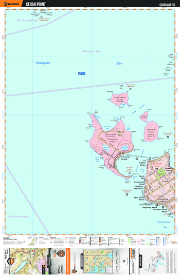
CCON33 Cedar Point - Cottage Country Ontario Topo
Backroad Mapbooks
This recreation topographic map for Cedar Point highlights all the logging/resource roads, hunting areas, fishing lakes & streams, campsites, paddling routes for canoeing and kayaking, wildlife viewing areas, multi-use trails for hiking, biking, horseback riding, cross-country skiing and snowshoeing, motorized trails for ATVing and snowmobiling & more. Covering 1,090 km2 (420 mi2), this 1:50,000 scale map measures 29 x 38 km (18 x 24 mi), providing you with more topographic and recreational detail for the Richmond Hill area than any other map on the market. New features include enhanced Crown land, countless new roads and trails and a wealth of recreational Points of Interest. Included on this map are Cedar Point, Georgian Bay, Beach, Laurin, Kingswood Acres, Georgian Highlands and more!
Page Size: 24 x 37 in (610 x 940 mm)
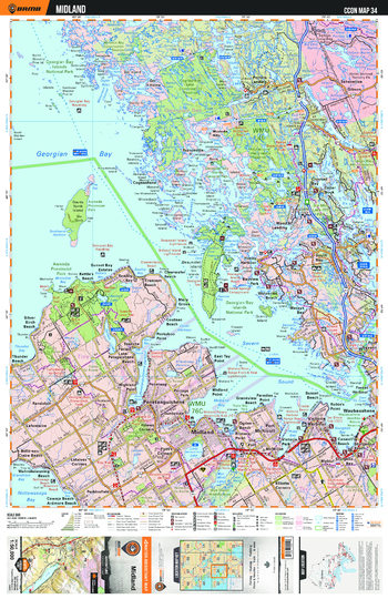
CCON34 Midland - Cottage Country Ontario Topo
Backroad Mapbooks
This recreation topographic map for Midland highlights all the logging/resource roads, hunting areas, fishing lakes & streams, campsites, paddling routes for canoeing and kayaking, wildlife viewing areas, multi-use trails for hiking, biking, horseback riding, cross-country skiing and snowshoeing, motorized trails for ATVing and snowmobiling & more. Covering 1,090 km2 (420 mi2), this 1:50,000 scale map measures 29 x 38 km (18 x 24 mi), providing you with more topographic and recreational detail for the Richmond Hill area than any other map on the market. New features include enhanced Crown land, countless new roads and trails and a wealth of recreational Points of Interest. Included on this map are Midland, Penetanguishene, Georgian Bay, National, Park, Ganaraska Trail, Victoria Harbour and more!
Page Size: 24 x 37 in (610 x 940 mm)
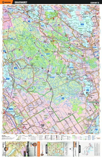
CCON35 Gravenhurst - Cottage Country Ontario Topo
Backroad Mapbooks
This recreation topographic map for Gravenhurst highlights all the logging/resource roads, hunting areas, fishing lakes & streams, campsites, paddling routes for canoeing and kayaking, wildlife viewing areas, multi-use trails for hiking, biking, horseback riding, cross-country skiing and snowshoeing, motorized trails for ATVing and snowmobiling & more. Covering 1,090 km2 (420 mi2), this 1:50,000 scale map measures 29 x 38 km (18 x 24 mi), providing you with more topographic and recreational detail for the Richmond Hill area than any other map on the market. New features include enhanced Crown land, countless new roads and trails and a wealth of recreational Points of Interest. Included on this map are Gravenhurst, Patterson's Landing, Torrance, Maple Valley, Coldwater, Muskoka, Walkers Point and more!
Page Size: 24 x 37 in (610 x 940 mm)
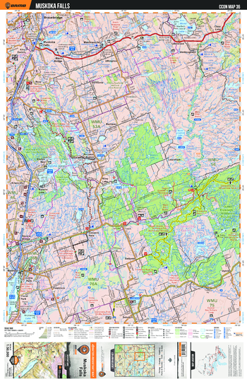
CCON36 Muskoka Falls - Cottage Country Ontario Topo
Backroad Mapbooks
This recreation topographic map for Muskoka Falls highlights all the logging/resource roads, hunting areas, fishing lakes & streams, campsites, paddling routes for canoeing and kayaking, wildlife viewing areas, multi-use trails for hiking, biking, horseback riding, cross-country skiing and snowshoeing, motorized trails for ATVing and snowmobiling & more. Covering 1,090 km2 (420 mi2), this 1:50,000 scale map measures 29 x 38 km (18 x 24 mi), providing you with more topographic and recreational detail for the Richmond Hill area than any other map on the market. New features include enhanced Crown land, countless new roads and trails and a wealth of recreational Points of Interest. Included on this map are Muskoka Falls, Bracebridge, Barkway, Sadowa, Ganaraska Trail, Kahshe Lake and more!
Page Size: 24 x 37 in (610 x 940 mm)
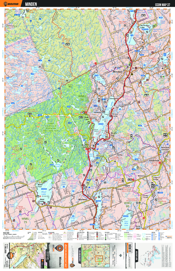
CCON37 Minden - Cottage Country Ontario Topo
Backroad Mapbooks
This recreation topographic map for Minden highlights all the logging/resource roads, hunting areas, fishing lakes & streams, campsites, paddling routes for canoeing and kayaking, wildlife viewing areas, multi-use trails for hiking, biking, horseback riding, cross-country skiing and snowshoeing, motorized trails for ATVing and snowmobiling & more. Covering 1,090 km2 (420 mi2), this 1:50,000 scale map measures 29 x 38 km (18 x 24 mi), providing you with more topographic and recreational detail for the Richmond Hill area than any other map on the market. New features include enhanced Crown land, countless new roads and trails and a wealth of recreational Points of Interest. Included on this map are Minden, Ganaraska Trail, Deep Bay, Kinmount, Norland, Head Lake, Watsons and more!
Page Size: 24 x 37 in (610 x 940 mm)
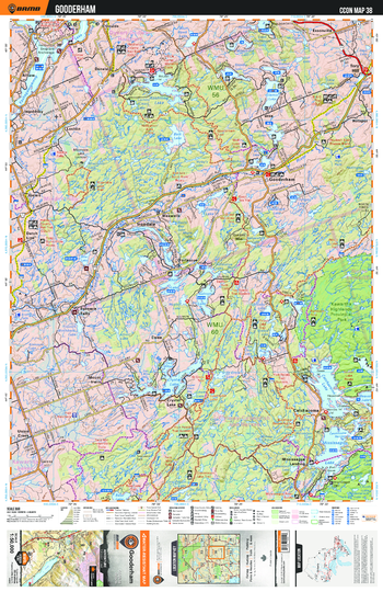
CCON38 Gooderham - Cottage Country Ontario Topo
Backroad Mapbooks
This recreation topographic map for Gooderham highlights all the logging/resource roads, hunting areas, fishing lakes & streams, campsites, paddling routes for canoeing and kayaking, wildlife viewing areas, multi-use trails for hiking, biking, horseback riding, cross-country skiing and snowshoeing, motorized trails for ATVing and snowmobiling & more. Covering 1,090 km2 (420 mi2), this 1:50,000 scale map measures 29 x 38 km (18 x 24 mi), providing you with more topographic and recreational detail for the Richmond Hill area than any other map on the market. New features include enhanced Crown land, countless new roads and trails and a wealth of recreational Points of Interest. Included on this map are Gooderham, Kawartha Highlands Provincial Park, Union Creek, Catchacoma, Crystal Lake, Lochlin and more!
Page Size: 24 x 37 in (610 x 940 mm)
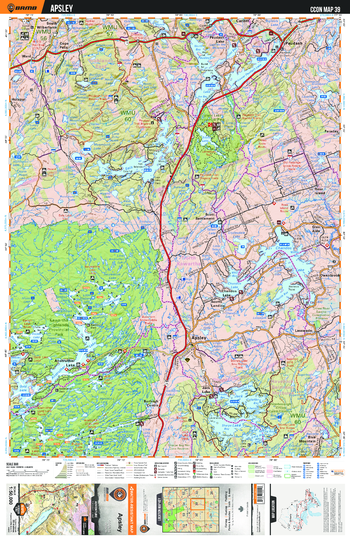
CCON39 Apsley - Cottage Country Ontario Topo
Backroad Mapbooks
This recreation topographic map for Apsley highlights all the logging/resource roads, hunting areas, fishing lakes & streams, campsites, paddling routes for canoeing and kayaking, wildlife viewing areas, multi-use trails for hiking, biking, horseback riding, cross-country skiing and snowshoeing, motorized trails for ATVing and snowmobiling & more. Covering 1,090 km2 (420 mi2), this 1:50,000 scale map measures 29 x 38 km (18 x 24 mi), providing you with more topographic and recreational detail for the Richmond Hill area than any other map on the market. New features include enhanced Crown land, countless new roads and trails and a wealth of recreational Points of Interest. Included on this map are Apsley, Scott Settlement, Kawartha Highlands Provincial Park, Glen Alda, Lasswade, Silent Lake Provincial Park and more!
Page Size: 24 x 37 in (610 x 940 mm)
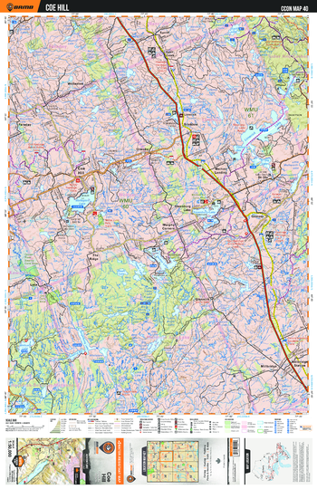
CCON40 Coe Hill - Cottage Country Ontario Topo
Backroad Mapbooks
This recreation topographic map for Coe Hill highlights all the logging/resource roads, hunting areas, fishing lakes & streams, campsites, paddling routes for canoeing and kayaking, wildlife viewing areas, multi-use trails for hiking, biking, horseback riding, cross-country skiing and snowshoeing, motorized trails for ATVing and snowmobiling & more. Covering 1,090 km2 (420 mi2), this 1:50,000 scale map measures 29 x 38 km (18 x 24 mi), providing you with more topographic and recreational detail for the Richmond Hill area than any other map on the market. New features include enhanced Crown land, countless new roads and trails and a wealth of recreational Points of Interest. Included on this map are Coe Hill, Ormsby, Martins Landing, Millbridge, Steenburg Lake, Faraday and more!
Page Size: 24 x 37 in (610 x 940 mm)
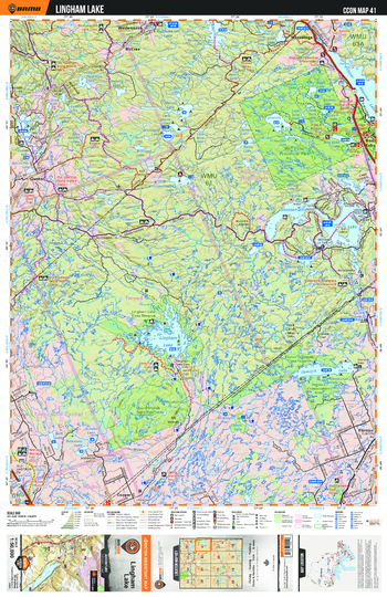
CCON41 Lingham Lake - Cottage Country Ontario Topo
Backroad Mapbooks
This recreation topographic map for Lingham Lake highlights all the logging/resource roads, hunting areas, fishing lakes & streams, campsites, paddling routes for canoeing and kayaking, wildlife viewing areas, multi-use trails for hiking, biking, horseback riding, cross-country skiing and snowshoeing, motorized trails for ATVing and snowmobiling & more. Covering 1,090 km2 (420 mi2), this 1:50,000 scale map measures 29 x 38 km (18 x 24 mi), providing you with more topographic and recreational detail for the Richmond Hill area than any other map on the market. New features include enhanced Crown land, countless new roads and trails and a wealth of recreational Points of Interest. Included on this map are Lingham Lake, Flinton, Bon Echo Provincial Park, Weslemkoon, Cooper, Gunter and more!
Page Size: 24 x 37 in (610 x 940 mm)
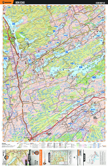
CCON42 Bon Echo - Cottage Country Ontario Topo
Backroad Mapbooks
This recreation topographic map for Bon Echo highlights all the logging/resource roads, hunting areas, fishing lakes & streams, campsites, paddling routes for canoeing and kayaking, wildlife viewing areas, multi-use trails for hiking, biking, horseback riding, cross-country skiing and snowshoeing, motorized trails for ATVing and snowmobiling & more. Covering 1,090 km2 (420 mi2), this 1:50,000 scale map measures 29 x 38 km (18 x 24 mi), providing you with more topographic and recreational detail for the Richmond Hill area than any other map on the market. New features include enhanced Crown land, countless new roads and trails and a wealth of recreational Points of Interest. Included on this map are Bon Echo, Kirk Cove, Arden, Big Gull, Plevna, Kaladar, Flinton and more!
Page Size: 24 x 37 in (610 x 940 mm)
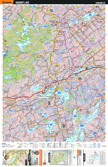
CCON43 Sharbot Lake - Cottage Country Ontario Topo
Backroad Mapbooks
This recreation topographic map for Sharbot Lake highlights all the logging/resource roads, hunting areas, fishing lakes & streams, campsites, paddling routes for canoeing and kayaking, wildlife viewing areas, multi-use trails for hiking, biking, horseback riding, cross-country skiing and snowshoeing, motorized trails for ATVing and snowmobiling & more. Covering 1,090 km2 (420 mi2), this 1:50,000 scale map measures 29 x 38 km (18 x 24 mi), providing you with more topographic and recreational detail for the Richmond Hill area than any other map on the market. New features include enhanced Crown land, countless new roads and trails and a wealth of recreational Points of Interest. Included on this map are Sharbot Lake, Maberly, Zealand, Seouls Corners, Bolingbroke, Kings Falls and more!
Page Size: 24 x 37 in (610 x 940 mm)
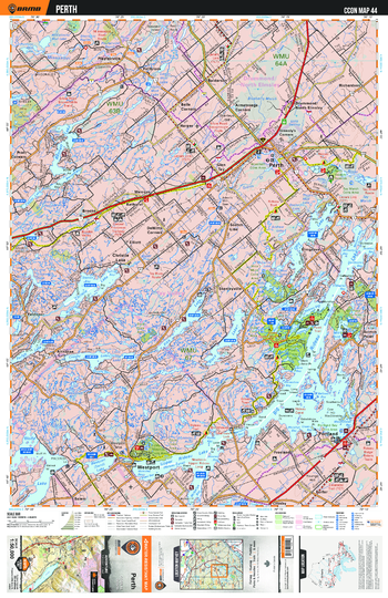
CCON44 Perth - Cottage Country Ontario Topo
Backroad Mapbooks
This recreation topographic map for Perth highlights all the logging/resource roads, hunting areas, fishing lakes & streams, campsites, paddling routes for canoeing and kayaking, wildlife viewing areas, multi-use trails for hiking, biking, horseback riding, cross-country skiing and snowshoeing, motorized trails for ATVing and snowmobiling & more. Covering 1,090 km2 (420 mi2), this 1:50,000 scale map measures 29 x 38 km (18 x 24 mi), providing you with more topographic and recreational detail for the Richmond Hill area than any other map on the market. New features include enhanced Crown land, countless new roads and trails and a wealth of recreational Points of Interest. Included on this map are Perth, Freeland, Christie Lake, Westport, Scotch Line, Portland and more!
Page Size: 24 x 37 in (610 x 940 mm)
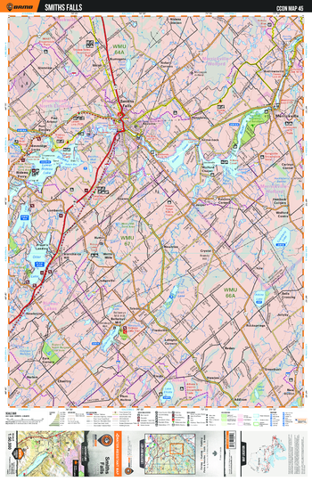
CCON45 Smiths Falls - Cottage Country Ontario Topo
Backroad Mapbooks
This recreation topographic map for Smiths Falls highlights all the logging/resource roads, hunting areas, fishing lakes & streams, campsites, paddling routes for canoeing and kayaking, wildlife viewing areas, multi-use trails for hiking, biking, horseback riding, cross-country skiing and snowshoeing, motorized trails for ATVing and snowmobiling & more. Covering 1,090 km2 (420 mi2), this 1:50,000 scale map measures 29 x 38 km (18 x 24 mi), providing you with more topographic and recreational detail for the Richmond Hill area than any other map on the market. New features include enhanced Crown land, countless new roads and trails and a wealth of recreational Points of Interest. Included on this map are Smiths Falls, Merrickville, New Dublin, Wolflord Chapel, Glenview, Rosedale and more!
Page Size: 24 x 37 in (610 x 940 mm)
No search results