


MapSherpa Catalog
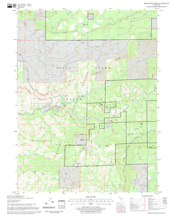
Barkley Mountain Quadrangle, California
United States Department of Agriculture Forest Service
United States Department of Agriculture Forestry Service topographical map of Barkley Mountain, Lassen National Forest, California.
Page Size: 21.75 x 27 in (552 x 686 mm)
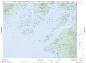
Barkley Sound - 92 C/14 - British Columbia
Natural Resources Canada
Canadian topographic map of Barkley Sound, British Columbia. NTS sheet 092C14 Edition 5.
Page Size: 33.75 x 25.25 in (857 x 638 mm)
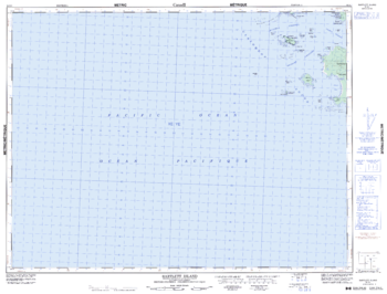
Bartlett Island - 92 E/1 - British Columbia
Natural Resources Canada
Canadian topographic map of Bartlett Island, British Columbia. NTS sheet 092E01 Edition 5.
Page Size: 33.5 x 25.5 in (845 x 643 mm)
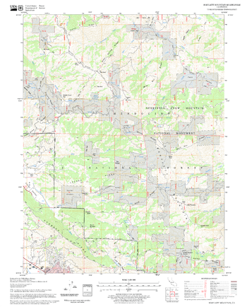
Bartlett Mountain Quadrangle, California
United States Department of Agriculture Forest Service
United States Department of Agriculture Forestry Service topographical map of Bartlett Mountain, Mendocino National Forest, California.
Page Size: 21.75 x 27 in (552 x 686 mm)
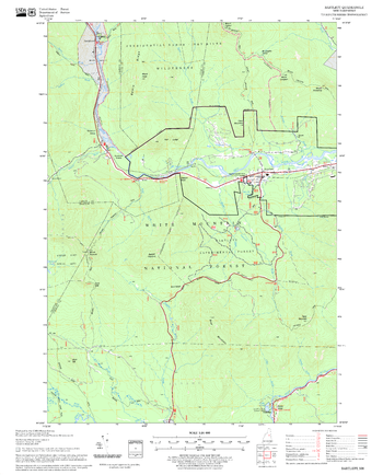
Bartlett Quadrangle, New Hampshire-Vermont
United States Department of Agriculture Forest Service
United States Forestry Service topographical map of Bartlett, New Hampshire-Vermont
Page Size: 21.75 x 27 in (552 x 686 mm)
Bartlett Springs Quadrangle, California
United States Department of Agriculture Forest Service
United States Department of Agriculture Forestry Service topographical map of Bartlett Springs, Mendocino National Forest, California.
Page Size: 21.75 x 27 in (552 x 686 mm)
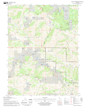
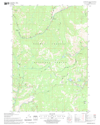
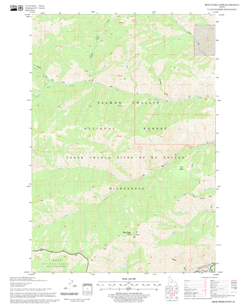
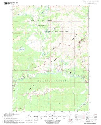
Basin Butte Quadrangle, Idaho
United States Department of Agriculture Forest Service
United States Department of Agriculture Forestry Service topographical map of Basin Butte, Salmon-Chalis National Forest, Idaho.
Page Size: 21.75 x 27 in (552 x 686 mm)

Bath - BA - Postcode Wall Map
XYZ Maps
The Bath Postcode Sector Wall Map shows detailed postcode sector boundaries (BA1 1, BA1 2) on a comprehensive background and is perfect for determining postcode boundaries for sales areas, planning mailshots and also an excellent reference for logistics. This wall map covers the whole of the BA Postcode Area.
Page Size: 47 x 33.25 in (1189 x 841 mm)
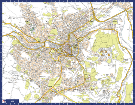
Bath A-Z Street Map
A-Z Maps
The perfect reference map for finding your way around Bath. This up-to-date detailed A-Z town plan includes more than 1,700 streets in and around Bath. Extensive mapping covers an area from Charlcombe in the north to Combe Down in the south, and from Bathampton Down in the east to Whiteway in the west. The highly detailed 1 mile to 4.5 inch street map includes places of interest, among other features.
Page Size: 28.5 x 22.25 in (718 x 560 mm)
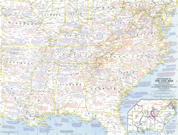
Battlefields of the Civil War - Published 1961
National Geographic
This Civil War map, based on a map upon which General Grant marked his proposed lines of operation, portrays the United States as it was charted in 1863. Published in April 1961 to accompany a map of Civil War battlefields, and the article "The Civil War."
Page Size: 25 x 19 in (633 x 479 mm)
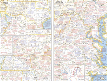
Battlefields of the Civil War Theme - Published 1961
National Geographic
This work features multiple maps of Civil War campaigns, as well as the war's extent in the southwestern United States. Published in April 1961 to accompany a historical map of the Civil War, and the article "The Civil War."
Page Size: 25 x 19 in (633 x 479 mm)
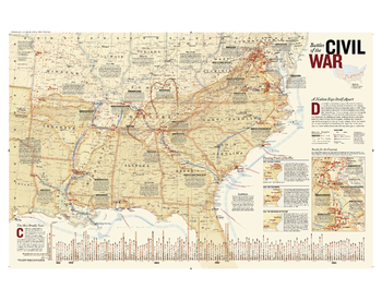
Battles of the Civil War
National Geographic
Created originally as a supplement to the April 2005 National Geographic Magazine, this comprehensive map shows major land campaigns, Union and Confederate troop movements, major Union naval campaigns, roads, railroads, battle outcomes and their impacts on the war, dates of capture by Union forces and more. Two inset maps – Battle for the Capitals and Turning Points of the War – as well as a timeline of battles with map location, casualties and impacts of battles are included. Created with the assistance of the National Park Service, Civil War Preservation Trust, American Battlefield Protection Program, Naval Historical Center, Virginia War Museum, National Museum of Civil War Medicine, and the U.S. Naval Academy.
Page Size: 38 x 30 in (965 x 762 mm)
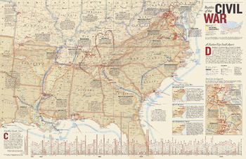
Battles of the Civil War - Published 2005
National Geographic
Determined to preserve a way of life rooted in slavery, 11 southern states declared themselves the independent Confederate States of America in early 1861. President Lincoln asked for 75,000 militiamen to put down this insurrection. The next four years would see three million Americans take up arms against each other, leading to the deaths of at least 620,000 soldiers. This remarkably detailed map of Civil War battles reveals the dates, number of casualties, troop movements, and more in order to gain a better understanding of how this war was fought. Published in April 2005 as half of a two–map set with "A Nation Transformed by Civil War."
Page Size: 31.25 x 20.25 in (790 x 511 mm)
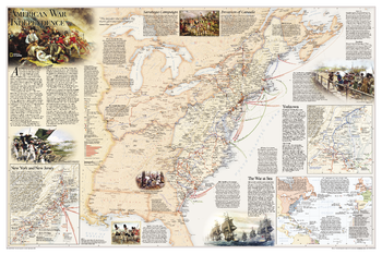
Battles of the Revolutionary War and War of 1812: Side 1
National Geographic
National Geographic's Battles of the Revolutionary War and War of 1812 map is rich with detail, illustrating significant battle sites and routes.<br><br>The map illustrates the American War for Independence fought from 1775-1783, which spread from New England through the Middle Atlantic and into the South. It delineates the boundaries of the British and Spanish territories and the thirteen American colonies as well as the battle sites, which are categorized based on their impact on the war. British Army and Naval bases and the movements of the British, Americans, French, and Spanish forces are also included on the map. Several inset maps are featured, illustrating the War at Sea, and arrival of British forces in New York Harbor in July 1776, and the Battle at Yorktown in 1781. Other key events, including the Saratoga Campaign and the Invasion of Canada, are featured on the map.
Page Size: 36 x 24 in (914 x 610 mm)
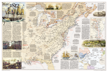
Battles of the Revolutionary War and War of 1812: Side 2
National Geographic
National Geographic's Battles of the Revolutionary War and War of 1812 map is rich with detail, illustrating significant battle sites and routes.<br><br>The map illustrates the War of 1812, which was fought over maritime rights. It delineates the boundaries of the United States, the British territories, and unceded Indian lands, as well as the battle sites, which are categorized based on their impact on the war. British Army and Naval bases and the movements of the British and American forces are also included on the map. Several inset maps are featured, illustrating the Blue Water Naval Engagements and the battles of the Chesapeake, as well as the battles on the Niagra and the Detroit Frontier.
Page Size: 36 x 24 in (914 x 610 mm)
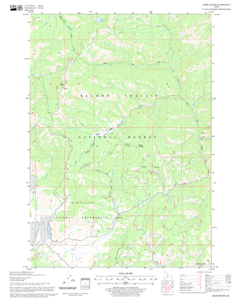
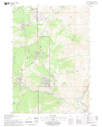
Bayhorse Lake Quadrangle, Idaho
United States Department of Agriculture Forest Service
United States Department of Agriculture Forestry Service topographical map of Bayhorse Lake, Salmon-Chalis National Forest, Idaho.
Page Size: 21.75 x 27 in (552 x 686 mm)
Bayhorse Quadrangle, Idaho
United States Department of Agriculture Forest Service
United States Department of Agriculture Forestry Service topographical map of Bayhorse, Salmon-Chalis National Forest, Idaho.
Page Size: 21.75 x 27 in (552 x 686 mm)
Bear Creek Point Quadrangle, Idaho
United States Department of Agriculture Forest Service
United States Department of Agriculture Forestry Service topographical map of Bear Creek Point, Salmon-Chalis National Forest, Idaho.
Page Size: 21.75 x 27 in (552 x 686 mm)
Bear Valley Mountain Quadrangle, Idaho
United States Department of Agriculture Forest Service
United States Department of Agriculture Forestry Service topographical map of Bear Valley Mountain, Salmon-Chalis National Forest, Idaho.
Page Size: 21.75 x 27 in (552 x 686 mm)
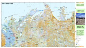
Beaufort Delta Coast
GoTrekkers
Beaufort Delta Coast
Page Size: 40.75 x 22.25 in (1031 x 562 mm)
No search results