


MapSherpa Catalog
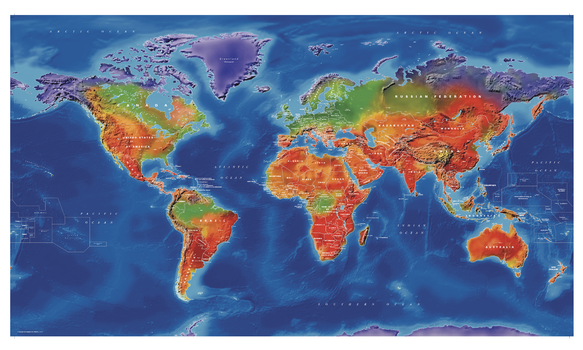
Artistic World Wall Map
Cosmographics
World political mapping and vibrant colours combine to make this beautiful, colourful map with a difference.
Page Size: 39.5 x 22.5 in (999 x 571 mm)
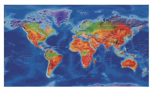
Artistic World Wall Map - Large
Cosmographics
World political mapping and vibrant colours combine to make this beautiful, colourful map with a difference.
Page Size: 53.5 x 30.5 in (1354 x 774 mm)
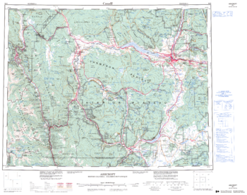
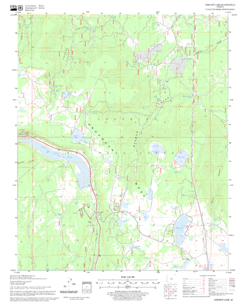
Ashcroft - 92 I - British Columbia
Natural Resources Canada
Canadian topographic map of Ashcroft, British Columbia. NTS sheet 092I Edition 3.
Page Size: 27.75 x 22 in (703 x 554 mm)
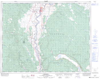
Ashcroft - 92 I/11 - British Columbia
Natural Resources Canada
Canadian topographic map of Ashcroft, British Columbia. NTS sheet 092I11 Edition 3.
Page Size: 32.25 x 25.5 in (815 x 643 mm)
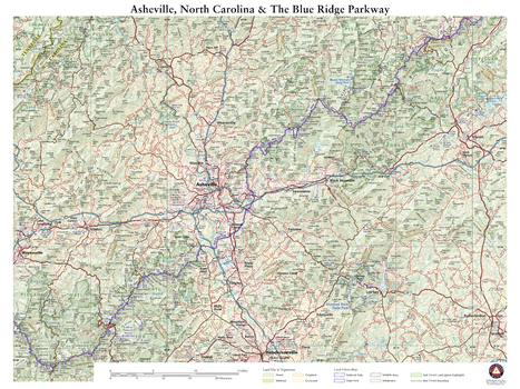
Asheville NC and The Blue Ridge Parkway
Benchmark Maps
This wall map details the terrain and public lands surrounding Asheville, North Carolina. Map features include Mt. Mitchell (highest peak in the eastern U.S.), sections of Pisgah National Forest, several of North Carolina’s state parks, and the segment of the Blue Ridge Parkway between McKinney Gap in the northeast and Richland Balsam Overlook (highest point on BRP) in the southwest.
Page Size: 26 x 34.75 in (660 x 881 mm)
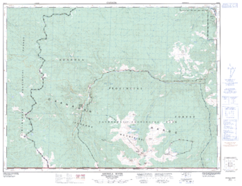
Ashnola River - 92 H/1 - British Columbia
Natural Resources Canada
Canadian topographic map of Ashnola River, British Columbia. NTS sheet 092H01 Edition 2.
Page Size: 33.25 x 25.5 in (842 x 644 mm)
Ashurst Lake Quadrangle, Arizona
United States Department of Agriculture Forest Service
United States Department of Agriculture Forestry Service topographical map of Ashurst Lake, Coconino National Forest, Arizona.
Page Size: 21.75 x 27 in (552 x 686 mm)
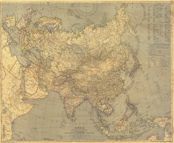
Asia - Published 1933
National Geographic
Collectors will treasure the intricate detail of this ambitious map of Asia. Printed in December 1933 with the article "Afghanistan Makes Haste Slowly," this work features an inset with the names of countries in English and the national language.
Page Size: 37.5 x 30.75 in (950 x 778 mm)
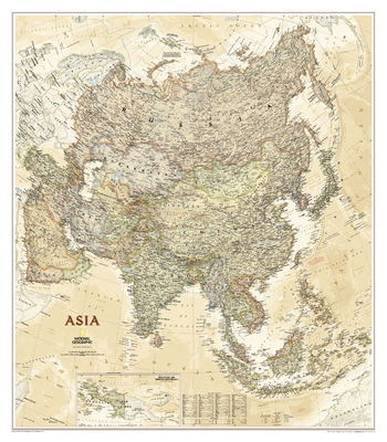
Asia - Published 1971
National Geographic
This vibrant and detailed map of Asia is presented in classic National Geographic style. Of particular note is the attention paid to the oceans, with colorful shading denoting depth and details of currents and prevailing winds. Published in March 1971 to accompany "The Peoples of Mainland Southeast Asia" map and the article "Pagan, on the Road to Mandalay."
Page Size: 32.5 x 37.5 in (824 x 952 mm)
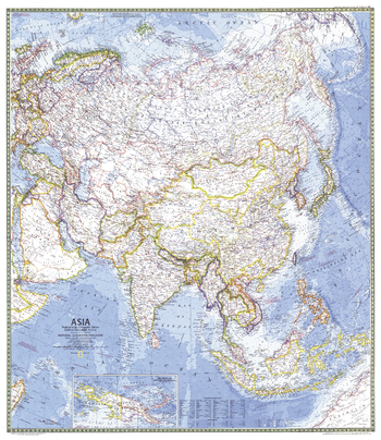
Asia Classic
National Geographic
Detailed National Geographic cartography includes country boundaries, place names, bodies of water, and more for the entire Asian continent.
Page Size: 33.25 x 38 in (845 x 965 mm)
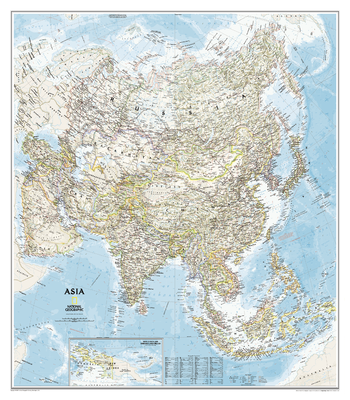
Asia Executive
National Geographic
Detailed National Geographic cartography includes country boundaries, place names, bodies of water, and more for the entire Asian continent.
Page Size: 33.25 x 38 in (845 x 965 mm)
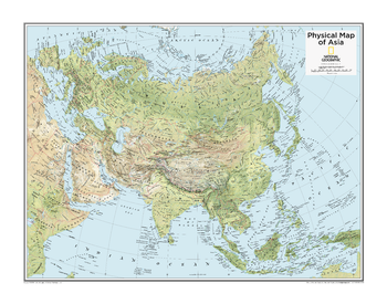
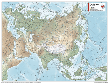
Asia Physical
Maps International
This physical map of Asia features the natural terrain of the land, with countries clearly marked and international borders shown. The map's key helps to identify the land elevation and water depth. This Asia physical map also contains city population detail, capital cities and all the major towns and cities in this continent of Asia.
Asia Physical - Atlas of the World, 10th Edition
National Geographic
null
Page Size: 28 x 22 in (711 x 559 mm)

Asia Physical - Atlas of the World, 11th Edition
National Geographic
This map of physical geography can fit in any space. Showcasing Asia in stunning detail with state-of-the-art cartographic techniques delivering accuracy and exceptional quality, the innovative and engaging design makes the content easily accessible and user-friendly.
Ideal for classrooms with an emphasis on teaching geography or environmental themes. Physical wall maps give your students a genuine feel for how our world appears.
This physical map of Asia uses a bright, easy to read color palette featuring blue oceans and stunning shaded relief that has been featured on National Geographic wall maps for over 75 years. Drawn in the Two-Point Equidistant projection, this map ensures that all points are at proportionally correct distances from two points chosen by the cartographer.
Names of geographic features such as international boundaries, cities, rivers and lakes are carefully placed on the map to maintain legibility.
This map is found in National Geographic's 11th Edition World Atlas and is now available as a stand alone product.
Page Size: 31.5 x 24 in (798 x 610 mm)
Asia Physical - Atlas of the World, 11th Edition - Compact
National Geographic
This map of physical geography can fit in any space. Showcasing Asia in stunning detail with state-of-the-art cartographic techniques delivering accuracy and exceptional quality, the innovative and engaging design makes the content easily accessible and user-friendly.
Ideal for classrooms with an emphasis on teaching geography or environmental themes. Physical wall maps give your students a genuine feel for how our world appears.
This physical map of Asia uses a bright, easy to read color palette featuring blue oceans and stunning shaded relief that has been featured on National Geographic wall maps for over 75 years. Drawn in the Two-Point Equidistant projection, this map ensures that all points are at proportionally correct distances from two points chosen by the cartographer.
Names of geographic features such as international boundaries, cities, rivers and lakes are carefully placed on the map to maintain legibility.
This map is found in National Geographic's 11th Edition World Atlas and is now available as a stand alone product.
Page Size: 21.5 x 16.25 in (540 x 413 mm)
Asia Political
Maps International
This political map of Asia features countries marked in different colours, with international borders clearly shown. This Asia political map also contains city population detail, capital cities and all the major towns and cities in this continent of Asia.
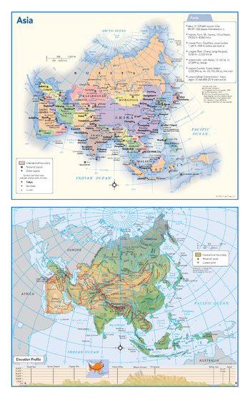
Asia Political & Physical Continent Map
Globe Turner
This map of the Asian continent combines two maps in one - a vivid political map of Asia showing all of the countries and major cities as well as a colorful topographic physical map depicting all of the major physical features in Asia, including a cross-continent elevation profile. The political map includes a call-out box with interesting facts about the continent.
Page Size: 10.75 x 17 in (271 x 432 mm)
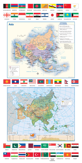
Asia Political & Physical Continent Map with Country Flags
Globe Turner
This map of the Asian continent combines two maps in one - a vivid political map of Asia showing all of the countries and major cities as well as a colorful topographic physical map depicting all of the major physical features in Asia, including a cross-continent elevation profile. The political map includes a call-out box with interesting facts about the continent. The map also includes all 49 flags each Asian country.
Page Size: 11.75 x 23.25 in (298 x 591 mm)
Asia Political - Atlas of the World, 10th Edition
National Geographic
null
Page Size: 28 x 22 in (711 x 559 mm)
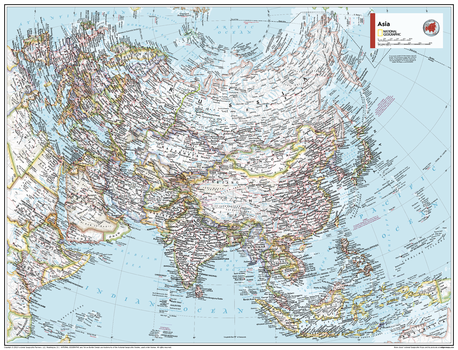
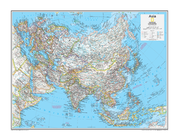
Asia Political - Atlas of the World, 11th Edition
National Geographic
This map of political features can fit in any space. Showcasing Asia in stunning detail with state-of-the-art cartographic techniques delivering accuracy and exceptional quality, the innovative and engaging design makes the content easily accessible and user-friendly.
Ideal for classrooms with an emphasis on teaching geography or environmental themes. The inclusion of physical features to this wall map gives your students a genuine feel for how Asia appears.
This political map of Asia uses a bright, easy to read color palette featuring blue oceans and stunning shaded relief that has been featured on National Geographic wall maps for over 75 years. Drawn in the Two-Point Equidistant projection, this map ensures that all points are at proportionally correct distances from two points chosen by the cartographer.
Names of geographic features such as international boundaries, cities, rivers and lakes are carefully placed on the map to maintain legibility.
This map is found in National Geographic's 11th Edition World Atlas and is now available as a stand alone product.
Page Size: 31.5 x 24 in (798 x 610 mm)
No search results