


MapSherpa Catalog
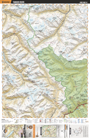
KRBC41 Tangier River - Kootenay Rockies BC Topo
Backroad Mapbooks
This recreation topographic map for the Tangier River area highlights all the logging and resource roads, multi-use trails for hikers, mountain bikers, horseback riders, cross-country skiers and snowshoers, motorized trails for ATVers and snowmobiles, fishing lakes and rivers, recreation areas, campgrounds, day-use areas, viewpoints, backcountry campsites, backcountry huts and cabins and more. No other map for the area provides you with this level of recreational or topographic detail. Special features include private land, labelled fish species and countless roads, trails and recreational Points of Interest. Covering 1,950 km2 (753 mi2), this 1:65,000 scale map measures 38 x 51 km (23.5 x 32 mi). This map includes Glacier National Park, Illecillewaet River, Mount Durrand, Tangier River, Downie Creek, Gold River, Bachelor Creek, Casualty Creek and more!
Page Size: 24 x 37 in (610 x 940 mm)
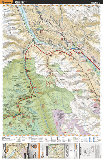
KRBC42 Rogers Pass - Kootenay Rockies BC Topo
Backroad Mapbooks
This recreation topographic map for the Rogers Pass area highlights all the logging and resource roads, multi-use trails for hikers, mountain bikers, horseback riders, cross-country skiers and snowshoers, motorized trails for ATVers and snowmobiles, fishing lakes and rivers, recreation areas, campgrounds, day-use areas, viewpoints, backcountry campsites, backcountry huts and cabins and more. No other map for the area provides you with this level of recreational or topographic detail. Special features include private land, labelled fish species and countless roads, trails and recreational Points of Interest. Covering 1,950 km2 (753 mi2), this 1:65,000 scale map measures 38 x 51 km (23.5 x 32 mi). This map includes Columbia Reach, Columbia River, Redgrave, Stoney Creek, Blaeberry, Glacier National Park, East Gate, Rogers Pass, Dogtooth Range, Beaver River and more!
Page Size: 24 x 37 in (610 x 940 mm)
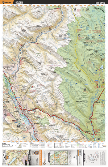
KRBC43 Golden - Kootenay Rockies BC Topo
Backroad Mapbooks
This recreation topographic map for the Golden area highlights all the logging and resource roads, multi-use trails for hikers, mountain bikers, horseback riders, cross-country skiers and snowshoers, motorized trails for ATVers and snowmobiles, fishing lakes and rivers, recreation areas, campgrounds, day-use areas, viewpoints, backcountry campsites, backcountry huts and cabins and more. No other map for the area provides you with this level of recreational or topographic detail. Special features include private land, labelled fish species and countless roads, trails and recreational Points of Interest. Covering 1,950 km2 (753 mi2), this 1:65,000 scale map measures 38 x 51 km (23.5 x 32 mi). This map includes Yoho National Park, Golden, Moberly, Blaeberry, Columbia River, Blaeberry River, Waputik Mtns, Kicking Horse River, Palliser and more!
Page Size: 24 x 37 in (610 x 940 mm)
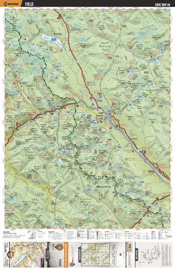
KRBC44 Field - Kootenay Rockies BC Topo
Backroad Mapbooks
This recreation topographic map for the Field area highlights all the logging and resource roads, multi-use trails for hikers, mountain bikers, horseback riders, cross-country skiers and snowshoers, motorized trails for ATVers and snowmobiles, fishing lakes and rivers, recreation areas, campgrounds, day-use areas, viewpoints, backcountry campsites, backcountry huts and cabins and more. No other map for the area provides you with this level of recreational or topographic detail. Special features include private land, labelled fish species and countless roads, trails and recreational Points of Interest. Covering 1,950 km2 (753 mi2), this 1:65,000 scale map measures 38 x 51 km (23.5 x 32 mi). This map includes Banff National Park, Yoho National Park, Hector Lake, Lake Louise, Bow River, Field, Kicking Horse River, Kootenay National Park, Lake McArthur, Boom Lake and more!
Page Size: 24 x 37 in (610 x 940 mm)
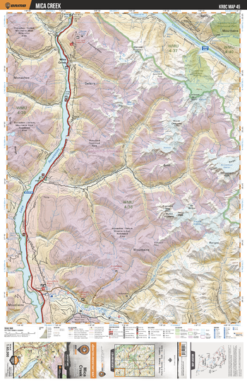
KRBC45 Mica Creek - Kootenay Rockies BC Topo
Backroad Mapbooks
This recreation topographic map for the Mica Creek area highlights all the logging and resource roads, multi-use trails for hikers, mountain bikers, horseback riders, cross-country skiers and snowshoers, motorized trails for ATVers and snowmobiles, fishing lakes and rivers, recreation areas, campgrounds, day-use areas, viewpoints, backcountry campsites, backcountry huts and cabins and more. No other map for the area provides you with this level of recreational or topographic detail. Special features include private land, labelled fish species and countless roads, trails and recreational Points of Interest. Covering 1,950 km2 (753 mi2), this 1:65,000 scale map measures 38 x 51 km (23.5 x 32 mi). This map includes Lake Revelstoke, Columbia Reach, Mica Creek, Goldstream River, Bigmouth Creek, Gorge Lake, Escarpment Glacier, French Creek, Goosegrass Ecological Reserve, Cummins Lake Prov Park and more!
Page Size: 24 x 37 in (610 x 940 mm)
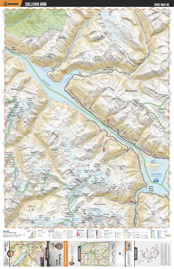
KRBC46 Sullivan Arm - Kootenay Rockies BC Topo
Backroad Mapbooks
This recreation topographic map for the Sullivan Arm area highlights all the logging and resource roads, multi-use trails for hikers, mountain bikers, horseback riders, cross-country skiers and snowshoers, motorized trails for ATVers and snowmobiles, fishing lakes and rivers, recreation areas, campgrounds, day-use areas, viewpoints, backcountry campsites, backcountry huts and cabins and more. No other map for the area provides you with this level of recreational or topographic detail. Special features include private land, labelled fish species and countless roads, trails and recreational Points of Interest. Covering 1,950 km2 (753 mi2), this 1:65,000 scale map measures 38 x 51 km (23.5 x 32 mi). This map includes Kinbasket (McNaughton) Lake, Columbia Reach, Sullivan Arm, Sullivan River Camp, Sullivan River, Cummins Lake Prov Park, Fairy Meadow, Gold River Camp, Tsar Camp, Kinbasket River and more!
Page Size: 24 x 37 in (610 x 940 mm)
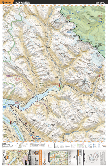
KRBC47 Bush Harbour - Kootenay Rockies BC Topo
Backroad Mapbooks
This recreation topographic map for the Bush Harbour area highlights all the logging and resource roads, multi-use trails for hikers, mountain bikers, horseback riders, cross-country skiers and snowshoers, motorized trails for ATVers and snowmobiles, fishing lakes and rivers, recreation areas, campgrounds, day-use areas, viewpoints, backcountry campsites, backcountry huts and cabins and more. No other map for the area provides you with this level of recreational or topographic detail. Special features include private land, labelled fish species and countless roads, trails and recreational Points of Interest. Covering 1,950 km2 (753 mi2), this 1:65,000 scale map measures 38 x 51 km (23.5 x 32 mi). This map includes Banff National Park, Bush Arm, Bush Harbour, Kinbasket Lake, Columbia Reach, Bluewater Creek, Bush River, Camp David, Bush River Camp, Valenciennes River, Hope Creek and more!
Page Size: 24 x 37 in (610 x 940 mm)
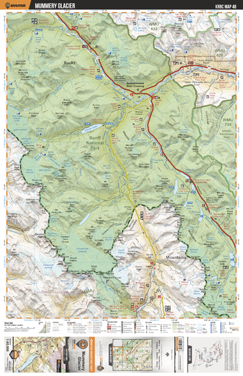
KRBC48 Mummery Glacier - Kootenay Rockies BC Topo
Backroad Mapbooks
This recreation topographic map for the Mummery Glacier area highlights all the logging and resource roads, multi-use trails for hikers, mountain bikers, horseback riders, cross-country skiers and snowshoers, motorized trails for ATVers and snowmobiles, fishing lakes and rivers, recreation areas, campgrounds, day-use areas, viewpoints, backcountry campsites, backcountry huts and cabins and more. No other map for the area provides you with this level of recreational or topographic detail. Special features include private land, labelled fish species and countless roads, trails and recreational Points of Interest. Covering 1,950 km2 (753 mi2), this 1:65,000 scale map measures 38 x 51 km (23.5 x 32 mi). This map includes Banff National Park, Glacier Lake, North Saskatchewan River, Peyto Lake, Blaeberry River, Mummery Glacier, Mistaya River, Alexandra River, Waputik Mtns, Chepren Lake and more!
Page Size: 24 x 37 in (610 x 940 mm)
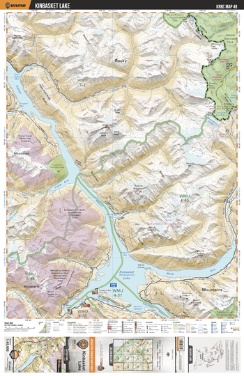
KRBC49 Kinbasket Lake - Kootenay Rockies BC Topo
Backroad Mapbooks
This recreation topographic map for the Kinbasket Lake area highlights all the logging and resource roads, multi-use trails for hikers, mountain bikers, horseback riders, cross-country skiers and snowshoers, motorized trails for ATVers and snowmobiles, fishing lakes and rivers, recreation areas, campgrounds, day-use areas, viewpoints, backcountry campsites, backcountry huts and cabins and more. No other map for the area provides you with this level of recreational or topographic detail. Special features include private land, labelled fish species and countless roads, trails and recreational Points of Interest. Covering 1,950 km2 (753 mi2), this 1:65,000 scale map measures 38 x 51 km (23.5 x 32 mi). This map includes Kinbasket Lake, Wood Arm, Canoe Reach, Columbia Reach, Sprague Bay, Foster Arm, Jasper National Park, Hugh Allan Creek, Mount Cummins, Hugh Allan Bay and more!
Page Size: 24 x 37 in (610 x 940 mm)
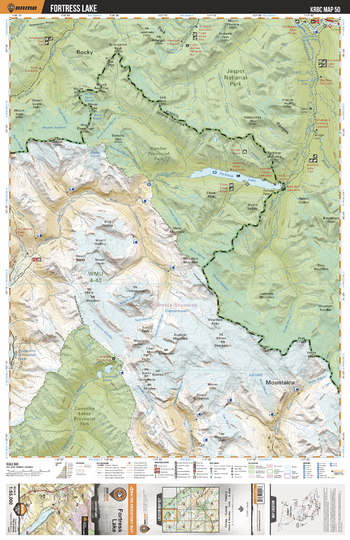
KRBC50 Fortress Lake - Kootenay Rockies BC Topo
Backroad Mapbooks
This recreation topographic map for the Fortress Lake area highlights all the logging and resource roads, multi-use trails for hikers, mountain bikers, horseback riders, cross-country skiers and snowshoers, motorized trails for ATVers and snowmobiles, fishing lakes and rivers, recreation areas, campgrounds, day-use areas, viewpoints, backcountry campsites, backcountry huts and cabins and more. No other map for the area provides you with this level of recreational or topographic detail. Special features include private land, labelled fish species and countless roads, trails and recreational Points of Interest. Covering 1,950 km2 (753 mi2), this 1:65,000 scale map measures 38 x 51 km (23.5 x 32 mi). This map includes Jasper National Park, Cummins Lake Prov Park, Fortress Lake, Sullivan River, Chaba River, Chisel Creek, Hamber Prov Park, Whirlpool River, Wood River, Cummins Lakes and more!
Page Size: 24 x 37 in (610 x 940 mm)
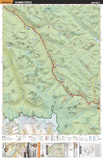
KRBC51 Columbia Icefield - Kootenay Rockies BC Topo
Backroad Mapbooks
This recreation topographic map for the Columbia Icefield area highlights all the logging and resource roads, multi-use trails for hikers, mountain bikers, horseback riders, cross-country skiers and snowshoers, motorized trails for ATVers and snowmobiles, fishing lakes and rivers, recreation areas, campgrounds, day-use areas, viewpoints, backcountry campsites, backcountry huts and cabins and more. No other map for the area provides you with this level of recreational or topographic detail. Special features include private land, labelled fish species and countless roads, trails and recreational Points of Interest. Covering 1,950 km2 (753 mi2), this 1:65,000 scale map measures 38 x 51 km (23.5 x 32 mi). This map includes Jasper National Park, Banff National Park, Mount Columbia, Athabasca River, Jonas Shoulder, Poboktan Creek, Brazeau Lake, Sunwapta Lake, Columbia Icefield, Sunwapta River and more!
Page Size: 24 x 37 in (610 x 940 mm)
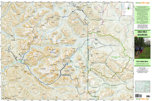
Kakwa Provincial Park & Wildland Area
GoTrekkers
Kakwa Provincial Park & Wildland Area
Page Size: 40.5 x 27 in (1029 x 686 mm)
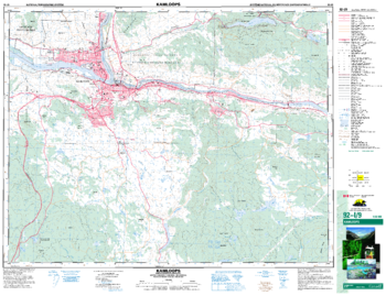
Kamloops - 92 I/9 - British Columbia
Natural Resources Canada
Canadian topographic map of Kamloops, British Columbia. NTS sheet 092I09 Edition 5.
Page Size: 34 x 26 in (858 x 659 mm)
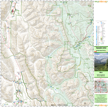
Kananaskis Central
GoTrekkers
Kananaskis Central
Page Size: 33.75 x 33.25 in (854 x 841 mm)
Kananaskis NE
GoTrekkers
Kananaskis NE
Page Size: 41 x 34.5 in (1041 x 876 mm)
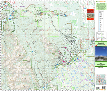
Kananaskis NW
GoTrekkers
Kananaskis NW
Page Size: 39 x 32.5 in (991 x 826 mm)
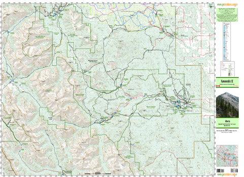
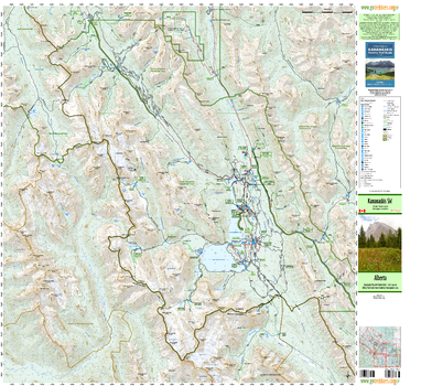
Kananaskis SE
GoTrekkers
Kananaskis SE
Page Size: 46 x 33.5 in (1168 x 851 mm)
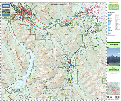
Kananaskis SW
GoTrekkers
Kananaskis SW
Page Size: 41.5 x 38 in (1054 x 965 mm)
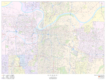
Kansas City, Missouri Inner Metro - Landscape
MapSherpa
This landscape-oriented map of central Kansas City, Missouri shows detailed street level information including extensive street labeling. Ideal for planning of deliveries, home services, sales territories, real estate and much more. Base map features include all roads with major roads and highways labelled; neighborhood names; railways; high level land use such as parks and recreation areas, industrial areas and hospital campuses; and a variety of points of interest including schools, libraries, stadiums, museums, border crossings and more.
Page Size: 48 x 36 in (1219 x 914 mm)
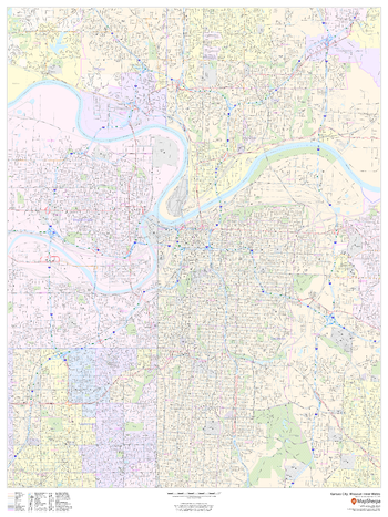
Kansas City, Missouri Inner Metro - Portrait
MapSherpa
This portrait-oriented map of central Kansas City, Missouri shows detailed street level information including extensive street labeling. Ideal for planning of deliveries, home services, sales territories, real estate and much more. Base map features include all roads with major roads and highways labelled; neighborhood names; railways; high level land use such as parks and recreation areas, industrial areas and hospital campuses; and a variety of points of interest including schools, libraries, stadiums, museums, border crossings and more.
Page Size: 36 x 48 in (914 x 1219 mm)
No search results