


MapSherpa Catalog
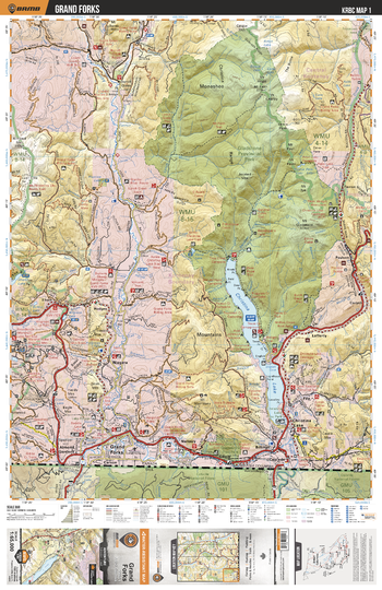
KRBC01 Grand Forks - Kootenay Rockies BC Topo BC Topo
Backroad Mapbooks
This recreation topographic map for the Grand Forks area highlights all the logging and resource roads, multi-use trails for hikers, mountain bikers, horseback riders, cross-country skiers and snowshoers, motorized trails for ATVers and snowmobiles, fishing lakes and rivers, recreation areas, campgrounds, day-use areas, viewpoints, backcountry campsites, backcountry huts and cabins and more. No other map for the area provides you with this level of recreational or topographic detail. Special features include private land, labelled fish species and countless roads, trails and recreational Points of Interest. Covering 1,950 km2 (753 mi2), this 1:65,000 scale map measures 38 x 51 km (23.5 x 32 mi). This map includes Cascade, Christina Lake, Eholt, Fife, Gladstone Provincial Park, Granby River, Grand Forks, Kettle River, Marshall Lake, Paulson, Phoenix Mountain, Rock Candy Mine, Xenia Lake and more!
Page Size: 24 x 37 in (610 x 940 mm)
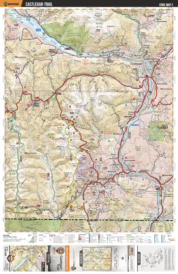
KRBC02 Castlegar Trail - Kootenay Rockies BC Topo
Backroad Mapbooks
This recreation topographic map for the Castlegar Trail area highlights all the logging and resource roads, multi-use trails for hikers, mountain bikers, horseback riders, cross-country skiers and snowshoers, motorized trails for ATVers and snowmobiles, fishing lakes and rivers, recreation areas, campgrounds, day-use areas, viewpoints, backcountry campsites, backcountry huts and cabins and more. No other map for the area provides you with this level of recreational or topographic detail. Special features include private land, labelled fish species and countless roads, trails and recreational Points of Interest. Covering 1,950 km2 (753 mi2), this 1:65,000 scale map measures 38 x 51 km (23.5 x 32 mi). This map includes Lower Arrow Lake, Columbia River, Castlegar, Trail, Montrose, Rossland, Nancy Greene Lake, Champion Lakes, Deer park, Syringa Creek Prov Park, Mount St Thomas and more!
Page Size: 24 x 37 in (610 x 940 mm)
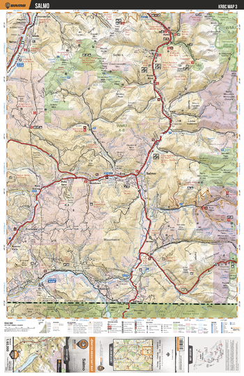
KRBC03 Salmo - Kootenay Rockies BC Topo BC Topo
Backroad Mapbooks
This recreation topographic map for the Salmo BC Topo area highlights all the logging and resource roads, multi-use trails for hikers, mountain bikers, horseback riders, cross-country skiers and snowshoers, motorized trails for ATVers and snowmobiles, fishing lakes and rivers, recreation areas, campgrounds, day-use areas, viewpoints, backcountry campsites, backcountry huts and cabins and more. No other map for the area provides you with this level of recreational or topographic detail. Special features include private land, labelled fish species and countless roads, trails and recreational Points of Interest. Covering 1,950 km2 (753 mi2), this 1:65,000 scale map measures 38 x 51 km (23.5 x 32 mi). This map includes Salmo, Darkwoods National Wildlife Area, Pend d'Oreille River, Erie, Kootenay River, Toad Mtn, Yellowstone Peak, Fruitvale, Siwash Mtn, Mount Elise and more!
Page Size: 24 x 37 in (610 x 940 mm)
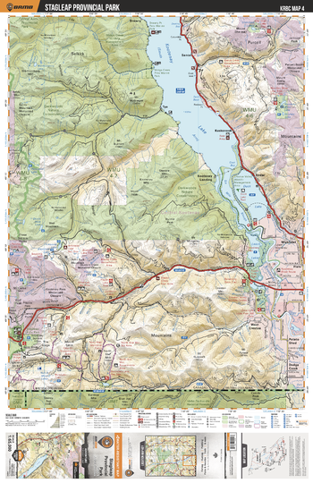
KRBC04 Stagleap Provincial Park - Kootenay Rockies BC Topo
Backroad Mapbooks
This recreation topographic map for the Stagleap Provincial Park area highlights all the logging and resource roads, multi-use trails for hikers, mountain bikers, horseback riders, cross-country skiers and snowshoers, motorized trails for ATVers and snowmobiles, fishing lakes and rivers, recreation areas, campgrounds, day-use areas, viewpoints, backcountry campsites, backcountry huts and cabins and more. No other map for the area provides you with this level of recreational or topographic detail. Special features include private land, labelled fish species and countless roads, trails and recreational Points of Interest. Covering 1,950 km2 (753 mi2), this 1:65,000 scale map measures 38 x 51 km (23.5 x 32 mi). This map includes Kootenay Lake, Darkwoods National Wildlife Area, Wynndel, Stagleap Prov Park, Leach Lake, Six Mile Slough, Dodge Creek, Duck Lake, Drewry, Kuskonook and more!
Page Size: 24 x 37 in (610 x 940 mm)
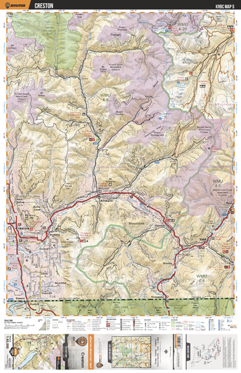
KRBC05 Creston - Kootenay Rockies BC Topo
Backroad Mapbooks
This recreation topographic map for the Creston area highlights all the logging and resource roads, multi-use trails for hikers, mountain bikers, horseback riders, cross-country skiers and snowshoers, motorized trails for ATVers and snowmobiles, fishing lakes and rivers, recreation areas, campgrounds, day-use areas, viewpoints, backcountry campsites, backcountry huts and cabins and more. No other map for the area provides you with this level of recreational or topographic detail. Special features include private land, labelled fish species and countless roads, trails and recreational Points of Interest. Covering 1,950 km2 (753 mi2), this 1:65,000 scale map measures 38 x 51 km (23.5 x 32 mi). This map includes Kianuko Prov Park, Kitchener, Yahk, Creston, Cranbrook Area Snowmobile Restriction Area, Cooper Lake, Moyie River, Goat River, Goatfell, Glenlily and more!
Page Size: 24 x 37 in (610 x 940 mm)
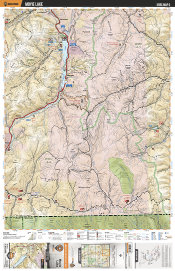
KRBC06 Moyie Lake - Kootenay Rockies BC Topo
Backroad Mapbooks
This recreation topographic map for the Moyie Lake area highlights all the logging and resource roads, multi-use trails for hikers, mountain bikers, horseback riders, cross-country skiers and snowshoers, motorized trails for ATVers and snowmobiles, fishing lakes and rivers, recreation areas, campgrounds, day-use areas, viewpoints, backcountry campsites, backcountry huts and cabins and more. No other map for the area provides you with this level of recreational or topographic detail. Special features include private land, labelled fish species and countless roads, trails and recreational Points of Interest. Covering 1,950 km2 (753 mi2), this 1:65,000 scale map measures 38 x 51 km (23.5 x 32 mi). This map includes Moyie Lake, Gilnockie Prov Park, Moyie River, Cherry Lake, Swansea, Moyie, Yahk Range, Tochty, Ryan, Gilnockie Creek and more!
Page Size: 24 x 37 in (610 x 940 mm)
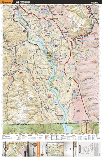
KRBC07 Lake Koocanusa - Kootenay Rockies BC Topo
Backroad Mapbooks
This recreation topographic map for the Lake Koocanusa area highlights all the logging and resource roads, multi-use trails for hikers, mountain bikers, horseback riders, cross-country skiers and snowshoers, motorized trails for ATVers and snowmobiles, fishing lakes and rivers, recreation areas, campgrounds, day-use areas, viewpoints, backcountry campsites, backcountry huts and cabins and more. No other map for the area provides you with this level of recreational or topographic detail. Special features include private land, labelled fish species and countless roads, trails and recreational Points of Interest. Covering 1,950 km2 (753 mi2), this 1:65,000 scale map measures 38 x 51 km (23.5 x 32 mi). This map includes Kootenay River, Lake Koocanusa, Baynes Lake, Kragmont, Elko, Jaffray, Wardner, Mount Broadwood Heritage Conservation Area, Lizard Range, Morrissey and more!
Page Size: 24 x 37 in (610 x 940 mm)
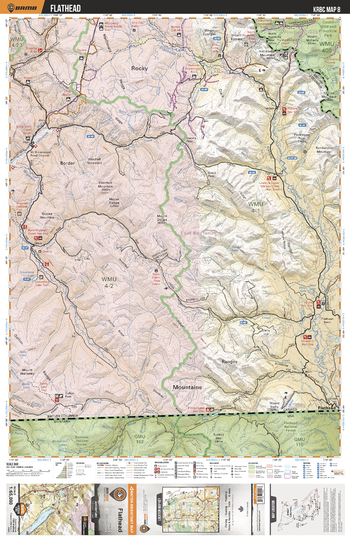
KRBC08 Flathead - Kootenay Rockies BC Topo
Backroad Mapbooks
This recreation topographic map for the Flathead area highlights all the logging and resource roads, multi-use trails for hikers, mountain bikers, horseback riders, cross-country skiers and snowshoers, motorized trails for ATVers and snowmobiles, fishing lakes and rivers, recreation areas, campgrounds, day-use areas, viewpoints, backcountry campsites, backcountry huts and cabins and more. No other map for the area provides you with this level of recreational or topographic detail. Special features include private land, labelled fish species and countless roads, trails and recreational Points of Interest. Covering 1,950 km2 (753 mi2), this 1:65,000 scale map measures 38 x 51 km (23.5 x 32 mi). This map includes Mount Broadwood Heritage Conservation Area, Castle Special Management Area, Flathead River, Snowshoe Lake, Flathead, Hellebeke Mtn and more!
Page Size: 24 x 37 in (610 x 940 mm)
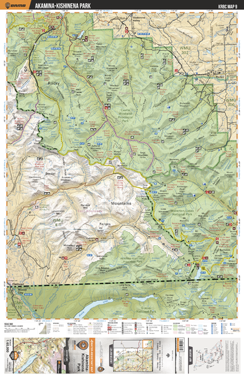
KRBC09 Akamina Kishinena Park - Kootenay Rockies BC Topo
Backroad Mapbooks
This recreation topographic map for the Akamina Kishinena Park area highlights all the logging and resource roads, multi-use trails for hikers, mountain bikers, horseback riders, cross-country skiers and snowshoers, motorized trails for ATVers and snowmobiles, fishing lakes and rivers, recreation areas, campgrounds, day-use areas, viewpoints, backcountry campsites, backcountry huts and cabins and more. No other map for the area provides you with this level of recreational or topographic detail. Special features include private land, labelled fish species and countless roads, trails and recreational Points of Interest. Covering 1,950 km2 (753 mi2), this 1:65,000 scale map measures 38 x 51 km (23.5 x 32 mi). This map includes Castle Special Management Area, Pecten, Waterton Lakes National Park, Akamina-Kishinena Prov Park, Akaminia Lake, Cameron Lake, Beaver Mines Lake, Castle River, Kishinena Creek and more!
Page Size: 24 x 37 in (610 x 940 mm)
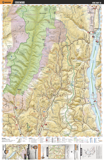
KRBC10 Edgewood - Kootenay Rockies BC Topo
Backroad Mapbooks
This recreation topographic map for the Edgewood area highlights all the logging and resource roads, multi-use trails for hikers, mountain bikers, horseback riders, cross-country skiers and snowshoers, motorized trails for ATVers and snowmobiles, fishing lakes and rivers, recreation areas, campgrounds, day-use areas, viewpoints, backcountry campsites, backcountry huts and cabins and more. No other map for the area provides you with this level of recreational or topographic detail. Special features include private land, labelled fish species and countless roads, trails and recreational Points of Interest. Covering 1,950 km2 (753 mi2), this 1:65,000 scale map measures 38 x 51 km (23.5 x 32 mi). This map includes Granby Prov Park, Lower Arrow Lake, Bluejoint Mtn, Granby River, Renata, Edgewood, Mount Carleton Brown, Burns Lake, Eagle Creek and more!
Page Size: 24 x 37 in (610 x 940 mm)
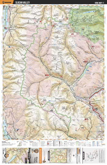
KRBC11 Slocan Valley - Kootenay Rockies BC Topo
Backroad Mapbooks
This recreation topographic map for the Slocan Valley area highlights all the logging and resource roads, multi-use trails for hikers, mountain bikers, horseback riders, cross-country skiers and snowshoers, motorized trails for ATVers and snowmobiles, fishing lakes and rivers, recreation areas, campgrounds, day-use areas, viewpoints, backcountry campsites, backcountry huts and cabins and more. No other map for the area provides you with this level of recreational or topographic detail. Special features include private land, labelled fish species and countless roads, trails and recreational Points of Interest. Covering 1,950 km2 (753 mi2), this 1:65,000 scale map measures 38 x 51 km (23.5 x 32 mi). This map includes Slocan Park, Slocan River, Upper Little Slocan Lake, Lower Little Slocan Lake, Lower Arrow Lake, Evans Lake, Valhalla Prov Park, Lebahdo, Applegrove, Mt McKean and more!
Page Size: 24 x 37 in (610 x 940 mm)
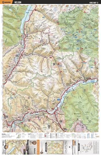
KRBC12 Nelson - Kootenay Rockies BC Topo
Backroad Mapbooks
This recreation topographic map for the Nelson area highlights all the logging and resource roads, multi-use trails for hikers, mountain bikers, horseback riders, cross-country skiers and snowshoers, motorized trails for ATVers and snowmobiles, fishing lakes and rivers, recreation areas, campgrounds, day-use areas, viewpoints, backcountry campsites, backcountry huts and cabins and more. No other map for the area provides you with this level of recreational or topographic detail. Special features include private land, labelled fish species and countless roads, trails and recreational Points of Interest. Covering 1,950 km2 (753 mi2), this 1:65,000 scale map measures 38 x 51 km (23.5 x 32 mi). This map includes Nelson, Kootenay River, West Arm, Morning Mtn, Kokanee Creek Prov Park, West Arm Prov Park, Kokanee Glacier Prov Park, Valhalla Prov Park, Slocan Lake, Slocan River and more!
Page Size: 24 x 37 in (610 x 940 mm)
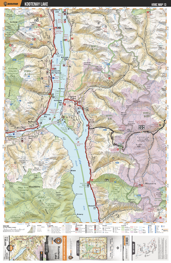
KRBC13 Kootenay Lake - Kootenay Rockies BC Topo
Backroad Mapbooks
This recreation topographic map for the Kootenay Lake area highlights all the logging and resource roads, multi-use trails for hikers, mountain bikers, horseback riders, cross-country skiers and snowshoers, motorized trails for ATVers and snowmobiles, fishing lakes and rivers, recreation areas, campgrounds, day-use areas, viewpoints, backcountry campsites, backcountry huts and cabins and more. No other map for the area provides you with this level of recreational or topographic detail. Special features include private land, labelled fish species and countless roads, trails and recreational Points of Interest. Covering 1,950 km2 (753 mi2), this 1:65,000 scale map measures 38 x 51 km (23.5 x 32 mi). This map includes Kootenay Lake, Lockhart Creek Prov Park, West Arm Prov Park, Kokanee Glacier Prov Park, Gray Creek, Cody Caves Prov Park, Balfour, Riondell, Ainsworth Hot Springs, Mirror Lake and more!
Page Size: 24 x 37 in (610 x 940 mm)
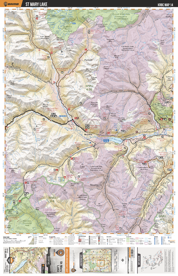
KRBC14 St Mary Lake - Kootenay Rockies BC Topo
Backroad Mapbooks
This recreation topographic map for the St Mary Lake area highlights all the logging and resource roads, multi-use trails for hikers, mountain bikers, horseback riders, cross-country skiers and snowshoers, motorized trails for ATVers and snowmobiles, fishing lakes and rivers, recreation areas, campgrounds, day-use areas, viewpoints, backcountry campsites, backcountry huts and cabins and more. No other map for the area provides you with this level of recreational or topographic detail. Special features include private land, labelled fish species and countless roads, trails and recreational Points of Interest. Covering 1,950 km2 (753 mi2), this 1:65,000 scale map measures 38 x 51 km (23.5 x 32 mi). This map includes Kianuko Prov Park, St Mary Lake, St Mary's Alpine Prov Park, Purcell Wilderness Conservancy Prov Park, Puddingburn Mtn, Mount Evans, Dipper Lake, Bootleg Mtn, Meachen, St Mary River and more!
Page Size: 24 x 37 in (610 x 940 mm)
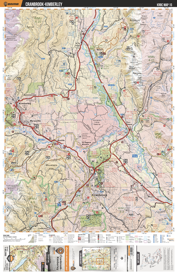
KRBC15 Cranbrook Kimberley - Kootenay Rockies BC Topo
Backroad Mapbooks
This recreation topographic map for the Cranbrook Kimberley area highlights all the logging and resource roads, multi-use trails for hikers, mountain bikers, horseback riders, cross-country skiers and snowshoers, motorized trails for ATVers and snowmobiles, fishing lakes and rivers, recreation areas, campgrounds, day-use areas, viewpoints, backcountry campsites, backcountry huts and cabins and more. No other map for the area provides you with this level of recreational or topographic detail. Special features include private land, labelled fish species and countless roads, trails and recreational Points of Interest. Covering 1,950 km2 (753 mi2), this 1:65,000 scale map measures 38 x 51 km (23.5 x 32 mi). This map includes Kimberley, Cranbrook, Fort Steele, Wasa, Kootenay River, Lazy Lake, Echo Lakes, Lumberton, Wycliffe, Marysville and more!
Page Size: 24 x 37 in (610 x 940 mm)
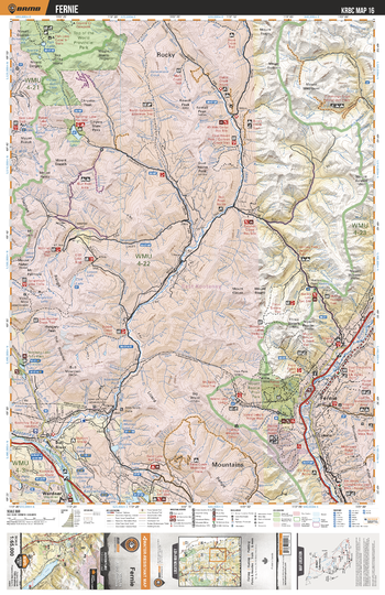
KRBC16 Fernie - Kootenay Rockies BC Topo
Backroad Mapbooks
This recreation topographic map for the Fernie area highlights all the logging and resource roads, multi-use trails for hikers, mountain bikers, horseback riders, cross-country skiers and snowshoers, motorized trails for ATVers and snowmobiles, fishing lakes and rivers, recreation areas, campgrounds, day-use areas, viewpoints, backcountry campsites, backcountry huts and cabins and more. No other map for the area provides you with this level of recreational or topographic detail. Special features include private land, labelled fish species and countless roads, trails and recreational Points of Interest. Covering 1,950 km2 (753 mi2), this 1:65,000 scale map measures 38 x 51 km (23.5 x 32 mi). This map includes Top of the World Prov Park, Fish Lake, Elk River, Bull River, Fernie, Hartley Lake, Cummings Creek, Mount Procter, Wardner, Tanglefoot Lake and more!
Page Size: 24 x 37 in (610 x 940 mm)
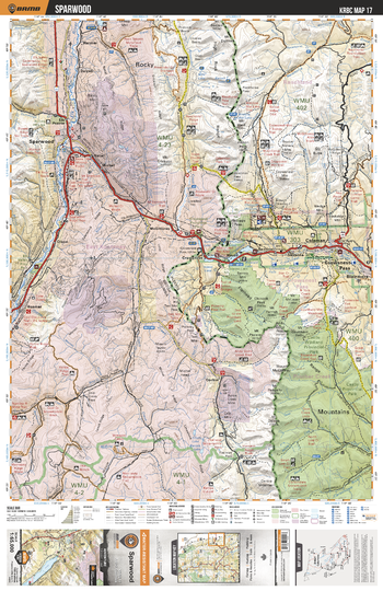
KRBC17 Sparwood - Kootenay Rockies BC Topo
Backroad Mapbooks
This recreation topographic map for the Sparwood area highlights all the logging and resource roads, multi-use trails for hikers, mountain bikers, horseback riders, cross-country skiers and snowshoers, motorized trails for ATVers and snowmobiles, fishing lakes and rivers, recreation areas, campgrounds, day-use areas, viewpoints, backcountry campsites, backcountry huts and cabins and more. No other map for the area provides you with this level of recreational or topographic detail. Special features include private land, labelled fish species and countless roads, trails and recreational Points of Interest. Covering 1,950 km2 (753 mi2), this 1:65,000 scale map measures 38 x 51 km (23.5 x 32 mi). This map includes Crowsnest Pass, Sparwood, Corbin, Harmer, Coleman, Crowsnest Lake, Crowsnest Prov Park, Blairmore, Hazell, Elk Valley Prov Park and more!
Page Size: 24 x 37 in (610 x 940 mm)
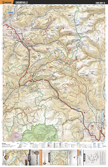
KRBC18 Cherryville - Kootenay Rockies BC Topo
Backroad Mapbooks
This recreation topographic map for the Cherryville area highlights all the logging and resource roads, multi-use trails for hikers, mountain bikers, horseback riders, cross-country skiers and snowshoers, motorized trails for ATVers and snowmobiles, fishing lakes and rivers, recreation areas, campgrounds, day-use areas, viewpoints, backcountry campsites, backcountry huts and cabins and more. No other map for the area provides you with this level of recreational or topographic detail. Special features include private land, labelled fish species and countless roads, trails and recreational Points of Interest. Covering 1,950 km2 (753 mi2), this 1:65,000 scale map measures 38 x 51 km (23.5 x 32 mi). This map includes Granby Prov Park, Cherryville, Hilton, Twin Lakes, Whatshan Lake, Snowshoe Lake, Kettle River, Monashee Lake, Pinnacle Lake, Bisson Lake, Shuswap River and more!
Page Size: 24 x 37 in (610 x 940 mm)
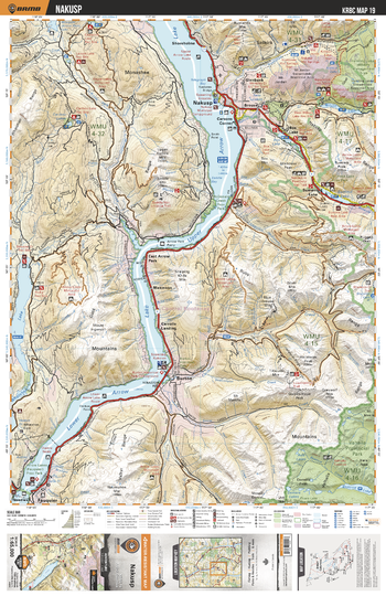
KRBC19 Nakusp - Kootenay Rockies BC Topo
Backroad Mapbooks
This recreation topographic map for the Nakusp area highlights all the logging and resource roads, multi-use trails for hikers, mountain bikers, horseback riders, cross-country skiers and snowshoers, motorized trails for ATVers and snowmobiles, fishing lakes and rivers, recreation areas, campgrounds, day-use areas, viewpoints, backcountry campsites, backcountry huts and cabins and more. No other map for the area provides you with this level of recreational or topographic detail. Special features include private land, labelled fish species and countless roads, trails and recreational Points of Interest. Covering 1,950 km2 (753 mi2), this 1:65,000 scale map measures 38 x 51 km (23.5 x 32 mi). This map includes Lower Arrow Lake, Upper Arrow Lake, Summit Lake, Wilson Lake, Box Lake, Whatshan Lake, Valhalla Prov Park, Nakusp, Shoreholme, Burton and more!
Page Size: 24 x 37 in (610 x 940 mm)
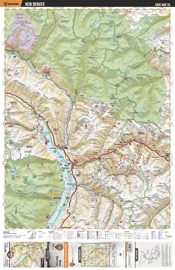
KRBC20 New Denver - Kootenay Rockies BC Topo
Backroad Mapbooks
This recreation topographic map for the New Denver area highlights all the logging and resource roads, multi-use trails for hikers, mountain bikers, horseback riders, cross-country skiers and snowshoers, motorized trails for ATVers and snowmobiles, fishing lakes and rivers, recreation areas, campgrounds, day-use areas, viewpoints, backcountry campsites, backcountry huts and cabins and more. No other map for the area provides you with this level of recreational or topographic detail. Special features include private land, labelled fish species and countless roads, trails and recreational Points of Interest. Covering 1,950 km2 (753 mi2), this 1:65,000 scale map measures 38 x 51 km (23.5 x 32 mi). This map includes Slocan Lake, Goat Range Prov Park, Valhalla Prov Park, New Denver, Hills, Blaylock, Three Forks, Meadow Mtn, Silverton, Kaslo River and more!
Page Size: 24 x 37 in (610 x 940 mm)
No search results