


XYZ Maps
XYZ London CityMap
A street map of inner London in the pastel coloured XYZ CityMap style. This map features roads, railways, London Underground, places of interest, parks, major buildings and other features.
XYZ Postcode Areas
Postcode Areas are the first two letters of the Postcode (e.g. EH) and there are 120 in Great Britain, plus one each for Northern Ireland, the Isle of Man, Guernsey and Jersey. In most areas our boundaries are finely detailed and created from following real features on air photography. The Postcode Areas are shown in red on top of appropriate map backgrounds depending on the zoom level. Use the Postcode Areas to get an overview of the postcode system, to allocate sales territories, etc.
XYZ Postcode Districts
Postcode Districts are the first two letters plus two digits of the Postcode before the space (e.g. EH22) and there are nearly 3 000. In most areas our boundaries are finely detailed and created from following real features on air photography. The Postcode Areas and Postcode Districts are shown in red on top of appropriate map backgrounds depending on the zoom level. Use Postcode Districts for regional sales territories, delivery zones, marketing, etc.
XYZ Postcode Sectors
Postcode Sectors are given by the number after the space in the Postcode (e.g. EH22 2) and there are over 10 000. In most areas our boundaries are finely detailed and created from following real features on air photography. The Postcode Areas, Postcode Districts and Sectors are shown in red on top of appropriate map backgrounds depending on the zoom level. Use Postcode Sectors for the most detailed Postcode mapping, e.g. city or regional sales territories, delivery zones, marketing, etc.
XYZ UK Historical 1940s England, Wales
Ordnance Survey 1 inch to the mile (1:63 360) colour mapping of England and Wales from the New Popular Edition of the late 1940s. This forerunner to the modern LandRanger maps lets you see what your area was like 70 years ago. Converted to the present day GB National Grid.
XYZ UK Historical Bartholomew Scotland 1920
Bartholomew mapping at 1:126 000 in the same style as the revolutionary Survey Atlas of Scotland (1912), the first recognisably ‘modern’ atlas mapping. These maps date from the 1920s and give hours of interest given the changes that have occurred since. Converted to the present day GB National Grid.
XYZ UK Historical Scotland 1920
Ordnance Survey 1 inch to the mile (1:63 360) colour mapping of Scotland from the Popular Edition of the late 1920s / early 1930s. This forerunner to the modern LandRanger maps lets you see what your area was like 70 years ago. Converted to the present day GB National Grid.
XYZ UK Strategic Health Authorities and Health Boards
Strategic Health Authorities for England, and Health Boards for Wales, Scotland and Northern Ireland.
XYZ World Physical
Very high resolution detailed World mapping with a combination of physical colours showing the Earth before human influence and hill-shading. All the usual map features such as cities, roads, rivers, lakes, railways, airports and so forth. Updated in 2013. The Miller Cylindrical projection gives a good compromise between shape, scale and area.
XYZ World Political
Very high resolution detailed World mapping with a combination of bright political colours and hill-shading. All the usual map features such as cities, roads, rivers, lakes, railways, airports and so forth. Updated in 2013, and winner of multiple awards. The Miller Cylindrical projection gives a good compromise between shape, scale and area.
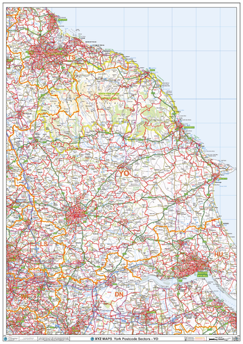
York - YO - Postcode Wall Map
The York Postcode Sector Wall Map shows detailed postcode sector boundaries (YO1 1, YO1 2) on a comprehensive background and is perfect for determining postcode boundaries for sales areas, planning mailshots and also an excellent reference for logistics. This wall map covers the whole of the YO Postcode Area.
Page Size: 33.25 x 47 in (841 x 1189 mm)
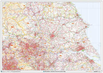
Yorkshire Postcode Sector Wall Map (S13)
The Yorkshire Postcode Sector Wall Map shows detailed postcode sector boundaries along with its associated label (YO1 1, YO1 2) on a comprehensive background and is perfect for determining postcode boundaries, for sales, logistics, planning mailshots or as a regional reference guide.
Page Size: 47 x 33.25 in (1189 x 841 mm)