


The Times
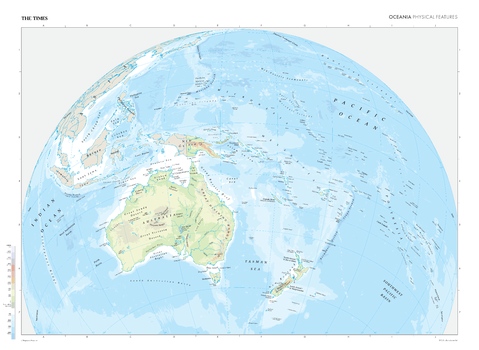
The Times Map of Oceania (Physical Features)
This map of Oceania is a benchmark of cartographic excellence, taken from the industry leading Times Comprehensive Atlas of the World series. Showing the full extent of physical features within Oceania, this map covers Australia, New Zealand, New Guinea and the surrounding islands and island groups. Placed in situ and with physical features, such as lakes, rivers and mountain ranges clearly identified, this is a coherent and informative visual guide to Oceania.
Page Size: 36.5 x 26.75 in (924 x 675 mm)

The Times Map of Oceania (Physical Features) - Compact
This map of Oceania is a benchmark of cartographic excellence, taken from the industry leading Times Comprehensive Atlas of the World series. Showing the full extent of physical features within Oceania, this map covers Australia, New Zealand, New Guinea and the surrounding islands and island groups. Placed in situ and with physical features, such as lakes, rivers and mountain ranges clearly identified, this is a coherent and informative visual guide to Oceania.
Page Size: 22.25 x 16.25 in (561 x 410 mm)
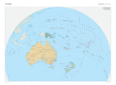
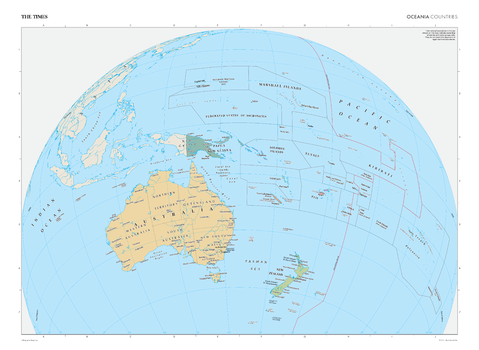
The Times Map of Oceania (Political Features)
This map of Oceania's political features is a benchmark of cartographic excellence, taken from the industry leading Times Comprehensive Atlas of the World series. Showing the full extent of Oceania with clearly marked international boundaries detailing Island and Island Group ownership. Australia, New Zealand, and New Guinea are all clearly identifiable, as are the numerous island groups within this area, including: Solomon Islands, Federated States of Micronesia and Fiji. Each element is carefully chosen to make the map a coherent and attractive visual guide to Oceania's political features.
Page Size: 36.5 x 26.75 in (924 x 675 mm)
The Times Map of Oceania (Political Features) - Compact
This map of Oceania's political features is a benchmark of cartographic excellence, taken from the industry leading Times Comprehensive Atlas of the World series. Showing the full extent of Oceania with clearly marked international boundaries detailing Island and Island Group ownership. Australia, New Zealand, and New Guinea are all clearly identifiable, as are the numerous island groups within this area, including: Solomon Islands, Federated States of Micronesia and Fiji. Each element is carefully chosen to make the map a coherent and attractive visual guide to Oceania's political features.
Page Size: 22.25 x 16.25 in (561 x 410 mm)
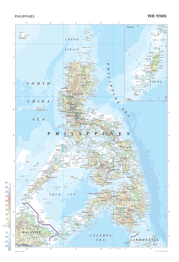
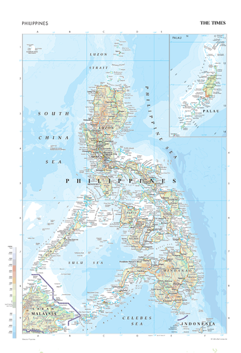
The Times Map of Philippines
This map of the Philippines is a benchmark of cartographic excellence, taken from the industry leading Times Comprehensive Atlas of the World. Published in full colour, this map of the Philippines is beautifully re-designed and fully updated. Islands including Luzon, Mindanao, Seram, and Samar are clearly identifiable, as are all major cities: Quezon City, Davao City, Antipolo and the Capital, Manilla. Accompanying the detailed map of the Philippines’ many islands is an inset map of the independent archipelago of Palau. Each element is carefully chosen to make the map a coherent and attractive visual guide to the Philippines.
Page Size: 18.25 x 26.75 in (462 x 675 mm)
The Times Map of Philippines - Compact
This map of the Philippines is a benchmark of cartographic excellence, taken from the industry leading Times Comprehensive Atlas of the World. Published in full colour, this map of the Philippines is beautifully re-designed and fully updated. Islands including Luzon, Mindanao, Seram, and Samar are clearly identifiable, as are all major cities: Quezon City, Davao City, Antipolo and the Capital, Manilla. Accompanying the detailed map of the Philippines’ many islands is an inset map of the independent archipelago of Palau. Each element is carefully chosen to make the map a coherent and attractive visual guide to the Philippines.
Page Size: 11.25 x 16.25 in (281 x 410 mm)
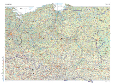
The Times Map of Poland
This map of Poland is a benchmark of cartographic excellence, taken from the industry leading Times Comprehensive Atlas of the World. There is a high level of detail packed into the map, yet the positioning of every element is carefully chosen to make the map coherent and attractive. Major cities including Krakow, Wroclaw and Lodz are clearly identifiable, as is the capital, Warszawa (Warsaw). International borders are easily seen, as are regional boundaries within Poland. Supplementary mapping covers eastern Ukraine, Belarus and Lithuania, west Germany and the north of the Czech Republic.
Page Size: 36.5 x 26.75 in (924 x 675 mm)
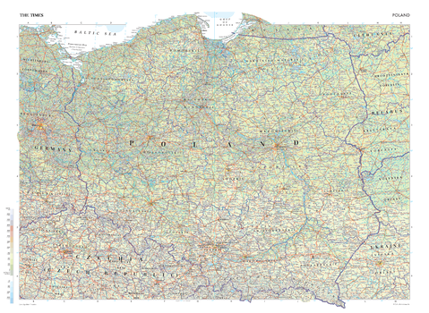
The Times Map of Poland - Compact
This map of Poland is a benchmark of cartographic excellence, taken from the industry leading Times Comprehensive Atlas of the World. There is a high level of detail packed into the map, yet the positioning of every element is carefully chosen to make the map coherent and attractive. Major cities including Krakow, Wroclaw and Lodz are clearly identifiable, as is the capital, Warszawa (Warsaw). International borders are easily seen, as are regional boundaries within Poland. Supplementary mapping covers eastern Ukraine, Belarus and Lithuania, west Germany and the north of the Czech Republic.
Page Size: 22.25 x 16.25 in (561 x 410 mm)
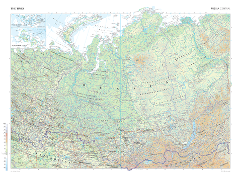
The Times Map of Russia (Central)
This map of Russia's central region stands as a benchmark of cartographic excellence, sourced from the industry-leading Times Comprehensive Atlas of the World. Published in full colour, this map offers a comprehensive and updated view of the vast landscapes that appear in this region. Additional inset maps of Franz Josef Land and Severnaya Zemlya also provide further detail. With meticulous attention to detail, this map is an indispensable guide to the geographic intricacies of Russia's Central region.
Page Size: 36.5 x 26.75 in (924 x 675 mm)

The Times Map of Russia (Central) - Compact
This map of Russia's central region stands as a benchmark of cartographic excellence, sourced from the industry-leading Times Comprehensive Atlas of the World. Published in full colour, this map offers a comprehensive and updated view of the vast landscapes that appear in this region. Additional inset maps of Franz Josef Land and Severnaya Zemlya also provide further detail. With meticulous attention to detail, this map is an indispensable guide to the geographic intricacies of Russia's Central region.
Page Size: 22.25 x 16.25 in (561 x 410 mm)
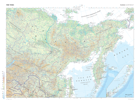
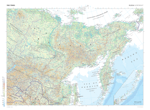
The Times Map of Russia (Northeast)
This map of Russia's north-eastern regions stands as a benchmark of cartographic excellence, sourced from the industry-leading Times Comprehensive Atlas of the World. Published in full colour, this map offers a comprehensive and updated view of the landscapes that make up this region. Prominent features such as the vast Siberian wilderness and the varied coastline along the Sea of Okhotsk are clearly identifiable, while an inset map of the Kuril Islands provides a more detailed view of this area. With meticulous attention to detail, this map is an indispensable guide to the geographic intricacies of the Russia's northeast.
Page Size: 36.5 x 26.75 in (924 x 675 mm)
The Times Map of Russia (Northeast) - Compact
This map of Russia's north-eastern regions stands as a benchmark of cartographic excellence, sourced from the industry-leading Times Comprehensive Atlas of the World. Published in full colour, this map offers a comprehensive and updated view of the landscapes that make up this region. Prominent features such as the vast Siberian wilderness and the varied coastline along the Sea of Okhotsk are clearly identifiable, while an inset map of the Kuril Islands provides a more detailed view of this area. With meticulous attention to detail, this map is an indispensable guide to the geographic intricacies of the Russia's northeast.
Page Size: 22.25 x 16.25 in (561 x 410 mm)

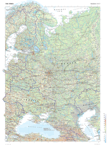
The Times Map of Russia (West)
This map of Russia's West region stands as a benchmark of cartographic excellence, sourced from the industry-leading Times Comprehensive Atlas of the World. Published in full colour, this map offers a comprehensive and updated view of the landscapes that define this expansive region. Prominent features, such as the historic capital city of Moscow, are clearly identifiable, as are geographical features such as the Black Sea and the Norwegian Fjords. With meticulous attention to detail, this map is an indispensable guide to the geographic intricacies of Russia's West.
Page Size: 26.75 x 36.5 in (675 x 924 mm)
The Times Map of Russia (West) - Compact
This map of Russia's West region stands as a benchmark of cartographic excellence, sourced from the industry-leading Times Comprehensive Atlas of the World. Published in full colour, this map offers a comprehensive and updated view of the landscapes that define this expansive region. Prominent features, such as the historic capital city of Moscow, are clearly identifiable, as are geographical features such as the Black Sea and the Norwegian Fjords. With meticulous attention to detail, this map is an indispensable guide to the geographic intricacies of Russia's West.
Page Size: 26.75 x 36.5 in (675 x 924 mm)
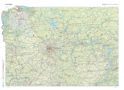
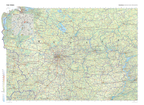
The Times Map of Russia: Moscow
This map of Russia's Moscow Region stands as a benchmark of cartographic excellence, sourced from the industry-leading Times Comprehensive Atlas of the World. Published in full colour, this map offers a comprehensive and updated view of the landscapes that define this region. Notably, this map includes an inset map of Moscow which adds further information about Russia's capital. With meticulous attention to detail, this map is an indispensable guide to the geographic intricacies of Russia's Moscow Region.
Page Size: 36.5 x 26.75 in (924 x 675 mm)
The Times Map of Russia: Moscow - Compact
This map of Russia's Moscow Region stands as a benchmark of cartographic excellence, sourced from the industry-leading Times Comprehensive Atlas of the World. Published in full colour, this map offers a comprehensive and updated view of the landscapes that define this region. Notably, this map includes an inset map of Moscow which adds further information about Russia's capital. With meticulous attention to detail, this map is an indispensable guide to the geographic intricacies of Russia's Moscow Region.
Page Size: 22.25 x 16.25 in (561 x 410 mm)
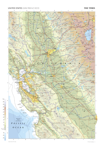
The Times Map of San Francisco (United States)
This map of San Francisco stands as a benchmark of cartographic excellence, sourced from the industry-leading Times Comprehensive Atlas of the World. Published in full colour, this map offers a comprehensive and updated view of the diverse landscapes and attractions that characterise this iconic city and its surrounding area. Prominent geographical features such as the Central Valley and the Sierra Nevada mountain range can easily be identified, as can cities such as Sacramento and San Jose. With meticulous attention to detail, this map is an indispensable guide to the geographic intricacies and highlights of San Francisco.
Page Size: 18.25 x 26.75 in (462 x 675 mm)
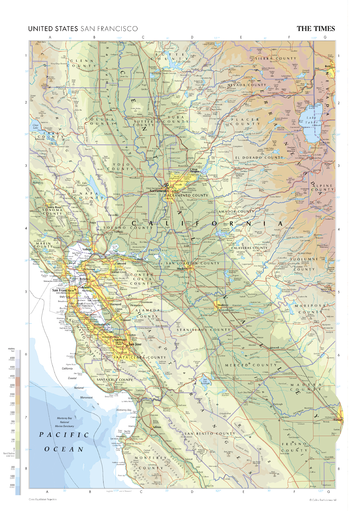
The Times Map of San Francisco (United States) - Compact
This map of San Francisco stands as a benchmark of cartographic excellence, sourced from the industry-leading Times Comprehensive Atlas of the World. Published in full colour, this map offers a comprehensive and updated view of the diverse landscapes and attractions that characterise this iconic city and its surrounding area. Prominent geographical features such as the Central Valley and the Sierra Nevada mountain range can easily be identified, as can cities such as Sacramento and San Jose. With meticulous attention to detail, this map is an indispensable guide to the geographic intricacies and highlights of San Francisco.
Page Size: 11.25 x 16.25 in (281 x 410 mm)
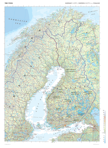
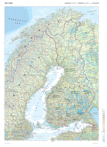
The Times Map of Scandinavia (North)
This map of North Scandinavia stands as a benchmark of cartographic excellence, sourced from the industry-leading Times Comprehensive Atlas of the World. Published in full colour, this map offers a comprehensive and updated view of the landscapes that are found in this northern region. Prominent features such as the stunning fjords of Norway, the Gulf of Bothnia, and key cities such as Helsinki and Stockholm are clearly identifiable. With meticulous attention to detail, this map is an indispensable guide to the geographic intricacies of North Scandinavia.
Page Size: 26.75 x 36.5 in (675 x 924 mm)
The Times Map of Scandinavia (North) - Compact
This map of North Scandinavia stands as a benchmark of cartographic excellence, sourced from the industry-leading Times Comprehensive Atlas of the World. Published in full colour, this map offers a comprehensive and updated view of the landscapes that are found in this northern region. Prominent features such as the stunning fjords of Norway, the Gulf of Bothnia, and key cities such as Helsinki and Stockholm are clearly identifiable. With meticulous attention to detail, this map is an indispensable guide to the geographic intricacies of North Scandinavia.
Page Size: 16.25 x 22.25 in (410 x 561 mm)