The Times
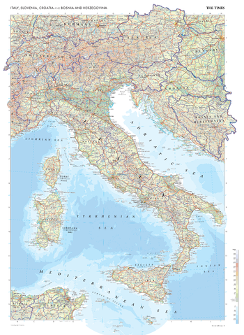
The Times Map of Italy, Slovenia, Croatia and Bosnia and Herzegovina
This map of Italy, Slovenia, Croatia and Bosnia and Herzegovina is a benchmark of cartographic excellence, taken from the industry leading Times Comprehensive Atlas of the World. Major cities including Napoli, Milano, and Split are easily identifiable, as are the capitals of Roma (Rome), Ljubljana, Zagreb, and Sarajevo. International borders are clearly marked as are regional boundaries within all countries, and geographical features, such as the Alps. Supplementary mapping covers Switzerland, Austria and Slovenia in full, as well as western Hungary, and southern Germany. The islands of Corse (Corsica), Sardegna (Sardinia), and Sicilia (Sicily) are also fully mapped.
Page Size: 26.75 x 36.5 in (675 x 924 mm)
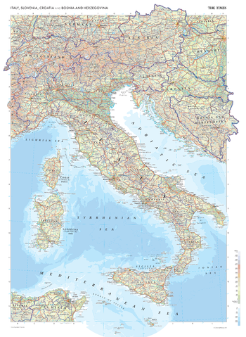
The Times Map of Italy, Slovenia, Croatia and Bosnia and Herzegovina - Compact
This map of Italy, Slovenia, Croatia and Bosnia and Herzegovina is a benchmark of cartographic excellence, taken from the industry leading Times Comprehensive Atlas of the World. Major cities including Napoli, Milano, and Split are easily identifiable, as are the capitals of Roma (Rome), Ljubljana, Zagreb, and Sarajevo. International borders are clearly marked as are regional boundaries within all countries, and geographical features, such as the Alps. Supplementary mapping covers Switzerland, Austria and Slovenia in full, as well as western Hungary, and southern Germany. The islands of Corse (Corsica), Sardegna (Sardinia), and Sicilia (Sicily) are also fully mapped.
Page Size: 16.25 x 22.25 in (410 x 561 mm)
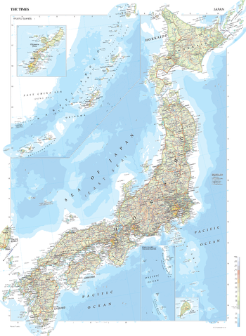
The Times Map of Japan
This map of Japan is a benchmark of cartographic excellence, taken from the industry leading Times Comprehensive Atlas of the World. Alongside the main islands of Hokkaido, Honshu, Shikoku, Kyushu, and Okinawa, the many other islands that make up Japan are easily identifiable. Additional inset maps of the Ryukya Islands and the Bonin Islands and Volcano Islands are expanded upon by further insets showing the islands of Okinawa and Iō Tō. Major cities of Osaka and Nagoya are easily identifiable, as is the capital, Tokyo. Each element is carefully chosen to make the map a coherent and attractive visual guide to Japan.
Page Size: 26.75 x 36.5 in (675 x 924 mm)
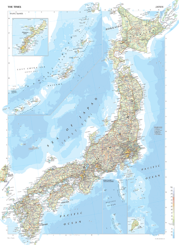
The Times Map of Japan - Compact
This map of Japan is a benchmark of cartographic excellence, taken from the industry leading Times Comprehensive Atlas of the World. Alongside the main islands of Hokkaido, Honshu, Shikoku, Kyushu, and Okinawa, the many other islands that make up Japan are easily identifiable. Additional inset maps of the Ryukya Islands and the Bonin Islands and Volcano Islands are expanded upon by further insets showing the islands of Okinawa and Iō Tō. Major cities of Osaka and Nagoya are easily identifiable, as is the capital, Tokyo. Each element is carefully chosen to make the map a coherent and attractive visual guide to Japan.
Page Size: 16.25 x 22.25 in (410 x 561 mm)
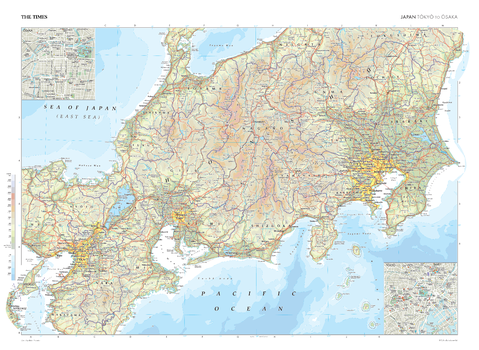
The Times Map of Japan: Tokyo to Osaka
This map of Japan, spanning from Tokyo to Osaka, stands as a benchmark of cartographic excellence, taken from the industry leading Times Comprehensive Atlas of the World. Presented in full colour, this map captures the intricate details of the region, showcasing the varied landscape located between Tokyo and Osaka. Prominent cities such as Kyoto and Nagoya are clearly distinguishable, while additional detail is provided by inset city plan maps of Tokyo and Osaka themselves. Each cartographic element has been thoughtfully selected, creating a coherent and attractive guide to Japan's urban heartland from Tokyo to Osaka.
Page Size: 36.5 x 26.75 in (924 x 675 mm)
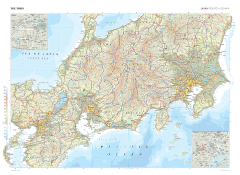
The Times Map of Japan: Tokyo to Osaka - Compact
This map of Japan, spanning from Tokyo to Osaka, stands as a benchmark of cartographic excellence, taken from the industry leading Times Comprehensive Atlas of the World. Presented in full colour, this map captures the intricate details of the region, showcasing the varied landscape located between Tokyo and Osaka. Prominent cities such as Kyoto and Nagoya are clearly distinguishable, while additional detail is provided by inset city plan maps of Tokyo and Osaka themselves. Each cartographic element has been thoughtfully selected, creating a coherent and attractive guide to Japan's urban heartland from Tokyo to Osaka.
Page Size: 22.25 x 16.25 in (561 x 410 mm)

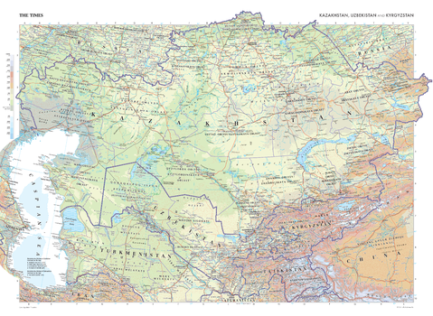
The Times Map of Kazakhstan, Uzbekistan and Kyrgyzstan
This map of Kazakhstan, Uzbekistan, and Kyrgyzstan stands as a benchmark of cartographic excellence, sourced from the industry-leading Times Comprehensive Atlas of the World. Published in full colour, this map offers a comprehensive and updated view of the landscapes that are found in this region. Prominent features such as the mountain ranges of Tien Shan and Kunlun Shan, and the Caspian Sea are clearly identifiable. With meticulous attention to detail, this map is an indispensable guide to the geographic intricacies of Kazakhstan, Uzbekistan, and Kyrgyzstan.
Page Size: 36.5 x 26.75 in (924 x 675 mm)
The Times Map of Kazakhstan, Uzbekistan and Kyrgyzstan - Compact
This map of Kazakhstan, Uzbekistan, and Kyrgyzstan stands as a benchmark of cartographic excellence, sourced from the industry-leading Times Comprehensive Atlas of the World. Published in full colour, this map offers a comprehensive and updated view of the landscapes that are found in this region. Prominent features such as the mountain ranges of Tien Shan and Kunlun Shan, and the Caspian Sea are clearly identifiable. With meticulous attention to detail, this map is an indispensable guide to the geographic intricacies of Kazakhstan, Uzbekistan, and Kyrgyzstan.
Page Size: 22.25 x 16.25 in (561 x 410 mm)
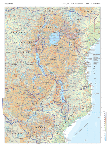
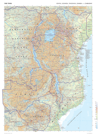
The Times Map of Kenya, Uganda, Tanzania, Zambia and Zimbabwe
This map of Kenya, Uganda, Tanzania, Zambia, and Zimbabwe stands as a benchmark of cartographic excellence, sourced from the industry-leading Times Comprehensive Atlas of the World. Published in full colour, this map offers a comprehensive and updated view of the landscapes that are found in this region. Prominent features such as the iconic Mount Kilimanjaro, Lake Victoria and the vibrant cities of Nairobi, Kampala are clearly identifiable. With meticulous attention to detail, this map is an indispensable guide to the geographic intricacies of Kenya, Uganda, Tanzania, Zambia, and Zimbabwe.
Page Size: 26.75 x 36.5 in (675 x 924 mm)
The Times Map of Kenya, Uganda, Tanzania, Zambia and Zimbabwe - Compact
This map of Kenya, Uganda, Tanzania, Zambia, and Zimbabwe stands as a benchmark of cartographic excellence, sourced from the industry-leading Times Comprehensive Atlas of the World. Published in full colour, this map offers a comprehensive and updated view of the landscapes that are found in this region. Prominent features such as the iconic Mount Kilimanjaro, Lake Victoria and the vibrant cities of Nairobi, Kampala are clearly identifiable. With meticulous attention to detail, this map is an indispensable guide to the geographic intricacies of Kenya, Uganda, Tanzania, Zambia, and Zimbabwe.
Page Size: 16.25 x 22.25 in (410 x 561 mm)
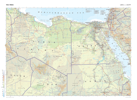
The Times Map of Libya and Egypt
This map of Libya and Egypt stands as a benchmark of cartographic excellence, sourced from the industry-leading Times Comprehensive Atlas of the World. Published in full colour, this map offers a comprehensive and updated view of the landscapes that are found in this region. Prominent features such as the historic cities of Cairo, Tripoli, and the vast deserts are clearly identifiable. Additional mapping covers Niger, Chad, Sudan, Israel, Jordan, Saudi Arabia and Tunisia. With meticulous attention to detail, this map is an indispensable guide to the geographic intricacies of Libya and Egypt.
Page Size: 36.5 x 26.75 in (924 x 675 mm)

The Times Map of Libya and Egypt - Compact
This map of Libya and Egypt stands as a benchmark of cartographic excellence, sourced from the industry-leading Times Comprehensive Atlas of the World. Published in full colour, this map offers a comprehensive and updated view of the landscapes that are found in this region. Prominent features such as the historic cities of Cairo, Tripoli, and the vast deserts are clearly identifiable. Additional mapping covers Niger, Chad, Sudan, Israel, Jordan, Saudi Arabia and Tunisia. With meticulous attention to detail, this map is an indispensable guide to the geographic intricacies of Libya and Egypt.
Page Size: 22.25 x 16.25 in (561 x 410 mm)
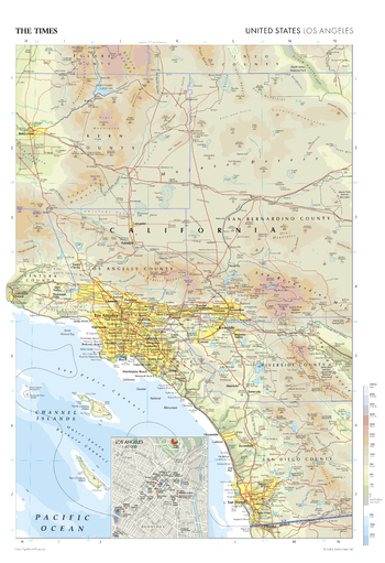
The Times Map of Los Angeles (United States)
This map of Los Angeles stands as a benchmark of cartographic excellence, sourced from the industry-leading Times Comprehensive Atlas of the World. Published in full colour, this map offers a comprehensive and updated view of the landscapes that are found in this iconic region. Notably, the map includes a city plan inset of Los Angeles, adding an extra layer of detail to this sprawling metropolis. With meticulous attention to detail, this map is an indispensable guide to the geographic intricacies and highlights of Los Angeles.
Page Size: 18.25 x 26.75 in (462 x 675 mm)

The Times Map of Los Angeles (United States) - Compact
This map of Los Angeles stands as a benchmark of cartographic excellence, sourced from the industry-leading Times Comprehensive Atlas of the World. Published in full colour, this map offers a comprehensive and updated view of the landscapes that are found in this iconic region. Notably, the map includes a city plan inset of Los Angeles, adding an extra layer of detail to this sprawling metropolis. With meticulous attention to detail, this map is an indispensable guide to the geographic intricacies and highlights of Los Angeles.
Page Size: 11.25 x 16.25 in (281 x 410 mm)

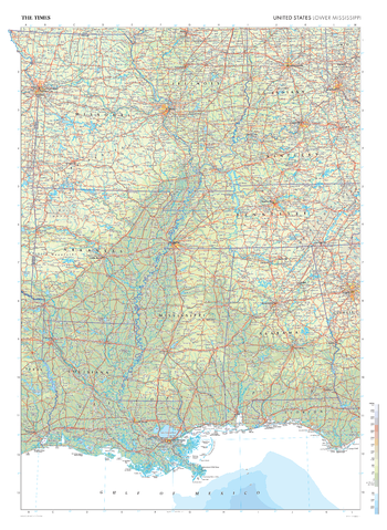
The Times Map of Lower Mississippi (United States)
This map of the US Lower Mississippi region stands as a benchmark of cartographic excellence, sourced from the industry-leading Times Comprehensive Atlas of the World. Published in full colour, this map offers a comprehensive and updated view of the diverse landscapes and cultures that define this area. Encompassing states such as Louisiana, Mississippi, Arkansas, Tennessee, Alabama and more, this map includes prominent features such as the iconic Mississippi River, and the cities of New Orleans, Memphis, and St Louis. With meticulous attention to detail, this map is an indispensable guide to the geographic intricacies of the US Lower Mississippi region.
Page Size: 26.75 x 36.5 in (675 x 924 mm)
The Times Map of Lower Mississippi (United States) - Compact
This map of the US Lower Mississippi region stands as a benchmark of cartographic excellence, sourced from the industry-leading Times Comprehensive Atlas of the World. Published in full colour, this map offers a comprehensive and updated view of the diverse landscapes and cultures that define this area. Encompassing states such as Louisiana, Mississippi, Arkansas, Tennessee, Alabama and more, this map includes prominent features such as the iconic Mississippi River, and the cities of New Orleans, Memphis, and St Louis. With meticulous attention to detail, this map is an indispensable guide to the geographic intricacies of the US Lower Mississippi region.
Page Size: 16.25 x 22.25 in (410 x 561 mm)

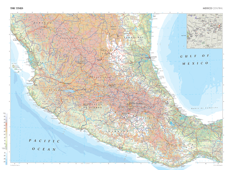
The Times Map of Mexico (Central)
This map of Central Mexico stands as a benchmark of cartographic excellence, sourced from the industry-leading Times Comprehensive Atlas of the World. Published in full colour, this map offers a comprehensive and updated view of the diverse landscapes and attractions that define this region. Geographical features include the Sierra Madre del Sur and the Sierra Madre Occidental Mountain ranges, and the Gulf of Mexico. Notably, the map includes a city inset of Mexico City, adding an extra layer of detail to this sprawling capital. With meticulous attention to detail, this map is an indispensable guide to the geographic intricacies of Central Mexico.
Page Size: 36.5 x 26.75 in (924 x 675 mm)
The Times Map of Mexico (Central) - Compact
This map of Central Mexico stands as a benchmark of cartographic excellence, sourced from the industry-leading Times Comprehensive Atlas of the World. Published in full colour, this map offers a comprehensive and updated view of the diverse landscapes and attractions that define this region. Geographical features include the Sierra Madre del Sur and the Sierra Madre Occidental Mountain ranges, and the Gulf of Mexico. Notably, the map includes a city inset of Mexico City, adding an extra layer of detail to this sprawling capital. With meticulous attention to detail, this map is an indispensable guide to the geographic intricacies of Central Mexico.
Page Size: 22.25 x 16.25 in (561 x 410 mm)
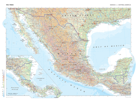
The Times Map of Mexico and Central America
This map of the Mexico and Central America is a benchmark of cartographic excellence, taken from the industry leading Times Comprehensive Atlas of the World. In addition to Mexico, this map provides full coverage of Guatemala, El Salvador, Belize, Honduras, Nicaragua, Panama, and Costa Rica. The capitals cities of Ciudad de Mexico (Mexico City) Guatemala City, Panama City, San Jose, San Salvador, Tegucigalpa, Managua, and Belmopan are easily identifiable. International borders and regional boundaries are clearly marked, as are geographical features, including the Sierra Madre del Sur and the Sierra Madre Occidental Mountain ranges in Mexico. Each element is carefully chosen to make the map a coherent and attractive visual guide to Mexico and Central America.
Page Size: 36.5 x 26.75 in (924 x 675 mm)
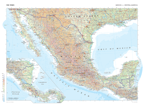
The Times Map of Mexico and Central America - Compact
This map of the Mexico and Central America is a benchmark of cartographic excellence, taken from the industry leading Times Comprehensive Atlas of the World. In addition to Mexico, this map provides full coverage of Guatemala, El Salvador, Belize, Honduras, Nicaragua, Panama, and Costa Rica. The capitals cities of Ciudad de Mexico (Mexico City) Guatemala City, Panama City, San Jose, San Salvador, Tegucigalpa, Managua, and Belmopan are easily identifiable. International borders and regional boundaries are clearly marked, as are geographical features, including the Sierra Madre del Sur and the Sierra Madre Occidental Mountain ranges in Mexico. Each element is carefully chosen to make the map a coherent and attractive visual guide to Mexico and Central America.
Page Size: 22.25 x 16.25 in (561 x 410 mm)