The Times
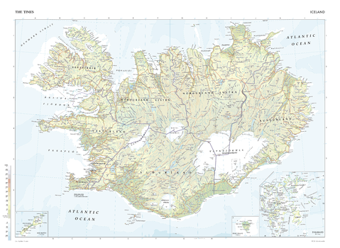
The Times Map of Iceland
This map of Iceland is a benchmark of cartographic excellence, taken from the industry leading Times Comprehensive Atlas of the World. There is a high level of detail packed into the map, yet the positioning of every element is carefully chosen to make the map coherent and attractive. The eight regions of Iceland are clearly divided and labelled accordingly, and major cities – such as the capital, Reykjavik – are easily identifiable. Inset map reveals additional information about: Svalbard, Bear Island and Jan Mayen. Each element is carefully chosen to make the map a coherent and attractive visual guide to Iceland.
Page Size: 36.5 x 26.75 in (924 x 675 mm)
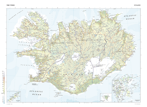
The Times Map of Iceland - Compact
This map of Iceland is a benchmark of cartographic excellence, taken from the industry leading Times Comprehensive Atlas of the World. There is a high level of detail packed into the map, yet the positioning of every element is carefully chosen to make the map coherent and attractive. The eight regions of Iceland are clearly divided and labelled accordingly, and major cities – such as the capital, Reykjavik – are easily identifiable. Inset map reveals additional information about: Svalbard, Bear Island and Jan Mayen. Each element is carefully chosen to make the map a coherent and attractive visual guide to Iceland.
Page Size: 22.25 x 16.25 in (561 x 410 mm)

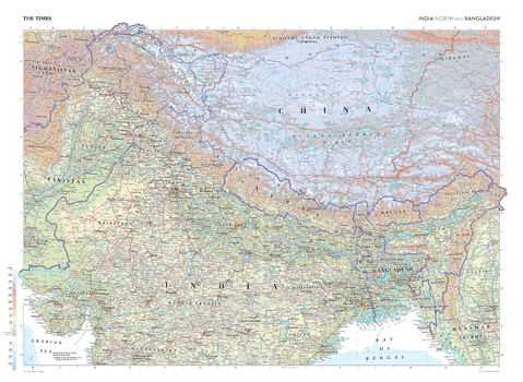
The Times Map of India (North) and Bangladesh
This map of India North and Bangladesh is a benchmark of cartographic excellence, taken from the industry leading Times Comprehensive Atlas of the World. There is a high level of detail packed into the map, yet the positioning of every element is carefully chosen to make the map coherent and attractive. This expansive map additionally covers Nepal and Bhutan in full, and major areas of Afghanistan, China, Pakistan and Myanmar. Major cities including Delhi, Dhaka and Islamabad are clearly identifiable, as are geographical features such as the Himalaya Mountain range.
Page Size: 36.5 x 26.75 in (924 x 675 mm)
The Times Map of India (North) and Bangladesh - Compact
This map of India North and Bangladesh is a benchmark of cartographic excellence, taken from the industry leading Times Comprehensive Atlas of the World. There is a high level of detail packed into the map, yet the positioning of every element is carefully chosen to make the map coherent and attractive. This expansive map additionally covers Nepal and Bhutan in full, and major areas of Afghanistan, China, Pakistan and Myanmar. Major cities including Delhi, Dhaka and Islamabad are clearly identifiable, as are geographical features such as the Himalaya Mountain range.
Page Size: 22.25 x 16.25 in (561 x 410 mm)
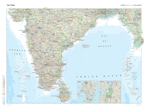
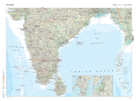
The Times Map of India (South) and Sri Lanka
This map of India's southern regions and Sri Lanka stands as a benchmark of cartographic excellence, sourced from the industry-leading Times Comprehensive Atlas of the World. Published in full colour, this map offers a comprehensive and updated view of the landscapes that are found in this region. Prominent geographical features and key cities, such as Mumbai, Kolkata, and Bengaluru, are clearly identifiable. Notably, the map includes inset city plans of Mumbai and Kolkata, and additional mapping covering southern Bangladesh and eastern Myanmar. With meticulous attention to detail, this map is an indispensable guide to the geographic and geographical intricacies of India's southern regions and Sri Lanka.
Page Size: 36.5 x 26.75 in (924 x 675 mm)
The Times Map of India (South) and Sri Lanka - Compact
This map of India's southern regions and Sri Lanka stands as a benchmark of cartographic excellence, sourced from the industry-leading Times Comprehensive Atlas of the World. Published in full colour, this map offers a comprehensive and updated view of the landscapes that are found in this region. Prominent geographical features and key cities, such as Mumbai, Kolkata, and Bengaluru, are clearly identifiable. Notably, the map includes inset city plans of Mumbai and Kolkata, and additional mapping covering southern Bangladesh and eastern Myanmar. With meticulous attention to detail, this map is an indispensable guide to the geographic and geographical intricacies of India's southern regions and Sri Lanka.
Page Size: 22.25 x 16.25 in (561 x 410 mm)
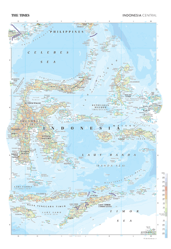
The Times Map of Indonesia (Central)
This map of Central Indonesia is a benchmark of cartographic excellence, taken from the renowned Times Comprehensive Atlas of the World. Published in full colour, this map of Central Indonesia has been thoroughly updated with meticulous attention to detail. Key islands such as Sulawesi, Flores, and Timor stand out distinctly, as do major urban centres such as Makassar. With every element thoughtfully curated, this map serves as a cohesive and visually appealing guide, providing an encompassing view of the landscapes and geography that define Central Indonesia.
Page Size: 18.25 x 26.75 in (462 x 675 mm)

The Times Map of Indonesia (Central) - Compact
This map of Central Indonesia is a benchmark of cartographic excellence, taken from the renowned Times Comprehensive Atlas of the World. Published in full colour, this map of Central Indonesia has been thoroughly updated with meticulous attention to detail. Key islands such as Sulawesi, Flores, and Timor stand out distinctly, as do major urban centres such as Makassar. With every element thoughtfully curated, this map serves as a cohesive and visually appealing guide, providing an encompassing view of the landscapes and geography that define Central Indonesia.
Page Size: 11.25 x 16.25 in (281 x 410 mm)
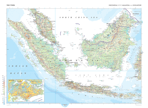
The Times Map of Indonesia (West), Malaysia and Singapore
This map of Indonesia West, Malaysia, and Singapore stands is a benchmark of cartographic excellence, sourced from the industry-leading Times Comprehensive Atlas of the World. Presented in full colour, this map offers a comprehensive and updated view of the region. Significant islands such as Sumatra, Borneo, and Jawa are easily identifiable, as are key cities including Jakarta, Kuala Lumpur; there is also a detailed inset map of Singapore. Carefully curated, this map serves as an informative and engaging guide to the geography and urban landscapes of Indonesia West, Malaysia, and Singapore.
Page Size: 36.5 x 26.75 in (924 x 675 mm)
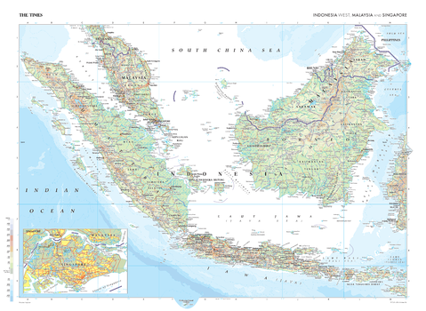
The Times Map of Indonesia (West), Malaysia and Singapore - Compact
This map of Indonesia West, Malaysia, and Singapore stands is a benchmark of cartographic excellence, sourced from the industry-leading Times Comprehensive Atlas of the World. Presented in full colour, this map offers a comprehensive and updated view of the region. Significant islands such as Sumatra, Borneo, and Jawa are easily identifiable, as are key cities including Jakarta, Kuala Lumpur; there is also a detailed inset map of Singapore. Carefully curated, this map serves as an informative and engaging guide to the geography and urban landscapes of Indonesia West, Malaysia, and Singapore.
Page Size: 22.25 x 16.25 in (561 x 410 mm)
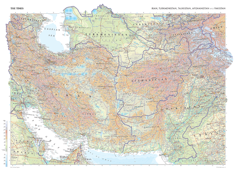
The Times Map of Iran, Turkmenistan, Tajikistan, Afghanistan and Pakistan
This map of Iran, Turkmenistan, Tajikistan, Afghanistan, and Pakistan stands as a benchmark of cartographic excellence, sourced from the industry-leading Times Comprehensive Atlas of the World. Published in full colour, this map offers a comprehensive and updated view of the landscapes that are found in this region. Prominent features such as the arid expanses of the Iranian Plateau, the rugged terrain of Afghanistan, and key cities such as Tehran, Kabul and Dubai are clearly identifiable. With meticulous attention to detail, this map is an indispensable guide to the geographic intricacies of Iran, Turkmenistan, Tajikistan, Afghanistan, and Pakistan.
Page Size: 36.5 x 26.75 in (924 x 675 mm)
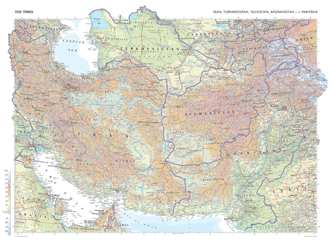
The Times Map of Iran, Turkmenistan, Tajikistan, Afghanistan and Pakistan - Compact
This map of Iran, Turkmenistan, Tajikistan, Afghanistan, and Pakistan stands as a benchmark of cartographic excellence, sourced from the industry-leading Times Comprehensive Atlas of the World. Published in full colour, this map offers a comprehensive and updated view of the landscapes that are found in this region. Prominent features such as the arid expanses of the Iranian Plateau, the rugged terrain of Afghanistan, and key cities such as Tehran, Kabul and Dubai are clearly identifiable. With meticulous attention to detail, this map is an indispensable guide to the geographic intricacies of Iran, Turkmenistan, Tajikistan, Afghanistan, and Pakistan.
Page Size: 22.25 x 16.25 in (561 x 410 mm)
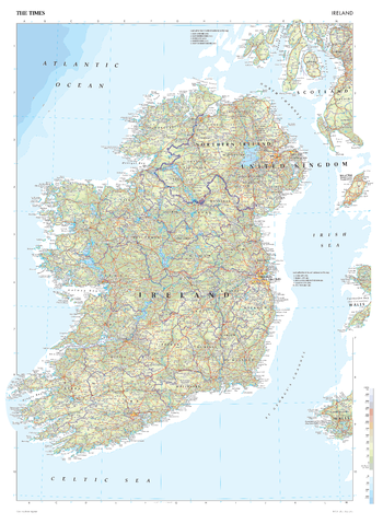
The Times Map of Ireland
This map of Ireland is a benchmark of cartographic excellence, taken from the industry leading Times Comprehensive Atlas of the World. There is a high level of detail packed into the map, yet the positioning of every element is carefully chosen to make the map coherent and attractive. Clear border between Ireland and Northern Island and further divisions to indicate county boundaries. Capital cities Dublin and Belfast are easily identifiable, as are other major cities including Cork and Londonderry. Supplementary mapping shows the Isle of Man, and the west coasts of Wales and Scotland. Each element is carefully chosen to make the map a coherent and attractive visual guide to Ireland.
Page Size: 26.75 x 36.5 in (675 x 924 mm)
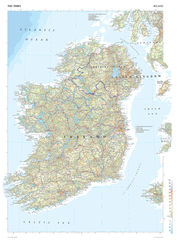
The Times Map of Ireland - Compact
This map of Ireland is a benchmark of cartographic excellence, taken from the industry leading Times Comprehensive Atlas of the World. There is a high level of detail packed into the map, yet the positioning of every element is carefully chosen to make the map coherent and attractive. Clear border between Ireland and Northern Island and further divisions to indicate county boundaries. Capital cities Dublin and Belfast are easily identifiable, as are other major cities including Cork and Londonderry. Supplementary mapping shows the Isle of Man, and the west coasts of Wales and Scotland. Each element is carefully chosen to make the map a coherent and attractive visual guide to Ireland.
Page Size: 16.25 x 22.25 in (410 x 561 mm)
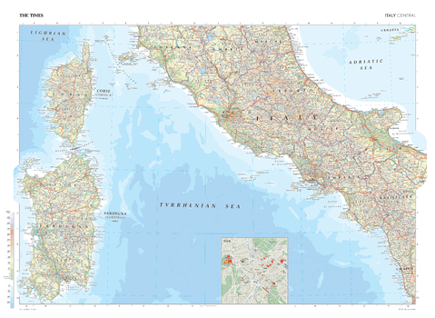
The Times Map of Italy (Central)
This map of Central Italy stands as a benchmark of cartographic excellence, sourced from the industry-leading Times Comprehensive Atlas of the World. Published in full colour, this map offers a comprehensive and updated view of the landscapes that are found in this region. Prominent features such as the historic cities of Rome and Naples, and the islands of Corsica and Sardinia are clearly identifiable. Notably, the map includes a city plan of Rome, adding an extra layer of detail to this iconic capital city. With meticulous attention to detail, this map is an indispensable guide to the geographic intricacies of Central Italy.
Page Size: 36.5 x 26.75 in (924 x 675 mm)
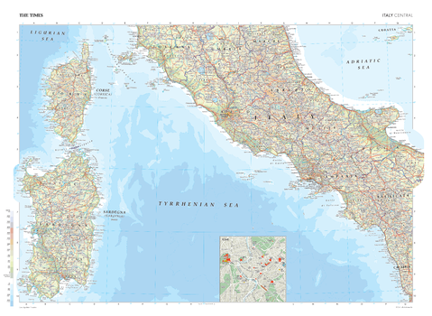
The Times Map of Italy (Central) - Compact
This map of Central Italy stands as a benchmark of cartographic excellence, sourced from the industry-leading Times Comprehensive Atlas of the World. Published in full colour, this map offers a comprehensive and updated view of the landscapes that are found in this region. Prominent features such as the historic cities of Rome and Naples, and the islands of Corsica and Sardinia are clearly identifiable. Notably, the map includes a city plan of Rome, adding an extra layer of detail to this iconic capital city. With meticulous attention to detail, this map is an indispensable guide to the geographic intricacies of Central Italy.
Page Size: 22.25 x 16.25 in (561 x 410 mm)

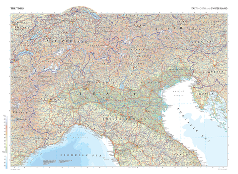
The Times Map of Italy (North) and Switzerland
This map of northern Italy and Switzerland stands as a benchmark of cartographic excellence, sourced from the industry-leading Times Comprehensive Atlas of the World. Published in full colour, this map offers a comprehensive and updated view of the diverse landscapes that are found in this region, along with additional mapping covering large parts of Austria, Slovenia and Croatia. Prominent features such as the Alps, the historic cities of Milan, Turin, and bodies of water such as the Ligurian and Adriatic Seas are clearly identifiable. With meticulous attention to detail, this map is an indispensable guide to the geographic intricacies of northern Italy and Switzerland.
Page Size: 22.25 x 16.25 in (561 x 410 mm)
The Times Map of Italy (North) and Switzerland - Compact
This map of northern Italy and Switzerland stands as a benchmark of cartographic excellence, sourced from the industry-leading Times Comprehensive Atlas of the World. Published in full colour, this map offers a comprehensive and updated view of the diverse landscapes that are found in this region, along with additional mapping covering large parts of Austria, Slovenia and Croatia. Prominent features such as the Alps, the historic cities of Milan, Turin, and bodies of water such as the Ligurian and Adriatic Seas are clearly identifiable. With meticulous attention to detail, this map is an indispensable guide to the geographic intricacies of northern Italy and Switzerland.
Page Size: 22.25 x 16.25 in (561 x 410 mm)
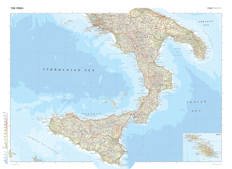
The Times Map of Italy (South)
This map of Southern Italy stands as a benchmark of cartographic excellence, sourced from the industry-leading Times Comprehensive Atlas of the World. Published in full colour, this map offers a comprehensive and updated view of the landscapes that are found in this region. Prominent features such as the city of Naples, the island of Sicily, and the picturesque coastlines are clearly identifiable. Notably, the map includes an inset of Malta, adding an extra layer of detail to this distinctive island. With meticulous attention to detail, this map is an indispensable guide to the geographic intricacies of Southern Italy.
Page Size: 36.5 x 26.75 in (924 x 675 mm)

The Times Map of Italy (South) - Compact
This map of Southern Italy stands as a benchmark of cartographic excellence, sourced from the industry-leading Times Comprehensive Atlas of the World. Published in full colour, this map offers a comprehensive and updated view of the landscapes that are found in this region. Prominent features such as the city of Naples, the island of Sicily, and the picturesque coastlines are clearly identifiable. Notably, the map includes an inset of Malta, adding an extra layer of detail to this distinctive island. With meticulous attention to detail, this map is an indispensable guide to the geographic intricacies of Southern Italy.
Page Size: 22.25 x 16.25 in (561 x 410 mm)