


The Times
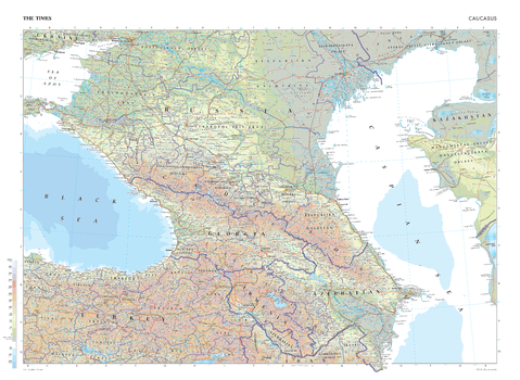
The Times Map of the Caucasus
This map of the Caucasus stands as a benchmark of cartographic excellence, sourced from the industry-leading Times Comprehensive Atlas of the World. Published in full colour, this map offers a comprehensive and updated view of the varied geographical features that appear in this region. Prominent features such as the Caucasus Mountains, the Caspian Sea and the Black Sea, and key cities such as Tbilisi, Yerevan and Baki are clearly identifiable. With meticulous attention to detail, this map is an indispensable guide to the geographic intricacies of the Caucasus.
Page Size: 36.5 x 26.75 in (924 x 675 mm)

The Times Map of the Caucasus - Compact
This map of the Caucasus stands as a benchmark of cartographic excellence, sourced from the industry-leading Times Comprehensive Atlas of the World. Published in full colour, this map offers a comprehensive and updated view of the varied geographical features that appear in this region. Prominent features such as the Caucasus Mountains, the Caspian Sea and the Black Sea, and key cities such as Tbilisi, Yerevan and Baki are clearly identifiable. With meticulous attention to detail, this map is an indispensable guide to the geographic intricacies of the Caucasus.
Page Size: 22.25 x 16.25 in (561 x 410 mm)
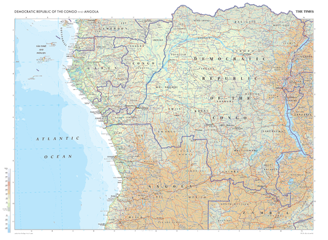
The Times Map of the Democratic Republic of the Congo and Angola
This map of the Democratic Republic of the Congo and Angola stands as a benchmark of cartographic excellence, sourced from the industry-leading Times Comprehensive Atlas of the World. Published in full colour, this map offers a comprehensive and updated view of the landscapes that are found in this region. Prominent features such as Lake Tanganyika and the historic cities of Kinshasa and Luanda are clearly identifiable as are geographical features such as the Great Rift Valley. Additional mapping covers parts of Zambia, Tanzania, Gabon, Burundi, and many more. With meticulous attention to detail, this map is an indispensable guide to the geographic intricacies of the Democratic Republic of the Congo and Angola.
Page Size: 36.5 x 26.75 in (924 x 675 mm)
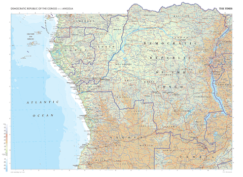
The Times Map of the Democratic Republic of the Congo and Angola - Compact
This map of the Democratic Republic of the Congo and Angola stands as a benchmark of cartographic excellence, sourced from the industry-leading Times Comprehensive Atlas of the World. Published in full colour, this map offers a comprehensive and updated view of the landscapes that are found in this region. Prominent features such as Lake Tanganyika and the historic cities of Kinshasa and Luanda are clearly identifiable as are geographical features such as the Great Rift Valley. Additional mapping covers parts of Zambia, Tanzania, Gabon, Burundi, and many more. With meticulous attention to detail, this map is an indispensable guide to the geographic intricacies of the Democratic Republic of the Congo and Angola.
Page Size: 22.25 x 16.25 in (561 x 410 mm)
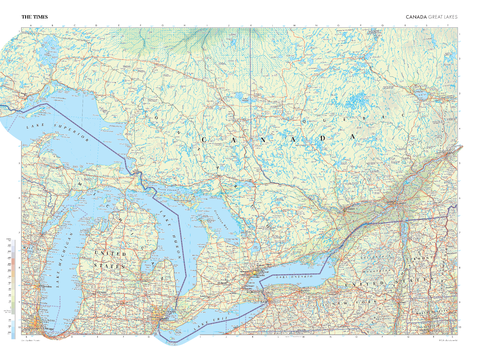
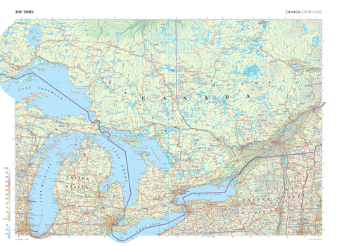
The Times Map of the Great Lakes (Canada)
This map of the Great Lakes region in Canada stands as a benchmark of cartographic excellence, sourced from the industry-leading Times Comprehensive Atlas of the World. Published in full colour, this map offers a comprehensive and updated view of the Great Lakes. Lake Superior, Lake Huron, Lake Erie, and Lake Ontario are all clearly identifiable, as are the numerous smaller lakes in this region. Cities including Toronto, Ottawa, and Montreal are also clearly visible. With meticulous attention to detail, this map is an indispensable guide to the geographic intricacies of the Great Lakes.
Page Size: 36.5 x 26.75 in (924 x 675 mm)
The Times Map of the Great Lakes (Canada) - Compact
This map of the Great Lakes region in Canada stands as a benchmark of cartographic excellence, sourced from the industry-leading Times Comprehensive Atlas of the World. Published in full colour, this map offers a comprehensive and updated view of the Great Lakes. Lake Superior, Lake Huron, Lake Erie, and Lake Ontario are all clearly identifiable, as are the numerous smaller lakes in this region. Cities including Toronto, Ottawa, and Montreal are also clearly visible. With meticulous attention to detail, this map is an indispensable guide to the geographic intricacies of the Great Lakes.
Page Size: 22.25 x 16.25 in (561 x 410 mm)
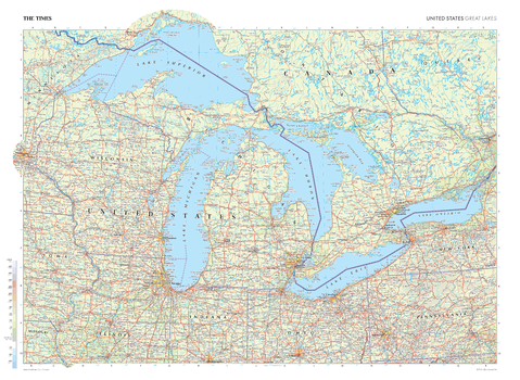
The Times Map of the Great Lakes (United States)
This map of the US Great Lakes region stands as a benchmark of cartographic excellence, sourced from the industry-leading Times Comprehensive Atlas of the World. Published in full colour, this map offers a comprehensive and updated view of the landscapes found in this area. Encompassing states such as Michigan, Wisconsin, Ohio, and more, this map includes many of the majestic Great Lakes: Michigan, Superior, Erie, Ontario, and Huron. With meticulous attention to detail, this map is an indispensable guide to the geographic intricacies of the US Great Lakes region.
Page Size: 36.5 x 26.75 in (924 x 675 mm)
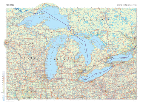
The Times Map of the Great Lakes (United States) - Compact
This map of the US Great Lakes region stands as a benchmark of cartographic excellence, sourced from the industry-leading Times Comprehensive Atlas of the World. Published in full colour, this map offers a comprehensive and updated view of the landscapes found in this area. Encompassing states such as Michigan, Wisconsin, Ohio, and more, this map includes many of the majestic Great Lakes: Michigan, Superior, Erie, Ontario, and Huron. With meticulous attention to detail, this map is an indispensable guide to the geographic intricacies of the US Great Lakes region.
Page Size: 22.25 x 16.25 in (561 x 410 mm)
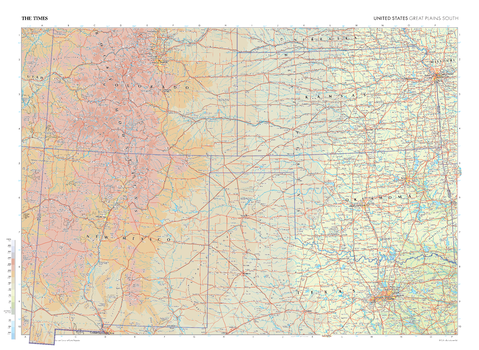
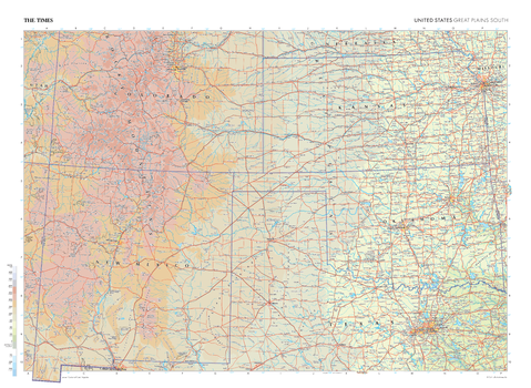
The Times Map of the Great Plains South (United States)
This map of the US Great Plains South stands as a benchmark of cartographic excellence, sourced from the industry-leading Times Comprehensive Atlas of the World. Published in full colour, this map offers a comprehensive and updated view of the diverse landscapes that characterise this region. Encompassing states such as Texas, Colorado, New Mexico, and more, this map includes prominent features such as the Great Plains and the Rocky Mountains. With meticulous attention to detail, this map is an indispensable guide to the geographic intricacies of the US Southern Great Plains.
Page Size: 36.5 x 26.75 in (924 x 675 mm)
The Times Map of the Great Plains South (United States) - Compact
This map of the US Great Plains South stands as a benchmark of cartographic excellence, sourced from the industry-leading Times Comprehensive Atlas of the World. Published in full colour, this map offers a comprehensive and updated view of the diverse landscapes that characterise this region. Encompassing states such as Texas, Colorado, New Mexico, and more, this map includes prominent features such as the Great Plains and the Rocky Mountains. With meticulous attention to detail, this map is an indispensable guide to the geographic intricacies of the US Southern Great Plains.
Page Size: 22.25 x 16.25 in (561 x 410 mm)
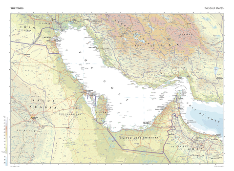
The Times Map of the Gulf States
This map of the Gulf States stands as a benchmark of cartographic excellence, sourced from the industry-leading Times Comprehensive Atlas of the World. Published in full colour, this map offers a comprehensive and updated view of the nations within this region, including: Iran, Saudi Arabia, Oman, the UAE, and Qatar. Prominent features such as the coastal cities along the Gulf, the desert landscapes, and key cities such as Dubai and Abu Dhabi are clearly identifiable. With meticulous attention to detail, this map is an indispensable guide to the geographic intricacies of the Gulf States.
Page Size: 36.5 x 26.75 in (924 x 675 mm)
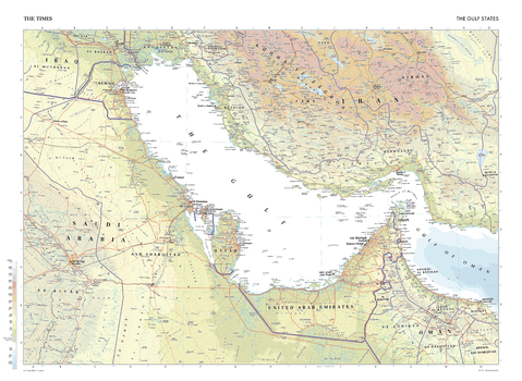
The Times Map of the Gulf States - Compact
This map of the Gulf States stands as a benchmark of cartographic excellence, sourced from the industry-leading Times Comprehensive Atlas of the World. Published in full colour, this map offers a comprehensive and updated view of the nations within this region, including: Iran, Saudi Arabia, Oman, the UAE, and Qatar. Prominent features such as the coastal cities along the Gulf, the desert landscapes, and key cities such as Dubai and Abu Dhabi are clearly identifiable. With meticulous attention to detail, this map is an indispensable guide to the geographic intricacies of the Gulf States.
Page Size: 22.25 x 16.25 in (561 x 410 mm)
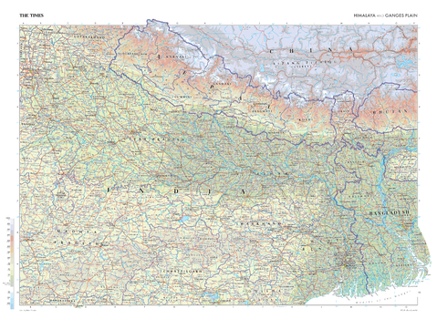
The Times Map of the Himalaya and Ganges Plain
This map of the Himalaya and Ganges Plain stands as a benchmark of cartographic excellence, sourced from the industry-leading Times Comprehensive Atlas of the World. Published in full colour, this map offers a comprehensive and updated view of the dramatic landscapes that define this region. Prominent features such as the towering peaks of the Himalayas, the expanse of the Ganges Plain, and key cities such as Dhaka and Kolkata are clearly identifiable. With meticulous attention to detail, this map is an indispensable guide to the geographic intricacies and natural wonders of the Himalaya and Ganges Plain.
Page Size: 36.5 x 26.75 in (924 x 675 mm)

The Times Map of the Himalaya and Ganges Plain - Compact
This map of the Himalaya and Ganges Plain stands as a benchmark of cartographic excellence, sourced from the industry-leading Times Comprehensive Atlas of the World. Published in full colour, this map offers a comprehensive and updated view of the dramatic landscapes that define this region. Prominent features such as the towering peaks of the Himalayas, the expanse of the Ganges Plain, and key cities such as Dhaka and Kolkata are clearly identifiable. With meticulous attention to detail, this map is an indispensable guide to the geographic intricacies and natural wonders of the Himalaya and Ganges Plain.
Page Size: 22.25 x 16.25 in (561 x 410 mm)

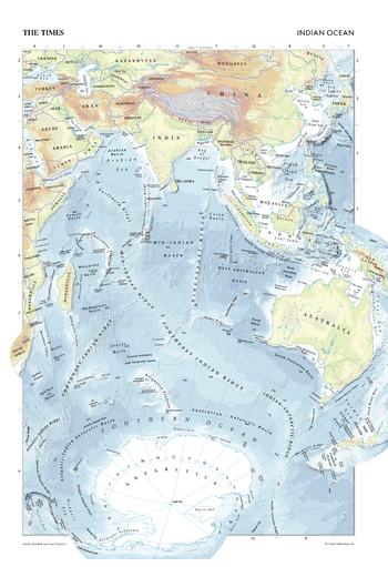
The Times Map of the Indian Ocean
This map of the Indian Ocean stands as a benchmark of cartographic excellence, sourced from the industry-leading Times Comprehensive Atlas of the World. Published in full colour, this map offers a comprehensive and updated view of the diverse seascapes and features that define this vast ocean. Encompassing the waters between the continents of Africa, Asia, Australia, and Antarctica, this map displays the ridges, basins and plateaus under the Indian Ocean. With meticulous attention to detail, this map is an indispensable guide to the geographic intricacies and highlights of the Indian Ocean.
Page Size: 18.25 x 26.75 in (462 x 675 mm)
The Times Map of the Indian Ocean - Compact
This map of the Indian Ocean stands as a benchmark of cartographic excellence, sourced from the industry-leading Times Comprehensive Atlas of the World. Published in full colour, this map offers a comprehensive and updated view of the diverse seascapes and features that define this vast ocean. Encompassing the waters between the continents of Africa, Asia, Australia, and Antarctica, this map displays the ridges, basins and plateaus under the Indian Ocean. With meticulous attention to detail, this map is an indispensable guide to the geographic intricacies and highlights of the Indian Ocean.
Page Size: 11.25 x 16.25 in (281 x 410 mm)
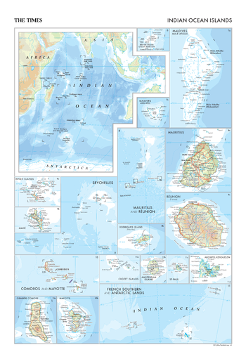
The Times Map of the Indian Ocean Islands
This map of Indian Ocean islands stands as a benchmark of cartographic excellence, sourced from the industry-leading Times Comprehensive Atlas of the World. Published in full colour, this map offers a comprehensive and updated view of the diverse islands that dot the Indian Ocean, such as the Maldives, Seychelles and Mauritius. Encompassing islands in situ within the ocean, as well as providing more than 15 detailed insets of key islands, this map provides a clear representation of the distribution and features of these islands. With meticulous attention to detail, this map is an indispensable guide to the geographic intricacies and highlights of the Indian Ocean islands.
Page Size: 18.25 x 26.75 in (462 x 675 mm)
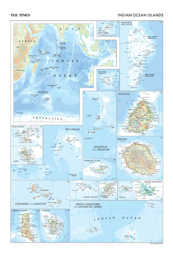
The Times Map of the Indian Ocean Islands - Compact
This map of Indian Ocean islands stands as a benchmark of cartographic excellence, sourced from the industry-leading Times Comprehensive Atlas of the World. Published in full colour, this map offers a comprehensive and updated view of the diverse islands that dot the Indian Ocean, such as the Maldives, Seychelles and Mauritius. Encompassing islands in situ within the ocean, as well as providing more than 15 detailed insets of key islands, this map provides a clear representation of the distribution and features of these islands. With meticulous attention to detail, this map is an indispensable guide to the geographic intricacies and highlights of the Indian Ocean islands.
Page Size: 11.25 x 16.25 in (281 x 410 mm)

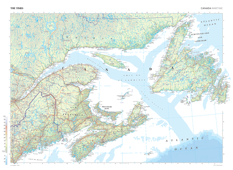
The Times Map of the Maritimes (Canada)
This map of The Maritimes stands as a benchmark of cartographic excellence, sourced from the industry-leading Times Comprehensive Atlas of the World. Published in full colour, this map offers a comprehensive and updated view of the landscapes that are found in this region. Encompassing the Maritime provinces of Nova Scotia, New Brunswick, and Prince Edward Island, the map also includes mapping of nearby Newfoundland and Labrador. With meticulous attention to detail, this map is an indispensable guide to the geographic intricacies of the Canadian Maritime provinces.
Page Size: 36.5 x 26.75 in (924 x 675 mm)
The Times Map of the Maritimes (Canada) - Compact
This map of The Maritimes stands as a benchmark of cartographic excellence, sourced from the industry-leading Times Comprehensive Atlas of the World. Published in full colour, this map offers a comprehensive and updated view of the landscapes that are found in this region. Encompassing the Maritime provinces of Nova Scotia, New Brunswick, and Prince Edward Island, the map also includes mapping of nearby Newfoundland and Labrador. With meticulous attention to detail, this map is an indispensable guide to the geographic intricacies of the Canadian Maritime provinces.
Page Size: 22.25 x 16.25 in (561 x 410 mm)