


The Times

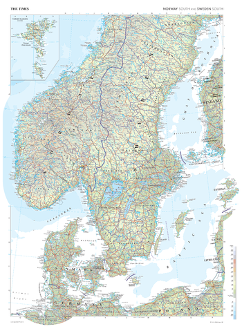
The Times Map of Scandinavia (South)
This map of South Scandinavia stands as a benchmark of cartographic excellence, sourced from the industry-leading Times Comprehensive Atlas of the World. Published in full colour, this map offers a comprehensive and updated view of the landscapes that are found in this region. With coverage of Sweden, Denmark, Norway and Finland, and key cities such as Copenhagen, Stockholm and Oslo clearly identifiable, this map is an indispensable guide to South Scandinavia. An additional inset map of the Faroe Islands (Denmark) adds further detail.
Page Size: 26.75 x 36.5 in (675 x 924 mm)
The Times Map of Scandinavia (South) - Compact
This map of South Scandinavia stands as a benchmark of cartographic excellence, sourced from the industry-leading Times Comprehensive Atlas of the World. Published in full colour, this map offers a comprehensive and updated view of the landscapes that are found in this region. With coverage of Sweden, Denmark, Norway and Finland, and key cities such as Copenhagen, Stockholm and Oslo clearly identifiable, this map is an indispensable guide to South Scandinavia. An additional inset map of the Faroe Islands (Denmark) adds further detail.
Page Size: 16.25 x 22.25 in (410 x 561 mm)
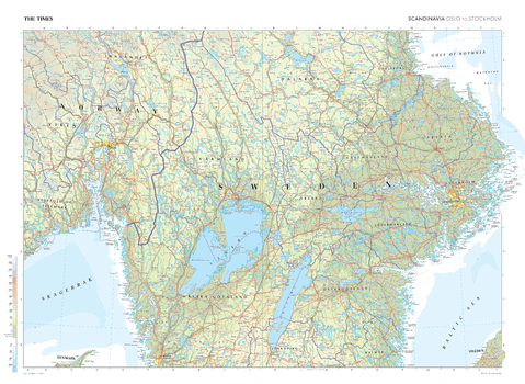
The Times Map of Scandinavia: Oslo to Stockholm
This map covering the distance from Oslo to Stockholm stands as a benchmark of cartographic excellence, sourced from the industry-leading Times Comprehensive Atlas of the World. Published in full colour, this map offers a comprehensive and updated view of the landscapes that connect these two vibrant cities. Prominent features such as the Vänern and Vättern lakes are clearly identifiable. With meticulous attention to detail, this map is an indispensable guide to the geographic intricacies from Oslo to Stockholm.
Page Size: 36.5 x 26.75 in (924 x 675 mm)
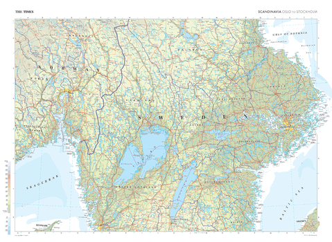
The Times Map of Scandinavia: Oslo to Stockholm - Compact
This map covering the distance from Oslo to Stockholm stands as a benchmark of cartographic excellence, sourced from the industry-leading Times Comprehensive Atlas of the World. Published in full colour, this map offers a comprehensive and updated view of the landscapes that connect these two vibrant cities. Prominent features such as the Vänern and Vättern lakes are clearly identifiable. With meticulous attention to detail, this map is an indispensable guide to the geographic intricacies from Oslo to Stockholm.
Page Size: 22.25 x 16.25 in (561 x 410 mm)
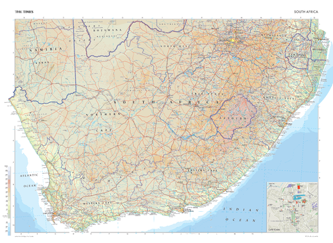
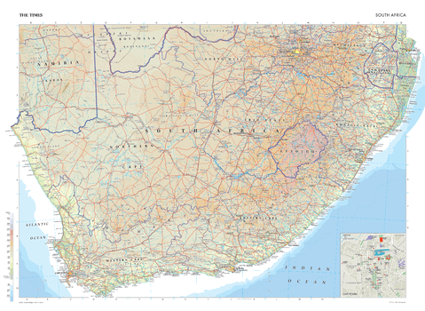
The Times Map of South Africa
This map of the Republic of South Africa stands as a benchmark of cartographic excellence, sourced from the industry-leading Times Comprehensive Atlas of the World. Published in full colour, this map offers a comprehensive and updated view of the landscapes that are found in this region. Prominent features such as the Drakensberg mountain range, the vibrant cities of Johannesburg, Pretoria and Durham are clearly identifiable. Notably, the map includes a city plan of the capital city Cape Town, adding an extra layer of detail to this city. Mapping also covers Lesotho and Eswatini and parts of Namibia. With meticulous attention to detail, this map is an indispensable guide to the geographic intricacies of the Republic of South Africa.
Page Size: 36.5 x 26.75 in (924 x 675 mm)
The Times Map of South Africa - Compact
This map of the Republic of South Africa stands as a benchmark of cartographic excellence, sourced from the industry-leading Times Comprehensive Atlas of the World. Published in full colour, this map offers a comprehensive and updated view of the landscapes that are found in this region. Prominent features such as the Drakensberg mountain range, the vibrant cities of Johannesburg, Pretoria and Durham are clearly identifiable. Notably, the map includes a city plan of the capital city Cape Town, adding an extra layer of detail to this city. Mapping also covers Lesotho and Eswatini and parts of Namibia. With meticulous attention to detail, this map is an indispensable guide to the geographic intricacies of the Republic of South Africa.
Page Size: 22.25 x 16.25 in (561 x 410 mm)
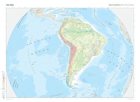
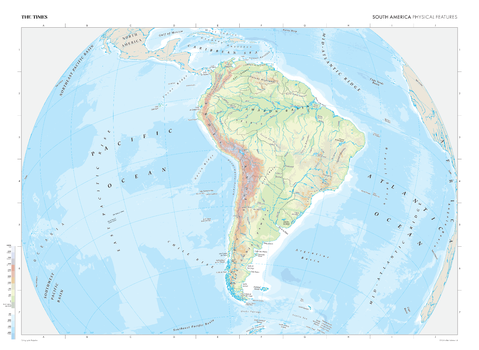
The Times Map of South America (Physical Features)
This map of South America's physical features stands as a benchmark of cartographic excellence, sourced from the industry-leading Times Comprehensive Atlas of the World. Published in full colour, this map offers a comprehensive and updated view of the diverse landscapes and geographical attributes that characterise the South American continent. Encompassing the towering Andes mountains, dense Amazon rainforest, extensive river systems, lakes, and key landforms, this map provides a clear representation of South America's natural features. With meticulous attention to detail, this map is an indispensable guide to the geographic intricacies and highlights of South America's physical characteristics.
Page Size: 36.5 x 26.75 in (924 x 675 mm)
The Times Map of South America (Physical Features) - Compact
This map of South America's physical features stands as a benchmark of cartographic excellence, sourced from the industry-leading Times Comprehensive Atlas of the World. Published in full colour, this map offers a comprehensive and updated view of the diverse landscapes and geographical attributes that characterise the South American continent. Encompassing the towering Andes mountains, dense Amazon rainforest, extensive river systems, lakes, and key landforms, this map provides a clear representation of South America's natural features. With meticulous attention to detail, this map is an indispensable guide to the geographic intricacies and highlights of South America's physical characteristics.
Page Size: 22.25 x 16.25 in (561 x 410 mm)

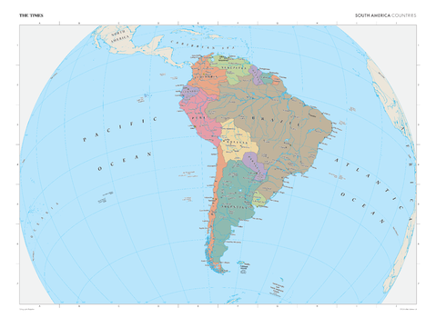
The Times Map of South America (Political Features)
This map of South America's political boundaries stands as a benchmark of cartographic excellence, sourced from the industry-leading Times Comprehensive Atlas of the World. Published in full colour, this map offers a comprehensive and updated view of the countries, cities, and political divisions that make up the South American continent. Encompassing the intricate national borders, capital cities, and key urban centres, this map provides a clear representation of South America's political landscape. With meticulous attention to detail, this map is an indispensable guide to the geographic intricacies and highlights of South America's political composition.
Page Size: 36.5 x 26.75 in (924 x 675 mm)
The Times Map of South America (Political Features) - Compact
This map of South America's political boundaries stands as a benchmark of cartographic excellence, sourced from the industry-leading Times Comprehensive Atlas of the World. Published in full colour, this map offers a comprehensive and updated view of the countries, cities, and political divisions that make up the South American continent. Encompassing the intricate national borders, capital cities, and key urban centres, this map provides a clear representation of South America's political landscape. With meticulous attention to detail, this map is an indispensable guide to the geographic intricacies and highlights of South America's political composition.
Page Size: 22.25 x 16.25 in (561 x 410 mm)

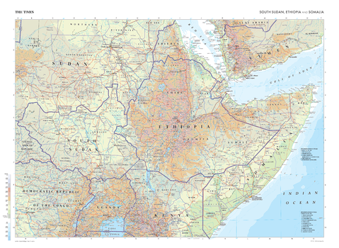
The Times Map of South Sudan, Ethiopia and Somalia
This map of South Sudan, Ethiopia, and Somalia stands as a benchmark of cartographic excellence, sourced from the industry-leading Times Comprehensive Atlas of the World. Published in full colour, this map offers a comprehensive and updated view of the landscapes that are found in this region. Prominent features such as the historic cities of Addis Abeba, Nairobi and Khartoum are clearly identifiable, as are the international borders. Additional mapping covers parts of Kenya, Democratic Republic of the Congo, Yemen, and Sudan. With meticulous attention to detail, this map is an indispensable guide to the geographic intricacies of South Sudan, Ethiopia, and Somalia.
Page Size: 36.5 x 26.75 in (924 x 675 mm)
The Times Map of South Sudan, Ethiopia and Somalia - Compact
This map of South Sudan, Ethiopia, and Somalia stands as a benchmark of cartographic excellence, sourced from the industry-leading Times Comprehensive Atlas of the World. Published in full colour, this map offers a comprehensive and updated view of the landscapes that are found in this region. Prominent features such as the historic cities of Addis Abeba, Nairobi and Khartoum are clearly identifiable, as are the international borders. Additional mapping covers parts of Kenya, Democratic Republic of the Congo, Yemen, and Sudan. With meticulous attention to detail, this map is an indispensable guide to the geographic intricacies of South Sudan, Ethiopia, and Somalia.
Page Size: 22.25 x 16.25 in (561 x 410 mm)
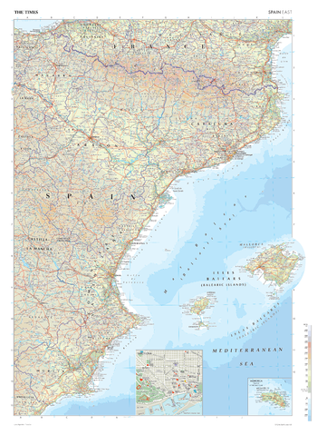
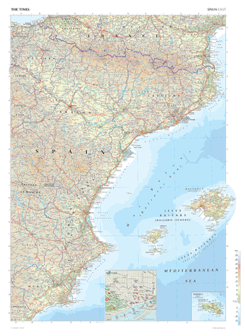
The Times Map of Spain (East)
This map of Eastern Spain stands as a benchmark of cartographic excellence, sourced from the industry-leading Times Comprehensive Atlas of the World. Published in full colour, this map offers a comprehensive and updated view of the landscapes that are found in this area. Prominent features such as the historic cities of Valencia, Barcelona, and the Balearic Islands are clearly identifiable. Notably, the map includes a scale inset of Menorca and detailed city plan of Barcelona, adding an extra layer of detail to these areas. With meticulous attention to detail, this map is an indispensable guide to the geographic intricacies of Eastern Spain.
Page Size: 26.75 x 36.5 in (675 x 924 mm)
The Times Map of Spain (East) - Compact
This map of Eastern Spain stands as a benchmark of cartographic excellence, sourced from the industry-leading Times Comprehensive Atlas of the World. Published in full colour, this map offers a comprehensive and updated view of the landscapes that are found in this area. Prominent features such as the historic cities of Valencia, Barcelona, and the Balearic Islands are clearly identifiable. Notably, the map includes a scale inset of Menorca and detailed city plan of Barcelona, adding an extra layer of detail to these areas. With meticulous attention to detail, this map is an indispensable guide to the geographic intricacies of Eastern Spain.
Page Size: 16.25 x 22.25 in (410 x 561 mm)
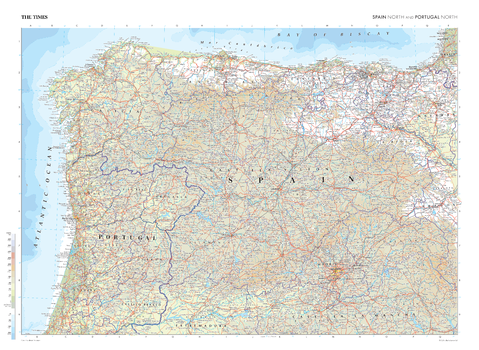
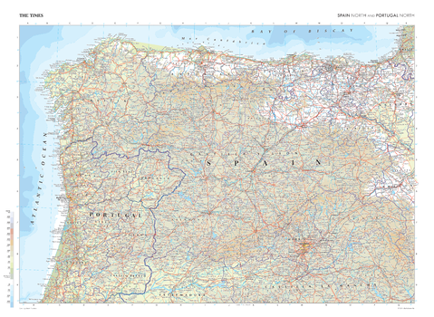
The Times Map of Spain (North) and Portugal (North)
This map of northern Spain and Portugal stands as a benchmark of cartographic excellence, sourced from the industry-leading Times Comprehensive Atlas of the World. Published in full colour, this map offers a comprehensive and updated view of the landscapes that are found in this region. Prominent features such as the historic capital cities of Madrid and Porto are clearly identifiable, as are the international and regional boundaries. With meticulous attention to detail, this map is an indispensable guide to the geographic intricacies of northern Spain and Portugal.
Page Size: 36.5 x 26.75 in (924 x 675 mm)
The Times Map of Spain (North) and Portugal (North) - Compact
This map of northern Spain and Portugal stands as a benchmark of cartographic excellence, sourced from the industry-leading Times Comprehensive Atlas of the World. Published in full colour, this map offers a comprehensive and updated view of the landscapes that are found in this region. Prominent features such as the historic capital cities of Madrid and Porto are clearly identifiable, as are the international and regional boundaries. With meticulous attention to detail, this map is an indispensable guide to the geographic intricacies of northern Spain and Portugal.
Page Size: 22.25 x 16.25 in (561 x 410 mm)
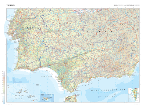
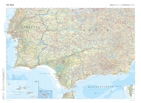
The Times Map of Spain (South) and Portugal (South)
This map of southern Spain and Portugal stands as a benchmark of cartographic excellence, sourced from the industry-leading Times Comprehensive Atlas of the World. Published in full colour, this map offers a comprehensive and updated view of the landscapes that are found in this region. Prominent features such as the vibrant cities of Seville, Lisbon, and the marshlands of Las Marismas are clearly identifiable. Notably, the map includes insets of Gibraltar, Madeira, and the Azores, adding an extra layer of detail to these distinctive areas. With meticulous attention to detail, this map is an indispensable guide to the geographic intricacies of southern Spain and Portugal.
Page Size: 36.5 x 26.75 in (924 x 675 mm)
The Times Map of Spain (South) and Portugal (South) - Compact
This map of southern Spain and Portugal stands as a benchmark of cartographic excellence, sourced from the industry-leading Times Comprehensive Atlas of the World. Published in full colour, this map offers a comprehensive and updated view of the landscapes that are found in this region. Prominent features such as the vibrant cities of Seville, Lisbon, and the marshlands of Las Marismas are clearly identifiable. Notably, the map includes insets of Gibraltar, Madeira, and the Azores, adding an extra layer of detail to these distinctive areas. With meticulous attention to detail, this map is an indispensable guide to the geographic intricacies of southern Spain and Portugal.
Page Size: 22.25 x 16.25 in (561 x 410 mm)

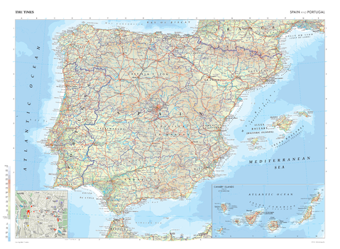
The Times Map of Spain and Portugal
This map of Spain and Portugal is a benchmark of cartographic excellence, taken from the industry leading Times Comprehensive Atlas of the World. There is a high level of detail packed into the map, yet the positioning of every element is carefully chosen to make the map coherent and attractive. Major cities including Barcelona, Porto and Sevilla are easily identifiable, as are the capitals of Madrid and Lisbon. International borders are clearly marked as are regional boundaries within both countries. Geographical features such as the Pyrenees Mountain range are clearly marked. Additional inset maps provide further detailing of the Canary Islands and a road map of Madrid.
Page Size: 36.5 x 26.75 in (924 x 675 mm)
The Times Map of Spain and Portugal - Compact
This map of Spain and Portugal is a benchmark of cartographic excellence, taken from the industry leading Times Comprehensive Atlas of the World. There is a high level of detail packed into the map, yet the positioning of every element is carefully chosen to make the map coherent and attractive. Major cities including Barcelona, Porto and Sevilla are easily identifiable, as are the capitals of Madrid and Lisbon. International borders are clearly marked as are regional boundaries within both countries. Geographical features such as the Pyrenees Mountain range are clearly marked. Additional inset maps provide further detailing of the Canary Islands and a road map of Madrid.
Page Size: 22.25 x 16.25 in (561 x 410 mm)