National Geographic
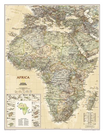
Africa Executive
Our executive-style political map of Africa features country boundaries, place names, bodies of water, airports, major highways and roads, and much more. Includes the most accurate and up to date boundaries and names for all countries including Algeria, Angola, Benin, Botswana, Burkina Faso, Burundi, Cameroon, Cape Verde, Central African Republic, Chad, Democratic Republic of the Congo, Republic of Congo, Côte d'Ivoire, Djibouti, Egypt, Equatorial Guinea, Eritrea, Ethiopia, Gabon, Gambia, Ghana, Guinea, Guinea-Bissau, Kenya, Liberia, Libya, Madagascar, Malawi, Mali, Mauritania, Morocco, Mozambique, Namibia, Niger, Nigeria, Rwanda, Senegal, Sierra Leone, Somalia, South Africa, Sudan, South Sudan, Tanzania, Togo, Tunisia, Uganda, Zambia, Zimbabwe and the island nations off the coast of Africa.
Page Size: 24 x 31 in (610 x 784 mm)
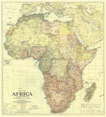
Africa Map with portions of Europe and Asia - Published 1922
In October 1922, National Geographic devoted an entire issue to the continent of Africa which included this beautifully crafted map. Discover Africa in the early 20th century when transportation on the continent was in its infancy and many rivers were yet unexplored.
Page Size: 28.5 x 31.5 in (721 x 798 mm)
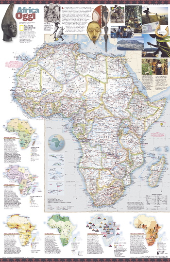
Africa Oggi - Published 2001
Published in September 2001, this attractive map of Africa translated into Italian contains a wealth of information about the enigmatic continent.
Page Size: 20.25 x 31.25 in (514 x 794 mm)
Africa Physical - Atlas of the World, 10th Edition
null
Page Size: 28 x 22 in (711 x 559 mm)

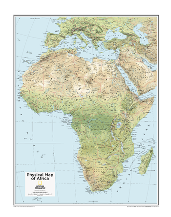
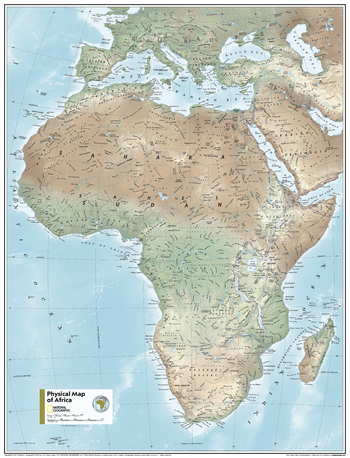
Africa Physical - Atlas of the World, 11th Edition
This map of physical features can fit in any space. Showcasing Africa in stunning detail with state-of-the-art cartographic techniques delivering accuracy and exceptional quality, the innovative and engaging design makes the content easily accessible and user-friendly.
Ideal for classrooms with an emphasis on teaching geography or environmental themes. The inclusion of physical features on this wall map gives your students a genuine feel for how our world appears.
This physical map of Africa uses a bright, easy to read color palette featuring blue oceans and stunning shaded relief that has been featured on National Geographic wall maps for over 75 years. Drawn in the Azimuthal Equidistant projection, this map ensures that all points on the map are at proportionally correct distances from the center point.
Names of geographic features such as international boundaries, cities, rivers and lakes are carefully placed on the map to maintain legibility.
This map is found in National Geographic's 11th Edition World Atlas and is now available as a stand alone product.
Page Size: 24 x 31.5 in (610 x 798 mm)
Africa Physical - Atlas of the World, 11th Edition - Compact
This map of physical features can fit in any space. Showcasing Africa in stunning detail with state-of-the-art cartographic techniques delivering accuracy and exceptional quality, the innovative and engaging design makes the content easily accessible and user-friendly.
Ideal for classrooms with an emphasis on teaching geography or environmental themes. The inclusion of physical features on this wall map gives your students a genuine feel for how our world appears.
This physical map of Africa uses a bright, easy to read color palette featuring blue oceans and stunning shaded relief that has been featured on National Geographic wall maps for over 75 years. Drawn in the Azimuthal Equidistant projection, this map ensures that all points on the map are at proportionally correct distances from the center point.
Names of geographic features such as international boundaries, cities, rivers and lakes are carefully placed on the map to maintain legibility.
This map is found in National Geographic's 11th Edition World Atlas and is now available as a stand alone product.
Page Size: 16.25 x 21.5 in (413 x 540 mm)
Africa Political - Atlas of the World, 10th Edition
null
Page Size: 28 x 22 in (711 x 559 mm)
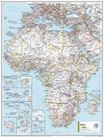
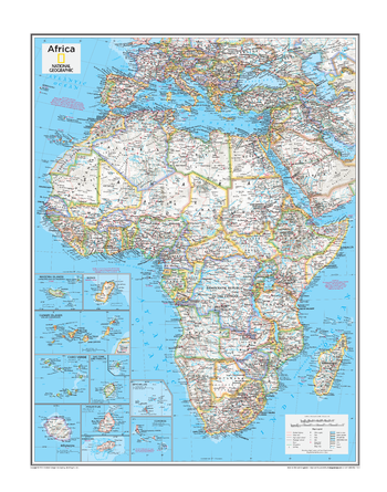
Africa Political - Atlas of the World, 11th Edition
This map of political features can fit in any space. Showcasing Africa in stunning detail with state-of-the-art cartographic techniques delivering accuracy and exceptional quality, the innovative and engaging design makes the content easily accessible and user-friendly.
Ideal for classrooms with an emphasis on teaching geography or environmental themes. The inclusion of physical features on this map gives your students a genuine feel for how the African continent appears.
This political map of Africa uses a bright, easy to read color palette featuring blue oceans and stunning shaded relief that has been featured on National Geographic wall maps for over 75 years. This map includes insets of the islands sprinkled off of Africa's coast. Drawn in the Azimuthal Equidistant projection, this map ensures that all points on the map are at proportionally correct distances from the center point.
Names of geographic features such as international boundaries, cities, rivers and lakes are carefully placed on the map to maintain legibility.
This map is found in National Geographic's 11th Edition World Atlas and is now available as a stand alone product.
Page Size: 24 x 31.5 in (610 x 798 mm)
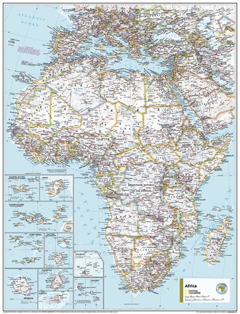
Africa Political - Atlas of the World, 11th Edition - Compact
This map of political features can fit in any space. Showcasing Africa in stunning detail with state-of-the-art cartographic techniques delivering accuracy and exceptional quality, the innovative and engaging design makes the content easily accessible and user-friendly.
Ideal for classrooms with an emphasis on teaching geography or environmental themes. The inclusion of physical features on this map gives your students a genuine feel for how the African continent appears.
This political map of Africa uses a bright, easy to read color palette featuring blue oceans and stunning shaded relief that has been featured on National Geographic wall maps for over 75 years. This map includes insets of the islands sprinkled off of Africa's coast. Drawn in the Azimuthal Equidistant projection, this map ensures that all points on the map are at proportionally correct distances from the center point.
Names of geographic features such as international boundaries, cities, rivers and lakes are carefully placed on the map to maintain legibility.
This map is found in National Geographic's 11th Edition World Atlas and is now available as a stand alone product.
Page Size: 16.25 x 21.5 in (413 x 540 mm)
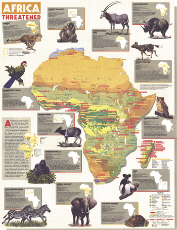
Africa Threatened - Published 1990
Africa began the 1970s with nearly 70,000 Black Rhinos and ended the 1980s with about 3,000. Their near extinction is but one illustration of the serious threats to African fauna detailed in this colorful and educational map. Published in December of 1990 as a companion to the "Africa" map and three articles on Africa including "A Gathering of Waters and Wildlife".
Page Size: 22.25 x 28.75 in (560 x 726 mm)
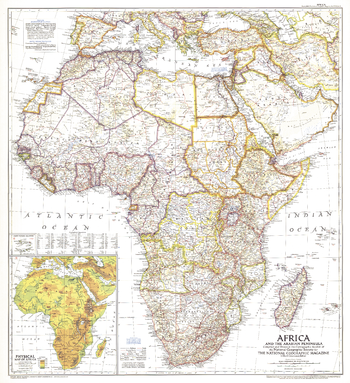
Africa and the Arabian Peninsula - Published 1950
This intriguing historical snapshot of Africa and the Arabian Peninsula captures Libya and Somalia's independence from colonial administration as well as early oil development in Saudi Arabia, Iraq, and Iran. First published in March 1950, this map accompanied three National Geographic articles including one entitled, "Roaming Africa's Unfenced Zoos."
Page Size: 28.5 x 31.25 in (720 x 788 mm)
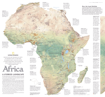
Africa, A Storied Landscape - Published 2005
From the first cautious steps in the Great Rift Valley, humans have adapted to the challenges of Africa. Today it lies divided into more nations than any other continent. But as shown by this satellite-derived map, landscapes that ignore national borders form a mosaic of ecosystems that subtly blend one into the other -- from the temperate Mediterranean through desert and scattered croplands to forest, swamp, and savanna -- each with its own rules for life. Published in September 2005 as half of a two–map set with "Africa: The Human Footprint."
Page Size: 24.25 x 22.25 in (616 x 565 mm)
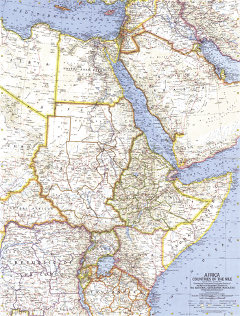
Africa, Countries of the Nile - Published 1963
This map of the Nile countries of Africa was created before completion of the Aswan High Dam in southern Egypt. Published in October 1963 with the articles "Threatened Treasures of the Nile" and "Tutankhamun's Golden Trove."
Page Size: 19 x 25 in (480 x 631 mm)
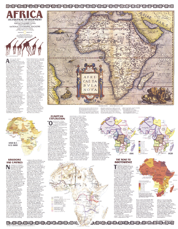
Africa, Its Political Development - Published 1980
Anchored by a map originally crafted on canvas by Flemish cartographer Ortelius in the year 1750, this series of maps and explanations provides an astounding yet succinct overview of the political development of Africa.
Page Size: 22.75 x 29.25 in (578 x 741 mm)
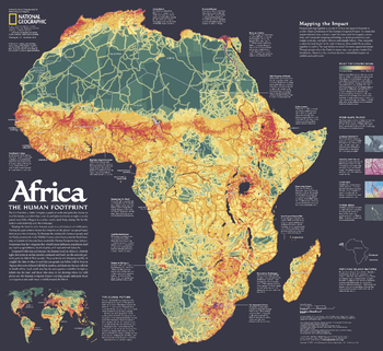
Africa, the Human Footprint - Published 2005
Shaping the land to serve human needs is a cornerstone of civilization. During the past century, humanity's footprint on the planet has spread faster than at any other time in history. To illustrate the relationship between people and the Earth, scientists from the Wildlife Conservation Society and the Earth Institute at Columbia University have created the Human Footprint map. Published in September 2005 as half of a two–map set with "Africa: A Storied Landscape."
Page Size: 24.5 x 22.5 in (617 x 566 mm)
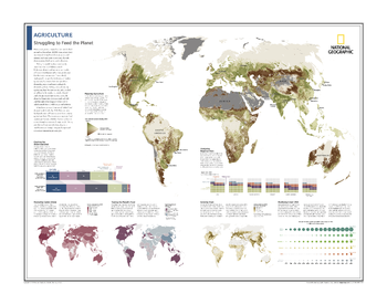
Agriculture: Struggling to Feed the Planet - Atlas of the World, 10th Edition
Mapping Agriculture; Charting the Undernourished; Measuring Caloric Intake; Trading the Planet's Food; Analyzing Regional Diets; Growing Grain; Modifying Crops' DNA
Page Size: 28 x 22 in (711 x 559 mm)
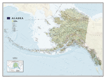
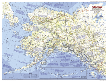
Alaska
One of the largest and most detailed maps available for the North Star State. Rich shaded relief makes Alaska's incredibly diverse terrain easy to visualize and remarkably beautiful.<br><br>The map includes hundreds of named places including primary and secondary towns, political boundaries, infrastructure, hydrography, national parks, state parks, wilderness areas, major peaks, military reservations, and more. It shows Alaska in its entirety, including the entire 2,200 mile Aleutian Island chain that when mapping it in detail, cartographers almost always break it into sections for convenience. This map, however, portrays the entire State at the same scale on one wide sheet – offering an unparalleled perspective on Alaska's true size. Also found on the map is an inset map, in the lower left-hand corner, which displays Alaska's relative size to the conterminous U.S.
Page Size: 40.5 x 30.25 in (1029 x 768 mm)
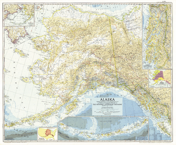
Alaska - Published 1956
This Alaska map features several detailed insets of such areas as the Inside Passage and the Aleutian Islands. A relative size comparison of Alaska and the United States demonstrates that if the state's westernmost point were superimposed on the California coast, its easternmost point would be on the east coast of South Carolina. Published in June 1956 in the same year that Alaska, then a territory of the United States, ratified its constitution.
Page Size: 35 x 29 in (887 x 733 mm)
Alaska - Published 1984
The largest state in the United States, Alaska is home to some of the most pristine wilderness in the world. Explore the region with this informative map, featuring attractive mountain relief and a wealth of historical notes. Published in 1984 as part of the "Making of America" series.
Page Size: 27.25 x 20.5 in (686 x 516 mm)
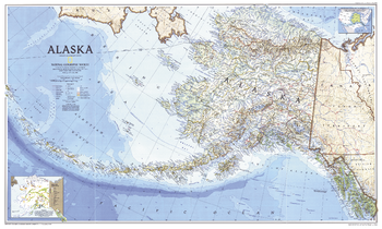
Alaska - Published 1994
Cartographers usually break Alaska up into sections, but this unique map shows all of the state, more than 2,200 miles from the tip of the panhandle to the outermost Aleutian Island, in the same scale on one, wide sheet. Published in May 1994.
Page Size: 37 x 22.25 in (935 x 560 mm)