


MapSherpa
World Imagery
Based on Mapbox Satellite which provides highly-detailed imagery for the whole world. Appropriate for mapping starting at 1:10,000 and up.
World Imagery Hybrid
Based on Mapbox Satellite with OpenStreetMap street visualization for the whole world. Appropriate for mapping starting at 1:10,000 and up.

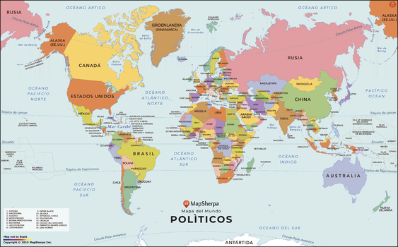
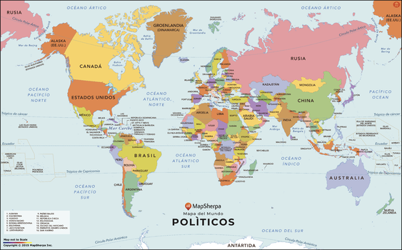
World Map with Countries in Spanish
A modern World Map in Spanish. Strong color use makes distinguishing each country very easy, and all the labels are in Spanish. The map is clean and clear, and labels all the countries and the most prominent water features. In areas where the countries are too small and or tightly packed to label clearly, a numbering system is used with a corresponding legend in the lower left.
Page Size: 36 x 22.5 in (914 x 569 mm)

World Map with Countries in Spanish - Compact
A modern World Map in Spanish. Strong color use makes distinguishing each country very easy, and all the labels are in Spanish. The map is clean and clear, and labels all the countries and the most prominent water features. In areas where the countries are too small and or tightly packed to label clearly, a numbering system is used with a corresponding legend in the lower left.
Page Size: 26.25 x 16.25 in (664 x 413 mm)
World Map with Countries in Spanish - Extra Large
A modern World Map in Spanish. Strong color use makes distinguishing each country very easy, and all the labels are in Spanish. The map is clean and clear, and labels all the countries and the most prominent water features. In areas where the countries are too small and or tightly packed to label clearly, a numbering system is used with a corresponding legend in the lower left.
Page Size: 64.5 x 40 in (1634 x 1016 mm)
World Map with Countries in Spanish - Large
A modern World Map in Spanish. Strong color use makes distinguishing each country very easy, and all the labels are in Spanish. The map is clean and clear, and labels all the countries and the most prominent water features. In areas where the countries are too small and or tightly packed to label clearly, a numbering system is used with a corresponding legend in the lower left.
Page Size: 48 x 30 in (1219 x 758 mm)
World Modern Map - Compact
Introducing the MapSherpa Modern World Map, featuring a captivating display of unique colors. This meticulously designed map showcases the beauty of our political world in a contemporary and eye-catching way. With its vibrant hues and precise detailing, it serves as both a decorative piece and a functional tool for any geography enthusiast. Whether you are planning your next adventure or simply adding a touch of sophistication to your space, MapSherpa’s Modern world map is sure to impress.
Page Size: 22 x 16 in (559 x 406 mm)
World Modern Map - Poster
Introducing the MapSherpa Modern World Map, featuring a captivating display of unique colors. This meticulously designed map showcases the beauty of our political world in a contemporary and eye-catching way. With its vibrant hues and precise detailing, it serves as both a decorative piece and a functional tool for any geography enthusiast. Whether you are planning your next adventure or simply adding a touch of sophistication to your space, MapSherpa’s Modern world map is sure to impress.
Page Size: 36 x 24 in (914 x 610 mm)
World Physical
This physical map displays relief features on the earth by colouring the land elevations and water depths. International boundaries, major towns and cities are displayed with the country capitals clearly marked. Major airports, roads and railway networks are represented, depending on the scale of your map. These wall maps are suitable for home, office or the classroom. Custom maps can have a scale from approximately 1:500,000 to 1:40,000,000.
World Political
This political world map features countries marked in different colours, with international and regional boundaries shown. Major towns and cities are displayed with the country capitals clearly marked. Major airports, roads and railway networks are represented, depending on the scale of your map. These wall maps are suitable for home, office or the classroom. Custom maps can be made at scales between 1:500,000 to 1:40,000,000.
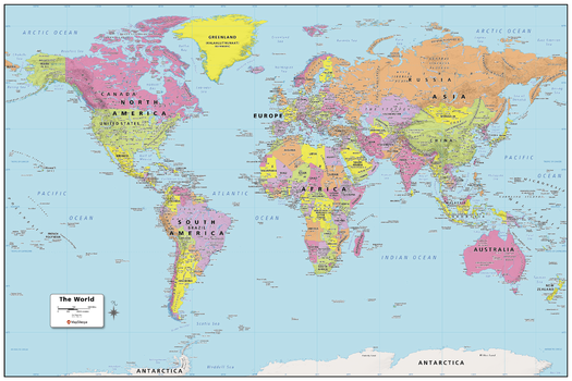
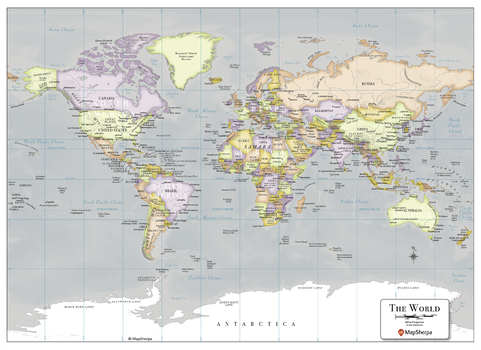
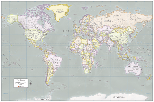
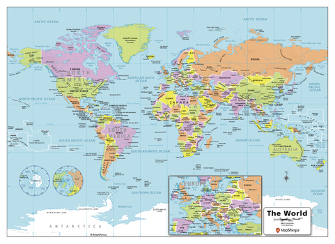
World Political Map
Created specifically for MapSherpa, this World Political Map shows all the countries and land areas that make up our world. Each country, its capital and major cities are noted, as well as the primary physical and water features such as; mountain ranges, rivers, and lakes. Disputed borders, the international date line as well as world time zones are noted. With multiple sizes available, this is the perfect reference map for home, office, or school use.
Page Size: 36 x 24 in (914 x 610 mm)

World Political Map - Large
Created specifically for MapSherpa, this World Political Map shows all the countries and land areas that make up our world. Each country, its capital and major cities are noted, as well as the primary physical and water features such as; mountain ranges, rivers, and lakes. Disputed borders, the international date line as well as world time zones are noted. With multiple sizes available, this is the perfect reference map for home, office, or school use.
Page Size: 48 x 32 in (1219 x 813 mm)
World Political Map - Compact
Created specifically for MapSherpa, this World Political Map shows all the countries and land areas that make up our world. Each country, its capital and major cities are noted, as well as the primary physical and water features such as; mountain ranges, rivers, and lakes. Disputed borders, the international date line as well as world time zones are noted. With multiple sizes available, this is the perfect reference map for home, office, or school use.
Page Size: 22 x 16 in (559 x 406 mm)
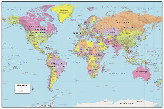
World Political Map - Extra Large
Created specifically for MapSherpa, this World Political Map shows all the countries and land areas that make up our world. Each country, its capital and major cities are noted, as well as the primary physical and water features such as; mountain ranges, rivers, and lakes. Disputed borders, the international date line as well as world time zones are noted. With multiple sizes available, this is the perfect reference map for home, office, or school use.
Page Size: 60 x 40 in (1524 x 1016 mm)
World Political with Relief
This political world map features countries marked in different colours, with international and regional boundaries shown. A hill shading texture enhances the visual appearance of the map. Major towns and cities are displayed with the country capitals clearly marked. Major airports, roads and railway networks are represented, depending on the scale of your map. These wall maps are suitable for home, office or the classroom. Custom maps can be made at scales between 1:500,000 to 1:40,000,000.
World Terrain
Based on Mapbox streets with terrain visualization; shaded relief and elevation contour lines atop OpenStreetMap land-use and land-cover information for the entire world. Appropriate for mapping starting at 1:10,000 and up.
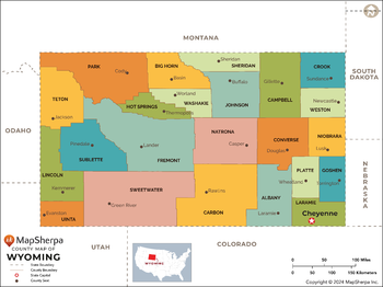
Wyoming Counties Map - Extra Large
This map has been created exclusively for MapSherpa, and designed for reference or business use. Clear and clean colors & fonts matched with cartographic research makes this map of the 23 Wyoming counties easily readable and useful.
Page Size: 60 x 45 in (1524 x 1140 mm)

Wyoming Counties Map - Large
This map has been created exclusively for MapSherpa, and designed for reference or business use. Clear and clean colors & fonts matched with cartographic research makes this map of the 23 Wyoming counties easily readable and useful.
Page Size: 48 x 36 in (1219 x 912 mm)

Wyoming Counties Map - Standard
This map has been created exclusively for MapSherpa, and designed for reference or business use. Clear and clean colors & fonts matched with cartographic research makes this map of the 23 Wyoming counties easily readable and useful.
Page Size: 36 x 27 in (914 x 684 mm)
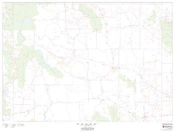
Wyoming ZIP Code Map
This map of Wyoming shows ZIP codes overlaid on a road map. Base map features include county boundaries, major road network features, and state and national parks and conservation areas.
Page Size: 48 x 36 in (1219 x 914 mm)