


MapSherpa
UK Roads
A multi-scale Road map product based on Ordnance Survey data and cartographic styles. Make a map of anywhere in England, Scotland and Wales. This product provides continuous coverage in the U.K between the scales of 1:10,000 and 1:1,000,000. Updated twice a year this product provides detailed ‘street level’ mapping. Features on the map can include; buildings, roads, railways, rivers, forests, place names and points of interest such as schools, hospitals, police and train stations.
UK Street View
This product provides Ordnance Survey street-level mapping that has been specifically designed to cartographically emphasize road carriageways, road names and their Department for Transport numbers. Major public buildings are also highlighted and annotated. Maps can be created at a range of scales between 1:5,000 and 1:15,000.
UK Street View - Fixed Scale
This product provides Ordnance Survey street-level mapping that has been specifically designed to cartographically emphasize road carriageways, road names and their Department for Transport numbers. Major public buildings are also highlighted and annotated. Maps can be created at a fixed scale of 1:10,000.
UK Streets Open Map
Make a map of anywhere in England, Scotland and Wales. This product provides continuous coverage in the U.K with optimal design at 1:10,000 scale. Updated twice a year this street level product highlights features that include buildings, roads, railways, rivers, forests, place names and points of interest such as schools, hospitals, police and train stations.This street map product has been cartographically optimized by the Ordnance Survey.
UK Streets Open Map Wallpaper
Make Wallpaper Maps based on the Ordnance Survey 1:10,000 Open Map - Local content.
UK Topographic
This product provides Ordnance Survey mapping for your leisure activities and outdoor recreation pursuits. Create maps for anywhere in the United Kingdom from the popular OS Explorer and OS Landranger series. The detailed mapping at large scales (most zoomed in) means that features such as walking routes or cycle trails are clearly displayed on the map. At regional scales the maps provide information on landscape features such as golf courses and National Trust properties. Maps include topographic detail with contour information. Maps can be created at a range of scales between 1:12,000 and 1:100,000.
UK Topographic - Fixed Scale
This product provides Ordnance Survey mapping for your leisure activities and outdoor recreation pursuits. Create maps for anywhere in the United Kingdom from the popular OS Explorer and OS Landranger series. The detailed mapping at large scales (most zoomed in) means that features such as walking routes or cycle trails are clearly displayed on the map. At regional scales the maps provide information on landscape features such as golf courses and National Trust properties. Maps include topographic detail with contour information. Maps can be created at fixed scales of 1:25,000 and 1:50,000.
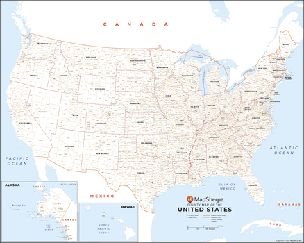
USA County Names Map
This map has been created exclusively for MapSherpa, and designed for reference or business use. Clear and clean colors & fonts matched with cartographic research makes this map of USA Map wth County Names easily readable and useful. The map shows the the over 3,000 counties, parishes and boroughs of the United States and their borders.
Page Size: 33.5 x 27 in (851 x 680 mm)
USA Explorer
This versatile product allows you to get a topo map of anywhere in the USA. It has been designed so you can create a map for your next outdoor adventure.This product has been designed to make custom topographic maps suitable for short hikes to week long back-country adventures or hunting trips and anything in between. Back-country roads and trails are featured prominently on this map along with key points of interest such as campsites, trailheads, and landmarks. Also included are traditional topographic features such as elevation contours, landforms, lakes, and rivers along with roads, rails, trails, and park boundaries.The details of this map make it ideal to plan an excursion and take it with you. Invaluable for outdoor recreation activities such as hunting, fishing, ATV, camping, hiking, and mountain biking.
USA Imagery
This product leverages the USGS National Agriculture Imagery Program (NAIP) imagery service from The National Map to generate natural colour maps of the Lower 48 US states.
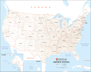
USA Map with County Names - Extra Large
This map has been created exclusively for MapSherpa, and designed for reference or business use. Clear and clean colors & fonts matched with cartographic research makes this map of USA Map wth County Names easily readable and useful. The map shows the the over 3,000 counties, parishes and boroughs of the United States and their borders.
Page Size: 60 x 48 in (1524 x 1217 mm)
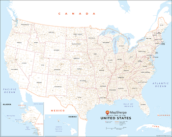
USA Map with County Names - Large
This map has been created exclusively for MapSherpa, and designed for reference or business use. Clear and clean colors & fonts matched with cartographic research makes this map of USA Map wth County Names easily readable and useful. The map shows the the over 3,000 counties, parishes and boroughs of the United States and their borders.
Page Size: 48 x 38.5 in (1219 x 974 mm)
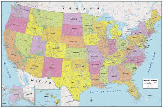
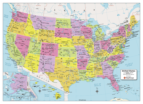
USA Political Map
Created specifically for MapSherpa, this United States Political Map stretches from the Pacific to the Atlantic Oceans, and the Gulf of Mexico to international neighbor borders, this US Political Map displays all 50 states that make up the country. For readability, each state is easily identified by a different color, the map prominently shows; State capitals, primary cities & towns, major national parks, primary water features, mountain ranges and all time zones. With multiple sizes available, this is the perfect reference map for home, office, or school use.
Page Size: 36 x 24 in (914 x 610 mm)
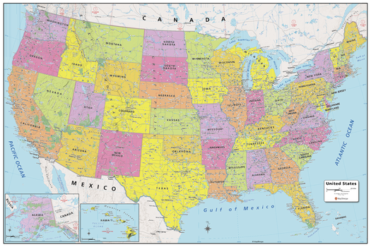
USA Political Map - Compact
Created specifically for MapSherpa, this United States Political Map stretches from the Pacific to the Atlantic Oceans, and the Gulf of Mexico to international neighbor borders, this US Political Map displays all 50 states that make up the country. For readability, each state is easily identified by a different color, the map prominently shows; State capitals, primary cities & towns, major national parks, primary water features, mountain ranges and all time zones. With multiple sizes available, this is the perfect reference map for home, office, or school use.
Page Size: 22 x 16 in (559 x 406 mm)
USA Political Map - Extra Large
Created specifically for MapSherpa, this United States Political Map stretches from the Pacific to the Atlantic Oceans, and the Gulf of Mexico to international neighbor borders, this US Political Map displays all 50 states that make up the country. For readability, each state is easily identified by a different color, the map prominently shows; State capitals, primary cities & towns, major national parks, primary water features, mountain ranges and all time zones. With multiple sizes available, this is the perfect reference map for home, office, or school use.
Page Size: 60 x 40 in (1524 x 1016 mm)
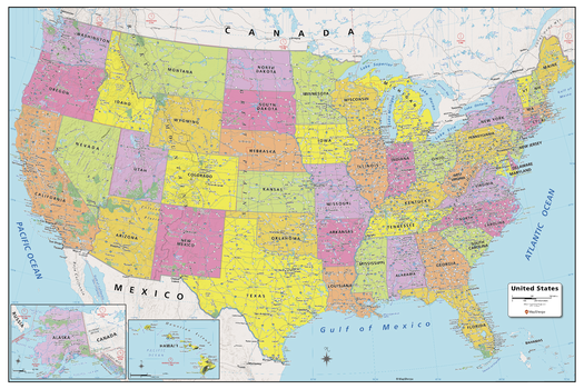
USA Political Map - Large
Created specifically for MapSherpa, this United States Political Map stretches from the Pacific to the Atlantic Oceans, and the Gulf of Mexico to international neighbor borders, this US Political Map displays all 50 states that make up the country. For readability, each state is easily identified by a different color, the map prominently shows; State capitals, primary cities & towns, major national parks, primary water features, mountain ranges and all time zones. With multiple sizes available, this is the perfect reference map for home, office, or school use.
Page Size: 48 x 32 in (1219 x 813 mm)
USA Roads and Recreation
This versatile product allows you to get a road map of anywhere in the USA. It has been designed so you can create a map for your next trip.This product has been designed to make custom road and street maps suitable for road trips and sightseeing. This map features comprehensive points of interest including attractions, landmarks, amenities, scenic views and local foot and bike paths. Also included is a complete network of highways, streets and roads you can count on.The details of this map make it ideal to plan a trip and take it with you. Travel with confidence using a map created specifically for the area you will be discovering.
USA Streets
The MapSherpa Street product is ideal for the Business owner who needs local or regional road network information within a service delivery, catchment area or a sales territory. Information on the map highlights Municipal, Town and Zip Code boundaries. This multi-scale product for the United States uses the most current TomTom map data; you can count on this map showing the latest changes in your area. This product has been designed to make custom maps suitable from city to county scales, and anywhere in between. Rich regional maps include display highway infrastructure including, interchanges, weigh stations and tolls. Full street labelling, block numbers and street direction afford detailed city level maps. Infrastructure such as airports, hospitals, shopping malls, exhibition centers, industrial complexes and other business centric features are easily identifiable on the map.
USA Streets Index
The MapSherpa Street product is ideal for the Business owner who needs local or regional road network information within a service delivery, catchment area or a sales territory. Information on the map highlights Municipal, Town and Zip Code boundaries. This multi-scale product for the United States uses the most current TomTom map data; you can count on this map showing the latest changes in your area. This product has been designed to make custom maps suitable from city to county scales, and anywhere in between. Rich regional maps include display highway infrastructure including, interchanges, weigh stations and tolls. Full street labelling, block numbers and street direction afford detailed city level maps. Infrastructure such as airports, hospitals, shopping malls, exhibition centers, industrial complexes and other business centric features are easily identifiable on the map.The map has an index grid (columns are labelled A, B, C, D… and rows are labelled 1, 2, 3, 4 …). The street index is provided as a separate Index file and lists the street name, address and grid coordinates. This multi-scale product for the United States is based on TomTom data and updated twice a year.
USA Terrain
This versatile product allows you to get a wall map of anywhere in the USA. It has been designed to create beautiful maps that emphasize the natural landscape around places important to you.This product has been designed to make custom wall maps suitable from your local area to the whole country, and anywhere in between. 3D terrain shading provides a sense of relief of the surrounding topography enhanced by traditional topographic features such as elevation contours, landforms, lakes, and rivers. Also included are roads, rails, trails, and park boundaries.The cartography beautifully captures your connection to the landscape making this map ideal for showing off cottages, resorts, lakes and other favourite places. Makes a perfect personalized gift or memento of your latest adventure.