


MapSherpa
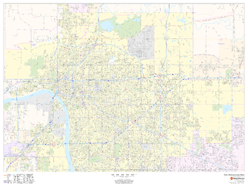
Tulsa, Oklahoma Inner Metro - Landscape
This landscape-oriented map of central Tulsa, Oklahoma shows detailed street level information including extensive street labeling. Ideal for planning of deliveries, home services, sales territories, real estate and much more. Base map features include all roads with major roads and highways labelled; neighborhood names; railways; high level land use such as parks and recreation areas, industrial areas and hospital campuses; and a variety of points of interest including schools, libraries, stadiums, museums, border crossings and more.
Page Size: 48 x 36 in (1219 x 914 mm)
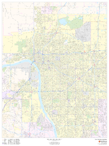
Tulsa, Oklahoma Inner Metro - Portrait
This portrait-oriented map of central Tulsa, Oklahoma shows detailed street level information including extensive street labeling. Ideal for planning of deliveries, home services, sales territories, real estate and much more. Base map features include all roads with major roads and highways labelled; neighborhood names; railways; high level land use such as parks and recreation areas, industrial areas and hospital campuses; and a variety of points of interest including schools, libraries, stadiums, museums, border crossings and more.
Page Size: 36 x 48 in (914 x 1219 mm)
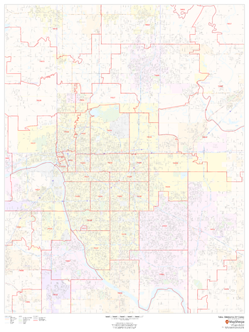
Tulsa, Oklahoma ZIP Codes
This map of Tulsa, Oklahoma shows ZIP code areas overlaid on a road map. Ideal for planning of deliveries, home services, sales territories, real estate and much more. Base map features include all roads with major roads and highways labelled; neighborhood names; railways; and high level land use such as parks and recreation areas, industrial areas and hospital campuses.
Page Size: 36 x 48 in (914 x 1219 mm)
UK Civil Parishes
These maps highlight the electoral geography of the United Kingdom. Clearly visible Civil Parish boundaries and names are overlain on an Ordnance Survey backdrop map. Maps can be made of local regions which illustrate street level boundaries , to regional areas which illustrate many Wards and the major roads and cities. Boundary-line data is updated bi-annually (spring and fall).
UK Detailed Topographic
Detailed national mapping based on Ordnance Survey Vector Map Local data with contours overlain at a 10m interval. Accurate, large scale mapping suitable for creating maps between 1:5,000 and 1:10,000 scales. Rich urban detail and street-level information which is easy to understand and suitable for public consultations about planning proposals. Features shown include roads, railways, watercourses, vegetation and land areas and boundaries.
UK Detailed Topographic - Fixed Scale
Detailed national mapping based on Ordnance Survey Vector Map Local data with contours overlain at a 10m interval. Accurate, large scale mapping at a fixed scale of 1:5,000. Rich urban detail and street-level information which is easy to understand and suitable for public consultations about planning proposals. Features shown include roads, railways, watercourses, vegetation and land areas and boundaries.
UK Districts, Boroughs & Unitary Authorities
These maps highlight the electoral geography of the United Kingdom. Clearly visible Districts, Boroughs and Unitary Authorities boundaries and names are overlain on an Ordnance Survey backdrop map. Boundaries in a different colour to make identification very easy. Maps can be made of local regions which illustrate street level boundaries , to regional areas which illustrate many Electoral Constituencies and Wards and the major roads and cities. Boundary-line data is updated bi-annually (spring and fall).
UK Electoral Constituencies
These maps highlight the electoral geography of the United Kingdom. Clearly visible Electoral Constituency boundaries and names are overlain on an Ordnance Survey backdrop map. Maps can be made of local regions which illustrate street level boundaries , to regional areas which illustrate many Constituencies and the major roads and cities. Boundary-line data is updated bi-annually (spring and fall).
UK Electoral Constituencies, Wards/Divisions
These maps highlight the electoral geography of the United Kingdom. Clearly visible Electoral Constituencies and Ward boundaries and names are overlain on an Ordnance Survey backdrop map. Boundaries in a different colour to make identification very easy. Maps can be made of local regions which illustrate street level boundaries, to regional areas which illustrate many Electoral Constituencies and Wards and the major roads and cities. Boundary-line data is updated bi-annually (spring and fall).
UK Electoral Wards/Divisions
These maps highlight the electoral geography of the United Kingdom. Clearly visible Electoral Ward boundaries and names are overlain on an Ordnance Survey backdrop map. Maps can be made of local regions which illustrate street level boundaries , to regional areas which illustrate many Wards and the major roads and cities. Boundary-line data is updated bi-annually (spring and fall).
UK Imagery
Create maps using 25cm aerial imagery of England, Scotland and Wales provided by Getmapping.
UK Local
Detailed national mapping based on Ordnance Survey Vector Map Local data. Accurate, large scale mapping suitable for creating maps at scales between 1:5,000 and 1:10,000. Rich urban detail and street-level information which is easy to understand and suitable for public consultations about planning proposals. Features shown include roads, railways, watercourses, vegetation and land areas and boundaries.
UK Local - Fixed Scale
Detailed national mapping based on Ordnance Survey Vector Map Local data. Accurate, large scale mapping at a fixed scale of 1:5,000. Rich urban detail and street-level information which is easy to understand and suitable for public consultations about planning proposals. Features shown include roads, railways, watercourses, vegetation and land areas and boundaries.
UK OS Explorer Wallpaper
Make Wallpaper Maps based on the Ordnance Survey 1:25K Explorer map content.
UK OS Landranger Wallpaper
Make Wallpaper Maps based on the Ordnance Survey 1:50K Land Ranger map content.
UK OS Street View Wallpaper
Make Wallpaper Maps based on the Ordnance Survey 1:10,000 K Streetview map content.
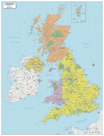
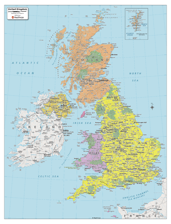
UK Political Map
Created specifically for MapSherpa, this United Kingdom Political Map shows all the countries and island that make up the UK. The map shows the Shetland Islands in the extreme north, all the way to the Channel Islands in the south. All major cities are noted, as well as National Parks and primary physical features such as mountain ranges, rivers, and lakes. Note, the Republic of Ireland, is not part of the UK, but is fully featured on this map. With multiple sizes available, this is the perfect reference map for home, office, or school use.
Page Size: 32 x 42 in (813 x 1067 mm)
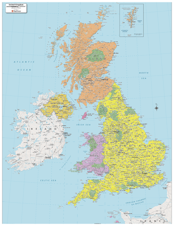
UK Political Map - Compact
Created specifically for MapSherpa, this United Kingdom Political Map shows all the countries and island that make up the UK. The map shows the Shetland Islands in the extreme north, all the way to the Channel Islands in the south. All major cities are noted, as well as National Parks and primary physical features such as mountain ranges, rivers, and lakes. Note, the Republic of Ireland, is not part of the UK, but is fully featured on this map. With multiple sizes available, this is the perfect reference map for home, office, or school use.
Page Size: 16 x 21 in (406 x 533 mm)
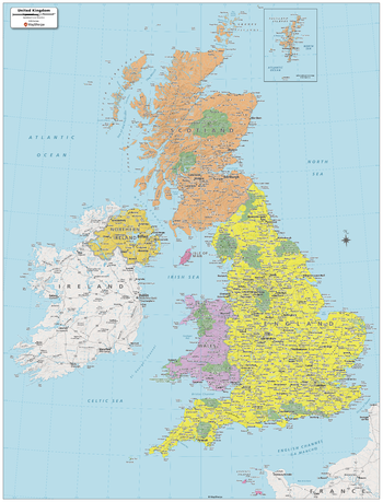
UK Political Map - Extra Large
Created specifically for MapSherpa, this United Kingdom Political Map shows all the countries and island that make up the UK. The map shows the Shetland Islands in the extreme north, all the way to the Channel Islands in the south. All major cities are noted, as well as National Parks and primary physical features such as mountain ranges, rivers, and lakes. Note, the Republic of Ireland, is not part of the UK, but is fully featured on this map. With multiple sizes available, this is the perfect reference map for home, office, or school use.
Page Size: 40 x 52 in (1016 x 1321 mm)
UK Political Map - Large
Created specifically for MapSherpa, this United Kingdom Political Map shows all the countries and island that make up the UK. The map shows the Shetland Islands in the extreme north, all the way to the Channel Islands in the south. All major cities are noted, as well as National Parks and primary physical features such as mountain ranges, rivers, and lakes. Note, the Republic of Ireland, is not part of the UK, but is fully featured on this map. With multiple sizes available, this is the perfect reference map for home, office, or school use.
Page Size: 24 x 31.5 in (610 x 800 mm)