


MapSherpa

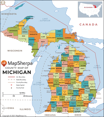
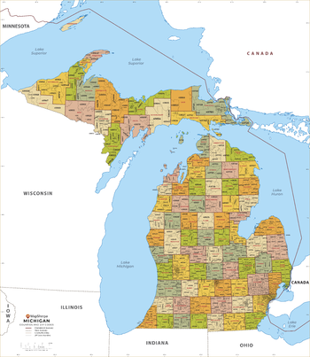
Michigan Counties Map - Extra Large
This map has been created exclusively for MapSherpa, and designed for reference or business use. Clear and clean colors & fonts matched with cartographic research makes this map of Michigan Counties Map easily readable and useful. The map shows the 83 counties of Michigan and their borders across the Wolverine State.
Page Size: 60 x 67.75 in (1524 x 1716 mm)
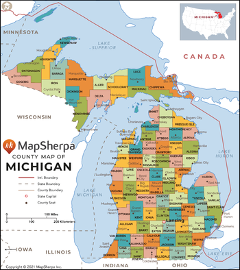
Michigan Counties Map - Large
This map has been created exclusively for MapSherpa, and designed for reference or business use. Clear and clean colors & fonts matched with cartographic research makes this map of Michigan Counties Map easily readable and useful. The map shows the 83 counties of Michigan and their borders across the Wolverine State.
Page Size: 48 x 54.25 in (1219 x 1372 mm)
Michigan Counties Map - Standard
This map has been created exclusively for MapSherpa, and designed for reference or business use. Clear and clean colors & fonts matched with cartographic research makes this map of Michigan Counties Map easily readable and useful. The map shows the 83 counties of Michigan and their borders across the Wolverine State.
Page Size: 36 x 40.75 in (914 x 1029 mm)
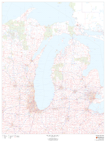
Michigan ZIP Code Map
This map of Michigan shows ZIP codes overlaid on a road map. Base map features include county boundaries, major road network features, and state and national parks and conservation areas.
Page Size: 36 x 48 in (914 x 1219 mm)

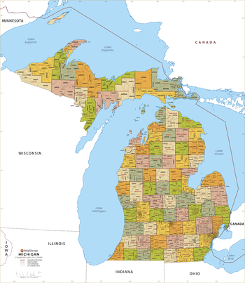
Michigan ZIP Code Map with Counties - Extra Large
This map has been created exclusively for MapSherpa, and designed for business or reference use. Clear and clean colors & fonts matched with cartographic research makes this Michigan Zip Code Map with Counties easily readable and useful. The map shows the 83 counties of Michigan and the borders of the 979 zip codes across the Wolverine State.
Page Size: 60 x 69.25 in (1524 x 1753 mm)
Michigan ZIP Code Map with Counties - Large
This map has been created exclusively for MapSherpa, and designed for business or reference use. Clear and clean colors & fonts matched with cartographic research makes this Michigan Zip Code Map with Counties easily readable and useful. The map shows the 83 counties of Michigan and the borders of the 979 zip codes across the Wolverine State.
Page Size: 48 x 55.25 in (1219 x 1403 mm)
Michigan ZIP Code Map with Counties - Standard
This map has been created exclusively for MapSherpa, and designed for business or reference use. Clear and clean colors & fonts matched with cartographic research makes this Michigan Zip Code Map with Counties easily readable and useful. The map shows the 83 counties of Michigan and the borders of the 979 zip codes across the Wolverine State.
Page Size: 36 x 41.5 in (914 x 1052 mm)
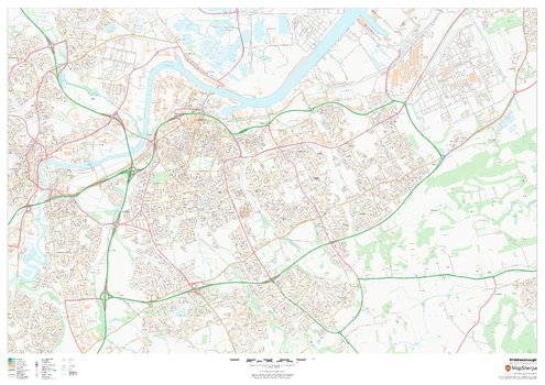
Middlesbrough
This map of Middlesbrough shows detailed street level information including extensive street labelling. Ideal for planning of deliveries, home services, sales territories, real estate and much more.
Page Size: 47 x 33.25 in (1189 x 841 mm)

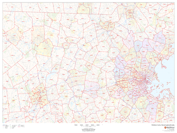
Middlesex County, Massachusetts
This map of Middlesex County, Massachusetts shows regional level information. Base map features include highways and major roads with labelling; railways; high level land use such as parks and recreation areas; and a selection of points of interest including transportation hubs like airports and train stations, tourist information and police stations. ZIP code boundaries are shown as a secondary map feature.
Page Size: 48 x 36 in (1219 x 914 mm)
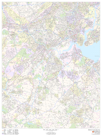
Middlesex County, Massachusetts ZIP Codes
This map of Middlesex County, Massachusetts shows ZIP code areas overlaid on a road map. Ideal for planning of deliveries, home services, sales territories, real estate and much more. Base map features include all roads with major roads and highways labelled; neighborhood names; railways; and high level land use such as parks and recreation areas, industrial areas and hospital campuses.
Page Size: 48 x 36 in (1219 x 914 mm)
Middlesex County, New Jersey
This map of Middlesex County, New Jersey shows street level information including street labeling. Base map features include all roads with major roads and highways labelled; neighborhood names; railways; high level land use such as parks and recreation areas, industrial areas and hospital campuses; and a variety of points of interest including libraries, stadiums, museums, border crossings and more. ZIP code boundaries are shown as a secondary map feature.
Page Size: 36 x 48 in (914 x 1219 mm)
Middlesex County, New Jersey ZIP Codes
This map of Middlesex County, New Jersey shows ZIP code areas overlaid on a road map. Ideal for planning of deliveries, home ervices, sales territories, real estate and much more. Base map features include all roads with major roads and highways labelled; neighborhood names; railways; and high level land use such as parks and recreation areas, industrial areas and hospital campuses.
Page Size: 36 x 48 in (914 x 1219 mm)
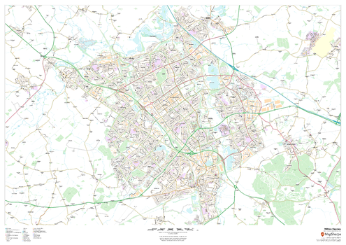
Milton Keynes
This map of Milton Keynes shows detailed street level information including extensive street labelling. Ideal for planning of deliveries, home services, sales territories, real estate and much more.
Page Size: 47 x 33.25 in (1189 x 841 mm)
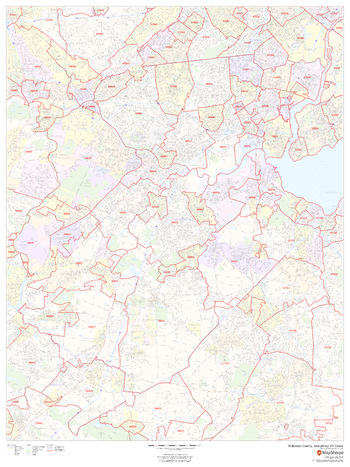
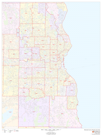
Milwaukee County, Wisconsin
This map of Milwaukee County, Wisconsin shows street level information including street labeling. Base map features include all roads with major roads and highways labelled; neighborhood names; railways; high level land use such as parks and recreation areas, industrial areas and hospital campuses; and a variety of points of interest including libraries, stadiums, museums, border crossings and more. ZIP code boundaries are shown as a secondary map feature.
Page Size: 36 x 48 in (914 x 1219 mm)
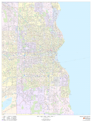
Milwaukee County, Wisconsin ZIP Codes
This map of Milwaukee County, Wisconsin shows ZIP code areas overlaid on a road map. Ideal for planning of deliveries, home services, sales territories, real estate and much more. Base map features include all roads with major roads and highways labelled; neighborhood names; railways; and high level land use such as parks and recreation areas, industrial areas and hospital campuses.
Page Size: 36 x 48 in (914 x 1219 mm)
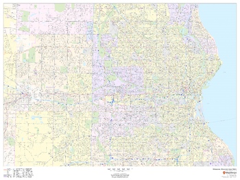
Milwaukee, Wisconsin Inner Metro - Landscape
This landscape-oriented map of central Milwaukee, Wisconsin shows detailed street level information including extensive street labeling. Ideal for planning of deliveries, home services, sales territories, real estate and much more. Base map features include all roads with major roads and highways labelled; neighborhood names; railways; high level land use such as parks and recreation areas, industrial areas and hospital campuses; and a variety of points of interest including schools, libraries, stadiums, museums, border crossings and more.
Page Size: 48 x 36 in (1219 x 914 mm)
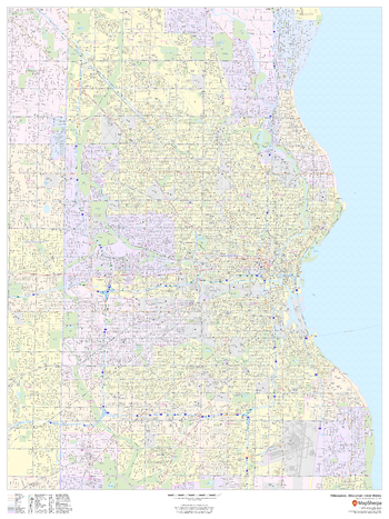
Milwaukee, Wisconsin Inner Metro - Portrait
This portrait-oriented map of central Milwaukee, Wisconsin shows detailed street level information including extensive street labeling. Ideal for planning of deliveries, home services, sales territories, real estate and much more. Base map features include all roads with major roads and highways labelled; neighborhood names; railways; high level land use such as parks and recreation areas, industrial areas and hospital campuses; and a variety of points of interest including schools, libraries, stadiums, museums, border crossings and more.
Page Size: 36 x 48 in (914 x 1219 mm)
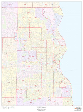
Milwaukee, Wisconsin ZIP Codes
This map of Milwaukee, Wisconsin shows ZIP code areas overlaid on a road map. Ideal for planning of deliveries, home services, sales territories, real estate and much more. Base map features include all roads with major roads and highways labelled; neighborhood names; railways; and high level land use such as parks and recreation areas, industrial areas and hospital campuses.
Page Size: 36 x 48 in (914 x 1219 mm)
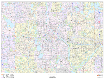
Minneapolis, Minnesota - Landscape
This landscape-oriented map of Minneapolis, Minnesota shows detailed street level information including extensive street labeling. Ideal for planning of deliveries, home services, sales territories, real estate and much more. Base map features include all roads with major roads and highways labelled; neighborhood names; railways; high level land use such as parks and recreation areas, industrial areas and hospital campuses; and a variety of points of interest including schools, libraries, stadiums, museums, border crossings and more.
Page Size: 48 x 36 in (1219 x 914 mm)
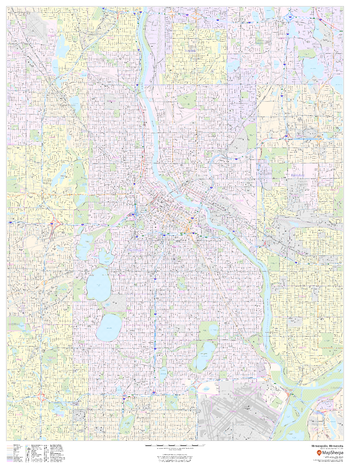
Minneapolis, Minnesota - Portrait
This portrait-oriented map of Minneapolis, Minnesota shows detailed street level information including extensive street labeling. Ideal for planning of deliveries, home services, sales territories, real estate and much more. Base map features include all roads with major roads and highways labelled; neighborhood names; railways; high level land use such as parks and recreation areas, industrial areas and hospital campuses; and a variety of points of interest including schools, libraries, stadiums, museums, border crossings and more.
Page Size: 36 x 48 in (914 x 1219 mm)