


MapSherpa
MasterMap Colour 1:2500
The most detailed and comprehensive map data-set of Great Britain from the Ordnance Survey. Mapping data is updated quarterly so maps are always current. Maps are suitable for Planning applications and Land Registry purposes. Maps can be created in colour at a fixed scale of 1:2,500.
MasterMap Colour 1:2500 Flex
The most detailed and comprehensive map data-set of Great Britain from the Ordnance Survey. Mapping data is updated quarterly so maps are always current. Maps are suitable for Planning applications and Land Registry purposes. Maps can be created in colour at a flexible scale between 1:1,000 and 1:2,500.
MasterMap Colour 1:500
The most detailed and comprehensive map data-set of Great Britain from the Ordnance Survey. Mapping data is updated quarterly so maps are always current. Maps are suitable for Planning applications and Land Registry purposes. Maps can be created in colour at a fixed scale of 1:500.
MasterMap Colour 1:500 Flex
The most detailed and comprehensive map data-set of Great Britain from the Ordnance Survey. Mapping data is updated quarterly so maps are always current. Maps are suitable for Planning applications and Land Registry purposes. Maps can be created in colour at a flexible scale between 1:160 and 1:500.
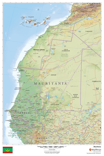
Mauritania
This beautiful map shows physical and political features for Mauritania and surrounding areas. Relief shading and the use of different colours by height above sea level are both informative and attractive.
Page Size: 24 x 36 in (610 x 914 mm)
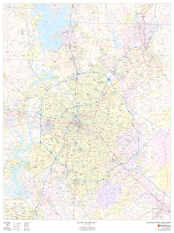
Mecklenburg County, North Carolina
This map of Mecklenburg County, North Carolina shows regional level information. Base map features include highways and major roads with labelling; neighborhood names; railways; high level land use such as parks and recreation areas, industrial areas and hospital campuses; and a selection of points of interest including transportation hubs like airports and train stations, tourist information, police stations and shopping centres. ZIP code boundaries are shown as a secondary map feature.
Page Size: 36 x 48 in (914 x 1219 mm)
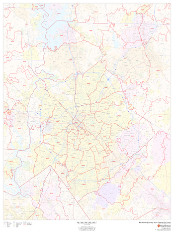
Mecklenburg County, North Carolina ZIP Codes
This map of Mecklenburg County, North Carolina shows ZIP code areas overlaid on a road map. Ideal for planning of deliveries, home services, sales territories, real estate and much more. Base map features include all roads with major roads and highways labelled; neighborhood names; railways; and high level land use such as parks and recreation areas, industrial areas and hospital campuses.
Page Size: 36 x 48 in (914 x 1219 mm)
Memphis, Tennessee Inner Metro - Landscape
This landscape-oriented map of central Memphis, Tennessee shows detailed street level information including extensive street labeling. Ideal for planning of deliveries, home services, sales territories, real estate and much more. Base map features include all roads with major roads and highways labelled; neighborhood names; railways; high level land use such as parks and recreation areas, industrial areas and hospital campuses; and a variety of points of interest including schools, libraries, stadiums, museums, border crossings and more.
Page Size: 48 x 36 in (1219 x 914 mm)

Memphis, Tennessee Inner Metro - Portrait
This portrait-oriented map of central Memphis, Tennessee shows detailed street level information including extensive street labeling. Ideal for planning of deliveries, home services, sales territories, real estate and much more. Base map features include all roads with major roads and highways labelled; neighborhood names; railways; high level land use such as parks and recreation areas, industrial areas and hospital campuses; and a variety of points of interest including schools, libraries, stadiums, museums, border crossings and more.
Page Size: 36 x 48 in (914 x 1219 mm)
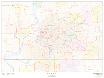
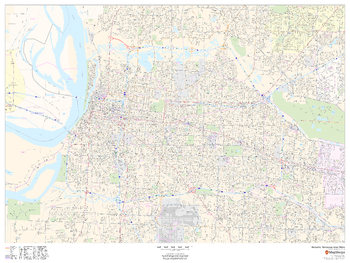
Memphis, Tennessee ZIP Codes
This map of Memphis shows ZIP code areas overlaid on a road map. Ideal for planning of deliveries, home services, sales territories, real estate and much more. Base map features include all roads with major roads and highways labelled; neighborhood names; railways; and high level land use such as parks and recreation areas, industrial areas and hospital campuses.
Page Size: 48 x 36 in (1219 x 914 mm)
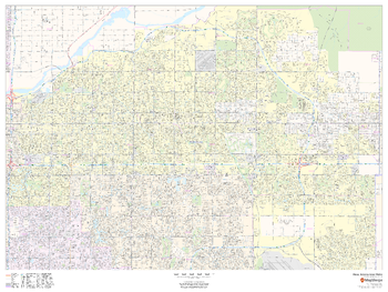
Mesa, Arizona Inner Metro - Landscape
This landscape-oriented map of central Mesa, Arizona shows detailed street level information including extensive street labeling. Ideal for planning of deliveries, home services, sales territories, real estate and much more. Base map features include all roads with major roads and highways labelled; neighborhood names; railways; high level land use such as parks and recreation areas, industrial areas and hospital campuses; and a variety of points of interest including schools, libraries, stadiums, museums, border crossings and more.
Page Size: 48 x 36 in (1219 x 914 mm)
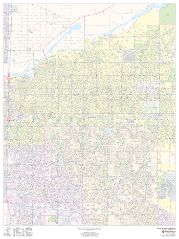
Mesa, Arizona Inner Metro - Portrait
This portrait-oriented map of central Mesa, Arizona shows detailed street level information including extensive street labeling. Ideal for planning of deliveries, home services, sales territories, real estate and much more. Base map features include all roads with major roads and highways labelled; neighborhood names; railways; high level land use such as parks and recreation areas, industrial areas and hospital campuses; and a variety of points of interest including schools, libraries, stadiums, museums, border crossings and more.
Page Size: 36 x 48 in (914 x 1219 mm)
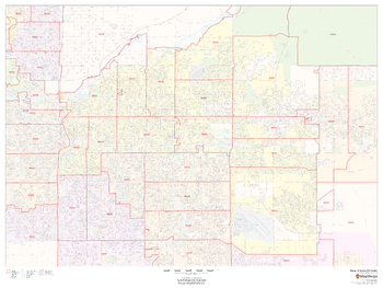
Mesa, Arizona ZIP Codes
This map of Mesa, Arizona shows ZIP code areas overlaid on a road map. Ideal for planning of deliveries, home services, sales territories, real estate and much more. Base map features include all roads with major roads and highways labelled; neighborhood names; railways; and high level land use such as parks and recreation areas, industrial areas and hospital campuses.
Page Size: 48 x 36 in (1219 x 914 mm)
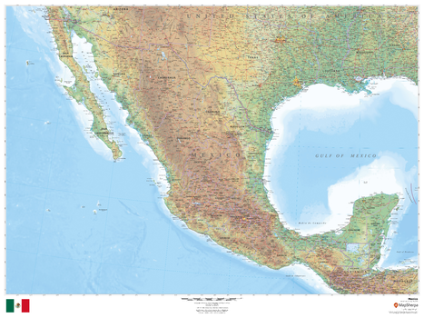
Mexico
This beautiful map shows physical and political features for Mexico and surrounding areas. Relief shading and the use of different colours by height above sea level are both informative and attractive.
Page Size: 48 x 36 in (1219 x 914 mm)
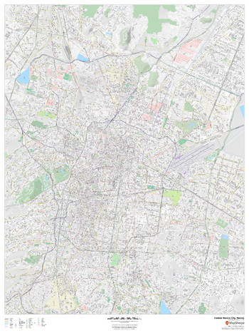
Mexico City, Mexico Inner Metro
This detailed street map of central Mexico City, Mexico shows the full road and rail networks, points of interest, and land use across the city. Useful for businesses operating in the city, or as consumer memorabilia of the city.
Page Size: 36 x 48 in (914 x 1219 mm)
Miami, Florida - Landscape
This landscape-oriented map of Miami, Florida shows detailed street level information including extensive street labeling. Ideal for planning of deliveries, home services, sales territories, real estate and much more. Base map features include all roads with major roads and highways labelled; neighborhood names; railways; high level land use such as parks and recreation areas, industrial areas and hospital campuses; and a variety of points of interest including schools, libraries, stadiums, museums, border crossings and more.
Page Size: 48 x 36 in (1219 x 914 mm)
Miami, Florida - Portrait
This portrait-oriented map of Miami, Florida shows detailed street level information including extensive street labeling. Ideal for planning of deliveries, home services, sales territories, real estate and much more. Base map features include all roads with major roads and highways labelled; neighborhood names; railways; high level land use such as parks and recreation areas, industrial areas and hospital campuses; and a variety of points of interest including schools, libraries, stadiums, museums, border crossings and more.
Page Size: 36 x 48 in (914 x 1219 mm)
Miami, Florida ZIP Codes
This map of Miami, Florida shows ZIP code areas overlaid on a road map. Ideal for planning of deliveries, home services, sales territories, real estate and much more. Base map features include all roads with major roads and highways labelled; neighborhood names; railways; and high level land use such as parks and recreation areas, industrial areas and hospital campuses.
Page Size: 48 x 36 in (1219 x 914 mm)
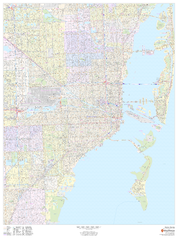
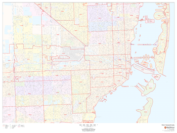
Miami-Dade County, Florida
This map of Miami-Dade County, Florida shows regional level information. Base map features include highways and major roads with labelling; railways; high level land use such as parks and recreation areas; and a selection of points of interest including transportation hubs like airports and train stations, tourist information and police stations. ZIP code boundaries are shown as a secondary map feature.
Page Size: 36 x 48 in (914 x 1219 mm)
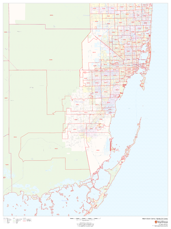
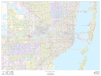
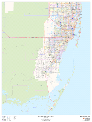
Miami-Dade County, Florida ZIP Codes
This map of Miami-Dade County, Florida shows ZIP code areas overlaid on a road map. Ideal for planning of deliveries, home services, sales territories, real estate and much more. Base map features include all roads with major roads and highways labelled; neighborhood names; railways; and high level land use such as parks and recreation areas, industrial areas and hospital campuses.
Page Size: 36 x 48 in (914 x 1219 mm)