MapSherpa
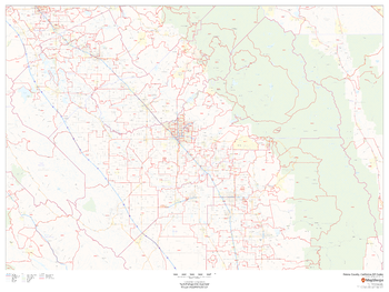
Fresno County, California ZIP Codes
This map of Fresno County, California shows ZIP code areas overlaid on a road map. Ideal for planning of deliveries, home services, sales territories, real estate and much more. Base map features include all roads with major roads and highways labelled; neighborhood names; railways; and high level land use such as parks and recreation areas, industrial areas and hospital campuses.
Page Size: 48 x 36 in (1219 x 914 mm)
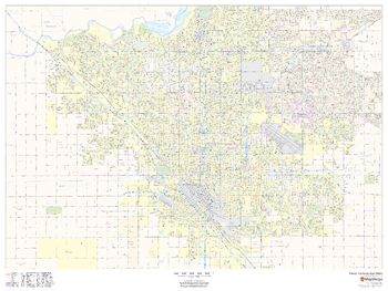
Fresno, California Inner Metro - Landscape
This landscape-oriented map of central Fresno, California shows detailed street level information including extensive street labeling. Ideal for planning of deliveries, home services, sales territories, real estate and much more. Base map features include all roads with major roads and highways labelled; neighborhood names; railways; high level land use such as parks and recreation areas, industrial areas and hospital campuses; and a variety of points of interest including schools, libraries, stadiums, museums, border crossings and more.
Page Size: 48 x 36 in (1219 x 914 mm)
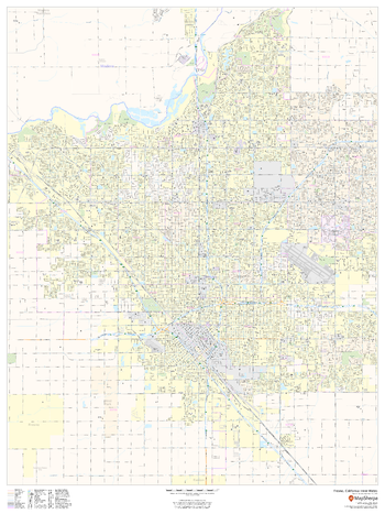
Fresno, California Inner Metro - Portrait
This portrait-oriented map of central Fresno, California shows detailed street level information including extensive street labeling. Ideal for planning of deliveries, home services, sales territories, real estate and much more. Base map features include all roads with major roads and highways labelled; neighborhood names; railways; high level land use such as parks and recreation areas, industrial areas and hospital campuses; and a variety of points of interest including schools, libraries, stadiums, museums, border crossings and more.
Page Size: 36 x 48 in (914 x 1219 mm)
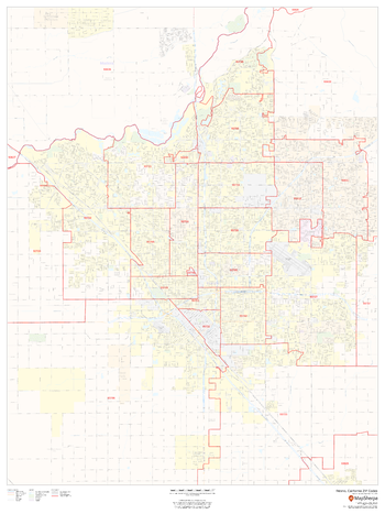
Fresno, California ZIP Codes
This map of Fresno, California shows ZIP code areas overlaid on a road map. Ideal for planning of deliveries, home services, sales territories, real estate and much more. Base map features include all roads with major roads and highways labelled; neighborhood names; railways; and high level land use such as parks and recreation areas, industrial areas and hospital campuses.
Page Size: 36 x 48 in (914 x 1219 mm)
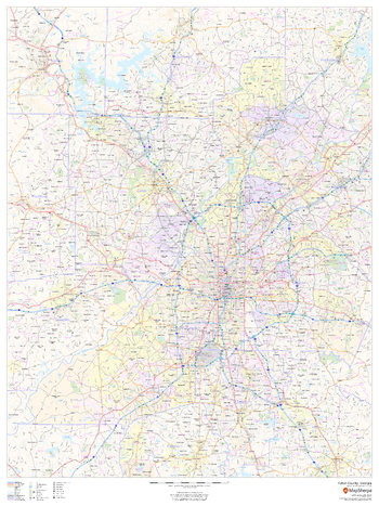
Fulton County, Georgia
This map of Fulton County, Georgia shows regional level information. Base map features include highways and major roads with labelling; railways; high level land use such as parks and recreation areas; and a selection of points of interest including transportation hubs like airports and train stations, tourist information and police stations. ZIP code boundaries are shown as a secondary map feature.
Page Size: 36 x 48 in (914 x 1219 mm)
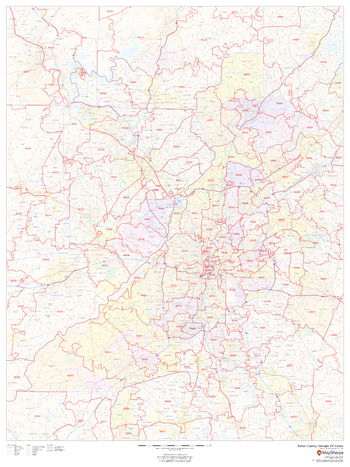
Fulton County, Georgia ZIP Codes
This map of Fulton County, Georgia shows ZIP code areas overlaid on a road map. Ideal for planning of deliveries, home services, sales territories, real estate and much more. Base map features include all roads with major roads and highways labelled; neighborhood names; railways; and high level land use such as parks and recreation areas, industrial areas and hospital campuses.
Page Size: 36 x 48 in (914 x 1219 mm)
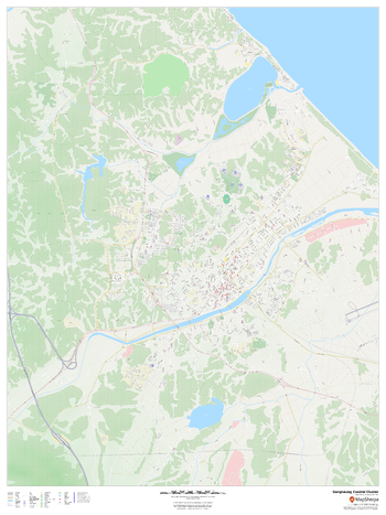
Gangneung 2018 Winter Games Coastal Cluster Venues
This street map of Gangneung highlights the 6 venues of the 2018 PyeongChang winter games that are in the Gangneung Coastal Cluster: Kwandong Hockey Centre, Gangneung Curling Centre, Gangneung Hockey Centre, Gangneung Ice Arena, Gangneung Oval, and Gangneung Olympic Park.
Page Size: 36 x 48 in (914 x 1219 mm)

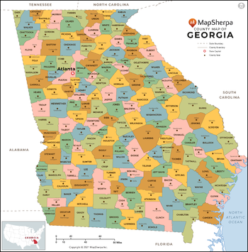
Georgia Counties Map - Extra Large
This map has been created exclusively for MapSherpa, and designed for reference or business use. Clear and clean colors & fonts matched with cartographic research makes this map of Georgia Counties Map easily readable and useful. The map shows the 159 counties of Georgia and their borders across the Peach State.
Page Size: 60 x 61 in (1524 x 1544 mm)

Georgia Counties Map - Large
This map has been created exclusively for MapSherpa, and designed for reference or business use. Clear and clean colors & fonts matched with cartographic research makes this map of Georgia Counties Map easily readable and useful. The map shows the 159 counties of Georgia and their borders across the Peach State.
Page Size: 48 x 48.75 in (1219 x 1235 mm)
Georgia Counties Map - Standard
This map has been created exclusively for MapSherpa, and designed for reference or business use. Clear and clean colors & fonts matched with cartographic research makes this map of Georgia Counties Map easily readable and useful. The map shows the 159 counties of Georgia and their borders across the Peach State.
Page Size: 36 x 36.5 in (914 x 926 mm)
Georgia State Wall Map - Compact
This detailed wall map of Georgia is perfect for both educational and business purposes. The easy-to-read map features vibrant colors and clear labeling of cities, counties, highways, and geographical features. All national and state highways that connect the state are all clearly labelled on the map, while the legend notes the different road and land use classifications such as urban, park, military, and many more. The boundaries of each county in the state are defined and named clearly. Whether you are a student, teacher, business person or geography enthusiast, this map is a valuable addition to any space.
Page Size: 16 x 20 in (406 x 508 mm)
Georgia State Wall Map - Extra Large
This detailed wall map of Georgia is perfect for both educational and business purposes. The easy-to-read map features vibrant colors and clear labeling of cities, counties, highways, and geographical features. All national and state highways that connect the state are all clearly labelled on the map, while the legend notes the different road and land use classifications such as urban, park, military, and many more. The boundaries of each county in the state are defined and named clearly. Whether you are a student, teacher, business person or geography enthusiast, this map is a valuable addition to any space.
Page Size: 40 x 60 in (1016 x 1524 mm)
Georgia State Wall Map - Large
This detailed wall map of Georgia is perfect for both educational and business purposes. The easy-to-read map features vibrant colors and clear labeling of cities, counties, highways, and geographical features. All national and state highways that connect the state are all clearly labelled on the map, while the legend notes the different road and land use classifications such as urban, park, military, and many more. The boundaries of each county in the state are defined and named clearly. Whether you are a student, teacher, business person or geography enthusiast, this map is a valuable addition to any space.
Page Size: 32 x 48 in (813 x 1219 mm)
Georgia State Wall Map - Poster
This detailed wall map of Georgia is perfect for both educational and business purposes. The easy-to-read map features vibrant colors and clear labeling of cities, counties, highways, and geographical features. All national and state highways that connect the state are all clearly labelled on the map, while the legend notes the different road and land use classifications such as urban, park, military, and many more. The boundaries of each county in the state are defined and named clearly. Whether you are a student, teacher, business person or geography enthusiast, this map is a valuable addition to any space.
Page Size: 24 x 30 in (610 x 762 mm)
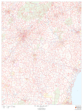
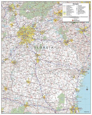
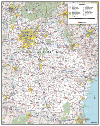
Georgia ZIP Code Map
This map of Georgia shows ZIP codes overlaid on a road map. Base map features include municipality and county boundaries, major road network features, and state and national parks and conservation areas.
Page Size: 36 x 48 in (914 x 1219 mm)
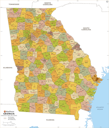
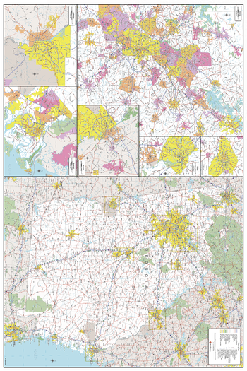
Georgia ZIP Code Map with Counties - Extra Large
This map has been created exclusively for MapSherpa, and designed for business or reference use. Clear and clean colors & fonts matched with cartographic research makes this Georgia Zip Code Map with Counties easily readable and useful. The map shows the 159 counties of Georgia and the borders of the over 700 zip codes across the Peach State.
Page Size: 60 x 70.5 in (1524 x 1789 mm)
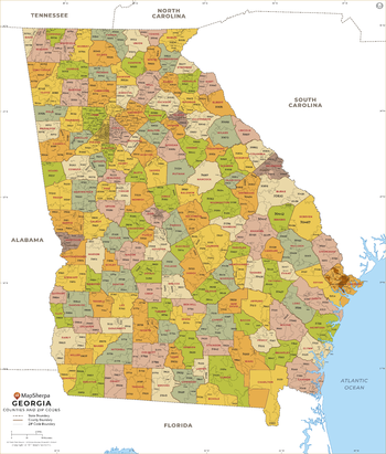
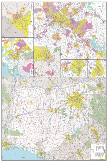
Georgia ZIP Code Map with Counties - Large
This map has been created exclusively for MapSherpa, and designed for business or reference use. Clear and clean colors & fonts matched with cartographic research makes this Georgia Zip Code Map with Counties easily readable and useful. The map shows the 159 counties of Georgia and the borders of the over 700 zip codes across the Peach State.
Page Size: 48 x 56.5 in (1219 x 1431 mm)

Georgia ZIP Code Map with Counties - Standard
This map has been created exclusively for MapSherpa, and designed for business or reference use. Clear and clean colors & fonts matched with cartographic research makes this Georgia Zip Code Map with Counties easily readable and useful. The map shows the 159 counties of Georgia and the borders of the over 700 zip codes across the Peach State.
Page Size: 36 x 42.25 in (914 x 1073 mm)
Germany Streets
Multi-scale product for Germany based on OpenStreetMap content. Appropriate for street, city and regional level mapping starting from 1:10,000 and up.
Gibraltar
This map of Gibraltar features a full detailed road network for the island, walking paths, land use, points of interest, and almost all buildings. Useful for the traveller, and as a wall map for display in your home.
Page Size: 33.25 x 47 in (841 x 1189 mm)