MapSherpa
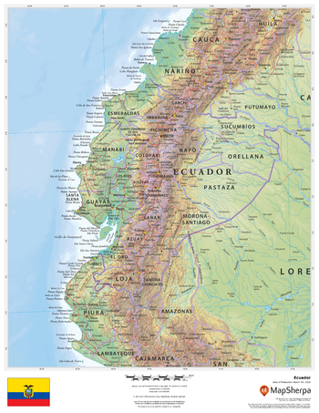
Ecuador
This beautiful map shows physical and political features for Ecuador and surrounding areas. Relief shading and the use of different colours by height above sea level are both informative and attractive.
Page Size: 17 x 22 in (432 x 559 mm)
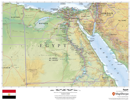
Egypt
This beautiful map shows physical and political features for Egypt and surrounding areas. Relief shading and the use of different colours by height above sea level are both informative and attractive.
Page Size: 22 x 17 in (559 x 432 mm)
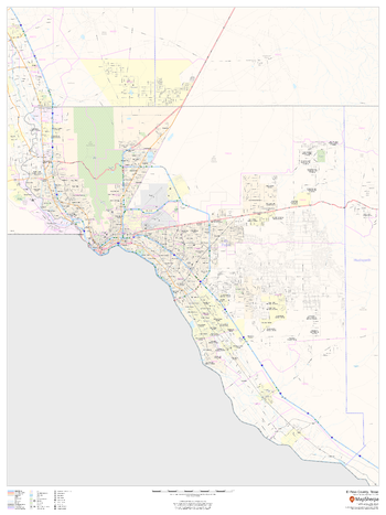
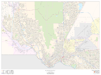
El Paso County, Texas
This map of El Paso County, Texas shows regional level information. Base map features include highways and major roads with labelling; neighborhood names; railways; high level land use such as parks and recreation areas, industrial areas and hospital campuses; and a selection of points of interest including transportation hubs like airports and train stations, tourist information, police stations and shopping centres. ZIP code boundaries are shown as a secondary map feature.
Page Size: 36 x 48 in (914 x 1219 mm)
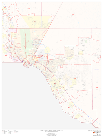
El Paso County, Texas ZIP Codes
This map of El Paso County, Texas shows ZIP code areas overlaid on a road map. Ideal for planning of deliveries, home ervices, sales territories, real estate and much more. Base map features include all roads with major roads and highways labelled; neighborhood names; railways; and high level land use such as parks and recreation areas, industrial areas and hospital campuses.
Page Size: 36 x 48 in (914 x 1219 mm)
El Paso, Texas Inner Metro - Landscape
This landscape-oriented map of central El Paso, Texas shows detailed street level information including extensive street labeling. Ideal for planning of deliveries, home services, sales territories, real estate and much more. Base map features include all roads with major roads and highways labelled; neighborhood names; railways; high level land use such as parks and recreation areas, industrial areas and hospital campuses; and a variety of points of interest including schools, libraries, stadiums, museums, border crossings and more.
Page Size: 48 x 36 in (1219 x 914 mm)
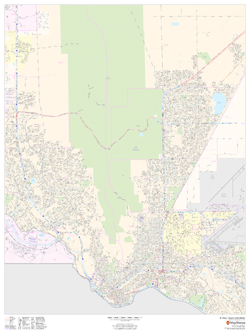
El Paso, Texas Inner Metro - Portrait
This portrait-oriented map of central El Paso, Texas shows detailed street level information including extensive street labeling. Ideal for planning of deliveries, home services, sales territories, real estate and much more. Base map features include all roads with major roads and highways labelled; neighborhood names; railways; high level land use such as parks and recreation areas, industrial areas and hospital campuses; and a variety of points of interest including schools, libraries, stadiums, museums, border crossings and more.
Page Size: 36 x 48 in (914 x 1219 mm)
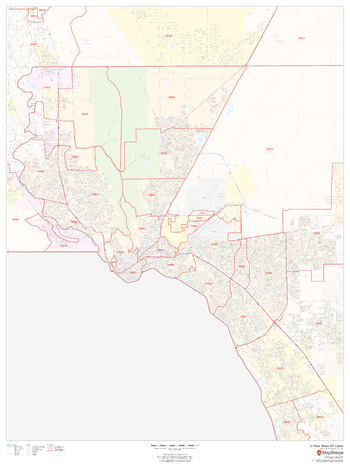
El Paso, Texas ZIP Codes
This map of El Paso shows ZIP code areas overlaid on a road map. Ideal for planning of deliveries, home services, sales territories, real estate and much more. Base map features include all roads with major roads and highways labelled; neighborhood names; railways; and high level land use such as parks and recreation areas, industrial areas and hospital campuses.
Page Size: 36 x 48 in (914 x 1219 mm)
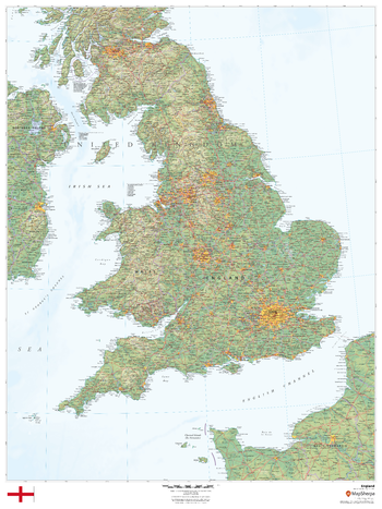
England
This beautiful map shows physical and political features for England and surrounding areas. Relief shading and the use of different colours by height above sea level are both informative and attractive.
Page Size: 36 x 48 in (914 x 1219 mm)
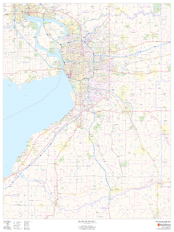
Erie County, New York
This map of Erie County, New York shows regional level information. Base map features include highways and major roads with labelling; neighborhood names; railways; high level land use such as parks and recreation areas, industrial areas and hospital campuses; and a selection of points of interest including transportation hubs like airports and train stations, tourist information, police stations and shopping centres. ZIP code boundaries are shown as a secondary map feature.
Page Size: 36 x 48 in (914 x 1219 mm)
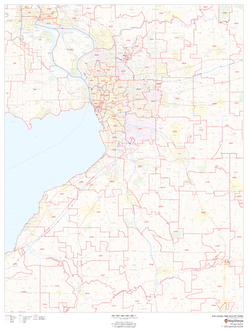
Erie County, New York ZIP Codes
This map of Erie County, New York shows ZIP code areas overlaid on a road map. Ideal for planning of deliveries, home ervices, sales territories, real estate and much more. Base map features include all roads with major roads and highways labelled; neighborhood names; railways; and high level land use such as parks and recreation areas, industrial areas and hospital campuses.
Page Size: 36 x 48 in (914 x 1219 mm)
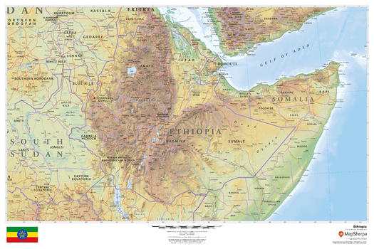
Ethiopia
This beautiful map shows physical and political features for Ethiopia and surrounding areas. Relief shading and the use of different colours by height above sea level are both informative and attractive.
Page Size: 36 x 24 in (914 x 610 mm)
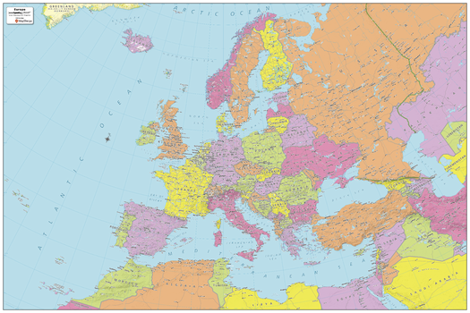
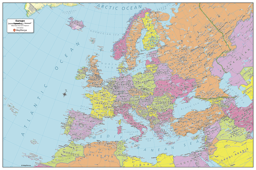
Europe Political Map
Explore the continent of Europe with this map created specifically for MapSherpa. New and up-to-date, this Map shows all the countries that make up the continent. Stretching from the Atlantic Ocean in the west to Arctic Circle and beyond, to the Ural Mountains and the Mediterranean Sea, this map prominently shows; national capitals, primary cities & towns, primary water features, mountain ranges and all time zones. With this map you can clearly see that some countries straddle both Europe and Asia! With multiple sizes available, this is the perfect reference map for home, office, or school use.
Page Size: 36 x 24 in (914 x 610 mm)
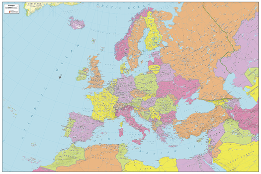
Europe Political Map - Compact
Explore the continent of Europe with this map created specifically for MapSherpa. New and up-to-date, this Map shows all the countries that make up the continent. Stretching from the Atlantic Ocean in the west to Arctic Circle and beyond, to the Ural Mountains and the Mediterranean Sea, this map prominently shows; national capitals, primary cities & towns, primary water features, mountain ranges and all time zones. With this map you can clearly see that some countries straddle both Europe and Asia! With multiple sizes available, this is the perfect reference map for home, office, or school use.
Page Size: 24.25 x 16.25 in (610 x 407 mm)
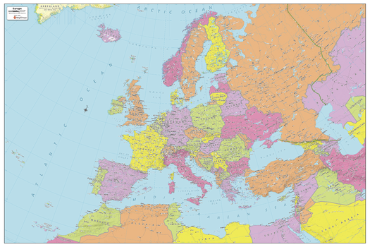
Europe Political Map - Extra Large
Explore the continent of Europe with this map created specifically for MapSherpa. New and up-to-date, this Map shows all the countries that make up the continent. Stretching from the Atlantic Ocean in the west to Arctic Circle and beyond, to the Ural Mountains and the Mediterranean Sea, this map prominently shows; national capitals, primary cities & towns, primary water features, mountain ranges and all time zones. With this map you can clearly see that some countries straddle both Europe and Asia! With multiple sizes available, this is the perfect reference map for home, office, or school use.
Page Size: 60 x 40 in (1524 x 1016 mm)
Europe Political Map - Large
Explore the continent of Europe with this map created specifically for MapSherpa. New and up-to-date, this Map shows all the countries that make up the continent. Stretching from the Atlantic Ocean in the west to Arctic Circle and beyond, to the Ural Mountains and the Mediterranean Sea, this map prominently shows; national capitals, primary cities & towns, primary water features, mountain ranges and all time zones. With this map you can clearly see that some countries straddle both Europe and Asia! With multiple sizes available, this is the perfect reference map for home, office, or school use.
Page Size: 48 x 32 in (1219 x 813 mm)
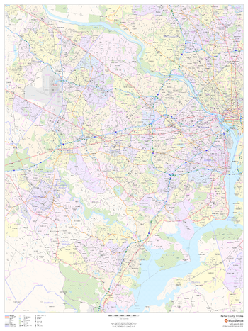
Fairfax County, Virginia
This map of Fairfax County, Virginia shows regional level information. Base map features include highways and major roads with labelling; neighborhood names; railways; high level land use such as parks and recreation areas, industrial areas and hospital campuses; and a selection of points of interest including transportation hubs like airports and train stations, tourist information, police stations and shopping centres. ZIP code boundaries are shown as a secondary map feature.
Page Size: 36 x 48 in (914 x 1219 mm)
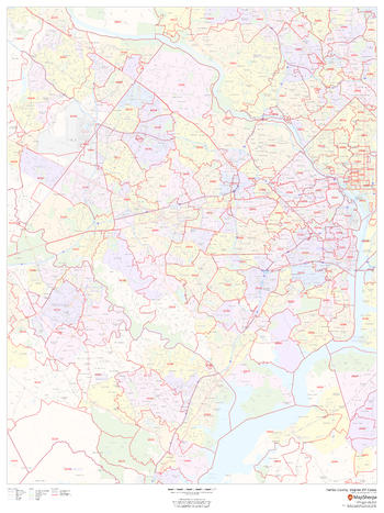
Fairfax County, Virginia ZIP Codes
This map of Fairfax County, Virginia shows ZIP code areas overlaid on a road map. Ideal for planning of deliveries, home services, sales territories, real estate and much more. Base map features include all roads with major roads and highways labelled; neighborhood names; railways; and high level land use such as parks and recreation areas, industrial areas and hospital campuses.
Page Size: 36 x 48 in (914 x 1219 mm)
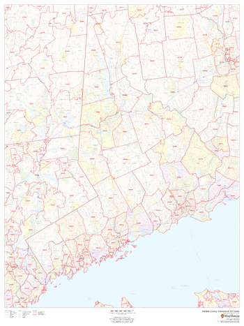
Fairfield County, Connecticut
This map of Fairfield County, Connecticut shows regional level information. Base map features include highways and major roads with labelling; neighborhood names; railways; high level land use such as parks and recreation areas, industrial areas and hospital campuses; and a selection of points of interest including transportation hubs like airports and train stations, tourist information, police stations and shopping centres. ZIP code boundaries are shown as a secondary map feature.
Page Size: 36 x 48 in (914 x 1219 mm)
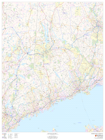
Fairfield County, Connecticut ZIP Codes
This map of Fairfield County, Connecticut shows ZIP code areas overlaid on a road map. Ideal for planning of deliveries, home ervices, sales territories, real estate and much more. Base map features include all roads with major roads and highways labelled; neighborhood names; railways; and high level land use such as parks and recreation areas, industrial areas and hospital campuses.
Page Size: 36 x 48 in (914 x 1219 mm)
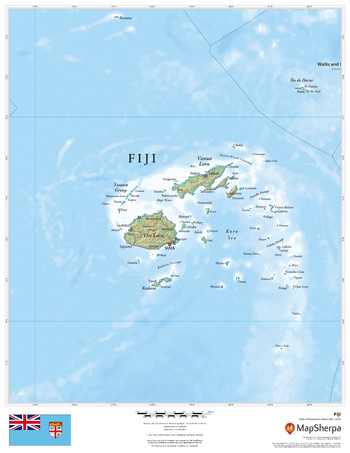
Fiji
This beautiful map shows physical and political features for Fiji. Relief shading and the use of different colours by height above sea level are both informative and attractive.
Page Size: 17 x 22 in (432 x 559 mm)