Lucidmap

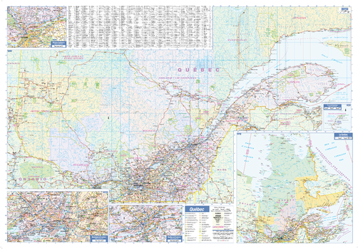
Quebec Province Wall Map - South Portion with North Inset
This bilingual wall map has been designed to show details of the populated areas of Quebec including all highways, cities and towns, major parks, political boundaries, and points of interest.
The map has been designed with a traditional Canadian style embraced by map buyers over many years.
All text is in both French and English.
Page Size: 40 x 28 in (1016 x 711 mm)
Quebec Province Wall Map - South Portion with North Inset - Large
This large bilingual wall map has been designed to show details of the populated areas of Quebec including all highways, cities and towns, major parks, political boundaries, and points of interest.
The map has been designed with a traditional Canadian style embraced by map buyers over many years.
All text is in both French and English.
Page Size: 54 x 37.5 in (1372 x 953 mm)
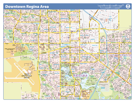
Regina Downtown - Compact
Map of downtown Regina showing all roads, road names, political boundaries, transit, points of interest, parks, schools, churches, public buildings and landmarks.
Page Size: 21.5 x 16.25 in (546 x 413 mm)
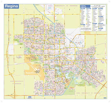
Regina Wall Map - Street Detail
This wall map shows highly detailed local information for the city of Regina. Full street labeling along with transit information, parks, schools, churches and landmarks throughout the city are displayed.
The map has been designed in a very clear and legible manner with a traditional Canadian street map style embraced by map buyers over many years.
Page Size: 27 x 25 in (686 x 635 mm)
Rockies-Okanagan
Create custom regional maps in Canada from this series of attractive detailed road maps covering most of the populated areas across Canada. Maps are developed from Lucidmap’s iconic Canadian cartography. Coverage area ranges from Calgary, AB to Penticton, BC east-west, and from the Canada-USA border to Valleyview, AB north-south. The BC-Alberta border and the parks along it are the central features of the map. Native scale is 1:500,000.

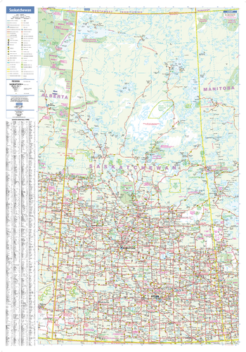
Saskatchewan Wall Map
This wall map has been designed to show important features in Saskatchewan including all highways, cities and towns, major parks, political boundaries, and points of interest.
The map has been designed with a traditional Canadian style embraced by map buyers over many years.
Page Size: 28 x 40 in (711 x 1016 mm)
Saskatchewan Wall Map - Large
This large wall map has been designed to show important features in Saskatchewan including all highways, cities and towns, major parks, political boundaries, and points of interest.
The map has been designed with a traditional Canadian style embraced by map buyers over many years.
Page Size: 37.5 x 54 in (953 x 1372 mm)
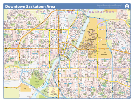
Saskatoon Downtown - Compact
Map of downtown Saskatoon showing all roads, road names, political boundaries, transit, points of interest, parks, schools, churches, public buildings and landmarks.
Page Size: 21.5 x 16.25 in (546 x 413 mm)
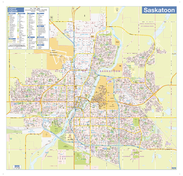
Saskatoon Wall Map - Street Detail
This wall map shows highly detailed local information for the city of Saskatoon. Full street labeling along with transit information, parks, schools, churches and landmarks throughout the city are displayed.
The map has been designed in a very clear and legible manner with a traditional Canadian street map style embraced by map buyers over many years.
Page Size: 28 x 27 in (711 x 686 mm)
Southern Alberta and Saskatchewan
Create custom regional maps in Canada from this series of attractive detailed road maps covering most of the populated areas across Canada. Maps are developed from Lucidmap’s iconic Canadian cartography. Coverage area starts at the Canada-USA border in the south, and ranges north to Lac La Biche. East-west coverage spans from North Battleford, SK to Red Deer, AB. Native scale is 1:500,000.
Southern British Columbia
Create custom regional maps in Canada from this series of attractive detailed road maps covering most of the populated areas across Canada. Maps are developed from Lucidmap’s iconic Canadian cartography. Coverage includes all of Vancouver Island, and up the mainland coast from Vancouver to Queen Charlotte Sound. Communities along the eastern map limit include Kamloops and Clearwater. The northern limit of the map contains areas north of Prince George, including Bear Lake. Coverage follows the Yellowhead highway west from Pringe George to Vanderhoof, Fraser Lake and Savory. Native scale is 1:500,000.
Southern Manitoba
Create custom regional maps in Canada from this series of attractive detailed road maps covering most of the populated areas across Canada. Maps are developed from Lucidmap’s iconic Canadian cartography. Coverage in the south begins at the Canada-USA border and extends north to Paint Lake Provincial Park. The western boundary of the map includes areas slightly west of the Manitoba-Saskatchewan border. The eastern limit of the map includes Brightstone Sand Hills Provincial Forest, Norway House and Cross Lake. Native scale is 1:500,000.
Southern Ontario - Durham
Create custom street maps in Montreal centred on your business, home or other key point of interest. Maps are developed from Lucidmap’s iconic Canadian street mapping cartography. Coverage includes areas of Durham Regional Municipality between highways 407 and 401 including the cities of Pickering and Oshawa, the towns of Ajax and Whitby, and the Municipality of Carlington. Native scale is 1:25,000.
Southern Ontario - Halton
Create custom street maps in Montreal centred on your business, home or other key point of interest. Maps are developed from Lucidmap’s iconic Canadian street mapping cartography. Coverage is of the Halton Regional Municipality including the City of Burlington, and the towns of Oakville and Halton Hills. Native scale is 1:25,000.
Southern Ontario - Hamilton
Create custom street maps in Montreal centred on your business, home or other key point of interest. Maps are developed from Lucidmap’s iconic Canadian street mapping cartography. Coverage includes most of the City of Hamilton. The northern limits of the coverage area include Freelton, Carlisle, Waterdown, Burlington Beach, down along Lake Ontario to the Town of Lincoln. The southern limit extends down from Hamilton Harbour and includes Greensville, Sandhill, Mount Hope, Caledonia and Binbrook. Native scale is 1:25,000.
Southern Ontario - Niagara
Create custom street maps in Montreal centred on your business, home or other key point of interest. Maps are developed from Lucidmap’s iconic Canadian street mapping cartography. Coverage is bounded on the north by Lake Ontario and the south by Lake Erie, and includes both the Canadian and American cities of Niagara Falls. The western limit of the map includes Beansville, ON, Fenwick, ON and the City of Port Colborne, ON. The eastern limit includes Ransomville, NY, Bergholz, NY and Black Rock, NY. Native scale is 1:25,000.
Southern Ontario - Peel
Create custom street maps in Montreal centred on your business, home or other key point of interest. Maps are developed from Lucidmap’s iconic Canadian street mapping cartography. Coverage includes Mississauga, Brampton and the Town of Caledon. Native scale is 1:25,000.
Southern Ontario - Toronto-York
Create custom street maps in Montreal centred on your business, home or other key point of interest. Maps are developed from Lucidmap’s iconic Canadian street mapping cartography. Coverage includes the City of Toronto and part of the York Regional Municipality, such as the cities of Vaughan and Markham; andthe towns of Aurora, Newmarket and East Gwillmbury. Native scale is 1;25,000.
Southern Saskatchewan
Create custom regional maps in Canada from this series of attractive detailed road maps covering most of the populated areas across Canada. Maps are developed from Lucidmap’s iconic Canadian cartography. Coverage of southern Saskatchewan begins at the Canada-USA border in the south and extents up to Lac La Ronge Provincial Park in the north. The east-west coverage includes Esterhazy and Hudson Bay in the east, and Swift Current and Beauval in the west. Native scale is 1:500,000.
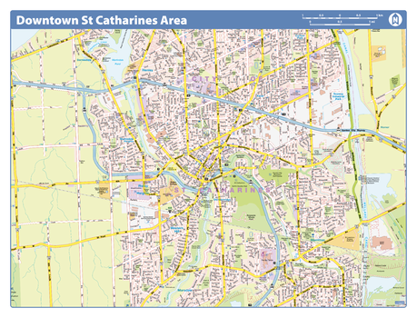
St Catharines Downtown - Compact
Map of downtown St Catharines showing all roads, road names, political boundaries, transit, points of interest, parks, schools, churches, public buildings and landmarks.
Page Size: 21.5 x 16.25 in (546 x 413 mm)