Kartographia
Ukraine Physical Wall Map - Large - Ukrainian
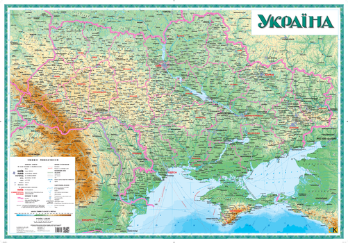
This large Ukrainian-language map of Ukraine illustrates topographic information about the natural landscape (relief, sea bed, hydrography) as well as social and economic features such as localities, administrative regions and railroads. This physical style map illustrates changes in depth and height with colour.
Page Size: 57.25 x 40 in (1450 x 1010 mm)
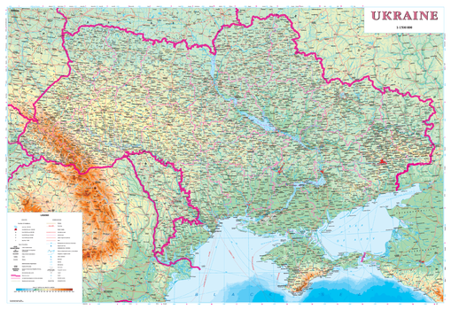
Ukraine Physical Wall Map - Latynka
This overview map of Ukraine illustrates spatial information about the natural landscape (relief, sea bed, hydrography) as well as social and economic features such as localities, administrative regions and railroads). This physical style map illustrates changes in depth and height with colour.
Place names on the map are written in the Ukrainian Latin alphabet (Latynka). The map legend is in English.
Page Size: 38 x 26 in (960 x 660 mm)
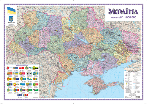
Ukraine Political and Administrative Wall Map - Large - Ukrainian
This large Ukrainian-language wall map presents the present-day political and territorial division of Ukraine: oblasts, raions, territories subordinated to cities of oblast subordinance, and modern place names.
Page Size: 58.75 x 41.5 in (1490 x 1050 mm)
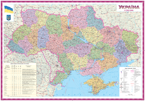
Ukraine Political and Administrative Wall Map - Ukrainian
This Ukrainian-language wall map presents the present-day political and territorial division of Ukraine with post-communism place names of Ukraine.
Page Size: 38.25 x 26.25 in (966 x 666 mm)
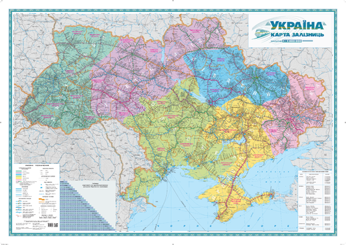
Ukraine Railways Wall Map - Ukrainian - Large
This large Ukrainian-language map illustrates highly detailed information of the railway system of Ukraine. Railway stations (passenger, junction and line stations), crossing points, platforms, stopping points and distances in kilometers between junction and line stations are indicated on the map. There is a list of motor vehicle crossing points at the national border of Ukraine. The six railway administrative regions of Ukraine are identified by different colours.
Page Size: 58.75 x 41.5 in (1490 x 1050 mm)
Ukraine Tourist Wall Map - Latynka - Large
Illustrated on this map of Ukraine are places of historical, architectural, cultural and archaeological significance. Tourist infrastructure such as museums and tourist service facilities are identified.
Place names on the map are written in the Ukrainian Latin alphabet (Latynka). The map legend is in English, French and German.
Page Size: 43.5 x 29.75 in (1102 x 750 mm)
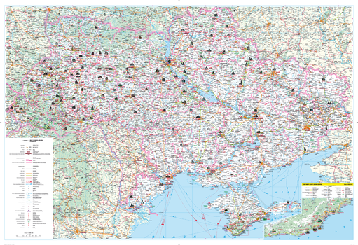
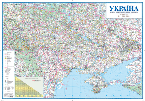
Ukraine Transportation Network Wall Map - Large
This large wall map shows detailed road network and transportation information of the Ukraine. Information on the map includes features such as road classification, customs checkpoints, fuel stops and distances along roads. The map uses the modern classification of roads for the Ukraine. Recent updating of information using aerial surveys ensures the information on the map is current.
Place names on this map are written in the Ukrainian Latin alphabet (Latynka). The map legend is in English.
Page Size: 55 x 38.25 in (1396 x 966 mm)
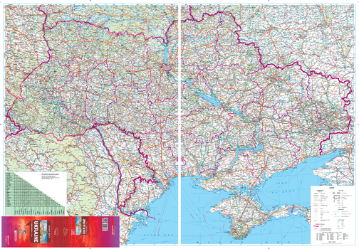
Ukraine Transportation Network Wall Map - Ukrainian - Large
This large Ukrainian-language wall map shows detailed road network and transportation information of Ukraine. Information on the map includes features such as road classification, customs checkpoints, fuel stops and distances along roads. The map uses the modern classification of roads for the Ukraine. Recent updating of information using aerial surveys ensures the information on the map is current.
Page Size: 55.5 x 38.5 in (1408 x 978 mm)
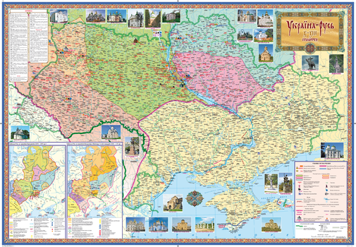
Ukraine-Russia Historical Wall Map X-XIII centuries - Ukrainian
This Ukrainian-language wall map presents territories of the ancient principalities of Ukraine: historical towns where Russian monuments have been preserved. The map shows all towns which were mentioned in the Chronicles - annual accounts of events and stories - whose compilation started in the 10th century. Also included are towns found through archaeological study of the region. The historical place names, the date of their first mention in the Chronicles, and places of battles are included.
An inset map presents the KievanRus under the rule of the prominent princes: Yaroslav the Wise and Volodymyr Monomakh. Map margins contain pictures of Old Russian monuments.
Page Size: 38 x 26 in (960 x 660 mm)
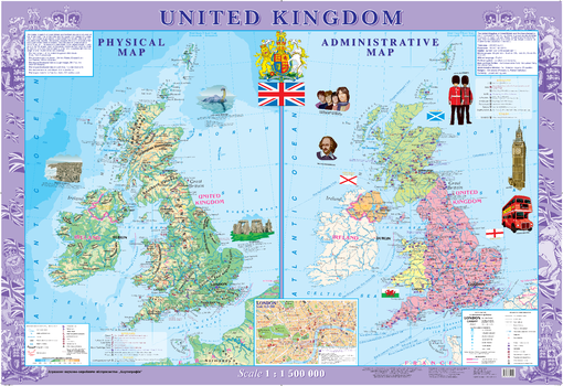
United Kingdom Wall Map - Physical and Political - Extra Large
This decorative wall map of the United Kingdom includes both a physical map and a political map. Also included is an inset map of London at a scale of 1:30 000.
Shown on the physical map are famous nature monuments, parks and reserves, historical and archeological features, caves, climatic spas, zoos and other interesting features.
The political map highlights the four kingdoms that make up the country; England, Scotland, Wales and Northern Ireland. Features of interests identified on the map include architectural and historical monuments, middle age abbeys, palaces and castles, museums and theaters, places of birth of prominent people and other interesting features.
Page Size: 62.5 x 43 in (1586 x 1086 mm)
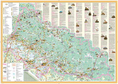
Zakarpatska oblast Wall Map - Ukrainian
This Ukrainian-language wall map features important architectural sites, monuments, cultural and entertainment establishments, reserves, national parks, wildlife areas, nature monuments and tourist centers of Zakarpatska oblast. Also included is a place name distance index and photographs and descriptions of notable historic features.
Page Size: 33.25 x 23.25 in (840 x 590 mm)