Globe Turner
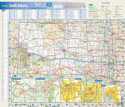
South Dakota State Wall Map
This colorful, easy-to-read state map of South Dakota identifies all major thoroughfares, secondary roads, freeway interchanges, rest areas, distance markers, landmarks, recreational areas, and more. Shaded relief on the state map provides a three-dimensional sense of South Dakota’s topography. Detailed city inset maps of Pierre, Rapid City and Sioux Falls are based on the latest street information from our cartographic experts. The map also includes up-to-date insets of the Black Hills area. County and city indices make it simple to locate even the smallest town.
Page Size: 17.75 x 15.25 in (451 x 387 mm)
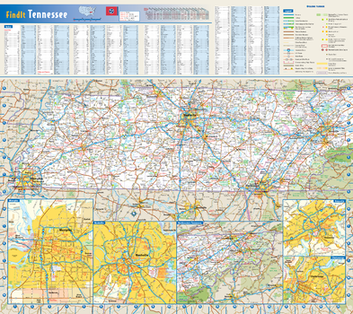
Tennessee State Wall Map
This colorful, easy-to-read state map of Tennessee identifies all major thoroughfares, secondary roads, freeway interchanges, rest areas, distance markers, landmarks, recreational areas, and more. Shaded relief on the state map provides a three-dimensional sense of Tennessee's topography. Detailed city inset maps of Chattanooga, Knoxville, Memphis, and Nashville are based on the latest street information from our cartographic experts. County and city indices make it simple to locate even the smallest town.
Page Size: 20.75 x 18.5 in (524 x 467 mm)
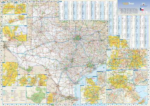
Texas State Wall Map
This colorful, easy-to-read state map of Texas identifies all major thoroughfares, secondary roads, freeway interchanges, rest areas, distance markers, landmarks, recreational areas, and more. Shaded relief on the state map provides a three-dimensional sense of Texas' topography. Detailed city inset maps of Abilene, Amarillo, Austin, Beaumont, Corpus Christi, Dallas / Fort Worth, El Paso, Houston / Galveston, Laredo, Lubbock, McAllen, Odessa / Midland, San Antonio, Texarkana, and Waco are based on the latest street information from our cartographic experts. The map also includes up-to-date insets of downtown Dallas, downtown Houston, downtown San Antonio, and Big Bend National Park. County and city indices make it simple to locate even the smallest town.
Page Size: 34.5 x 24.75 in (876 x 622 mm)
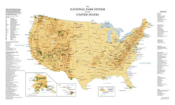
USA National Park Service Large Wall Map
Perfect for home, business, or school, this United States National Park Service wall map shows the location of all sites operated by the National Park system in the continental United States, Alaska, Hawaii, Puerto Rico, and the U.S. Virgin Islands. Special features include colored relief and a white decorative border.
Page Size: 30 x 18 in (762 x 457 mm)

USA National Park Service Wall Map
Perfect for home, business, or school, this United States National Park Service wall map shows the location of all sites operated by the National Park system in the continental United States, Alaska, Hawaii, Puerto Rico, and the U.S. Virgin Islands. Special features include colored relief and a white decorative border.
Page Size: 20 x 12 in (508 x 305 mm)
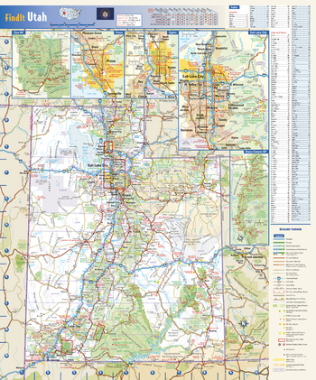
Utah State Wall Map
This colorful, easy-to-read state map of Utah identifies all major thoroughfares, secondary roads, freeway interchanges, rest areas, distance markers, landmarks, recreational areas, and more. Shaded relief on the state map provides a three-dimensional sense of Utah’s topography. Detailed city inset maps of Provo, Ogden, and Salt Lake City are based on the latest street information from our cartographic experts. Up-to-date insets of Bryce Canyon National Park and Zion National Park provide must-see information on these tourist areas. County and city indices make it simple to locate even the smallest town. City type sizes reflect the 2020 U.S. Census.
Page Size: 14.75 x 17.75 in (375 x 451 mm)

Virginia State Wall Map
This colorful, easy-to-read state map of Virginia identifies all major thoroughfares, secondary roads, freeway interchanges, rest areas, distance markers, landmarks, recreational areas, and more. Shaded relief on the state map provides a three-dimensional sense of Virginia's topography. Detailed city inset maps of Charlottesville, Lynchburg, Norfolk/Virginia Beach, Petersburg, Richmond, Roanoke, and Williamsburg are based on the latest street information from our cartographic experts. County and city indices make it simple to locate even the smallest town.
Page Size: 30.75 x 19.25 in (781 x 489 mm)
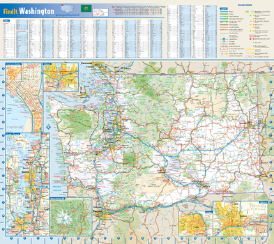
Washington State Wall Map
This colorful, easy-to-read state map of Washington identifies all major thoroughfares, secondary roads, freeway interchanges, rest areas, distance markers, landmarks, recreational areas, and more. Shaded relief on the state map provides a three-dimensional sense of Washington's topography. Detailed city inset maps of Olympia, Seattle, Spokane, and Yakima are based on the latest street information from our cartographic experts. Up-to-date insets of Mount Rainier National Park and downtown Seattle provide must-see information on these tourist areas. County and city indices make it simple to locate even the smallest town.
Page Size: 20.75 x 18.5 in (524 x 467 mm)
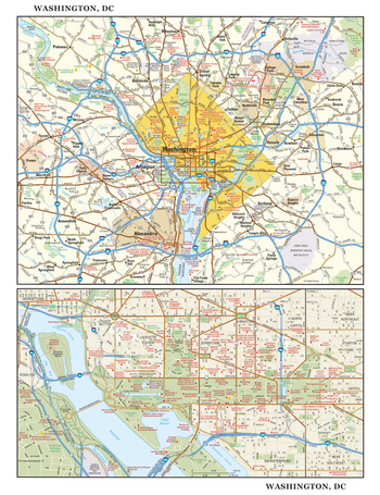
Washington, DC Wall Map, large
This detailed reference map combines two maps in one - a regional map of the District of Columbia and surrounding Maryland and Virginia suburbs plus a street-level map of downtown Washington. The regional map shows the area’s cities and towns, highways and roads, and a variety of points of interest. Encompassing the historic area between Georgetown and Capitol Hill - including The Mall, The White House, the Capitol Building, and a part of Arlington National Cemetery in Virginia - the downtown map shows highways, streets, parks, landmarks, and other points of interest. Also available in a small size of 14.625" high X 11.25" wide.
Page Size: 22.75 x 29.5 in (572 x 743 mm)
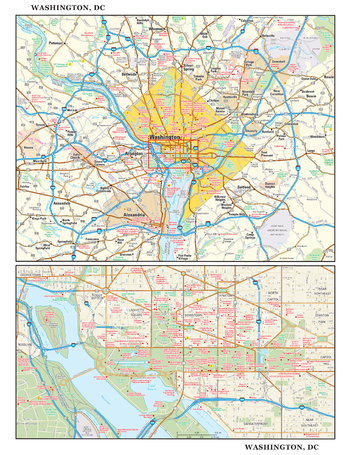
Washington, DC Wall Map, small
This detailed reference map combines two maps in one - a regional map of the District of Columbia and surrounding Maryland and Virginia suburbs plus a street-level map of downtown Washington. The regional map shows the area’s cities and towns, highways and roads, and a variety of points of interest. Encompassing the historic area between Georgetown and Capitol Hill - including The Mall, The White House, the Capitol Building, and a part of Arlington National Cemetery in Virginia - the downtown map shows highways, streets, parks, landmarks, and other points of interest. Also available in a large size of 29.25" high X 22.50" wide.
Page Size: 11.25 x 14.75 in (286 x 371 mm)
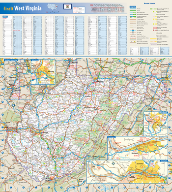
West Virginia State Wall Map
This colorful, easy-to-read state map of West Virginia identifies all major thoroughfares, secondary roads, freeway interchanges, rest areas, distance markers, landmarks, recreational areas, and more. Shaded relief on the state map provides a three-dimensional sense of West Virginia's topography. Detailed city inset maps of Charleston, Huntington, Morgantown, and Wheeling are based on the latest street information from our cartographic experts. County and city indices make it simple to locate even the smallest town.
Page Size: 16.5 x 18.5 in (419 x 467 mm)
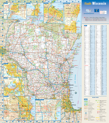
Wisconsin State Wall Map
This colorful, easy-to-read state map of Wisconsin identifies all major thoroughfares, secondary roads, freeway interchanges, rest areas, distance markers, landmarks, recreational areas, and more. Shaded relief on the state map provides a three-dimensional sense of Wisconsin's topography. Detailed city inset maps of Appleton, Green Bay, Madison, Milwaukee, Oshkosh, and Racine/Kenosha are based on the latest street information from our cartographic experts. County and city indices make it simple to locate even the smallest town.
Page Size: 18.5 x 20.75 in (467 x 524 mm)
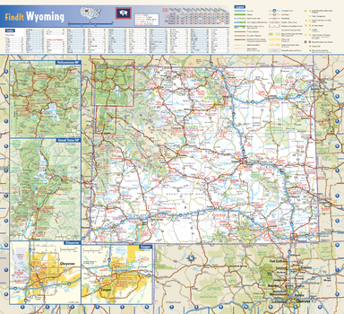
Wyoming State Wall Map
This colorful, easy-to-read state map of Wyoming identifies all major thoroughfares, secondary roads, freeway interchanges, rest areas, distance markers, landmarks, recreational areas, and more. Shaded relief on the state map provides a three-dimensional sense of Wyoming’s topography. Detailed city inset maps of Casper and Cheyenne are based on the latest street information from our cartographic experts. The map also includes up-to-date insets of Grand Teton National Park and Yellowstone National Park. County and city indices make it simple to locate even the smallest town. City type sizes reflect the 2020 U.S. Census.
Page Size: 16.75 x 15.25 in (425 x 387 mm)