Globe Turner
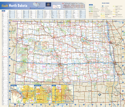
North Dakota State Wall Map
This colorful, easy-to-read state map of North Dakota identifies all major thoroughfares, secondary roads, freeway interchanges, rest areas, distance markers, landmarks, recreational areas, and more. Shaded relief on the state map provides a three-dimensional sense of North Dakota’s topography. Detailed city inset maps of Bismarck, Fargo and Grand Forks are based on the latest street information from our cartographic experts. County and city indices make it simple to locate even the smallest town. City type sizes reflect the 2020 U.S. Census.
Page Size: 17.75 x 15.25 in (451 x 387 mm)
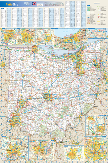
Ohio State Wall Map
This colorful, easy-to-read state map of Ohio identifies all major thoroughfares, secondary roads, freeway interchanges, route numbers, landmarks, recreational areas, and more. Shaded relief on the state map provides a three-dimensional sense of Ohio's topography. Detailed inset maps of Akron, Canton, Cincinnati, Cleveland, Columbus, Dayton, Springfield, Toledo and Youngstown are based on the latest street information from our cartographic experts. County and city indices make it simple to locate even the smallest town.
Page Size: 20.75 x 31.25 in (527 x 794 mm)
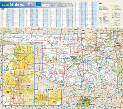
Oklahoma State Wall Map
This colorful, easy-to-read state map of Oklahoma identifies all major thoroughfares, secondary roads, freeway interchanges, rest areas, distance markers, landmarks, recreational areas, and more. Shaded relief on the state map provides a three-dimensional sense of Oklahoma's topography. Detailed inset maps of Lawton, Oklahoma City, Stillwater, and Tulsa are based on the latest street information from our cartographic experts. County and city indices make it simple to locate even the smallest town.
Page Size: 20.75 x 18.5 in (524 x 467 mm)
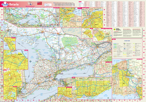
Ontario Wall Map
This colorful, easy-to-read province map of Ontario identifies all major thoroughfares, secondary roads, freeway interchanges, rest areas, distance markers, landmarks, recreational areas, and more. Shaded relief on the province map provides a three-dimensional sense of Ontario's topography. Detailed city inset maps of Guelph, Hamilton, Kitchener / Waterloo / Cambridge, London, Niagara Region, North Bay, Ottawa / Gatineau, QC, Sault Ste. Marie, Sudbury, Toronto, and Windsor / Detroit, MI are based on the latest street information from our cartographic experts. The map also includes up-to-date insets of downtown Toronto, and Northern Ontario, as well as the latest border crossing information. A city index makes it simple to locate even the smallest town.
Page Size: 19.25 x 27.5 in (489 x 699 mm)

Oregon State Wall Map
This colorful, easy-to-read state map of Oregon identifies all major thoroughfares, secondary roads, freeway interchanges, rest areas, distance markers, landmarks, recreational areas, and more. Shaded relief on the state map provides a three-dimensional sense of Oregon’s topography. Detailed city inset maps of Eugene, Portland, and Salem are based on the latest street information from our cartographic experts. An up-to-date inset of Crater Lake National Park provides must-see information on this tourist area. County and city indices make it simple to locate even the smallest town. City type sizes reflect the 2020 U.S. Census.
Page Size: 20.75 x 18.5 in (524 x 467 mm)

Pacific-Centered World Wall Map
Perfect for home, business, or school, this Pacific Ocean-centered World Wall Map combines bright, attractive colors with high-detailed cartography. Details on this World Wall Map include: international boundaries and national capitals along with other major cities; major physical features such as mountain ranges, major mountain peaks, island chains, and deserts; and major water features such as oceans, seas, gulfs, and rivers. Special features include ivory-colored oceans and a white decorative border. This map of the world uses the Miller projection.
Page Size: 61 x 33.5 in (1549 x 851 mm)
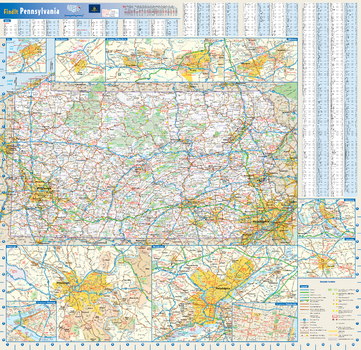
Pennsylvania State Wall Map
This colorful, easy-to-read state map of Pennsylvania identifies all major thoroughfares, secondary roads, freeway interchanges, rest areas, distance markers, landmarks, recreational areas, and more. Shaded relief on the state map provides a three-dimensional sense of Pennsylvania's topography. Detailed city inset maps of Allentown, Erie, Harrisburg, Lancaster, Philadelphia, Pittsburgh, Scranton/Wilkes-Barre, and State College are based on the latest street information from our cartographic experts. Up-to-date insets of center city Philadelphia and downtown Pitttsburgh provide must-see information on these tourist areas. County and city indices make it simple to locate even the smallest town.
Page Size: 25 x 24 in (629 x 610 mm)
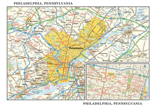
Philadelphia, Pennsylvania Wall Map, large
This detailed reference map combines two maps in one - a map of the greater Philadelphia area plus a street-level map of historic, downtown Philadelphia. The metropolitan map shows the area’s cities and towns, highways and roads, and a variety of points of interest. The map includes the surrounding suburban cities in Pennsylvania and New Jersey. The downtown map, which includes Independence National Historical Park, shows highways, streets, parks, landmarks, and other points of interest. Society Hill and Chinatown are among the neighborhoods featured on this map. Also available in a small size of 7.75" high X 11.25" wide.
Page Size: 22.75 x 15.5 in (572 x 394 mm)
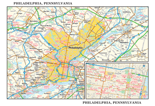
Philadelphia, Pennsylvania Wall Map, small
This detailed reference map combines two maps in one - a map of the greater Philadelphia area plus a street-level map of historic, downtown Philadelphia. The metropolitan map shows the area’s cities and towns, highways and roads, and a variety of points of interest. The map includes the surrounding suburban cities in Pennsylvania and New Jersey. The downtown map, which includes Independence National Historical Park, shows highways, streets, parks, landmarks, and other points of interest. Society Hill and Chinatown are among the neighborhoods featured on this map. Also available in a large size of 15.50" high X 22.50" wide.
Page Size: 11.25 x 7.75 in (286 x 197 mm)

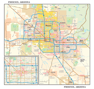
Phoenix, Arizona Wall Map, large
This detailed reference map combines two maps in one - a regional map of the Phoenix metropolitan area plus a street-level map of downtown Phoenix. The regional map depicts the area’s cities and towns, highways and roads, and a variety of points of interest. Scottsdale, Tempe, and Mesa are among the cities near Phoenix that are featured on this map. The map is beautifully rendered with terrain relief. The highly detailed inset of central Phoenix shows highways, streets, parks, landmarks, and other points of interest. Also available in a small size of 10.625" high X 11.25" wide.
Page Size: 22.75 x 21.5 in (572 x 540 mm)
Phoenix, Arizona Wall Map, small
This detailed reference map combines two maps in one - a regional map of the Phoenix metropolitan area plus a street-level map of downtown Phoenix. The regional map depicts the area’s cities and towns, highways and roads, and a variety of points of interest. Scottsdale, Tempe, and Mesa are among the cities near Phoenix that are featured on this map. The map is beautifully rendered with terrain relief. The highly detailed inset of central Phoenix shows highways, streets, parks, landmarks, and other points of interest. Also available in a large size of 21.25" high X 22.50" wide.
Page Size: 11.25 x 10.75 in (286 x 270 mm)
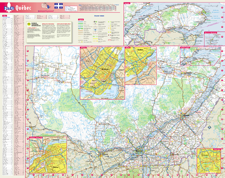
Québec Wall Map, in English
This colorful, easy-to-read province map of Québec identifies all major thoroughfares, secondary roads, freeway interchanges, rest areas, distance markers, landmarks, recreational areas, and more. Shaded relief on the province map provides a three-dimensional sense of Québec's topography. Detailed city inset maps of Montréal, Québec, Gatineau / Ottawa, ON and Sherbrooke are based on the latest street information from our cartographic experts. The map also includes up-to-date insets of Eastern Québec, Gaspésie, and the Îles-de-la-Madeleine, as well as the latest border crossing information. A city index makes it simple to locate even the smallest town.
Page Size: 19 x 24 in (483 x 610 mm)
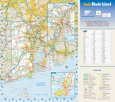
Rhode Island State Wall Map
This colorful, easy-to-read state map of Rhode Island identifies all major thoroughfares, secondary roads, freeway interchanges, rest areas, distance markers, landmarks, recreational areas, and more. Shaded relief on the state map provides a three-dimensional sense of Rhode Island's topography. Detailed city inset maps of Newport and Providence are based on the latest street information from our cartographic experts. County and city indices make it simple to locate even the smallest town.
Page Size: 15.75 x 14 in (400 x 356 mm)
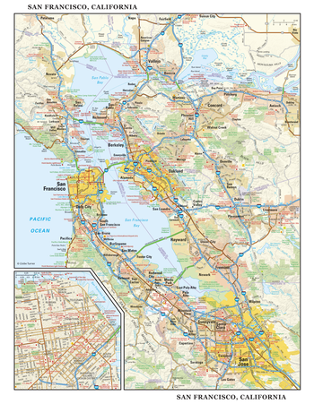
San Francisco, California Wall Map, large
This detailed reference map combines two maps in one - a regional map of the San Francisco Bay area plus a street-level map of downtown San Francisco. The regional map includes the major metropolitan areas of San Francisco, Oakland, and San Jose. The area’s cities and towns, highways and roads, and a variety of points of interest are depicted. The map is beautifully rendered with terrain relief. The inset map of downtown San Francisco shows highways, streets, cable car lines, parks, landmarks, and other points of interest. Chinatown, Telegraph Hill, Nob Hill, and North Beach are among the neighborhoods shown on this map. Also available in a large size of 29.00" high X 22.50" wide.
Page Size: 22.75 x 29 in (572 x 737 mm)
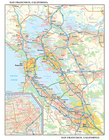
San Francisco, California Wall Map, small
This detailed reference map combines two maps in one - a regional map of the San Francisco Bay area plus a street-level map of downtown San Francisco. The regional map includes the major metropolitan areas of San Francisco, Oakland, and San Jose. The area’s cities and towns, highways and roads, and a variety of points of interest are depicted. The map is beautifully rendered with terrain relief. The inset map of downtown San Francisco shows highways, streets, cable car lines, parks, landmarks, and other points of interest. Chinatown, Telegraph Hill, Nob Hill, and North Beach are among the neighborhoods shown on this map. Also available in a large size of 29.00" high X 22.50" wide.
Page Size: 11.25 x 14.5 in (286 x 368 mm)
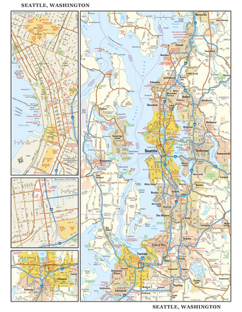
Seattle, Washington Wall Map, large
This detailed reference map combines four maps in one - a regional map of the Seattle metropolitan area, street-level maps of downtown Seattle and Tacoma, and an area map of Olympia, Washington - Washington’s state capitol, located southwest of Tacoma. The regional maps of Seattle and Olympia depict the area’s cities and towns, highways and roads, and a variety of points of interest. Bainbridge Island, Bremerton, Bellevue, and Everett are among the cities surrounding Seattle that are featured on the Seattle regional map. The highly detailed insets of central Seattle and Tacoma show highways, streets, parks, landmarks, and other points of interest. The Seattle Center, Belltown, and Pioneer Square are among the neighborhoods featured on the downtown Seattle map. Also available in a small size of 14.50" high X 11.25" wide
Page Size: 22.75 x 29 in (572 x 737 mm)
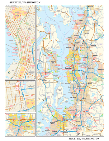
Seattle, Washington Wall Map, small
This detailed reference map combines four maps in one - a regional map of the Seattle metropolitan area, street-level maps of downtown Seattle and Tacoma, and an area map of Olympia, Washington - Washington’s state capitol, located southwest of Tacoma. The regional maps of Seattle and Olympia depict the area’s cities and towns, highways and roads, and a variety of points of interest. Bainbridge Island, Bremerton, Bellevue, and Everett are among the cities surrounding Seattle that are featured on the Seattle regional map. The highly detailed insets of central Seattle and Tacoma show highways, streets, parks, landmarks, and other points of interest. The Seattle Center, Belltown, and Pioneer Square are among the neighborhoods featured on the downtown Seattle map. Also available in a large size of 29.00" high X 22.50" wide
Page Size: 11.25 x 14.5 in (286 x 368 mm)
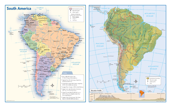
South America Political & Physical Continent Map
This map of the South American continent combines two maps in one - a vivid political map of South America showing all of the countries and major cities as well as a colorful topographic physical map depicting all of the major physical features in South America, including a cross-continent elevation profile. The political map includes a call-out box with interesting facts about the continent.
Page Size: 17 x 10.75 in (432 x 271 mm)
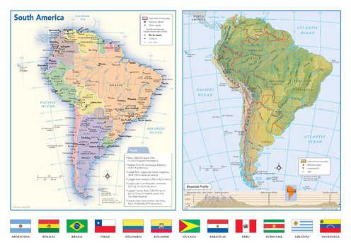
South America Political & Physical Continent Map with Country Flags
This map of the South American continent combines two maps in one - a vivid political map of South America showing all of the countries and major cities as well as a colorful topographic physical map depicting all of the major physical features in South America, including a cross-continent elevation profile. The political map includes a call-out box with interesting facts about the continent. The map also includes all 12 flags each South American country.
Page Size: 17 x 12 in (432 x 305 mm)
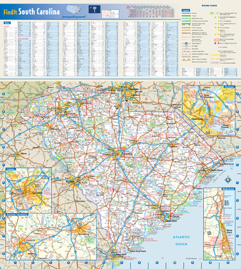
South Carolina State Wall Map
This colorful, easy-to-read state map of South Carolina identifies all major thoroughfares, secondary roads, freeway interchanges, rest areas, distance markers, landmarks, recreational areas, and more. Shaded relief on the state map provides a three-dimensional sense of South Carolina's topography. Detailed city inset maps of Charleston, Columbia, Greenville-Spartanburg, and Myrtle Beach are based on the latest street information from our cartographic experts. County and city indices make it simple to locate even the smallest town.
Page Size: 16.5 x 18.5 in (419 x 467 mm)