Global Mapping
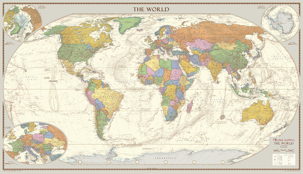
Antique Style World Map - Extra Large
The 1:30M version won Best Printed Map from the British Cartographic Society (BCS) who also awarded it the BCS Cup for the best overall map. The classic design of muted colours and hill shading give an antique feel to the map. The map features insets of the two polar regions as well as an enlargement of Central Europe, all with an increased level of detail than the medium map. Uniquely, the map also includes explanatory text about the Tropics of Cancer and Capricorn, the Arctic and Antarctic Circles as well as an Analemma which shows which day of the year the sun is directly overhead and how sun time compares to clock time.
Page Size: 78.75 x 45.5 in (2000 x 1150 mm)
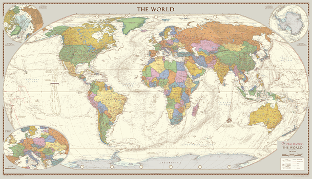
Antique Style World Map - Large
The classic design of muted colours and hill shading give an antique feel to the map. The map features insets of the two polar regions as well as an enlargement of Central Europe. Uniquely, the map also includes explanatory text about the Tropics of Cancer and Capricorn, the Arctic and Antarctic Circles as well as an Analemma which shows which day of the year the sun is directly overhead and how sun time compares to clock time.
Best Printed Map 2013 from the British Cartographic Society (BCS) who also awarded it the BCS Cup for the best overall map.
Page Size: 52.5 x 30.25 in (1333 x 766 mm)
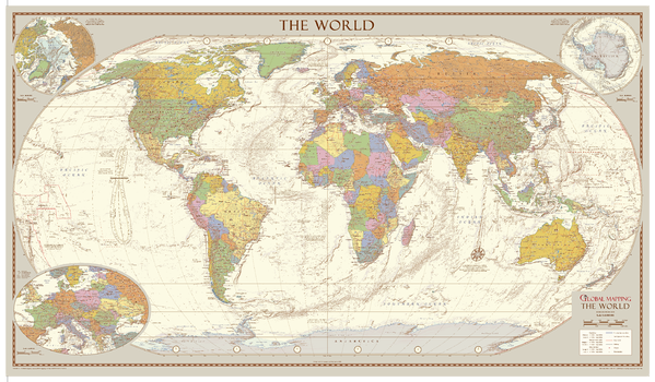
Antique Style World Map - Medium
A classic design for this map from Global Mapping, the larger version won the award for Best Wall Map 2013 from the British Cartographic Society. This very attractive map features insets of the two polar regions as well as an enlargement of Central Europe. Uniquely, the map also includes explanatory text about the Tropics of Cancer and Capricorn, the Arctic and Antarctic Circles as well as an Analemma which shows which day of the year the sun is directly overhead and how sun time compares to clock time. The muted colours and hill shading give an antique feel to the map.
ISBN 9781905755738
Page Size: 39.25 x 22.75 in (1000 x 575 mm)
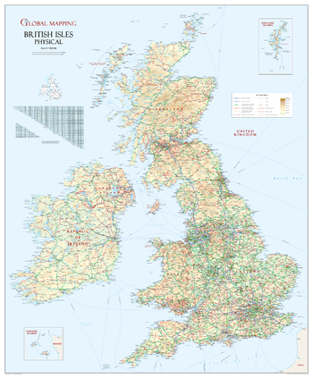
British Isles Physical Wall Map
Classic British Isles wall map ideal for schools or the office. This unique British Isles map shows the UK and all its neighbours in their correct geographical position! The beautiful colouration makes this a truly delightful presentation. Intricately detailed.
ISBN 9781905755196
Page Size: 35 x 43.5 in (914 x 1105 mm)
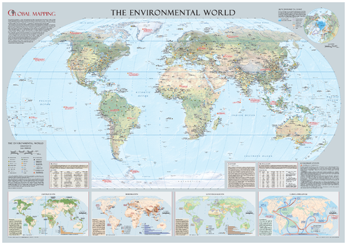
Environmental World Wall Map - Large
Educational wall map from Global Mapping highlighting the threats human activity has on our planet has picked up two prestigious awards from The British Cartographic Society (BCS). It won the Stanford's Award for Best Paper Map with the judges comments: "Good symbology, size, does the job of clearly conveying the environmental issues facing our planet, a top quality piece of cartography." This informative educational wall map comes from award winning publishers Global Mapping. Pollution (including the devastating BP Deep Horizon Oil Spill in the Gulf of Mexico in 2010-the second worst recorded), Deforestation, Urbanisation, Environment Hotspots, Coastlines at risk from rising sea levels are just some of the topics covered. Beautifully designed by top map designer Mary Spence, MBE, this map makes the perfect companion to 'The Dynamic World'
Page Size: 52.5 x 36.75 in (1333 x 933 mm)
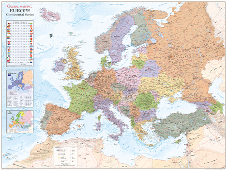
Europe Political Wall Map
Political map of Europe overlaid on a shanded relief, with information panels on the European Union, language, time zones, international dialling codes and 2004 population estimates. Map features include cities and towns, peaks, airports and major road and railway network features.
Page Size: 53 x 39.5 in (1340 x 1000 mm)
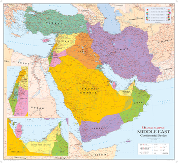
Middle East Wall Map
Covering probably the most volatile region in the world, the map includes enlarged insets of the most populated areas. The ideal map for following events in the region.
ISBN 9781905755752
Page Size: 42.5 x 39 in (1080 x 990 mm)

Political World Wall Map, French Language
Political World Wall Map in French. Carte des murs du monde politique en français.
Page Size: 40.75 x 27 in (1029 x 684 mm)
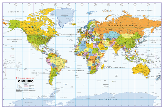
Political World Wall Map, Portuguese Language
Political World Wall Map in Portuguese. Mapa do Muro Mundial Político em Português.
Page Size: 40.75 x 27 in (1029 x 684 mm)

Political World Wall Map, Spanish Language
Political World Wall Map in Spanish. Mapa político del muro mundial en español.
Page Size: 40.75 x 27 in (1029 x 684 mm)
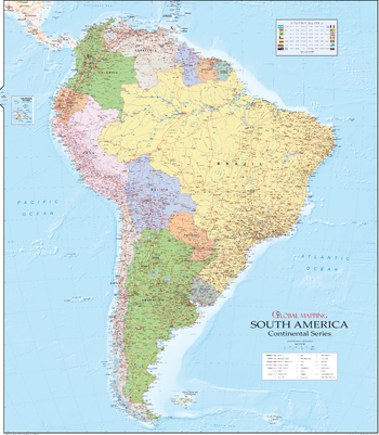
South America Wall Map
The beautiful continent of South America is captured here in Global Mapping's equally beautiful design, the map was created by award winning Mary Spence MBE
Page Size: 39 x 45 in (990 x 1140 mm)
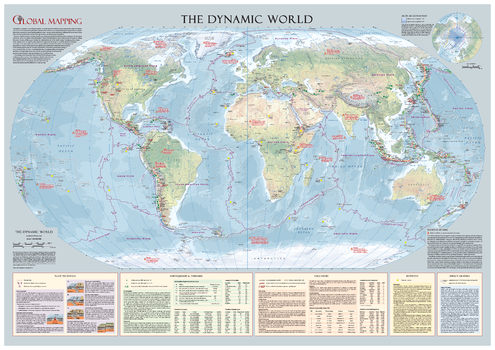
The Dynamic World Wall Map - Large
Learn how natural phenomena creates your dynamic planet. The map features detailed descriptions of Plate Tectonics, earthquakes & tsunamis, volcanoes, hotspots and impact craters. There is also a dedicated inset looking at one of the most emotive subjects in today's news; Global Warming and the melting Arctic ice cap. Beautifully designed, the educational value of this map is immense and will appeal to young and old alike.
Page Size: 39.5 x 27.75 in (1000 x 700 mm)
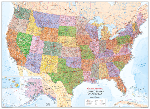
USA Wall Map - State Map with Relief
This excellent wall map of USA encompasses all the beautiful design and accuracy you would expect from Global Mapping. The detailed map features railways, highways, canals, state and county boundaries as well as denoting the time zones. Hawaii and Alaska are shown in insets and the stunning terrain really brings the map to life
Page Size: 55.25 x 40.25 in (1400 x 1020 mm)