Collins

Index for Collins Cotswolds Map
Index to towns, villages and places of interest to accompany the Collins Cotswolds Map
Page Size: 32 x 22.25 in (810 x 560 mm)

Index for Collins Devon Map
Index to towns, villages and places of interest to accompany the Collins Devon Map
Page Size: 28.5 x 22.25 in (720 x 560 mm)
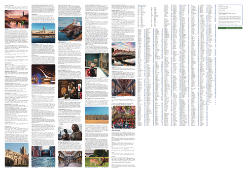
Index for Collins Dublin Map
General tourist information and photographs of the vibrant city of Dublin along with detailed street index for the Collins Dublin Map.
Page Size: 32 x 22.25 in (810 x 560 mm)

Index for Collins Edinburgh Map
General tourist information and photographs of the vibrant city of Edinburgh along with detailed street index for the Collins Edinburgh Map.
Page Size: 32 x 22.25 in (810 x 560 mm)
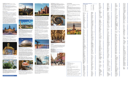
Index for Collins Glasgow Map
General tourist information and photographs of the vibrant city of Glasgow along with detailed street index for the Collins Glasgow Map.
Page Size: 28.5 x 22.25 in (720 x 560 mm)
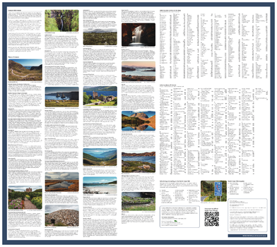
Index for Collins NC500 Map
General tourist information and photographs of NC500 along with detailed street index for the Collins NC500 Map.
Page Size: 25 x 22.25 in (630 x 560 mm)
Index for Collins Northern Ireland Map
General tourist information and photographs of Northern Ireland along with detailed street index for the Collins Northern Ireland Map.
Page Size: 28.5 x 22.25 in (720 x 560 mm)
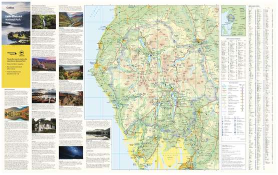
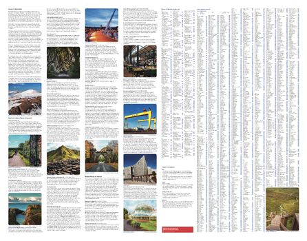
Lake District National Park Map
With clear mapping and a high level of detail, explore the Lake District National Park easily with maps from Collins. This map identifies key park, tourist, and travel information, presented alongside a selection of photographs, making it an ideal companion for those exploring this beautiful area of Northwest England.
Page Size: 35.5 x 22.25 in (900 x 560 mm)
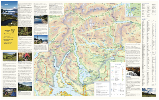
Loch Lomond National Park Map
With clear mapping and a high level of detail, explore the Loch Lomond National Park easily with maps from Collins. This map identifies key park, tourist, and travel information, presented alongside a selection of photographs, making it an ideal companion for those exploring this beautiful area of Scotland.
Page Size: 35.5 x 22.25 in (900 x 560 mm)
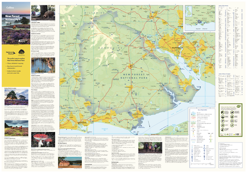
New Forest National Park Map
With clear mapping and a high level of detail, explore the New Forest National Park easily with maps from Collins. This map identifies key park, tourist, and travel information, presented alongside a selection of photographs, making it an ideal companion for those exploring this beautiful area of Southern England.
Page Size: 32 x 22.25 in (810 x 560 mm)
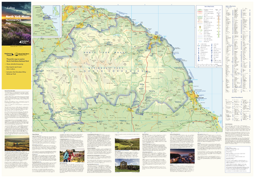
North York Moors National Park Map
With clear mapping and a high level of detail, explore North York Moors National Park easily with maps from Collins. This map identifies key park, tourist, and travel information, presented alongside a selection of photographs, making it an ideal companion for those exploring this beautiful area of Northern Yorkshire.
Page Size: 32 x 22.25 in (810 x 560 mm)
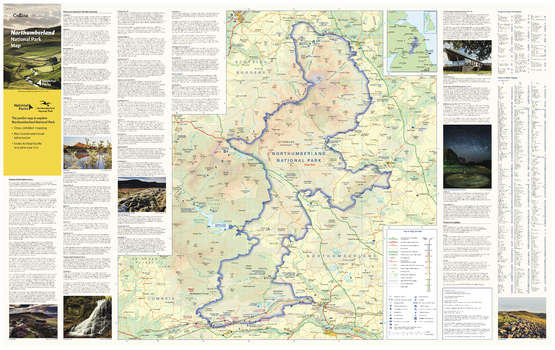
Northumberland National Park Map
With clear mapping and a high level of detail, explore the Northumberland National Park easily with maps from Collins. This map identifies key park, tourist, and travel information, presented alongside a selection of photographs, making it an ideal companion for those exploring this beautiful area of Northern England.
Page Size: 35.5 x 22.25 in (900 x 560 mm)
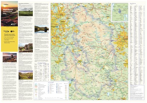
Peak District National Park Map
With clear mapping and a high level of detail, explore the Peak District National Park easily with maps from Collins. This map identifies key park, tourist, and travel information, presented alongside a selection of photographs, making it an ideal companion for those exploring this beautiful area of England.
Page Size: 32 x 22.25 in (810 x 560 mm)
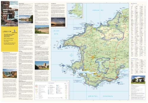
Pembrokeshire Coast National Park Map
With clear mapping and a high level of detail, explore Pembrokeshire Coast National Park easily with maps from Collins. This map identifies key park, tourist, and travel information, presented alongside a selection of photographs, making it an ideal companion for those exploring this beautiful area of West Wales.
Page Size: 32 x 22.25 in (810 x 560 mm)
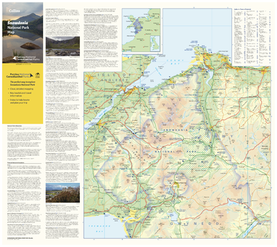
Snowdonia National Park Map - North
With clear mapping and a high level of detail, explore Snowdonia National Park easily with maps from Collins. This map identifies key park, tourist, and travel information, presented alongside a selection of photographs, making it an ideal companion for those exploring this beautiful area of West Wales.
Page Size: 25 x 22.25 in (630 x 560 mm)
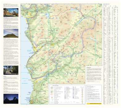
Snowdonia National Park Map - South
With clear mapping and a high level of detail, explore Snowdonia National Park easily with maps from Collins. This map identifies key park, tourist, and travel information, presented alongside a selection of photographs, making it an ideal companion for those exploring this beautiful area of West Wales.
Page Size: 25 x 22.25 in (630 x 560 mm)

South Downs National Park Map - East
With clear mapping and a high level of detail, explore the South Downs National Park easily with maps from Collins. This map identifies key park, tourist, and travel information, presented alongside a selection of photographs, making it an ideal companion for those exploring this beautiful area of South East England.
Page Size: 25 x 22.25 in (630 x 560 mm)
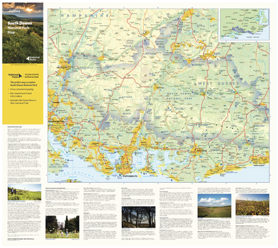
South Downs National Park Map - West
With clear mapping and a high level of detail, explore the South Downs National Park easily with maps from Collins. This map identifies key park, tourist, and travel information, presented alongside a selection of photographs, making it an ideal companion for those exploring this beautiful area of South East England.
Page Size: 25 x 22.25 in (630 x 560 mm)
UK Postcode Sectors
Detailed and up-to-date postcode data. Detailed boundary information for approximately 9,500 Sector postcodes in England, Wales, Scotland, Northern Ireland, the Isle of Man and the Channel Islands.
- Updated using Royal Mail’s update notifications
- All geographic postcodes at area, district and sector level
- Overlaid on Collins Bartholomew trusted road mapping
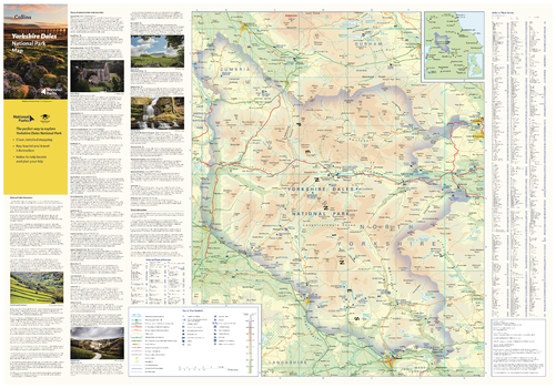
Yorkshire Dales National Park Map
With clear mapping and a high level of detail, explore Yorkshire Dales National Park easily with maps from Collins. This map identifies key park, tourist, and travel information, presented alongside a selection of photographs, making it an ideal companion for those exploring this beautiful area of Northern England.
Page Size: 32 x 22.25 in (810 x 560 mm)