


Backroad Mapbooks
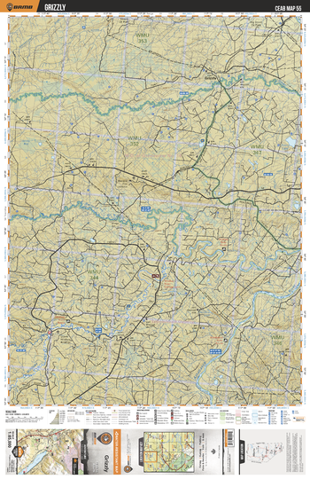
CEAB55 Grizzly - Central Alberta Topo
This recreation topographic map for Grizzly highlights all the logging and resource roads, multi-use trails for hikers, mountain bikers, horseback riders, cross-country skiers and snowshoers, motorized trails for ATVers and snowmobiles, fishing lakes and rivers, recreation areas, campgrounds, day-use areas, viewpoints, backcountry campsites, work camps, oil & gas sites, backcountry huts and cabins and more. No other map for the area provides you with this level of recreational or topographic detail. Covering 3,040 km2 (1,175 mi2) in total, this 1:85,000 scale map measures 48 x 63.5 km (30 x 39.5 mi). Special features include enhanced oil & gas data plus countless roads, trails and recreational Points of Interest. This map includes Athabasca River, Wildhay River, Berland River, Little Smoky River, Grizzly, Sides Lake, String Bog, Waskahigan River, Rainbow Lake and more!
Page Size: 24 x 37 in (610 x 940 mm)
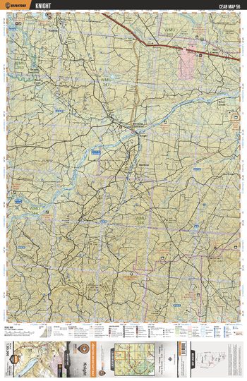
CEAB56 Knight - Central Alberta Topo
This recreation topographic map for Knight highlights all the logging and resource roads, multi-use trails for hikers, mountain bikers, horseback riders, cross-country skiers and snowshoers, motorized trails for ATVers and snowmobiles, fishing lakes and rivers, recreation areas, campgrounds, day-use areas, viewpoints, backcountry campsites, work camps, oil & gas sites, backcountry huts and cabins and more. No other map for the area provides you with this level of recreational or topographic detail. Covering 3,040 km2 (1,175 mi2) in total, this 1:85,000 scale map measures 48 x 63.5 km (30 x 39.5 mi). Special features include enhanced oil & gas data plus countless roads, trails and recreational Points of Interest. This map includes Grizzly Junction, Knight, Silver Creek, Two Creeks, Benbow Junction, Benbow, Berland River, Athabasca River, Clark Lake, Little Smoky River and more!
Page Size: 24 x 37 in (610 x 940 mm)
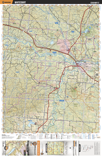
CEAB57 Whitecourt - Central Alberta Topo
This recreation topographic map for Whitecourt highlights all the logging and resource roads, multi-use trails for hikers, mountain bikers, horseback riders, cross-country skiers and snowshoers, motorized trails for ATVers and snowmobiles, fishing lakes and rivers, recreation areas, campgrounds, day-use areas, viewpoints, backcountry campsites, work camps, oil & gas sites, backcountry huts and cabins and more. No other map for the area provides you with this level of recreational or topographic detail. Covering 3,040 km2 (1,175 mi2) in total, this 1:85,000 scale map measures 48 x 63.5 km (30 x 39.5 mi). Special features include enhanced oil & gas data plus countless roads, trails and recreational Points of Interest. This map includes Whitecourt, Mahaska, Athabasca River, McLeod River, Sakwatamau River, McLeod Lake, Carson Pegasus Prov Park, House Mtn, Shiningbank Lake, Hurdy and more!
Page Size: 24 x 37 in (610 x 940 mm)
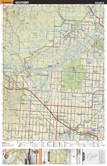
CEAB58 Mayerthorpe - Central Alberta Topo
This recreation topographic map for Mayerthorpe highlights all the logging and resource roads, multi-use trails for hikers, mountain bikers, horseback riders, cross-country skiers and snowshoers, motorized trails for ATVers and snowmobiles, fishing lakes and rivers, recreation areas, campgrounds, day-use areas, viewpoints, backcountry campsites, work camps, oil & gas sites, backcountry huts and cabins and more. No other map for the area provides you with this level of recreational or topographic detail. Covering 3,040 km2 (1,175 mi2) in total, this 1:85,000 scale map measures 48 x 63.5 km (30 x 39.5 mi). Special features include enhanced oil & gas data plus countless roads, trails and recreational Points of Interest. This map includes Athabasca River, Connor Creek, Mayerthorpe, Angudo, Goose Lake, Corbett Creek, Lonira, Blue Ridge, Holmes Crossing Sandhills Eco Reserve, Freeman River and more!
Page Size: 24 x 37 in (610 x 940 mm)
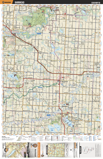
CEAB59 Barrhead - Central Alberta Topo
This recreation topographic map for Barrhead highlights all the logging and resource roads, multi-use trails for hikers, mountain bikers, horseback riders, cross-country skiers and snowshoers, motorized trails for ATVers and snowmobiles, fishing lakes and rivers, recreation areas, campgrounds, day-use areas, viewpoints, backcountry campsites, work camps, oil & gas sites, backcountry huts and cabins and more. No other map for the area provides you with this level of recreational or topographic detail. Covering 3,040 km2 (1,175 mi2) in total, this 1:85,000 scale map measures 48 x 63.5 km (30 x 39.5 mi). Special features include enhanced oil & gas data plus countless roads, trails and recreational Points of Interest. This map includes Fort Assiniboine Sandhills Wildland Prov Park, Lac la Nonne, Birch Cove, Thunder Lake, Athabasca River, Barrhead, Pembina River, Majeau Lake, Shoal Lake, Goodridge Lake and more!
Page Size: 24 x 37 in (610 x 940 mm)
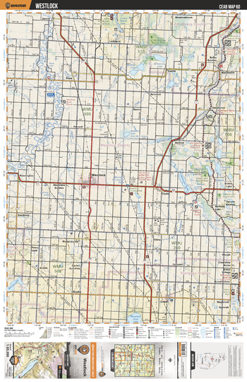
CEAB60 Westlock - Central Alberta Topo
This recreation topographic map for Westlock highlights all the logging and resource roads, multi-use trails for hikers, mountain bikers, horseback riders, cross-country skiers and snowshoers, motorized trails for ATVers and snowmobiles, fishing lakes and rivers, recreation areas, campgrounds, day-use areas, viewpoints, backcountry campsites, work camps, oil & gas sites, backcountry huts and cabins and more. No other map for the area provides you with this level of recreational or topographic detail. Covering 3,040 km2 (1,175 mi2) in total, this 1:85,000 scale map measures 48 x 63.5 km (30 x 39.5 mi). Special features include enhanced oil & gas data plus countless roads, trails and recreational Points of Interest. This map includes Pembina River, Westlock, Clyde, Rochester, Halfway Lake, Wakomao Lake, Bridge River, Lebeaus Lake, Armstrong Lake, Rossington and more!
Page Size: 24 x 37 in (610 x 940 mm)
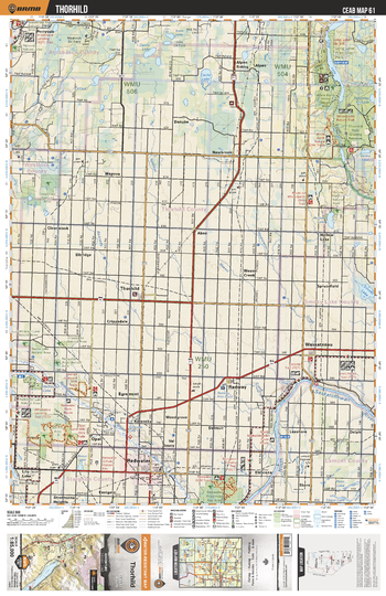
CEAB61 Thorhild - Central Alberta Topo
This recreation topographic map for Thorhild highlights all the logging and resource roads, multi-use trails for hikers, mountain bikers, horseback riders, cross-country skiers and snowshoers, motorized trails for ATVers and snowmobiles, fishing lakes and rivers, recreation areas, campgrounds, day-use areas, viewpoints, backcountry campsites, work camps, oil & gas sites, backcountry huts and cabins and more. No other map for the area provides you with this level of recreational or topographic detail. Covering 3,040 km2 (1,175 mi2) in total, this 1:85,000 scale map measures 48 x 63.5 km (30 x 39.5 mi). Special features include enhanced oil & gas data plus countless roads, trails and recreational Points of Interest. This map includes Thorhild, North Saskatchewan River, Thorhild Prov Grazing Reserve, White Earth Valley Natural Area, Long Lake, Newbrook, Waskatenau, Radway, Redwater, Redwater River and more!
Page Size: 24 x 37 in (610 x 940 mm)
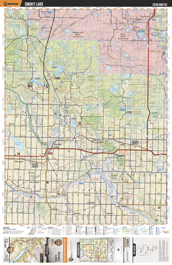
CEAB62 Smoky Lake - Central Alberta Topo
This recreation topographic map for Smoky Lake highlights all the logging and resource roads, multi-use trails for hikers, mountain bikers, horseback riders, cross-country skiers and snowshoers, motorized trails for ATVers and snowmobiles, fishing lakes and rivers, recreation areas, campgrounds, day-use areas, viewpoints, backcountry campsites, work camps, oil & gas sites, backcountry huts and cabins and more. No other map for the area provides you with this level of recreational or topographic detail. Covering 3,040 km2 (1,175 mi2) in total, this 1:85,000 scale map measures 48 x 63.5 km (30 x 39.5 mi). Special features include enhanced oil & gas data plus countless roads, trails and recreational Points of Interest. This map includes Smoky Lake, Bellis North Natural Area, North Saskatchewan River, White Earth Creek, Hanmore Lake, Lucky Lake, Thorhild Prov Grazing Reserve, Bellis, Wasel, Kikino and more!
Page Size: 24 x 37 in (610 x 940 mm)
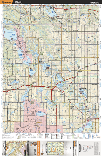
CEAB63 St Paul - Central Alberta Topo
This recreation topographic map for St Paul highlights all the logging and resource roads, multi-use trails for hikers, mountain bikers, horseback riders, cross-country skiers and snowshoers, motorized trails for ATVers and snowmobiles, fishing lakes and rivers, recreation areas, campgrounds, day-use areas, viewpoints, backcountry campsites, work camps, oil & gas sites, backcountry huts and cabins and more. No other map for the area provides you with this level of recreational or topographic detail. Covering 3,040 km2 (1,175 mi2) in total, this 1:85,000 scale map measures 48 x 63.5 km (30 x 39.5 mi). Special features include enhanced oil & gas data plus countless roads, trails and recreational Points of Interest. This map includes Whitefish Lake, Fork Lake, Vincent Lake, Vilna, Ashmont, Lottie Lake, Goodfish Lake, Garner Lake, St Paul, Mann Lakes and more!
Page Size: 24 x 37 in (610 x 940 mm)
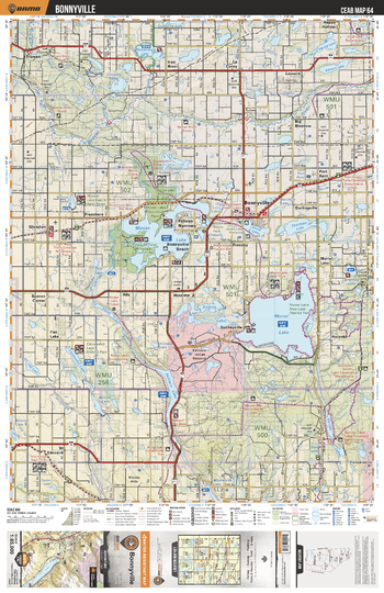
CEAB64 Bonnyville - Central Alberta Topo
This recreation topographic map for Bonnyville highlights all the logging and resource roads, multi-use trails for hikers, mountain bikers, horseback riders, cross-country skiers and snowshoers, motorized trails for ATVers and snowmobiles, fishing lakes and rivers, recreation areas, campgrounds, day-use areas, viewpoints, backcountry campsites, work camps, oil & gas sites, backcountry huts and cabins and more. No other map for the area provides you with this level of recreational or topographic detail. Covering 3,040 km2 (1,175 mi2) in total, this 1:85,000 scale map measures 48 x 63.5 km (30 x 39.5 mi). Special features include enhanced oil & gas data plus countless roads, trails and recreational Points of Interest. This map includes Muriel Lake, Moose Lake, Sinking Lake, Kehwin Lake, Bonnyville, Holyoke, Lessard, Iron River, Franchere, Glendon and more!
Page Size: 24 x 37 in (610 x 940 mm)
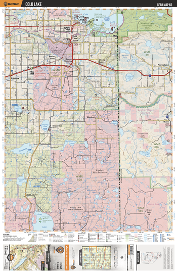
CEAB65 Cold Lake - Central Alberta Topo
This recreation topographic map for Cold Lake highlights all the logging and resource roads, multi-use trails for hikers, mountain bikers, horseback riders, cross-country skiers and snowshoers, motorized trails for ATVers and snowmobiles, fishing lakes and rivers, recreation areas, campgrounds, day-use areas, viewpoints, backcountry campsites, work camps, oil & gas sites, backcountry huts and cabins and more. No other map for the area provides you with this level of recreational or topographic detail. Covering 3,040 km2 (1,175 mi2) in total, this 1:85,000 scale map measures 48 x 63.5 km (30 x 39.5 mi). Special features include enhanced oil & gas data plus countless roads, trails and recreational Points of Interest. This map includes Cold Lake, Grand Centre, Ardmore, Elizabeth, Frog Lake, Reita Lake, Angling Lake, Cherry Cove, Thompson Lakes, Beaver River and more!
Page Size: 24 x 37 in (610 x 940 mm)
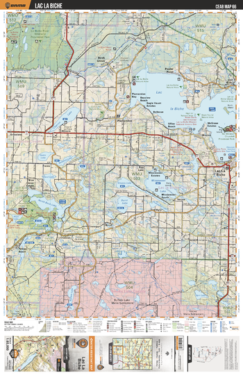
CEAB66 Lac La Biche - Central Alberta Topo
This recreation topographic map for Lac La Biche highlights all the logging and resource roads, multi-use trails for hikers, mountain bikers, horseback riders, cross-country skiers and snowshoers, motorized trails for ATVers and snowmobiles, fishing lakes and rivers, recreation areas, campgrounds, day-use areas, viewpoints, backcountry campsites, work camps, oil & gas sites, backcountry huts and cabins and more. No other map for the area provides you with this level of recreational or topographic detail. Covering 3,040 km2 (1,175 mi2) in total, this 1:85,000 scale map measures 48 x 63.5 km (30 x 39.5 mi). Special features include enhanced oil & gas data plus countless roads, trails and recreational Points of Interest. This map includes Lac la Biche, Missawawi Lake, Burnt Lake, North Buck Lake, Charron Lake, Lac la Biche River Wildland Prov Park, Buffalo Lake, Venice, Hylo, Caslan and more!
Page Size: 24 x 37 in (610 x 940 mm)
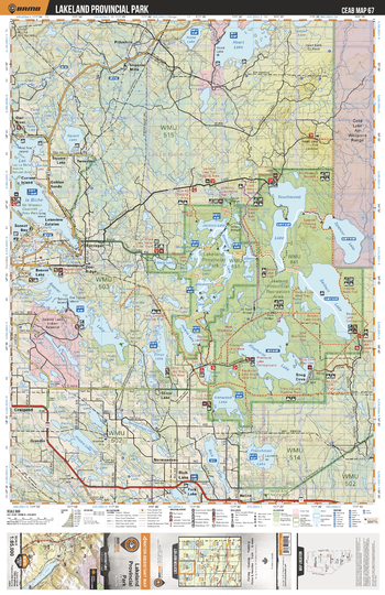
CEAB67 Lakeland Provincial Park - Central Alberta Topo
This recreation topographic map for Lakeland Provincial Park highlights all the logging and resource roads, multi-use trails for hikers, mountain bikers, horseback riders, cross-country skiers and snowshoers, motorized trails for ATVers and snowmobiles, fishing lakes and rivers, recreation areas, campgrounds, day-use areas, viewpoints, backcountry campsites, work camps, oil & gas sites, backcountry huts and cabins and more. No other map for the area provides you with this level of recreational or topographic detail. Covering 3,040 km2 (1,175 mi2) in total, this 1:85,000 scale map measures 48 x 63.5 km (30 x 39.5 mi). Special features include enhanced oil & gas data plus countless roads, trails and recreational Points of Interest. This map includes Lakeland Prov Park, Seibert Lake, Touchwood Lake, Beaver Lake, Lac la Biche, Square Lake, Heart Lake, Elinor Lake, Ironwood Lake, Pinehurst Lake and more!
Page Size: 24 x 37 in (610 x 940 mm)
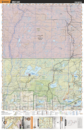
CEAB68 Wolf Lake - Central Alberta Topo
This recreation topographic map for Wolf Lake highlights all the logging and resource roads, multi-use trails for hikers, mountain bikers, horseback riders, cross-country skiers and snowshoers, motorized trails for ATVers and snowmobiles, fishing lakes and rivers, recreation areas, campgrounds, day-use areas, viewpoints, backcountry campsites, work camps, oil & gas sites, backcountry huts and cabins and more. No other map for the area provides you with this level of recreational or topographic detail. Covering 3,040 km2 (1,175 mi2) in total, this 1:85,000 scale map measures 48 x 63.5 km (30 x 39.5 mi). Special features include enhanced oil & gas data plus countless roads, trails and recreational Points of Interest. This map includes Wolf Lake, Marguerite Lake, Crane Lake, Sand River, Lane Lake, Barbara Lake, Tucker Lake, Osborne Lake, Bourque Lake, Sinclair Lake and more!
Page Size: 24 x 37 in (610 x 940 mm)
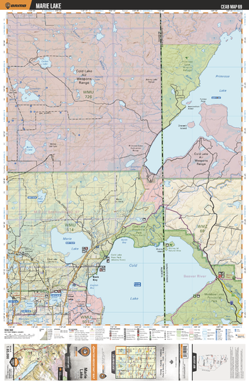
CEAB69 Ethel Lake - Central Alberta Topo
This recreation topographic map for Ethel Lake highlights all the logging and resource roads, multi-use trails for hikers, mountain bikers, horseback riders, cross-country skiers and snowshoers, motorized trails for ATVers and snowmobiles, fishing lakes and rivers, recreation areas, campgrounds, day-use areas, viewpoints, backcountry campsites, work camps, oil & gas sites, backcountry huts and cabins and more. No other map for the area provides you with this level of recreational or topographic detail. Covering 3,040 km2 (1,175 mi2) in total, this 1:85,000 scale map measures 48 x 63.5 km (30 x 39.5 mi). Special features include enhanced oil & gas data plus countless roads, trails and recreational Points of Interest. This map includes Primrose Lake, Marie Lake, Cold Lake, Bank Bay, Cold Lake Prov Park (North Shore), Martineau River, Ethel Lake, Hilda Lake, May Lake, Stouffers Lake and more!
Page Size: 24 x 37 in (610 x 940 mm)
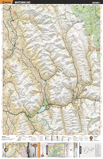
CRCR01 Whiteswan Lake - Canadian Rockies Topo
This recreation topographic map for Whiteswan Lake highlights all the roads, fishing lakes & streams, front and backcountry campsites, paddling routes for canoeing and kayaking, wildlife viewing areas, multi-use trails for hiking, backcountry skiing, snowshoeing, mountain biking, horseback riding & more. Covering 1,950 km2 (753 mi2), this map measures 38 x 51 km (24 x 32 mi), providing you with more topographic and recreational detail for the Whiteswan Lake area than any other map on the market. Special features include private land and countless roads, trails and recreational Points of Interest. Included on this map are Whiteswan Lake, Whiteswan Lake Provincial Park, Height of the Rockies Prov Park, North White River, White River and more!
Page Size: 24 x 37 in (610 x 940 mm)
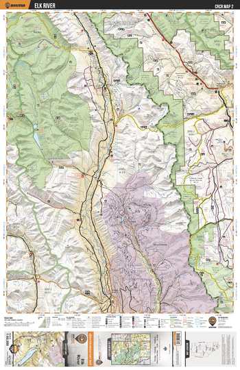
CRCR02 Elk River - Canadian Rockies Topo
This recreation topographic map for Elk River highlights all the roads, fishing lakes & streams, front and backcountry campsites, paddling routes for canoeing and kayaking, wildlife viewing areas, multi-use trails for hiking, backcountry skiing, snowshoeing, mountain biking, horseback riding & more. Covering 1,950 km2 (753 mi2), this map measures 38 x 51 km (24 x 32 mi), providing you with more topographic and recreational detail for the Whiteswan Lake area than any other map on the market. Special features include private land and countless roads, trails and recreational Points of Interest. Included on this map are Elk River, Elk Lakes Prov Park, Don Getty Wildland Provincial Park, Connor Lakes, Height of the Rockies Provincial Park, Elbow Sheep Wildland Provincial Park and more!
Page Size: 24 x 37 in (610 x 940 mm)
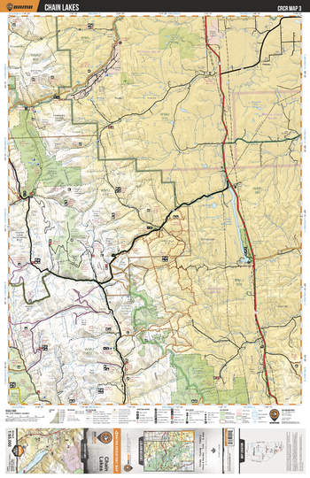
CRCR03 Chain Lakes - Canadian Rockies Topo
This recreation topographic map for Chain Lakes highlights all the roads, fishing lakes & streams, front and backcountry campsites, paddling routes for canoeing and kayaking, wildlife viewing areas, multi-use trails for hiking, backcountry skiing, snowshoeing, mountain biking, horseback riding & more. Covering 1,950 km2 (753 mi2), this map measures 38 x 51 km (24 x 32 mi), providing you with more topographic and recreational detail for the Whiteswan Lake area than any other map on the market. Special features include private land and countless roads, trails and recreational Points of Interest. Included on this map are Chain Lakes, Highwood River, OH Ranch Heritage Rangeland, Emerson Creek Natural Area, Don Getty Wildland Provincial Park, Mt Livingston Natural Area, Bob Creek Wildland Provincial Park and more!
Page Size: 24 x 37 in (610 x 940 mm)
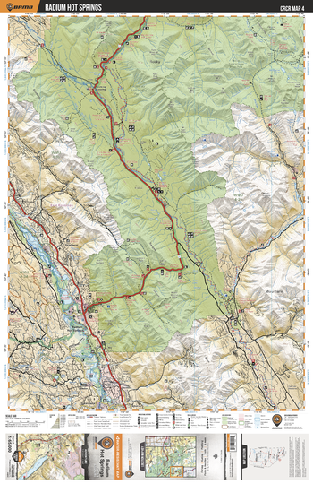
CRCR04 Radium Hot Springs - Canadian Rockies Topo
This recreation topographic map for Radium Hot Springs highlights all the roads, fishing lakes & streams, front and backcountry campsites, paddling routes for canoeing and kayaking, wildlife viewing areas, multi-use trails for hiking, backcountry skiing, snowshoeing, mountain biking, horseback riding & more. Covering 1,950 km2 (753 mi2), this map measures 38 x 51 km (24 x 32 mi), providing you with more topographic and recreational detail for the Whiteswan Lake area than any other map on the market. Special features include private land and countless roads, trails and recreational Points of Interest. Included on this map are Radium Hot Springs, Kootenay National Park, Vermillion River, Kootenay River, Columbia River, Dry Gulch Provincial Park, Cross River, Mitchell River and more!
Page Size: 24 x 37 in (610 x 940 mm)
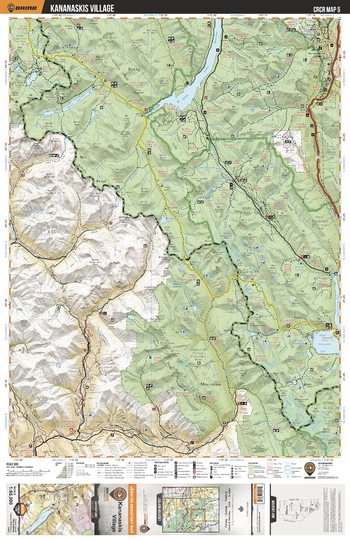
CRCR05 Kananaskis Village - Canadian Rockies Topo
This recreation topographic map for Kananaskis Village highlights all the roads, fishing lakes & streams, front and backcountry campsites, paddling routes for canoeing and kayaking, wildlife viewing areas, multi-use trails for hiking, backcountry skiing, snowshoeing, mountain biking, horseback riding & more. Covering 1,950 km2 (753 mi2), this map measures 38 x 51 km (24 x 32 mi), providing you with more topographic and recreational detail for the Whiteswan Lake area than any other map on the market. Special features include private land and countless roads, trails and recreational Points of Interest. Included on this map are Kananaskis Village, Banff National Park, Spray Lakes Reservior, Marvel Lake, Height of the Rockies Provincial Park, Peter Lougheed Provincial park, Upper Kananaskis Lake and more!
Page Size: 24 x 37 in (610 x 940 mm)