


Backroad Mapbooks
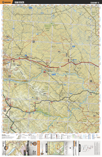
CEAB15 Ram River - Central Alberta Topo
This recreation topographic map for Ram River highlights all the logging and resource roads, multi-use trails for hikers, mountain bikers, horseback riders, cross-country skiers and snowshoers, motorized trails for ATVers and snowmobiles, fishing lakes and rivers, recreation areas, campgrounds, day-use areas, viewpoints, backcountry campsites, work camps, oil & gas sites, backcountry huts and cabins and more. No other map for the area provides you with this level of recreational or topographic detail. Covering 3,040 km2 (1,175 mi2) in total, this 1:85,000 scale map measures 48 x 63.5 km (30 x 39.5 mi). Special features include enhanced oil & gas data plus countless roads, trails and recreational Points of Interest. This map includes North Saskatchewan River, Nordegg, McGregor Lake, North Ram River, Jock Lake, Baptiste River, Jackfish Lake, Harlech, Chambers Creek, Saunders and more!
Page Size: 24 x 37 in (610 x 940 mm)
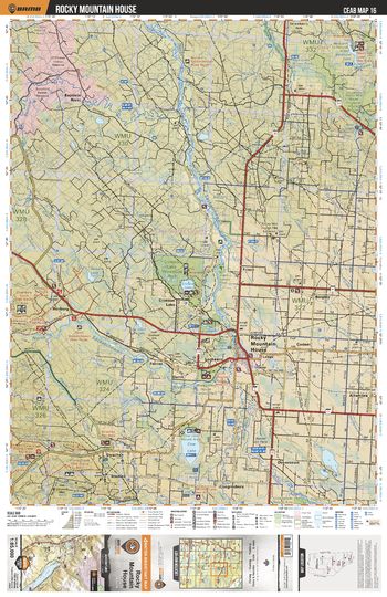
CEAB16 Rocky Mountain House - Central Alberta Topo
This recreation topographic map for Rocky Mountain House highlights all the logging and resource roads, multi-use trails for hikers, mountain bikers, horseback riders, cross-country skiers and snowshoers, motorized trails for ATVers and snowmobiles, fishing lakes and rivers, recreation areas, campgrounds, day-use areas, viewpoints, backcountry campsites, work camps, oil & gas sites, backcountry huts and cabins and more. No other map for the area provides you with this level of recreational or topographic detail. Covering 3,040 km2 (1,175 mi2) in total, this 1:85,000 scale map measures 48 x 63.5 km (30 x 39.5 mi). Special features include enhanced oil & gas data plus countless roads, trails and recreational Points of Interest. This map includes Rocky Mountain House, Crimson Lake, Cow Lake, Medicine Lake, Dovercourt, Strachan, North Saskatchewan River, Ferrier, Horburg, Baptiste River and more!
Page Size: 24 x 37 in (610 x 940 mm)
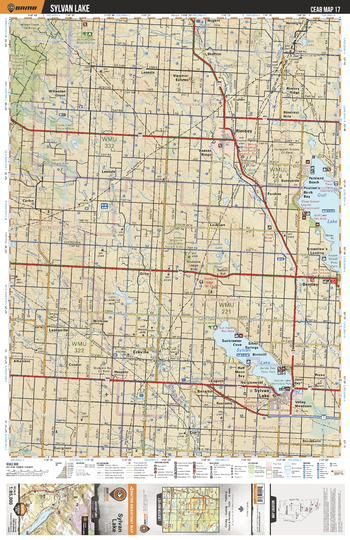
CEAB17 Sylvan Lake - Central Alberta Topo
This recreation topographic map for Sylvan Lake highlights all the logging and resource roads, multi-use trails for hikers, mountain bikers, horseback riders, cross-country skiers and snowshoers, motorized trails for ATVers and snowmobiles, fishing lakes and rivers, recreation areas, campgrounds, day-use areas, viewpoints, backcountry campsites, work camps, oil & gas sites, backcountry huts and cabins and more. No other map for the area provides you with this level of recreational or topographic detail. Covering 3,040 km2 (1,175 mi2) in total, this 1:85,000 scale map measures 48 x 63.5 km (30 x 39.5 mi). Special features include enhanced oil & gas data plus countless roads, trails and recreational Points of Interest. This map includes Gull Lake, Sylvan Lake, Jarvis Bay, Parkland Beach, Bluffton, Willesden Green, Gilby, Leslieville, Stockholm, Prevo and more!
Page Size: 24 x 37 in (610 x 940 mm)
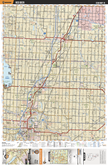
CEAB18 Red Deer - Central Alberta Topo
This recreation topographic map for Red Deer highlights all the logging and resource roads, multi-use trails for hikers, mountain bikers, horseback riders, cross-country skiers and snowshoers, motorized trails for ATVers and snowmobiles, fishing lakes and rivers, recreation areas, campgrounds, day-use areas, viewpoints, backcountry campsites, work camps, oil & gas sites, backcountry huts and cabins and more. No other map for the area provides you with this level of recreational or topographic detail. Covering 3,040 km2 (1,175 mi2) in total, this 1:85,000 scale map measures 48 x 63.5 km (30 x 39.5 mi). Special features include enhanced oil & gas data plus countless roads, trails and recreational Points of Interest. This map includes Gull Lake, Red Deer, Blackfalds, Lacombe, Morningside, Ponoka, Battle River, Red Deer River, Clive, Tees and more!
Page Size: 24 x 37 in (610 x 940 mm)
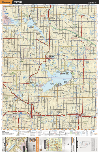
CEAB19 Stettler - Central Alberta Topo
This recreation topographic map for Stettler highlights all the logging and resource roads, multi-use trails for hikers, mountain bikers, horseback riders, cross-country skiers and snowshoers, motorized trails for ATVers and snowmobiles, fishing lakes and rivers, recreation areas, campgrounds, day-use areas, viewpoints, backcountry campsites, work camps, oil & gas sites, backcountry huts and cabins and more. No other map for the area provides you with this level of recreational or topographic detail. Covering 3,040 km2 (1,175 mi2) in total, this 1:85,000 scale map measures 48 x 63.5 km (30 x 39.5 mi). Special features include enhanced oil & gas data plus countless roads, trails and recreational Points of Interest. This map includes Buffalo Lake, Red Deer Lake, Mirror, Stettler, Rochon Sands, Alix Lake, Erskine, Red Deer River, Meeting Creek, Ferintosh and more!
Page Size: 24 x 37 in (610 x 940 mm)
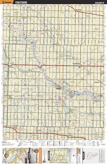
CEAB20 Forestburg - Central Alberta Topo
This recreation topographic map for Forestburg highlights all the logging and resource roads, multi-use trails for hikers, mountain bikers, horseback riders, cross-country skiers and snowshoers, motorized trails for ATVers and snowmobiles, fishing lakes and rivers, recreation areas, campgrounds, day-use areas, viewpoints, backcountry campsites, work camps, oil & gas sites, backcountry huts and cabins and more. No other map for the area provides you with this level of recreational or topographic detail. Covering 3,040 km2 (1,175 mi2) in total, this 1:85,000 scale map measures 48 x 63.5 km (30 x 39.5 mi). Special features include enhanced oil & gas data plus countless roads, trails and recreational Points of Interest. This map includes Battle River, Forestburg, Big Knife Prov Park, Paintearth Badlands, Halkirk, Botha, Gadsby, Galahad, Red Willow, Rosalind and more!
Page Size: 24 x 37 in (610 x 940 mm)
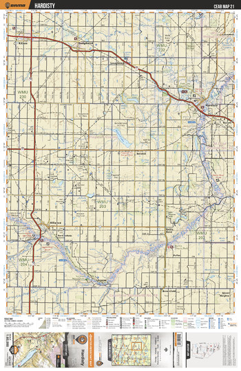
CEAB21 Hardisty - Central Alberta Topo
This recreation topographic map for Hardisty highlights all the logging and resource roads, multi-use trails for hikers, mountain bikers, horseback riders, cross-country skiers and snowshoers, motorized trails for ATVers and snowmobiles, fishing lakes and rivers, recreation areas, campgrounds, day-use areas, viewpoints, backcountry campsites, work camps, oil & gas sites, backcountry huts and cabins and more. No other map for the area provides you with this level of recreational or topographic detail. Covering 3,040 km2 (1,175 mi2) in total, this 1:85,000 scale map measures 48 x 63.5 km (30 x 39.5 mi). Special features include enhanced oil & gas data plus countless roads, trails and recreational Points of Interest. This map includes Hardisty, Alliance, Sedgewick, Lougheed, Rosyth, Brownfield, Bellshill, Battle River, Fish Lake, Killam and more!
Page Size: 24 x 37 in (610 x 940 mm)
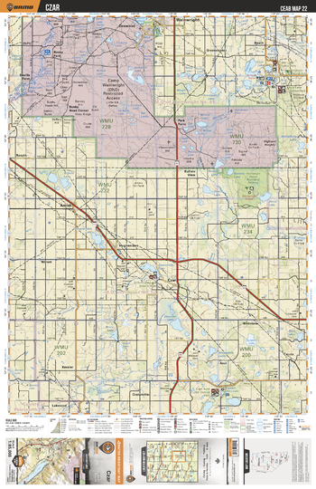
CEAB22 Czar - Central Alberta Topo
This recreation topographic map for Czar highlights all the logging and resource roads, multi-use trails for hikers, mountain bikers, horseback riders, cross-country skiers and snowshoers, motorized trails for ATVers and snowmobiles, fishing lakes and rivers, recreation areas, campgrounds, day-use areas, viewpoints, backcountry campsites, work camps, oil & gas sites, backcountry huts and cabins and more. No other map for the area provides you with this level of recreational or topographic detail. Covering 3,040 km2 (1,175 mi2) in total, this 1:85,000 scale map measures 48 x 63.5 km (30 x 39.5 mi). Special features include enhanced oil & gas data plus countless roads, trails and recreational Points of Interest. This map includes Houcher Lake, Hughenden, Amisk, Czar, Buffalo View, Park Farm, Bushy Head Corner, Shorncliffe Lake, Asul, Captain Ayre Lake and more!
Page Size: 24 x 37 in (610 x 940 mm)
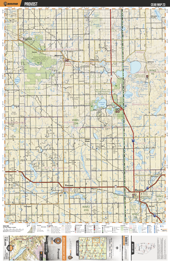
CEAB23 Provost - Central Alberta Topo
This recreation topographic map for Provost highlights all the logging and resource roads, multi-use trails for hikers, mountain bikers, horseback riders, cross-country skiers and snowshoers, motorized trails for ATVers and snowmobiles, fishing lakes and rivers, recreation areas, campgrounds, day-use areas, viewpoints, backcountry campsites, work camps, oil & gas sites, backcountry huts and cabins and more. No other map for the area provides you with this level of recreational or topographic detail. Covering 3,040 km2 (1,175 mi2) in total, this 1:85,000 scale map measures 48 x 63.5 km (30 x 39.5 mi). Special features include enhanced oil & gas data plus countless roads, trails and recreational Points of Interest. This map includes Killarney Lake, Reflex Lakes, Ribstone, Provost, Macklin, Chauvin, Dunn, Edgerton, Artland, Green Glade and more!
Page Size: 24 x 37 in (610 x 940 mm)
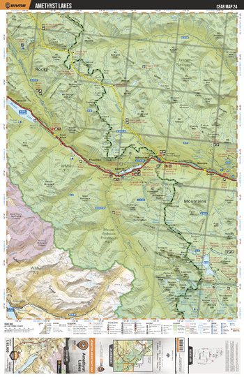
CEAB24 Amethyst Lakes - Central Alberta Topo
This recreation topographic map for Amethyst Lakes highlights all the logging and resource roads, multi-use trails for hikers, mountain bikers, horseback riders, cross-country skiers and snowshoers, motorized trails for ATVers and snowmobiles, fishing lakes and rivers, recreation areas, campgrounds, day-use areas, viewpoints, backcountry campsites, work camps, oil & gas sites, backcountry huts and cabins and more. No other map for the area provides you with this level of recreational or topographic detail. Covering 3,040 km2 (1,175 mi2) in total, this 1:85,000 scale map measures 48 x 63.5 km (30 x 39.5 mi). Special features include enhanced oil & gas data plus countless roads, trails and recreational Points of Interest. This map includes Amethyst Lakes, Mount Robson Provincial Park, Jasper National Park, Moose Lake, Kinbasket Lake, Yellowhead Lake, Snaring River and more!
Page Size: 24 x 37 in (610 x 940 mm)
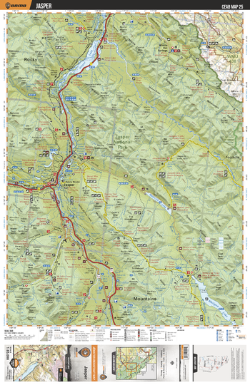
CEAB25 Jasper - Central Alberta Topo
This recreation topographic map for Jasper highlights all the logging and resource roads, multi-use trails for hikers, mountain bikers, horseback riders, cross-country skiers and snowshoers, motorized trails for ATVers and snowmobiles, fishing lakes and rivers, recreation areas, campgrounds, day-use areas, viewpoints, backcountry campsites, work camps, oil & gas sites, backcountry huts and cabins and more. No other map for the area provides you with this level of recreational or topographic detail. Covering 3,040 km2 (1,175 mi2) in total, this 1:85,000 scale map measures 48 x 63.5 km (30 x 39.5 mi). Special features include enhanced oil & gas data plus countless roads, trails and recreational Points of Interest. This map includes Jasper, Jasper National Park, Whitehorse Wildland Provincial Park, Jasper Lake, Athabasca River, Rocky River, Medicine Lake and more!
Page Size: 24 x 37 in (610 x 940 mm)
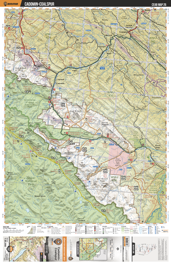
CEAB26 Cadomin-Coalspur - Central Alberta Topo
This recreation topographic map for Cadomin-Coalspur highlights all the logging and resource roads, multi-use trails for hikers, mountain bikers, horseback riders, cross-country skiers and snowshoers, motorized trails for ATVers and snowmobiles, fishing lakes and rivers, recreation areas, campgrounds, day-use areas, viewpoints, backcountry campsites, work camps, oil & gas sites, backcountry huts and cabins and more. No other map for the area provides you with this level of recreational or topographic detail. Covering 3,040 km2 (1,175 mi2) in total, this 1:85,000 scale map measures 48 x 63.5 km (30 x 39.5 mi). Special features include enhanced oil & gas data plus countless roads, trails and recreational Points of Interest. This map includes Jasper National Park, Whitehorse Wildland Prov Park, McLeod River, Brazeau River, Medicine Tent River, Grave Flats, Cadomin, Coalspur, Cardinal River, Fidler and more!
Page Size: 24 x 37 in (610 x 940 mm)
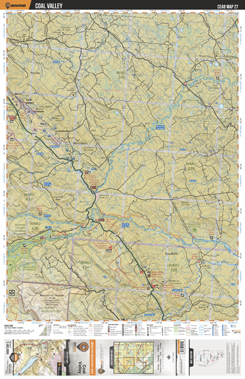
CEAB27 Coal Valley - Central Alberta Topo
This recreation topographic map for Coal Valley highlights all the logging and resource roads, multi-use trails for hikers, mountain bikers, horseback riders, cross-country skiers and snowshoers, motorized trails for ATVers and snowmobiles, fishing lakes and rivers, recreation areas, campgrounds, day-use areas, viewpoints, backcountry campsites, work camps, oil & gas sites, backcountry huts and cabins and more. No other map for the area provides you with this level of recreational or topographic detail. Covering 3,040 km2 (1,175 mi2) in total, this 1:85,000 scale map measures 48 x 63.5 km (30 x 39.5 mi). Special features include enhanced oil & gas data plus countless roads, trails and recreational Points of Interest. This map includes Pembina River, Brazeau River, Blackstone River, Fairfax Lake, Lovettville, Reco, Foothills, Coal Valley, Sterco, Cardinal River and more!
Page Size: 24 x 37 in (610 x 940 mm)
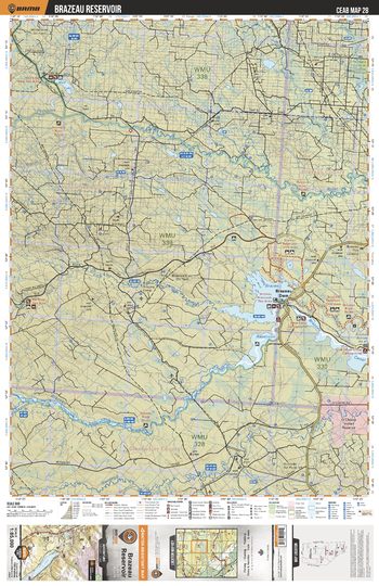
CEAB28 Brazeau Reservoir - Central Alberta Topo
This recreation topographic map for Brazeau Reservoir highlights all the logging and resource roads, multi-use trails for hikers, mountain bikers, horseback riders, cross-country skiers and snowshoers, motorized trails for ATVers and snowmobiles, fishing lakes and rivers, recreation areas, campgrounds, day-use areas, viewpoints, backcountry campsites, work camps, oil & gas sites, backcountry huts and cabins and more. No other map for the area provides you with this level of recreational or topographic detail. Covering 3,040 km2 (1,175 mi2) in total, this 1:85,000 scale map measures 48 x 63.5 km (30 x 39.5 mi). Special features include enhanced oil & gas data plus countless roads, trails and recreational Points of Interest. This map includes Brazeau Reservoir, Brazeau Canal, Brazeau River, Pembina River, Wolf Lake, Brazeau Dam, Nordegg River, Elk River and more!
Page Size: 24 x 37 in (610 x 940 mm)
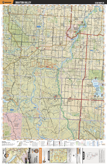
CEAB29 Drayton Valley - Central Alberta Topo
This recreation topographic map for Drayton Valley highlights all the logging and resource roads, multi-use trails for hikers, mountain bikers, horseback riders, cross-country skiers and snowshoers, motorized trails for ATVers and snowmobiles, fishing lakes and rivers, recreation areas, campgrounds, day-use areas, viewpoints, backcountry campsites, work camps, oil & gas sites, backcountry huts and cabins and more. No other map for the area provides you with this level of recreational or topographic detail. Covering 3,040 km2 (1,175 mi2) in total, this 1:85,000 scale map measures 48 x 63.5 km (30 x 39.5 mi). Special features include enhanced oil & gas data plus countless roads, trails and recreational Points of Interest. This map includes Buck Lake, Alder Flats, Brazeau River, North Saskatchewan River, Drayton Valley, Eagle Point Prov Park, Pembina River, Pembina Grazing Reserve, Lodgepole, Pembina and more!
Page Size: 24 x 37 in (610 x 940 mm)
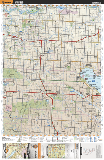
CEAB30 Winfield - Central Alberta Topo
This recreation topographic map for Winfield highlights all the logging and resource roads, multi-use trails for hikers, mountain bikers, horseback riders, cross-country skiers and snowshoers, motorized trails for ATVers and snowmobiles, fishing lakes and rivers, recreation areas, campgrounds, day-use areas, viewpoints, backcountry campsites, work camps, oil & gas sites, backcountry huts and cabins and more. No other map for the area provides you with this level of recreational or topographic detail. Covering 3,040 km2 (1,175 mi2) in total, this 1:85,000 scale map measures 48 x 63.5 km (30 x 39.5 mi). Special features include enhanced oil & gas data plus countless roads, trails and recreational Points of Interest. This map includes Pigeon Lake, Buck Mountain Grazing Reserve, Town Lake, Thorsby, Benton, Coyote Lake Natural Area, Lindale, Warburg, Battle Lake, Twin Lakes and more!
Page Size: 24 x 37 in (610 x 940 mm)
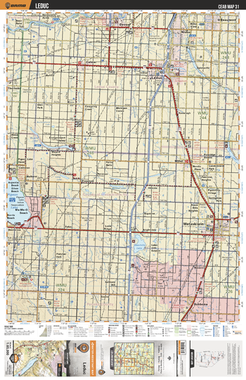
CEAB31 Leduc - Central Alberta Topo
This recreation topographic map for Leduc highlights all the logging and resource roads, multi-use trails for hikers, mountain bikers, horseback riders, cross-country skiers and snowshoers, motorized trails for ATVers and snowmobiles, fishing lakes and rivers, recreation areas, campgrounds, day-use areas, viewpoints, backcountry campsites, work camps, oil & gas sites, backcountry huts and cabins and more. No other map for the area provides you with this level of recreational or topographic detail. Covering 3,040 km2 (1,175 mi2) in total, this 1:85,000 scale map measures 48 x 63.5 km (30 x 39.5 mi). Special features include enhanced oil & gas data plus countless roads, trails and recreational Points of Interest. This map includes Pigeon Lake, Bearhills Lake, Wizard Lake, Saunders Lake, Coal Lake, Wetaskiwin, Hobbema, Leduc, Nisku, Devon and more!
Page Size: 24 x 37 in (610 x 940 mm)
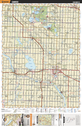
CEAB32 Camrose - Central Alberta Topo
This recreation topographic map for Camrose highlights all the logging and resource roads, multi-use trails for hikers, mountain bikers, horseback riders, cross-country skiers and snowshoers, motorized trails for ATVers and snowmobiles, fishing lakes and rivers, recreation areas, campgrounds, day-use areas, viewpoints, backcountry campsites, work camps, oil & gas sites, backcountry huts and cabins and more. No other map for the area provides you with this level of recreational or topographic detail. Covering 3,040 km2 (1,175 mi2) in total, this 1:85,000 scale map measures 48 x 63.5 km (30 x 39.5 mi). Special features include enhanced oil & gas data plus countless roads, trails and recreational Points of Interest. This map includes Bittern Lake, Driedmeat Lake, Coal Lake, Battle River, Miquelon Lakes, Joseph Lake, Tofield, Camrose, New Norway, Hay Lakes and more!
Page Size: 24 x 37 in (610 x 940 mm)
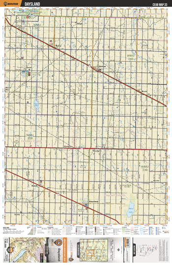
CEAB33 Daysland - Central Alberta Topo
This recreation topographic map for Daysland highlights all the logging and resource roads, multi-use trails for hikers, mountain bikers, horseback riders, cross-country skiers and snowshoers, motorized trails for ATVers and snowmobiles, fishing lakes and rivers, recreation areas, campgrounds, day-use areas, viewpoints, backcountry campsites, work camps, oil & gas sites, backcountry huts and cabins and more. No other map for the area provides you with this level of recreational or topographic detail. Covering 3,040 km2 (1,175 mi2) in total, this 1:85,000 scale map measures 48 x 63.5 km (30 x 39.5 mi). Special features include enhanced oil & gas data plus countless roads, trails and recreational Points of Interest. This map includes Daysland, Bawlf, Holden, Ryley, Bruce, Shonts, Dodds, Black Nugget Lake Country Park, Gladstone, Woodglen, Wavy Lake and more!
Page Size: 24 x 37 in (610 x 940 mm)
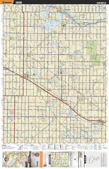
CEAB34 Viking - Central Alberta Topo
This recreation topographic map for Viking highlights all the logging and resource roads, multi-use trails for hikers, mountain bikers, horseback riders, cross-country skiers and snowshoers, motorized trails for ATVers and snowmobiles, fishing lakes and rivers, recreation areas, campgrounds, day-use areas, viewpoints, backcountry campsites, work camps, oil & gas sites, backcountry huts and cabins and more. No other map for the area provides you with this level of recreational or topographic detail. Covering 3,040 km2 (1,175 mi2) in total, this 1:85,000 scale map measures 48 x 63.5 km (30 x 39.5 mi). Special features include enhanced oil & gas data plus countless roads, trails and recreational Points of Interest. This map includes Vernon Lake, Kinsella, Viking, Birch Lake, Thomas Lake, Hattie Lake, Irma, Minburn, Alice Lake, Camp Lake and more!
Page Size: 24 x 37 in (610 x 940 mm)