


MapSherpa Catalog
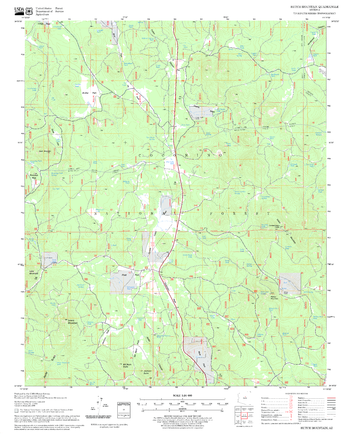
Hutch Mountain Quadrangle, Arizona
United States Department of Agriculture Forest Service
United States Department of Agriculture Forestry Service topographical map of Hutch Mountain, Coconino National Forest, Arizona.
Page Size: 21.75 x 27 in (552 x 686 mm)
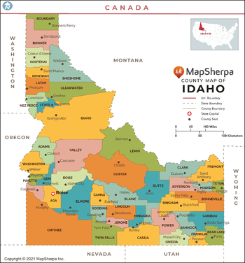
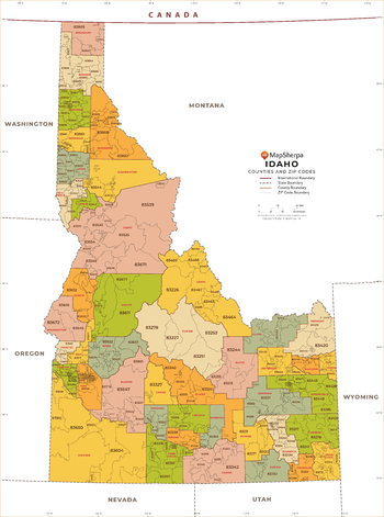
Idaho Counties Map - Extra Large
MapSherpa
This map has been created exclusively for MapSherpa, and designed for reference or business use. Clear and clean colors & fonts matched with cartographic research makes this map of Idaho Counties Map easily readable and useful. The map shows the 44 counties of Idaho and their borders across the Gem State.
Page Size: 60 x 64.5 in (1524 x 1636 mm)

Idaho Counties Map - Large
MapSherpa
This map has been created exclusively for MapSherpa, and designed for reference or business use. Clear and clean colors & fonts matched with cartographic research makes this map of Idaho Counties Map easily readable and useful. The map shows the 44 counties of Idaho and their borders across the Gem State.
Page Size: 48 x 51.75 in (1219 x 1308 mm)

Idaho Counties Map - Standard
MapSherpa
This map has been created exclusively for MapSherpa, and designed for reference or business use. Clear and clean colors & fonts matched with cartographic research makes this map of Idaho Counties Map easily readable and useful. The map shows the 44 counties of Idaho and their borders across the Gem State.
Page Size: 36 x 38.75 in (914 x 981 mm)
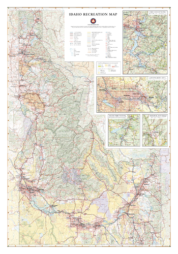
Idaho Recreation Wall Map – 26 inch
Benchmark Maps
Idaho’s abundance of rare minerals, including the rare Star Garnet, earns it the nickname “The Gem State”. Idaho also boasts a wealth of mountain recreation and public lands including Craters of the Moon, Hells Canyon, the Sawtooth Mountains, and the western flanks of Yellowstone & Grand Teton National Parks. This wall map illustrates all the full state plus inset maps of Lake Coeur d’Alene, Boise, Island Park, and Ketchum-Sun Valley.
Page Size: 26 x 37.25 in (660 x 943 mm)
Idaho State Wall Map
Globe Turner
This colorful, easy-to-read state map of Idaho identifies all major thoroughfares, secondary roads, freeway interchanges, rest areas, distance markers, landmarks, recreational areas, and more. Shaded relief on the state map provides a three-dimensional sense of Idaho’s topography. Detailed inset maps of Boise, Idaho Falls, and Pocatello are based on the latest street information from our cartographic experts. County and city indices make it simple to locate even the smallest town. City type sizes reflect the 2020 U.S. Census.
Page Size: 14.75 x 17.75 in (375 x 451 mm)
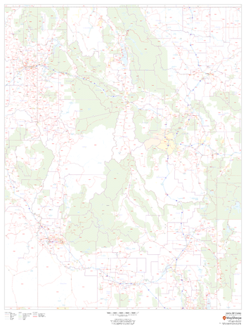
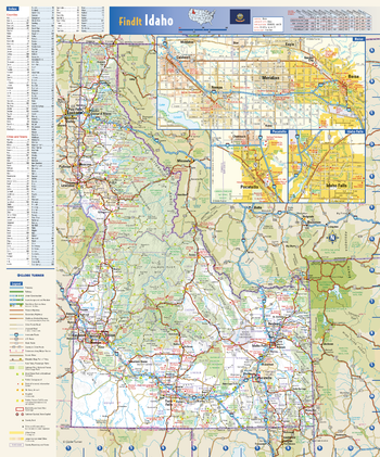
Idaho ZIP Code Map
MapSherpa
This map of Idaho shows ZIP codes overlaid on a road map. Base map features include county boundaries, major road network features, and state and national parks and conservation areas.
Page Size: 36 x 48 in (914 x 1219 mm)

Idaho ZIP Code Map with Counties - Extra Large
MapSherpa
This map has been created exclusively for MapSherpa, and designed for business or reference use. Clear and clean colors & fonts matched with cartographic research makes this Idaho Zip Code Map with Counties easily readable and useful. The map shows the 44 counties of Idaho and the borders of the 278 zip codes across the Gem State.
Page Size: 60 x 81 in (1524 x 2052 mm)

Idaho ZIP Code Map with Counties - Large
MapSherpa
This map has been created exclusively for MapSherpa, and designed for business or reference use. Clear and clean colors & fonts matched with cartographic research makes this Idaho Zip Code Map with Counties easily readable and useful. The map shows the 44 counties of Idaho and the borders of the 278 zip codes across the Gem State.
Page Size: 48 x 64.75 in (1219 x 1642 mm)
Idaho ZIP Code Map with Counties - Standard
MapSherpa
This map has been created exclusively for MapSherpa, and designed for business or reference use. Clear and clean colors & fonts matched with cartographic research makes this Idaho Zip Code Map with Counties easily readable and useful. The map shows the 44 counties of Idaho and the borders of the 278 zip codes across the Gem State.
Page Size: 36 x 48.5 in (914 x 1231 mm)
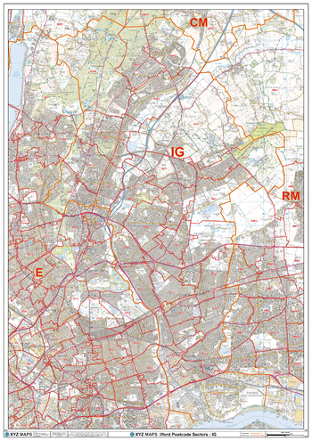
Ilford - IG - Postcode Wall Map
XYZ Maps
The Ilford Postcode Sector Wall Map shows detailed postcode sector boundaries (IG1 1, IG1 2) on a comprehensive background and is perfect for determining postcode boundaries for sales areas, planning mailshots and also an excellent reference for logistics. This wall map covers the whole of the IG Postcode Area.
Page Size: 33.25 x 47 in (841 x 1189 mm)
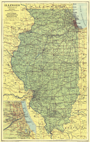
Illinois - Published 1931
National Geographic
This map of Illinois was published in May 1931, the same year Chicago's notorious gangster Al Capone was convicted and sentenced to prison for tax evasion. An inset of the city of Chicago provides additional detail in this map of the Land of Lincoln.
Page Size: 11.75 x 18.75 in (298 x 471 mm)
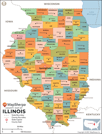
Illinois Counties Map - Extra Large
MapSherpa
This map has been created exclusively for MapSherpa, and designed for reference or business use. Clear and clean colors & fonts matched with cartographic research makes this map of Illinois Counties Map easily readable and useful. The map shows the 102 counties of Illinois and their borders across the Land of Lincoln.
Page Size: 60 x 79 in (1524 x 2001 mm)

Illinois Counties Map - Large
MapSherpa
This map has been created exclusively for MapSherpa, and designed for reference or business use. Clear and clean colors & fonts matched with cartographic research makes this map of Illinois Counties Map easily readable and useful. The map shows the 102 counties of Illinois and their borders across the Land of Lincoln.
Page Size: 48 x 63.25 in (1219 x 1601 mm)

Illinois Counties Map - Standard
MapSherpa
This map has been created exclusively for MapSherpa, and designed for reference or business use. Clear and clean colors & fonts matched with cartographic research makes this map of Illinois Counties Map easily readable and useful. The map shows the 102 counties of Illinois and their borders across the Land of Lincoln.
Page Size: 36 x 47.5 in (914 x 1201 mm)
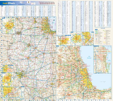
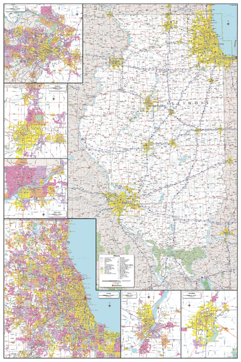
Illinois State Wall Map
Globe Turner
This colorful, easy-to-read state map of Illinois identifies all major thoroughfares, secondary roads, freeway interchanges, rest areas, distance markers, landmarks, recreational areas, and more. Shaded relief on the state map provides a three-dimensional sense of Illinois' topography. Detailed city inset maps of Bloomington/Normal, Chicago, Champaign/Urbana, Decatur, Peoria, the Quad Cities, Rockford, and Springfield are based on the latest street information from our cartographic experts. An up-to-date inset of downtown Chicago provides must-see information on the central business and tourist district. County and city indices make it simple to locate even the smallest town.
Page Size: 27.75 x 25 in (705 x 629 mm)
Illinois State Wall Map - Compact
MapSherpa
This detailed wall map of Illinois is perfect for both educational and business purposes. The easy-to-read map features vibrant colors and clear labeling of cities, counties, highways, and geographical features. All national and state highways that connect the state are all clearly labelled on the map, while the legend notes the different road and land use classifications such as urban, park, military, and many more. The boundaries of each county in the state are defined and named clearly. Whether you are a student, teacher, business person or geography enthusiast, this map is a valuable addition to any space.
Page Size: 16 x 24 in (406 x 610 mm)
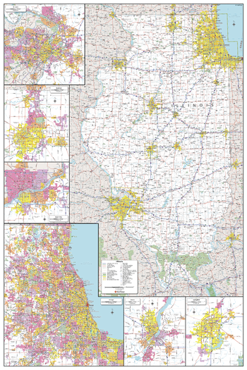
Illinois State Wall Map - Extra Large
MapSherpa
This detailed wall map of Illinois is perfect for both educational and business purposes. The easy-to-read map features vibrant colors and clear labeling of cities, counties, highways, and geographical features. All national and state highways that connect the state are all clearly labelled on the map, while the legend notes the different road and land use classifications such as urban, park, military, and many more. The boundaries of each county in the state are defined and named clearly. Whether you are a student, teacher, business person or geography enthusiast, this map is a valuable addition to any space.
Page Size: 40 x 60 in (1016 x 1524 mm)
Illinois State Wall Map - Large
MapSherpa
This detailed wall map of Illinois is perfect for both educational and business purposes. The easy-to-read map features vibrant colors and clear labeling of cities, counties, highways, and geographical features. All national and state highways that connect the state are all clearly labelled on the map, while the legend notes the different road and land use classifications such as urban, park, military, and many more. The boundaries of each county in the state are defined and named clearly. Whether you are a student, teacher, business person or geography enthusiast, this map is a valuable addition to any space.
Page Size: 32 x 48 in (813 x 1219 mm)

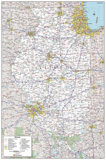
Illinois State Wall Map - Poster
MapSherpa
This detailed wall map of Illinois is perfect for both educational and business purposes. The easy-to-read map features vibrant colors and clear labeling of cities, counties, highways, and geographical features. All national and state highways that connect the state are all clearly labelled on the map, while the legend notes the different road and land use classifications such as urban, park, military, and many more. The boundaries of each county in the state are defined and named clearly. Whether you are a student, teacher, business person or geography enthusiast, this map is a valuable addition to any space.
Page Size: 24 x 36 in (610 x 914 mm)
No search results