


MapSherpa Catalog
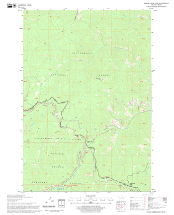
Horse Creek Pass Quadrangle, Idaho
United States Department of Agriculture Forest Service
United States Department of Agriculture Forestry Service topographical map of Horse Creek Pass, Salmon-Chalis National Forest, Idaho.
Page Size: 21.75 x 27 in (552 x 686 mm)
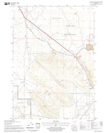
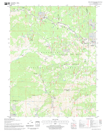
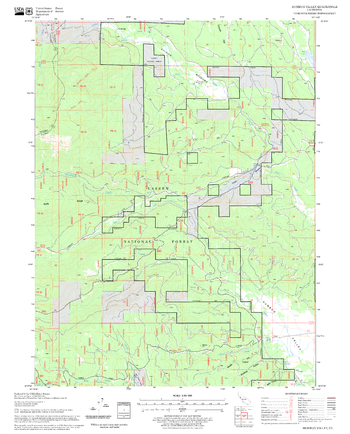
Horse Ridge Quadrangle, Oregon
United States Department of Agriculture Forest Service
United States Department of Agriculture Forestry Service topographical map of Horse Ridge, Deschutes National Forest, Oregon.
Page Size: 21.75 x 27 in (552 x 686 mm)
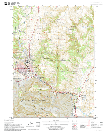
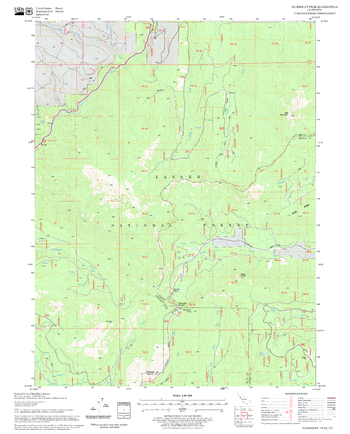
Hot Springs Quadrangle, South Dakota
United States Department of Agriculture Forest Service
United States Department of Agriculture Forestry Service topographical map of Hot Springs, Black Hills National Forest, South Dakota.
Page Size: 21.75 x 27 in (552 x 686 mm)
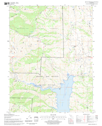
Hough Springs Quadrangle, California
United States Department of Agriculture Forest Service
United States Department of Agriculture Forestry Service topographical map of Hough Springs, Mendocino National Forest, California.
Page Size: 21.75 x 27 in (552 x 686 mm)
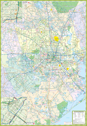
Houston and Vicinity Map
GM Johnson
Houston & Vicinity, Texas Regional Map. Map Coverage Area: Baytown, Beumont, Conroe, Galveston, Houston, La Porte, Lake Jackson, League City, Missouri City, Pasadena, Pearland, Sugar Land, Texas City, The Woodlands, & Adjoining Communities. ncluding Enlargements of: Houston Downtown & Post Oaks / Galleria Area
Page Size: 27.25 x 39.5 in (692 x 1003 mm)
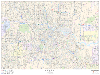
Houston, Texas Inner Metro - Landscape
MapSherpa
This landscape-oriented map of central Houston, Texas shows detailed street level information including extensive street labeling. Ideal for planning of deliveries, home services, sales territories, real estate and much more. Base map features include all roads with major roads and highways labelled; neighborhood names; railways; high level land use such as parks and recreation areas, industrial areas and hospital campuses; and a variety of points of interest including schools, libraries, stadiums, museums, border crossings and more.
Page Size: 48 x 36 in (1219 x 914 mm)
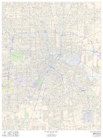
Houston, Texas Inner Metro - Portrait
MapSherpa
This portrait-oriented map of central Houston, Texas shows detailed street level information including extensive street labeling. Ideal for planning of deliveries, home services, sales territories, real estate and much more. Base map features include all roads with major roads and highways labelled; neighborhood names; railways; high level land use such as parks and recreation areas, industrial areas and hospital campuses; and a variety of points of interest including schools, libraries, stadiums, museums, border crossings and more.
Page Size: 36 x 48 in (914 x 1219 mm)
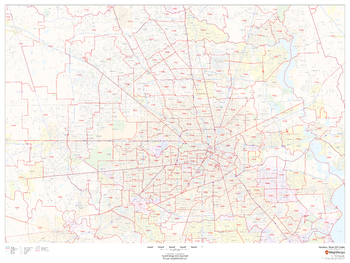
Houston, Texas ZIP Codes
MapSherpa
This map of Houston shows ZIP code areas overlaid on a road map. Ideal for planning of deliveries, home services, sales territories, real estate and much more. Base map features include all roads with major roads and highways labelled; neighborhood names; railways; and high level land use such as parks and recreation areas, industrial areas and hospital campuses.
Page Size: 48 x 36 in (1219 x 914 mm)
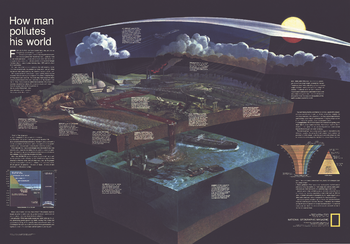
How Man Pollutes His World - Published 1970
National Geographic
Long before stewardship of the Earth was a popular topic, National Geographic was addressing these thorny issues. "How Man Pollutes His World," publiished in December fo 1970, identified and graphically demonstrated how human activities impact our fragile biosphere. Perfect for any student who wants to learn about how these forces interact.
Page Size: 42.25 x 29.5 in (1071 x 746 mm)
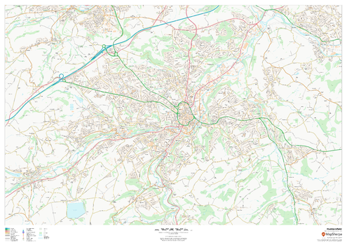
Huddersfield
MapSherpa
This map of Huddersfield shows detailed street level information including extensive street labelling. Ideal for planning of deliveries, home services, sales territories, real estate and much more.
Page Size: 47 x 33.25 in (1189 x 841 mm)
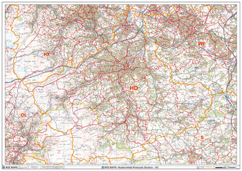
Huddersfield - HD - Postcode Wall Map
XYZ Maps
The Huddersfield Postcode Sector Wall Map shows detailed postcode sector boundaries (HD1 1, HD1 2) on a comprehensive background and is perfect for determining postcode boundaries for sales areas, planning mailshots and also an excellent reference for logistics. This wall map covers the whole of the HD Postcode Area.
Page Size: 47 x 33.25 in (1189 x 841 mm)
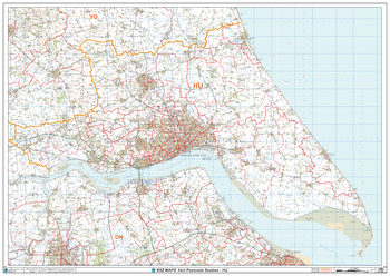
Hull - HU - Postcode Wall Map
XYZ Maps
The Hull Postcode Sector Wall Map shows detailed postcode sector boundaries (HU1 1, HU1 2) on a comprehensive background and is perfect for determining postcode boundaries for sales areas, planning mailshots and also an excellent reference for logistics. This wall map covers the whole of the HU Postcode Area.
Page Size: 47 x 33.25 in (1189 x 841 mm)
Hull Mountain Quadrangle, California
United States Department of Agriculture Forest Service
United States Department of Agriculture Forestry Service topographical map of Hull Mountain, Mendocino National Forest, California.
Page Size: 21.75 x 27 in (552 x 686 mm)
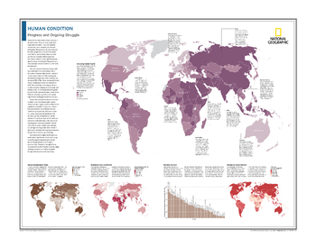
Human Condition: Progress and Ongoing Struggle - Atlas of the World, 10th Edition
National Geographic
Assessing Human Rights; Human Development Index; Mapping School Enrollment; Ranking the Poor; Measuring Global Literacy
Page Size: 28 x 22 in (711 x 559 mm)
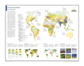
Human Influences: Into a New Epoch? - Atlas of the World, 10th Edition
National Geographic
Mapping Ecological Patterns; Human Influences Over Time; Human Influence Index; Last of the Wild; Planetary Stewardship
Page Size: 28 x 22 in (711 x 559 mm)
Humboldt Peak Quadrangle, California
United States Department of Agriculture Forest Service
United States Department of Agriculture Forestry Service topographical map of Humboldt Peak, Lassen National Forest, California.
Page Size: 21.75 x 27 in (552 x 686 mm)
Humbug Valley Quadrangle, California
United States Department of Agriculture Forest Service
United States Department of Agriculture Forestry Service topographical map of Humbug Valley, Lassen National Forest, California.
Page Size: 21.75 x 27 in (552 x 686 mm)
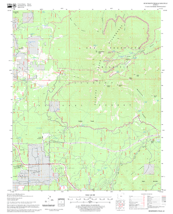
Humphreys Peak Quadrangle, Arizona
United States Department of Agriculture Forest Service
United States Department of Agriculture Forestry Service topographical map of Humphreys Peak, Coconino National Forest, Arizona.
Page Size: 21.75 x 27 in (552 x 686 mm)
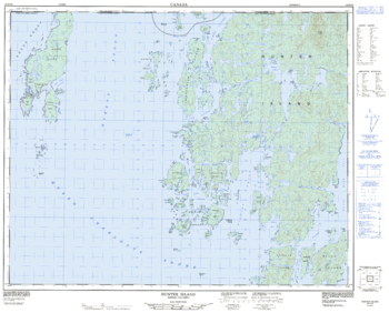
Hunter Island - 102 P/16 - British Columbia
Natural Resources Canada
Canadian topographic map of Hunter Island, British Columbia. NTS sheet 102P16 Edition 2.
Page Size: 31.5 x 25.25 in (795 x 640 mm)
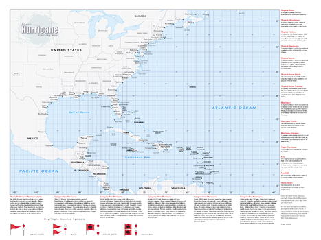
Hurricane Tracking Wall Map - Large
Globe Turner
Perfect for home, business, school, or governmental emergency planning agency, this map of the central and western North Atlantic Ocean, Caribbean Sea, and Gulf of Mexico is divided into one degree latitude and longitude grid lines to make the tracking of tropical systems easy. The map includes a glossary of tropical meteorology terms and an explanation of the Saffir-Simpson Hurricane Wind Scale.
Page Size: 33 x 44 in (838 x 1118 mm)
No search results