


MapSherpa Catalog
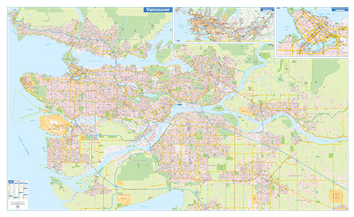
Greater Vancouver Wall Map - Street Detail - Extra Large
Lucidmap
This wall map of the Greater Vacouver Area shows highly detailed local information for the city of Vancouver and the surrounding area. Full street labeling along with transit information, parks, schools, churches and landmarks throughout the city are displayed.
The map has been designed in a very clear and legible manner with a traditional Canadian street map style embraced by map buyers over many years.
Page Size: 79 x 48 in (2007 x 1219 mm)
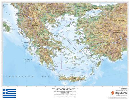
Greece
MapSherpa
This beautiful map shows physical and political features for Greece and surrounding areas. Relief shading and the use of different colours by height above sea level are both informative and attractive.
Page Size: 22 x 17 in (559 x 432 mm)
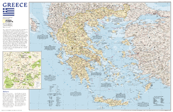
Greece - Published 2006
National Geographic
A map of Greece with an inset illustrating the historical center of Athens.
Page Size: 31.25 x 20.25 in (791 x 511 mm)
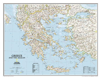
Greece Classic
National Geographic
The classic National Geographic wall map of Greece shows this beautiful area in uncompromisingly accurate detail. The map includes political boundaries, cities and towns, bodies of water, major roadways, airports, and many other geographic details.
Page Size: 30.25 x 23.5 in (768 x 597 mm)

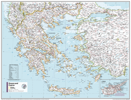
Greece and Cyprus - Atlas of the World, 11th Edition
National Geographic
This Greece, Cyprus and the Aegean Sea map of physical and political features can fit in any space. Showcasing the countries in stunning detail with state-of-the-art cartographic techniques delivering accuracy and exceptional quality, the innovative and engaging design makes the content easily accessible and user-friendly.
Ideal for classrooms with an emphasis on teaching geography or environmental themes. The inclusion of physical features gives your students a genuine feel for how our world appears.
This map uses a bright, easy to read color palette featuring blue oceans and stunning shaded relief that has been featured on National Geographic wall maps for over 75 years. It is drawn in Conic projection, in which an area of the earth is projected onto a cone whose vertex is usually above one of the poles, then unrolled onto a flat surface.
Names of geographic features are carefully placed on the map to maintain legibility. An inset of Cyprus is included.
This map is found in National Geographic's 11th Edition World Atlas and is now available as a stand alone product.
Page Size: 31.5 x 24 in (798 x 610 mm)
Greece and Cyprus - Atlas of the World, 11th Edition - Compact
National Geographic
This Greece, Cyprus and the Aegean Sea map of physical and political features can fit in any space. Showcasing the countries in stunning detail with state-of-the-art cartographic techniques delivering accuracy and exceptional quality, the innovative and engaging design makes the content easily accessible and user-friendly.
Ideal for classrooms with an emphasis on teaching geography or environmental themes. The inclusion of physical features gives your students a genuine feel for how our world appears.
This map uses a bright, easy to read color palette featuring blue oceans and stunning shaded relief that has been featured on National Geographic wall maps for over 75 years. It is drawn in Conic projection, in which an area of the earth is projected onto a cone whose vertex is usually above one of the poles, then unrolled onto a flat surface.
Names of geographic features are carefully placed on the map to maintain legibility. An inset of Cyprus is included.
This map is found in National Geographic's 11th Edition World Atlas and is now available as a stand alone product.
Page Size: 21.5 x 16.25 in (540 x 413 mm)
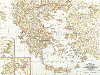
Greece and the Aegean - Published 1958
National Geographic
This map of Greece and the Aegean Islands features wonderful detail of the many islands in the region. Published in December 1958 with the article "The Aegean Isles: Poseidon's Playground."
Page Size: 25 x 19 in (633 x 478 mm)
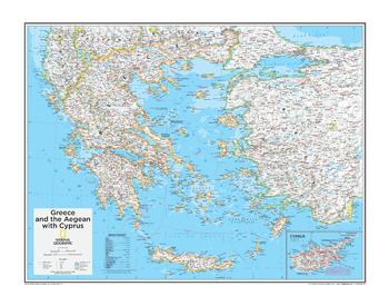
Greece and the Aegean with Cyprus - Atlas of the World, 10th Edition
National Geographic
Northern Cyprus
Page Size: 28 x 22 in (711 x 559 mm)
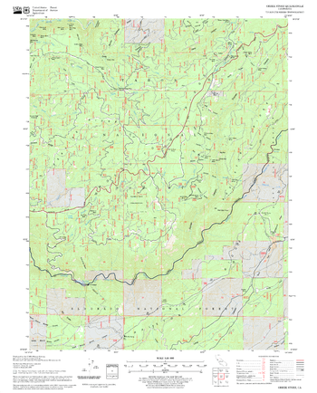
Greek Store Quadrangle, California
United States Department of Agriculture Forest Service
United States Department of Agriculture Forestry Service topographical map of Greek Store, Tahoe National Forest, California.
Page Size: 21.75 x 27 in (552 x 686 mm)
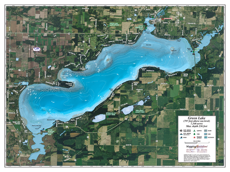
Green Lake
Mapping Specialists
An Attractive map of the lake showing a visual 3D representation of the lake bottom. Includes boat launches, rock area and vegetation. Land area is high resolution aerial imagery.
Page Size: 37.25 x 27.75 in (943 x 705 mm)
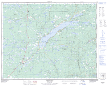
Green Lake - 92 P/6 - British Columbia
Natural Resources Canada
Canadian topographic map of Green Lake, British Columbia. NTS sheet 092P06 Edition 2.
Page Size: 32 x 25.5 in (807 x 647 mm)
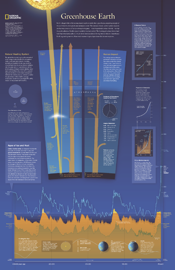
Greenhouse Earth - Published 2007
National Geographic
Published in October 2007 as half of a two-piece set with "Changing Climate," this revealing poster explains how the Earth's atmosphere acts as a greenhouse and how carbon emissions raise the planet's surface temperature. Graphs and charts reveal the origin of emissions, predicted future carbon emission levels, and the warming cycles the planet has experienced in its history.
Page Size: 20.25 x 31.25 in (512 x 790 mm)
Greenland - Atlas of the World, 10th Edition
National Geographic
null
Page Size: 22 x 28 in (559 x 711 mm)
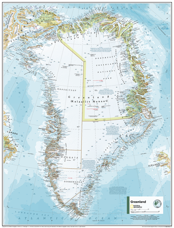
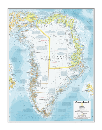
Greenland - Atlas of the World, 11th Edition
National Geographic
This Greenland map of physical and political features can fit in any space. Showcasing the nation in stunning detail with state-of-the-art cartographic techniques delivering accuracy and exceptional quality, the innovative and engaging design makes the content easily accessible and user-friendly.
Ideal for classrooms with an emphasis on teaching geography or environmental themes. The inclusion of physical features gives your students a genuine feel for how our world appears.
This map uses a bright, easy to read color palette featuring blue oceans and stunning shaded relief that has been featured on National Geographic wall maps for over 75 years. Drawn in the Azimuthal Equidistant projection, this map ensures that all points on the map are at proportionally correct distances from the center point.
Names of geographic features are carefully placed on the map to maintain legibility. Historic and geographic facts are peppered across the map for a more nuanced understanding of the landmass.
This map is found in National Geographic's 11th Edition World Atlas and is now available as a stand alone product.
Page Size: 24 x 31.5 in (610 x 798 mm)

Greenland - Atlas of the World, 11th Edition - Compact
National Geographic
This Greenland map of physical and political features can fit in any space. Showcasing the nation in stunning detail with state-of-the-art cartographic techniques delivering accuracy and exceptional quality, the innovative and engaging design makes the content easily accessible and user-friendly.
Ideal for classrooms with an emphasis on teaching geography or environmental themes. The inclusion of physical features gives your students a genuine feel for how our world appears.
This map uses a bright, easy to read color palette featuring blue oceans and stunning shaded relief that has been featured on National Geographic wall maps for over 75 years. Drawn in the Azimuthal Equidistant projection, this map ensures that all points on the map are at proportionally correct distances from the center point.
Names of geographic features are carefully placed on the map to maintain legibility. Historic and geographic facts are peppered across the map for a more nuanced understanding of the landmass.
This map is found in National Geographic's 11th Edition World Atlas and is now available as a stand alone product.
Page Size: 16.25 x 21.5 in (413 x 540 mm)
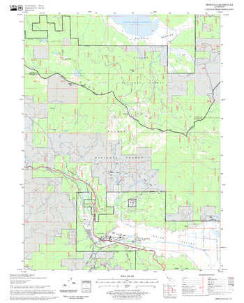
Greenville Quadrangle, California
United States Department of Agriculture Forest Service
United States Department of Agriculture Forestry Service topographical map of Greenville, Lassen National Forest, California.
Page Size: 21.75 x 27 in (552 x 686 mm)
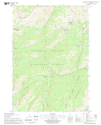
Greyhound Mountain Quadrangle, Idaho
United States Department of Agriculture Forest Service
United States Department of Agriculture Forestry Service topographical map of Greyhound Mountain, Salmon-Chalis National Forest, Idaho.
Page Size: 21.75 x 27 in (552 x 686 mm)
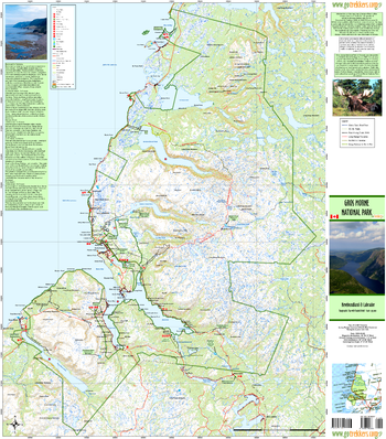
Gros Morne National Park
GoTrekkers
Gros Morne National Park
Page Size: 30 x 34 in (757 x 861 mm)
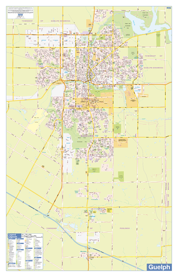
Guelph Wall Map - Street Detail
Lucidmap
This wall map shows highly detailed local information for the city of Guelph. Full street labeling along with transit information, parks, schools, churches and landmarks throughout the city are displayed.
The map has been designed in a very clear and legible manner with a traditional Canadian street map style embraced by map buyers over many years.
Page Size: 28 x 44 in (711 x 1118 mm)
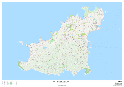
Guernsey - Channel Islands
MapSherpa
This wall map of Guernsey in the Channel Islands showcases a full road network of the island, including within Saint Peter Port. Parks, walking and bicycle paths, many buildings, and point of interest are displayed.
Page Size: 47 x 33.25 in (1189 x 841 mm)
No search results