


MapSherpa Catalog

Essex County Map
XYZ Maps
This is a large ceremonial county map of Essex highlighting the county border, with the surrounding area faded out for excellent contrast. The map covers Barking, Basildon, Colchester, Dagenham, Chelmsford, Harwich, Illford, Maldon, Romford, Saffron Waldon, Southend-on-Sea, Stansted Mountfitchet, Tilbury, Tiptree, West Ham and Woodford. The county map shows the latest County and Unitary Authority Boundaries, Overlaid on a Clear and Easy to Read Ordnance Survey1:250,000 map.
Page Size: 47 x 33.25 in (1189 x 841 mm)
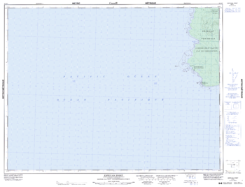
Estevan Point - 92 E/7 - British Columbia
Natural Resources Canada
Canadian topographic map of Estevan Point, British Columbia. NTS sheet 092E07 Edition 5.
Page Size: 33.25 x 25.5 in (842 x 643 mm)
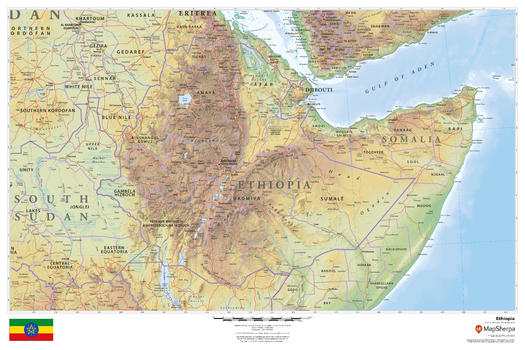
Ethiopia
MapSherpa
This beautiful map shows physical and political features for Ethiopia and surrounding areas. Relief shading and the use of different colours by height above sea level are both informative and attractive.
Page Size: 36 x 24 in (914 x 610 mm)
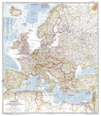
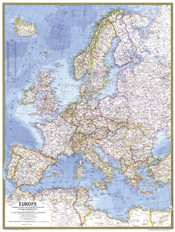
Europe - Published 1957
National Geographic
This map of Europe, created during the the Cold War, is a compelling historical piece. An inset shows which countries were Communist at the time. Published in June 1957 with an article entitled "Through Europe by Trailer Caravan."
Page Size: 29 x 33 in (735 x 838 mm)

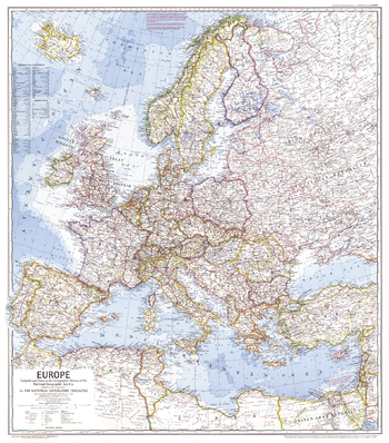
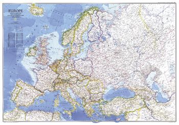
Europe - Published 1962
National Geographic
This marvelously detailed map of Europe provides a Cold War era snapshot of Europe, including the borders of Germany, Poland, and the Soviet Union as they existed in 1938. Published in June 1962 with the article "In the Crusader's Footsteps."
Page Size: 25 x 19 in (631 x 480 mm)
Europe - Published 1969
National Geographic
In comparison to earlier maps of Europe, this map is the first to show the network of superhighways criss-crossing the continent as European transportation surged. Published in June 1969, it accompanied an article entitled "Europe, A Restless Continent Remapped."
Page Size: 26.75 x 30.25 in (674 x 767 mm)
Europe - Published 1977
National Geographic
A modern Europe emerges with a network of superhighways in this map published in May 1977. This map was printed to accompany the article "The Celts" and a supplemental map entitled "Celtic Europe."
Page Size: 22.75 x 30 in (573 x 758 mm)
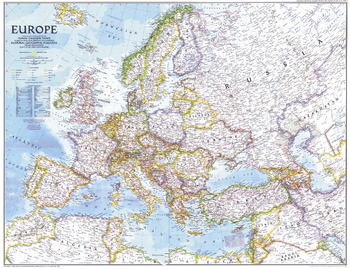
Europe - Published 1983
National Geographic
This striking map of Europe, a National Geographic classic, is vibrantly colored and beautifully rendered. Published in December 1983, during the last decade of the Cold War, as a companion to the "History of Europe, the Major Turning Points" map and four articles on Europe including "Rome of the East."
Page Size: 43.25 x 30.5 in (1098 x 770 mm)
Europe - Published 1992
National Geographic
This striking map of Europe reveals a new landscape of nations as they emerged at the end of the Cold War. A wonderful snapshot of a historic period in Europe's history. Published in December 1992 as half of a two–map set with "The New Europe."
Page Size: 28.75 x 22.25 in (728 x 559 mm)
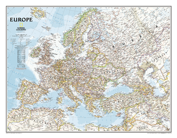
Europe Classic
National Geographic
National Geographic's classic political map of Europe features country boundaries, thousands of place names, waterbodies, airports, major highways and roads, national parks, and much more. Includes the countries and major cities of Albania, Armenia, Austria, Azerbaijan, Belarus, Belgium, Bosnia & Herzegovina, Bulgaria, Croatia, Cyprus, Czech Republic, Denmark, Estonia, Finland, France, Georgia, Germany, Greece, Hungary, Iceland, Ireland, Italy, Kosovo, Latvia, Liechtenstein, Lithuania, Luxembourg, Macedonia, Moldova, Montenegro, The Netherlands, Norway, Poland, Portugal, Romania, Russia, Serbia, Slovakia, Slovenia, Spain, Sweden, Switzerland, Turkey, Ukraine, and the United Kingdom.
Page Size: 30.5 x 24 in (772 x 605 mm)
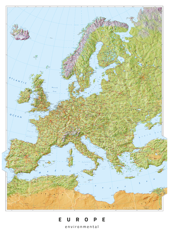
Europe Environmental
Oxford Cartographers
Europe map, with environmental colours (vegetation/desert/ice)
Page Size: 23.5 x 33.25 in (594 x 841 mm)
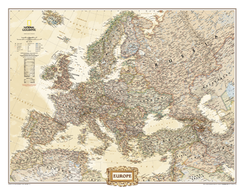
Europe Executive
National Geographic
National Geographic's antique-executive style political map of Europe features country boundaries, thousands of place names, waterbodies, airports, major highways and roads, national parks, and much more. Includes the countries and major cities of Albania, Armenia, Austria, Azerbaijan, Belarus, Belgium, Bosnia & Herzegovina, Bulgaria, Croatia, Cyprus, Czech Republic, Denmark, Estonia, Finland, France, Georgia, Germany, Greece, Hungary, Iceland, Ireland, Italy, Kosovo, Latvia, Liechtenstein, Lithuania, Luxembourg, Macedonia, Moldova, Montenegro, The Netherlands, Norway, Poland, Portugal, Romania, Russia, Serbia, Slovakia, Slovenia, Spain, Sweden, Switzerland, Turkey, Ukraine, and the United Kingdom.
Page Size: 30.5 x 24 in (772 x 605 mm)
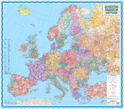
Europe Map of Post Codes - Ukrainian - Extra Large
Kartographia
This Ukrainian-language map shows postal service zones, country codes and postal codes for cities in Europe. A separate table shows the post code formats for European countries and territories.
Page Size: 48.75 x 43 in (1235 x 1090 mm)
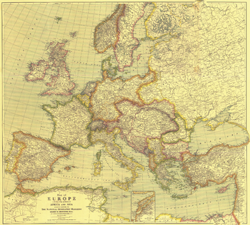
Europe Map with Africa and Asia - Published 1915
National Geographic
This beautifully rendered map of Europe was published in July 1915, one year into the First World War. A historical snapshot of a region in turmoil, this map is a must-have for map collectors, as well as those interested in The Great War. A National Geographic classic.
Page Size: 31.5 x 28.5 in (796 x 719 mm)
Europe Physical
Maps International
Our physical Europe map features the natural terrain of the land, with countries marked and borders shown. The map's key helps to identify the land elevation and water depth. This huge Europe physical map also contains city population detail, national capitals and major towns and cities.
Europe Physical - Atlas of the World, 10th Edition
National Geographic
null
Page Size: 28 x 22 in (711 x 559 mm)

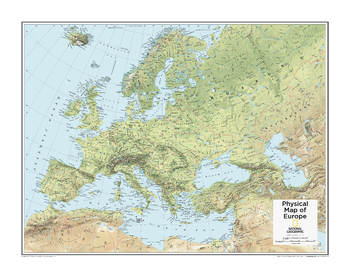
Europe Physical - Atlas of the World, 11th Edition
National Geographic
This map of Europe's physical geography can fit in any space. Showcasing Europe in stunning detail with state-of-the-art cartographic techniques delivering accuracy and exceptional quality, the innovative and engaging design makes the content easily accessible and user-friendly.
Ideal for classrooms with an emphasis on teaching geography or environmental themes. Physical wall maps give your students a genuine feel for how our world appears.
This physical map of Europe uses a bright, easy to read color palette featuring blue oceans and stunning shaded relief that has been featured on National Geographic wall maps for over 75 years. Drawn in the Azimuthal Equidistant projection, this map ensures that all points are at proportionally correct distances from the center point.
Names of geographic features such as international boundaries, cities, rivers and lakes are carefully placed on the map to maintain legibility.
This map is found in National Geographic's 11th Edition World Atlas and is now available as a stand alone product.
Page Size: 31.5 x 24 in (798 x 610 mm)
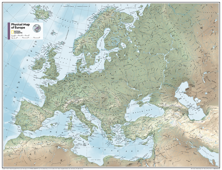
Europe Physical - Atlas of the World, 11th Edition - Compact
National Geographic
This map of Europe's physical geography can fit in any space. Showcasing Europe in stunning detail with state-of-the-art cartographic techniques delivering accuracy and exceptional quality, the innovative and engaging design makes the content easily accessible and user-friendly.
Ideal for classrooms with an emphasis on teaching geography or environmental themes. Physical wall maps give your students a genuine feel for how our world appears.
This physical map of Europe uses a bright, easy to read color palette featuring blue oceans and stunning shaded relief that has been featured on National Geographic wall maps for over 75 years. Drawn in the Azimuthal Equidistant projection, this map ensures that all points are at proportionally correct distances from the center point.
Names of geographic features such as international boundaries, cities, rivers and lakes are carefully placed on the map to maintain legibility.
This map is found in National Geographic's 11th Edition World Atlas and is now available as a stand alone product.
Page Size: 21.5 x 16.25 in (540 x 413 mm)
Europe Political
Maps International
Our politically coloured map of Europe features countries marked in different colours, with international boundaries shown. All major towns and cities of Europe are featured within our huge map, and the countries capital cities are clearly marked. The map contains hill and sea shading adding to the vibrant overall effect.
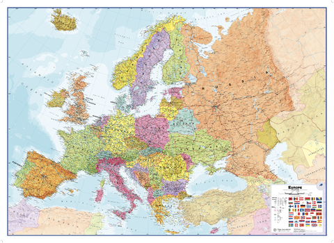
Europe Political
Maps International
Our politically coloured wall map of Europe features countries marked in different colours, with international boundaries shown. All major towns and cities of Europe are featured within our map, and the countries capital cities are clearly marked. The map contains hill and sea shading adding to the vibrant overall effect. The wall map also contains a section showing the different flags of countries in Europe.
Page Size: 53.5 x 39 in (1357 x 985 mm)
No search results