


MapSherpa Catalog
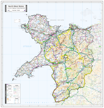
County Map of North West Wales
The Map Centre
An Ordnance Survey Map covering the whole of the county showing the county boundary including applicable Unitary Authority boundaries. The mapping outside the county boundary is faded to highlight the county. Part of a series of counties maps that cover England Scotland & Wales all using the same background Ordnance Survey Mapping for continuity across the whole series. This map includes Anglesey, Portmadog, Llandudno, Lleyn Peninsula
Page Size: 37 x 38.75 in (940 x 980 mm)
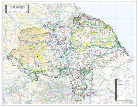
County Map of North Yorkshire
The Map Centre
An Ordnance Survey Map covering the whole of the county showing the county boundary including applicable Unitary Authority boundaries. The mapping outside the county boundary is faded to highlight the county. Part of a series of counties maps that cover England Scotland & Wales all using the same background Ordnance Survey Mapping for continuity across the whole series. This map includes Harrogate, York
Page Size: 45.75 x 35.5 in (1160 x 900 mm)
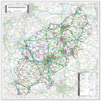
County Map of Northamptonshire
The Map Centre
An Ordnance Survey Map covering the whole of the county showing the county boundary including applicable Unitary Authority boundaries. The mapping outside the county boundary is faded to highlight the county. Part of a series of counties maps that cover England Scotland & Wales all using the same background Ordnance Survey Mapping for continuity across the whole series. This map includes Northampton
Page Size: 34 x 34 in (860 x 860 mm)
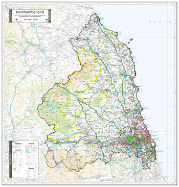
County Map of Northumberland
The Map Centre
An Ordnance Survey Map covering the whole of the county showing the county boundary including applicable Unitary Authority boundaries. The mapping outside the county boundary is faded to highlight the county. Part of a series of counties maps that cover England Scotland & Wales all using the same background Ordnance Survey Mapping for continuity across the whole series. This map includes Newcastle upon Tyne, Alnwick, Berwick upon Tweed
Page Size: 34 x 35.5 in (860 x 900 mm)
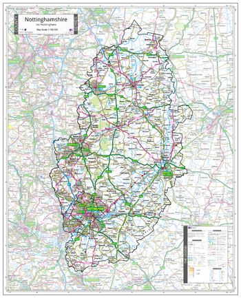
County Map of Nottinghamshire
The Map Centre
An Ordnance Survey Map covering the whole of the county showing the county boundary including applicable Unitary Authority boundaries. The mapping outside the county boundary is faded to highlight the county. Part of a series of counties maps that cover England Scotland & Wales all using the same background Ordnance Survey Mapping for continuity across the whole series. This map includes Nottingham, Mansfield
Page Size: 30 x 37 in (760 x 940 mm)
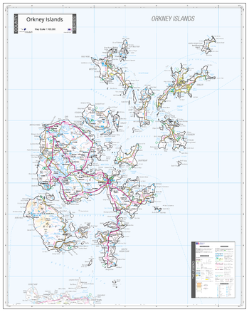
County Map of Orkney
The Map Centre
An Ordnance Survey Map covering the whole of the county showing the county boundary including applicable Unitary Authority boundaries. The mapping outside the county boundary is faded to highlight the county. Part of a series of counties maps that cover England Scotland & Wales all using the same background Ordnance Survey Mapping for continuity across the whole series. This map includes Kirkwall, Hoy
Page Size: 31.5 x 39.5 in (800 x 1000 mm)
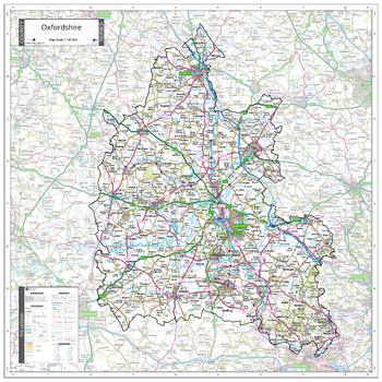
County Map of Oxfordshire
The Map Centre
An Ordnance Survey Map covering the whole of the county showing the county boundary including applicable Unitary Authority boundaries. The mapping outside the county boundary is faded to highlight the county. Part of a series of counties maps that cover England Scotland & Wales all using the same background Ordnance Survey Mapping for continuity across the whole series. This map includes Oxford, Witney
Page Size: 35.5 x 35.5 in (900 x 900 mm)
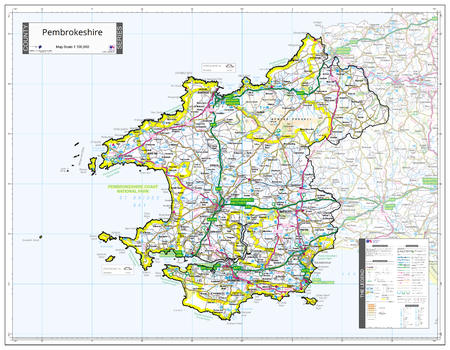
County Map of Pembrokeshire
The Map Centre
An Ordnance Survey Map covering the whole of the county showing the county boundary including applicable Unitary Authority boundaries. The mapping outside the county boundary is faded to highlight the county. Part of a series of counties maps that cover England Scotland & Wales all using the same background Ordnance Survey Mapping for continuity across the whole series. This map includes Pembroke, St Davids
Page Size: 35.5 x 27.75 in (900 x 700 mm)
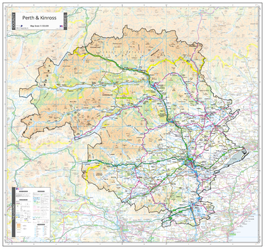
County Map of Perth & Kinross
The Map Centre
An Ordnance Survey Map covering the whole of the county showing the county boundary including applicable Unitary Authority boundaries. The mapping outside the county boundary is faded to highlight the county. Part of a series of counties maps that cover England Scotland & Wales all using the same background Ordnance Survey Mapping for continuity across the whole series. This map includes Perth, Pitlochry
Page Size: 38 x 35.5 in (960 x 900 mm)
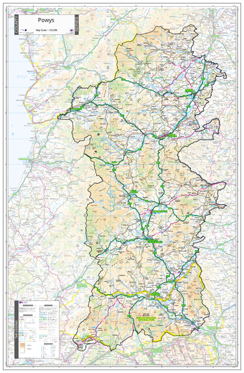
County Map of Powys
The Map Centre
An Ordnance Survey Map covering the whole of the county showing the county boundary including applicable Unitary Authority boundaries. The mapping outside the county boundary is faded to highlight the county. Part of a series of counties maps that cover England Scotland & Wales all using the same background Ordnance Survey Mapping for continuity across the whole series. This map includes Llandrindod Wells, Builth Wells, Rhayder, Welshpool, Brecon
Page Size: 30 x 45.75 in (760 x 1160 mm)
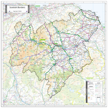
County Map of Scottish Borders
The Map Centre
An Ordnance Survey Map covering the whole of the county showing the county boundary including applicable Unitary Authority boundaries. The mapping outside the county boundary is faded to highlight the county. Part of a series of counties maps that cover England Scotland & Wales all using the same background Ordnance Survey Mapping for continuity across the whole series. This map includes Galasheils, Kelso, Melrose
Page Size: 35.5 x 35.5 in (900 x 900 mm)
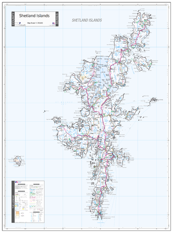
County Map of Shetland
The Map Centre
An Ordnance Survey Map covering the whole of the county showing the county boundary including applicable Unitary Authority boundaries. The mapping outside the county boundary is faded to highlight the county. Part of a series of counties maps that cover England Scotland & Wales all using the same background Ordnance Survey Mapping for continuity across the whole series. This map includes Lerwick
Page Size: 29.25 x 39.5 in (740 x 1000 mm)
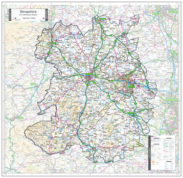
County Map of Shropshire
The Map Centre
An Ordnance Survey Map covering the whole of the county showing the county boundary including applicable Unitary Authority boundaries. The mapping outside the county boundary is faded to highlight the county. Part of a series of counties maps that cover England Scotland & Wales all using the same background Ordnance Survey Mapping for continuity across the whole series. This map includes Shrewsbury, Telford, Ludlow
Page Size: 37 x 36.25 in (940 x 920 mm)
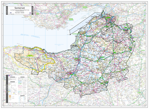
County Map of Somerset
The Map Centre
An Ordnance Survey Map covering the whole of the county showing the county boundary including applicable Unitary Authority boundaries. The mapping outside the county boundary is faded to highlight the county. Part of a series of counties maps that cover England Scotland & Wales all using the same background Ordnance Survey Mapping for continuity across the whole series. This map includes Taunton, Bristol, Bath
Page Size: 43.5 x 31.5 in (1100 x 800 mm)
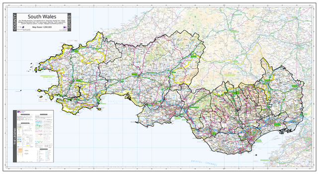
County Map of South Wales
The Map Centre
An Ordnance Survey Map covering the whole of the county showing the county boundary including applicable Unitary Authority boundaries. The mapping outside the county boundary is faded to highlight the county. Part of a series of counties maps that cover England Scotland & Wales all using the same background Ordnance Survey Mapping for continuity across the whole series. This map includes Cardiff, Swansea, Newport
Page Size: 43.5 x 23.75 in (1100 x 600 mm)
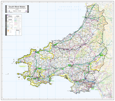
County Map of South West Wales
The Map Centre
An Ordnance Survey Map covering the whole of the county showing the county boundary including applicable Unitary Authority boundaries. The mapping outside the county boundary is faded to highlight the county. Part of a series of counties maps that cover England Scotland & Wales all using the same background Ordnance Survey Mapping for continuity across the whole series. This map includes St Davids, Pembroke, Pembroke Docks, The Gower, Aberystwyth
Page Size: 38.75 x 34 in (980 x 860 mm)
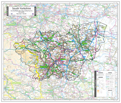
County Map of South Yorkshire
The Map Centre
An Ordnance Survey Map covering the whole of the county showing the county boundary including applicable Unitary Authority boundaries. The mapping outside the county boundary is faded to highlight the county. Part of a series of counties maps that cover England Scotland & Wales all using the same background Ordnance Survey Mapping for continuity across the whole series. This map includes Sheffield, Barnsley, Rotherham, Doncaster
Page Size: 32.5 x 27.75 in (820 x 700 mm)
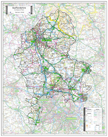
County Map of Staffordshire
The Map Centre
An Ordnance Survey Map covering the whole of the county showing the county boundary including applicable Unitary Authority boundaries. The mapping outside the county boundary is faded to highlight the county. Part of a series of counties maps that cover England Scotland & Wales all using the same background Ordnance Survey Mapping for continuity across the whole series. This map includes Stafford, Utoxeter, Stoke on Trent
Page Size: 32.5 x 41 in (820 x 1040 mm)
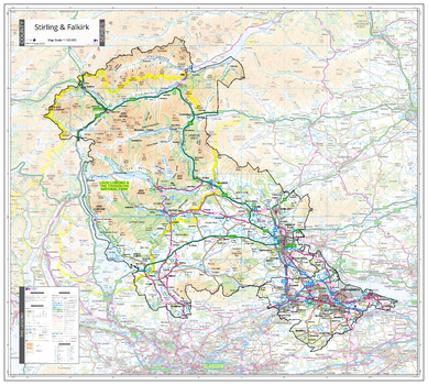
County Map of Stirling & Falkirk
The Map Centre
An Ordnance Survey Map covering the whole of the county showing the county boundary including applicable Unitary Authority boundaries. The mapping outside the county boundary is faded to highlight the county. Part of a series of counties maps that cover England Scotland & Wales all using the same background Ordnance Survey Mapping for continuity across the whole series. This map includes Stirling, Falkirk
Page Size: 39.5 x 35.5 in (1000 x 900 mm)
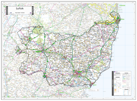
County Map of Suffolk
The Map Centre
An Ordnance Survey Map covering the whole of the county showing the county boundary including applicable Unitary Authority boundaries. The mapping outside the county boundary is faded to highlight the county. Part of a series of counties maps that cover England Scotland & Wales all using the same background Ordnance Survey Mapping for continuity across the whole series. This map includes Ipswich, Bungay, Bury St Edmunds
Page Size: 39.5 x 29.25 in (1000 x 740 mm)
No search results