


MapSherpa Catalog
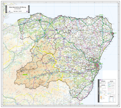
County Map of Aberdeen & Moray
The Map Centre
An Ordnance Survey Map covering the whole of the county showing the county boundary including applicable Unitary Authority boundaries. The mapping outside the county boundary is faded to highlight the county. Part of a series of counties maps that cover England Scotland & Wales all using the same background Ordnance Survey Mapping for continuity across the whole series. This map includes Aberdeen, Peterhead
Page Size: 39.5 x 35.5 in (1000 x 900 mm)
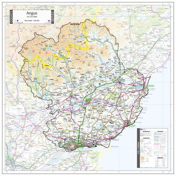
County Map of Angus
The Map Centre
An Ordnance Survey Map covering the whole of the county showing the county boundary including applicable Unitary Authority boundaries. The mapping outside the county boundary is faded to highlight the county. Part of a series of counties maps that cover England Scotland & Wales all using the same background Ordnance Survey Mapping for continuity across the whole series. This map includes Dundee, Arbroath, Montrose
Page Size: 31.5 x 31.5 in (800 x 800 mm)
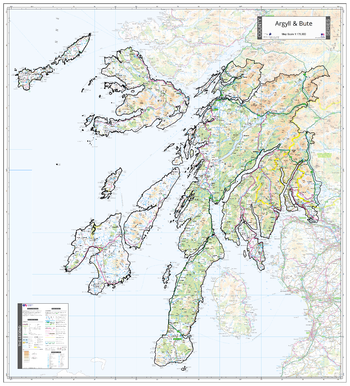
County Map of Argyll & Bute
The Map Centre
An Ordnance Survey Map covering the whole of the county showing the county boundary including applicable Unitary Authority boundaries. The mapping outside the county boundary is faded to highlight the county. Part of a series of counties maps that cover England Scotland & Wales all using the same background Ordnance Survey Mapping for continuity across the whole series. This map includes Isle of Mull, Oban
Page Size: 38 x 41.75 in (960 x 1060 mm)
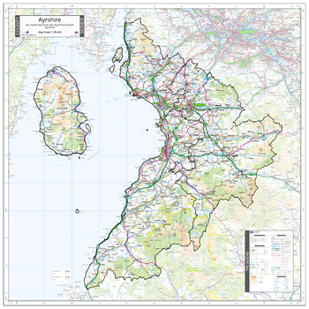
County Map of Ayrshire
The Map Centre
An Ordnance Survey Map covering the whole of the county showing the county boundary including applicable Unitary Authority boundaries. The mapping outside the county boundary is faded to highlight the county. Part of a series of counties maps that cover England Scotland & Wales all using the same background Ordnance Survey Mapping for continuity across the whole series. This map includes Ayr, Isle of Arran
Page Size: 35.5 x 35.5 in (900 x 900 mm)

County Map of Bedfordshire
The Map Centre
An Ordnance Survey Map covering the whole of the county showing the county boundary including applicable Unitary Authority boundaries. The mapping outside the county boundary is faded to highlight the county. Part of a series of counties maps that cover England Scotland & Wales all using the same background Ordnance Survey Mapping for continuity across the whole series. This map covers Bedford, Luton and Dunstable
Page Size: 27 x 31.5 in (680 x 800 mm)
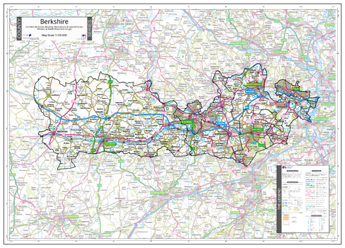
County Map of Berkshireshire
The Map Centre
An Ordnance Survey Map covering the whole of the county showing the county boundary including applicable Unitary Authority boundaries. The mapping outside the county boundary is faded to highlight the county. Part of a series of counties maps that cover England Scotland & Wales all using the same background Ordnance Survey Mapping for continuity across the whole series. This map includes Reading, Newbury, Bracknell, Windsor, Maidenhead, Slough
Page Size: 36.25 x 26 in (920 x 660 mm)
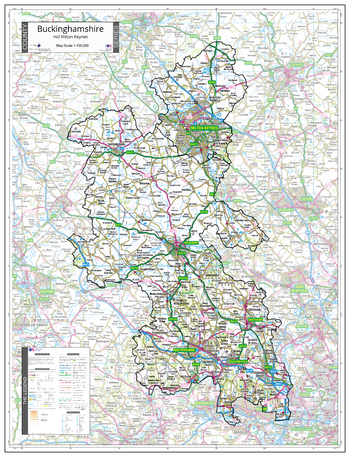
County Map of Buckinghamshire
The Map Centre
An Ordnance Survey Map covering the whole of the county showing the county boundary including applicable Unitary Authority boundaries. The mapping outside the county boundary is faded to highlight the county. Part of a series of counties maps that cover England Scotland & Wales all using the same background Ordnance Survey Mapping for continuity across the whole series. This map includes Milton Keynes, High Wycombe, Aylesbury, Amersham
Page Size: 28.5 x 37 in (720 x 940 mm)
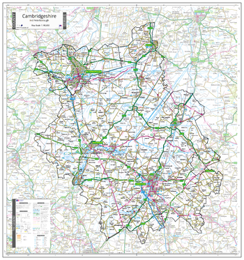
County Map of Cambridgeshire
The Map Centre
An Ordnance Survey Map covering the whole of the county showing the county boundary including applicable Unitary Authority boundaries. The mapping outside the county boundary is faded to highlight the county. Part of a series of counties maps that cover England Scotland & Wales all using the same background Ordnance Survey Mapping for continuity across the whole series. This map includes Cambridge, Peterborough
Page Size: 35.5 x 38 in (900 x 960 mm)
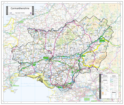
County Map of Carmarthenshire
The Map Centre
An Ordnance Survey Map covering the whole of the county showing the county boundary including applicable Unitary Authority boundaries. The mapping outside the county boundary is faded to highlight the county. Part of a series of counties maps that cover England Scotland & Wales all using the same background Ordnance Survey Mapping for continuity across the whole series. This map includes Carmarthen, Llandovery
Page Size: 35.5 x 30 in (900 x 760 mm)
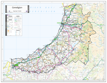
County Map of Ceredigion
The Map Centre
An Ordnance Survey Map covering the whole of the county showing the county boundary including applicable Unitary Authority boundaries. The mapping outside the county boundary is faded to highlight the county. Part of a series of counties maps that cover England Scotland & Wales all using the same background Ordnance Survey Mapping for continuity across the whole series. This map includes Cardigan, Aberystwyth
Page Size: 35.5 x 27.75 in (900 x 700 mm)
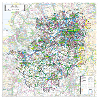
County Map of Cheshire
The Map Centre
An Ordnance Survey Map covering the whole of the county showing the county boundary including applicable Unitary Authority boundaries. The mapping outside the county boundary is faded to highlight the county. Part of a series of counties maps that cover England Scotland & Wales all using the same background Ordnance Survey Mapping for continuity across the whole series. This map includes Chester, Crewe, Greater Manchester, Macclesfield
Page Size: 38 x 38 in (960 x 960 mm)
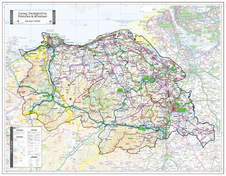
County Map of Conwy, Denbigh, Flint & Wrexham
The Map Centre
An Ordnance Survey Map covering the whole of the county showing the county boundary including applicable Unitary Authority boundaries. The mapping outside the county boundary is faded to highlight the county. Part of a series of counties maps that cover England Scotland & Wales all using the same background Ordnance Survey Mapping for continuity across the whole series. This map includes Wrexham, Flint, Llandudno
Page Size: 39.5 x 30.75 in (1000 x 780 mm)
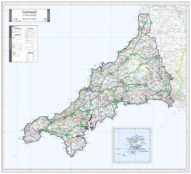
County Map of Cornwall
The Map Centre
An Ordnance Survey Map covering the whole of the county showing the county boundary including applicable Unitary Authority boundaries. The mapping outside the county boundary is faded to highlight the county. Part of a series of counties maps that cover England Scotland & Wales all using the same background Ordnance Survey Mapping for continuity across the whole series. This map includes Truro, Land's End, St Ives, St Austell
Page Size: 37 x 34 in (940 x 860 mm)
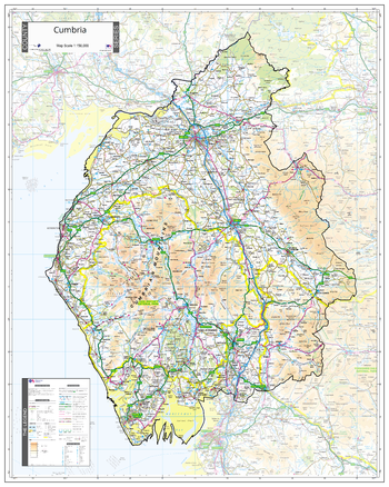
County Map of Cumbria
The Map Centre
An Ordnance Survey Map covering the whole of the county showing the county boundary including applicable Unitary Authority boundaries. The mapping outside the county boundary is faded to highlight the county. Part of a series of counties maps that cover England Scotland & Wales all using the same background Ordnance Survey Mapping for continuity across the whole series. This map includes Keswick, Ambleside, Windermere, carlisle, Penrith
Page Size: 31.5 x 39.5 in (800 x 1000 mm)
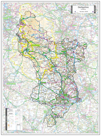
County Map of Derbyshire
The Map Centre
An Ordnance Survey Map covering the whole of the county showing the county boundary including applicable Unitary Authority boundaries. The mapping outside the county boundary is faded to highlight the county. Part of a series of counties maps that cover England Scotland & Wales all using the same background Ordnance Survey Mapping for continuity across the whole series. This map includes Derby, Buxton, Chesterfield
Page Size: 32.5 x 43.5 in (820 x 1100 mm)
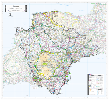
County Map of Devon
The Map Centre
An Ordnance Survey Map covering the whole of the county showing the county boundary including applicable Unitary Authority boundaries. The mapping outside the county boundary is faded to highlight the county. Part of a series of counties maps that cover England Scotland & Wales all using the same background Ordnance Survey Mapping for continuity across the whole series. This map includes Plymouth, Torbay, Exeter
Page Size: 39.5 x 36.25 in (1000 x 920 mm)
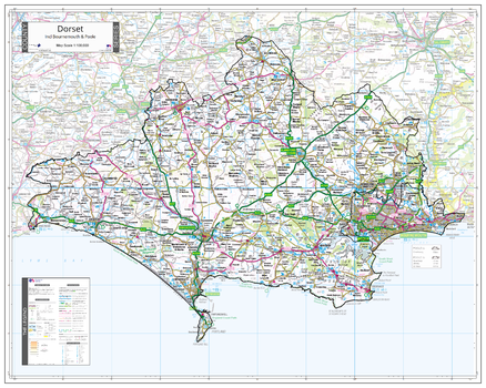
County Map of Dorset
The Map Centre
An Ordnance Survey Map covering the whole of the county showing the county boundary including applicable Unitary Authority boundaries. The mapping outside the county boundary is faded to highlight the county. Part of a series of counties maps that cover England Scotland & Wales all using the same background Ordnance Survey Mapping for continuity across the whole series. This map includes Dorchester, Bournemouth, Poole, Wemouth
Page Size: 39.5 x 31.5 in (1000 x 800 mm)
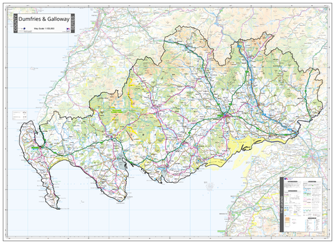
County Map of Dumfries & Galloway
The Map Centre
An Ordnance Survey Map covering the whole of the county showing the county boundary including applicable Unitary Authority boundaries. The mapping outside the county boundary is faded to highlight the county. Part of a series of counties maps that cover England Scotland & Wales all using the same background Ordnance Survey Mapping for continuity across the whole series. This map includes Dumfires, Stranraer
Page Size: 43.5 x 31.5 in (1100 x 800 mm)
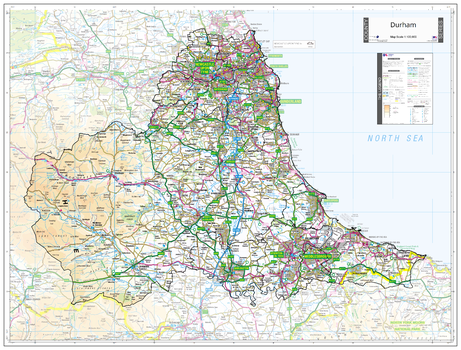
County Map of Durham
The Map Centre
An Ordnance Survey Map covering the whole of the county showing the county boundary including applicable Unitary Authority boundaries. The mapping outside the county boundary is faded to highlight the county. Part of a series of counties maps that cover England Scotland & Wales all using the same background Ordnance Survey Mapping for continuity across the whole series. This map includes Durham, Newcastle upon Tyne, Sunderland
Page Size: 45.75 x 34.75 in (1160 x 880 mm)
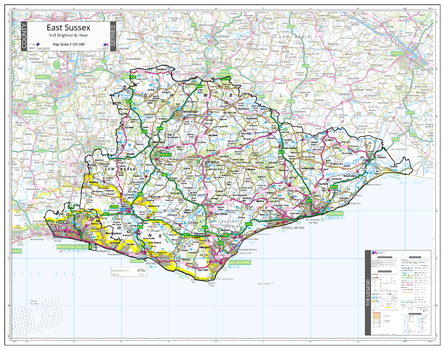
County Map of East Sussex
The Map Centre
An Ordnance Survey Map covering the whole of the county showing the county boundary including applicable Unitary Authority boundaries. The mapping outside the county boundary is faded to highlight the county. Part of a series of counties maps that cover England Scotland & Wales all using the same background Ordnance Survey Mapping for continuity across the whole series. This map includes Brighton, Hove, Eastbourne, Hastings
Page Size: 37 x 29.25 in (940 x 740 mm)
No search results