MapSherpa Catalog

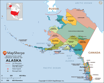
Alaska Boroughs and Census Areas (Counties) Map - Extra Large
MapSherpa
This map has been created exclusively for MapSherpa, and designed for reference or business use. Clear and clean colors & fonts matched with cartographic research makes this map of the 30 Alaska boroughs and census areas easily readable and useful.
Page Size: 60 x 48 in (1524 x 1213 mm)

Alaska Boroughs and Census Areas (Counties) Map - Large
MapSherpa
This map has been created exclusively for MapSherpa, and designed for reference or business use. Clear and clean colors & fonts matched with cartographic research makes this map of the 30 Alaska boroughs and census areas easily readable and useful.
Page Size: 48 x 38.25 in (1219 x 970 mm)
Alaska Boroughs and Census Areas (Counties) Map - Standard
MapSherpa
This map has been created exclusively for MapSherpa, and designed for reference or business use. Clear and clean colors & fonts matched with cartographic research makes this map of the 30 Alaska boroughs and census areas easily readable and useful.
Page Size: 36 x 28.75 in (914 x 728 mm)
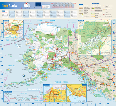
Alaska State Wall Map
Globe Turner
This colorful, easy-to-read state map of Alaska identifies all major thoroughfares, secondary roads, freeway interchanges, rest areas, distance markers, landmarks, recreational areas, and more. Shaded relief on the state map provides a three-dimensional sense of Alaska's topography. Detailed city inset maps of Anchorage, Fairbanks and Juneau are based on the latest street information from our cartographic experts. The map also includes an up-to-date inset of Denali National Park. A city index makes it simple to locate even the smallest town.
Page Size: 16.75 x 15.25 in (425 x 387 mm)
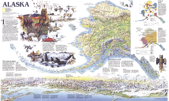
Alaska Theme - Published 1994
National Geographic
This attractive physical map of Alaska was published in May 1994 to accompany the political map of the state and the article "Alaska's Sky-High Wilderness." Besides its extraordinary geographical details, this map also contains information on federal lands, wildlife and the alaskan natives.
Page Size: 37 x 22.25 in (935 x 560 mm)

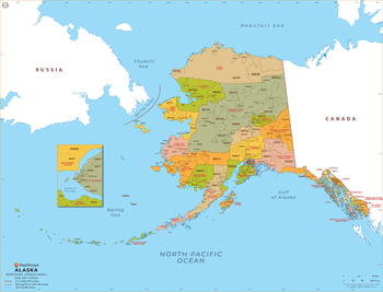
Alaska ZIP Code Map with Boroughs and Census Areas (Counties) - Extra Large
MapSherpa
This map has been created exclusively for MapSherpa, and designed for business or reference use. Clear and clean colors & fonts matched with cartographic research makes this map of Alaska's boroughs, census areas and ZIP codes easily readable and useful.
Page Size: 60 x 46 in (1524 x 1164 mm)

Alaska ZIP Code Map with Boroughs and Census Areas (Counties) - Large
MapSherpa
This map has been created exclusively for MapSherpa, and designed for business or reference use. Clear and clean colors & fonts matched with cartographic research makes this map of Alaska's boroughs, census areas and ZIP codes easily readable and useful.
Page Size: 48 x 36.75 in (1219 x 931 mm)
Alaska ZIP Code Map with Boroughs and Census Areas (Counties) - Standard
MapSherpa
This map has been created exclusively for MapSherpa, and designed for business or reference use. Clear and clean colors & fonts matched with cartographic research makes this map of Alaska's boroughs, census areas and ZIP codes easily readable and useful.
Page Size: 36 x 27.75 in (914 x 699 mm)
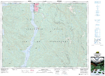
Alberni Inlet - 92 F/2 - British Columbia
Natural Resources Canada
Canadian topographic map of Alberni Inlet, British Columbia. NTS sheet 092F02 Edition 6.
Page Size: 35.75 x 26.25 in (908 x 662 mm)
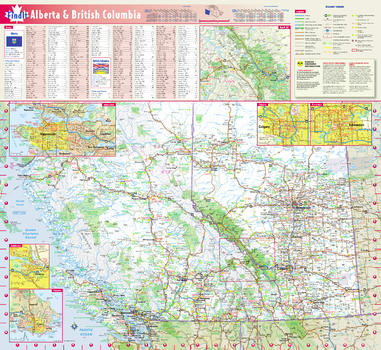
Alberta & British Columbia Wall Map
Globe Turner
This colorful, easy-to-read province map of Alberta & British Columbia identifies all major thoroughfares, secondary roads, freeway interchanges, rest areas, distance markers, landmarks, recreational areas, and more. Shaded relief on the province map provides a three-dimensional sense of Alberta & British Columbia's topography. Detailed city inset maps of Calgary, Edmonton, Vancouver, Victoria and Kamloops are based on the latest street information from our cartographic experts. The map also includes up-to-date inset of Banff National Park, as well as the latest border crossing information. A city index makes it simple to locate even the smallest town.
Page Size: 19.75 x 21.75 in (502 x 546 mm)
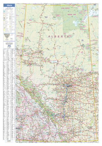
Alberta Wall Map
Lucidmap
This wall map has been designed to show important features in Alberta, including all highways, cities and towns, major parks, political boundaries, and points of interest.
The map has been designed with a traditional Canadian style embraced by map buyers over many years.
Page Size: 28 x 40 in (711 x 1016 mm)
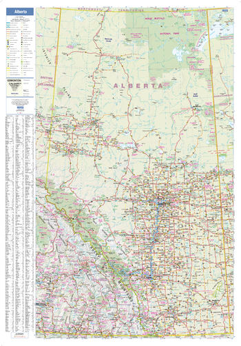
Alberta Wall Map - Large
Lucidmap
This large wall map has been designed to show important features in Alberta, including all highways, cities and towns, major parks, political boundaries, and points of interest.
The map has been designed with a traditional Canadian style embraced by map buyers over many years.
Page Size: 37.5 x 54 in (953 x 1372 mm)
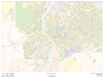
Albuquerque, New Mexico Inner Metro - Landscape
MapSherpa
This landscape-oriented map of central Albuquerque, New Mexico shows detailed street level information including extensive street labeling. Ideal for planning of deliveries, home services, sales territories, real estate and much more. Base map features include all roads with major roads and highways labelled; neighborhood names; railways; high level land use such as parks and recreation areas, industrial areas and hospital campuses; and a variety of points of interest including schools, libraries, stadiums, museums, border crossings and more.
Page Size: 48 x 36 in (1219 x 914 mm)
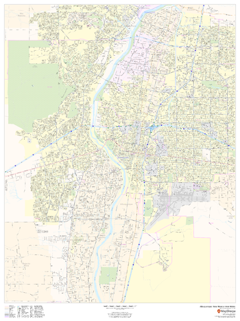
Albuquerque, New Mexico Inner Metro - Portrait
MapSherpa
This portrait-oriented map of central Albuquerque, New Mexico shows detailed street level information including extensive street labeling. Ideal for planning of deliveries, home services, sales territories, real estate and much more. Base map features include all roads with major roads and highways labelled; neighborhood names; railways; high level land use such as parks and recreation areas, industrial areas and hospital campuses; and a variety of points of interest including schools, libraries, stadiums, museums, border crossings and more.
Page Size: 36 x 48 in (914 x 1219 mm)
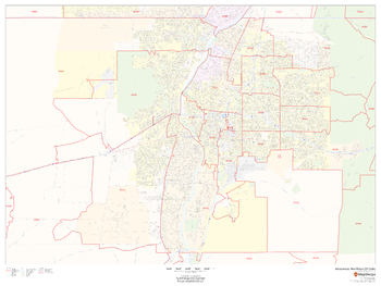
Albuquerque, New Mexico ZIP Codes
MapSherpa
This map of Albuquerque, New Mexico shows ZIP code areas overlaid on a road map. Ideal for planning of deliveries, home services, sales territories, real estate and much more. Base map features include all roads with major roads and highways labelled; neighborhood names; railways; and high level land use such as parks and recreation areas, industrial areas and hospital campuses.
Page Size: 48 x 36 in (1219 x 914 mm)

Alder Springs Quadrangle, California
United States Department of Agriculture Forest Service
United States Department of Agriculture Forestry Service topographical map of Alder Springs, Mendocino National Forest, California.
Page Size: 21.75 x 27 in (552 x 686 mm)
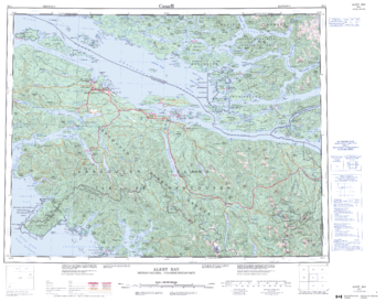
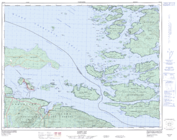
Alert Bay - 92 L - British Columbia
Natural Resources Canada
Canadian topographic map of Alert Bay, British Columbia. NTS sheet 092L Edition 3.
Page Size: 28 x 22 in (711 x 557 mm)
Alert Bay - 92 L/10 - British Columbia
Natural Resources Canada
Canadian topographic map of Alert Bay, British Columbia. NTS sheet 092L10 Edition 2.
Page Size: 32 x 25.25 in (809 x 640 mm)
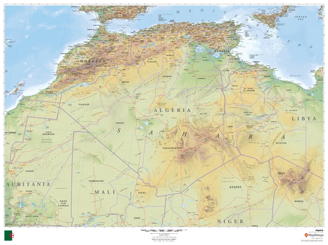
Algeria
MapSherpa
This beautiful map shows physical and political features for Algeria and surrounding areas. Relief shading and the use of different colours by height above sea level are both informative and attractive.
Page Size: 48 x 36 in (1219 x 914 mm)
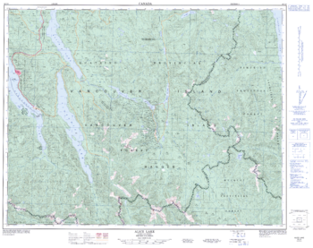
Alice Lake - 92 L/6 - British Columbia
Natural Resources Canada
Canadian topographic map of Alice Lake, British Columbia. NTS sheet 092L06 Edition 3.
Page Size: 32.25 x 25.5 in (814 x 644 mm)
No search results