


MapSherpa Catalog
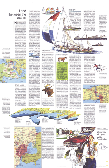
Close-up USA, Wisconsin, Michigan, and the Great Lakes, Land Between the Waters Theme - Published 1973
National Geographic
Part of the "Close-up: U.S.A." series, the "Wisconsin, Michigan, and the Great Lakes: Land Between the Waters" travel map is half of a two-map set, accompanied by the Wisconsin, Michigan, and the Great Lakes map. Published in August 1973, it contains inset maps of the Welland Canal and selected rivers as well as travel information and tips for motorists.
Page Size: 22.75 x 35 in (575 x 887 mm)
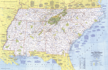
Close-up USA, the Southeast - Published 1975
National Geographic
This map lets you explore the Southeast United States. From the Atlantic seashore to the mighty Mississippi River, this area is rich in history and character. Published in October 1975 as part of the "Close-up: U.S.A." series, with the travel poster "Tennessee, North Carolina, South Carolina, Georgia, Alabama, and Mississippi."
Page Size: 35 x 22.75 in (888 x 577 mm)
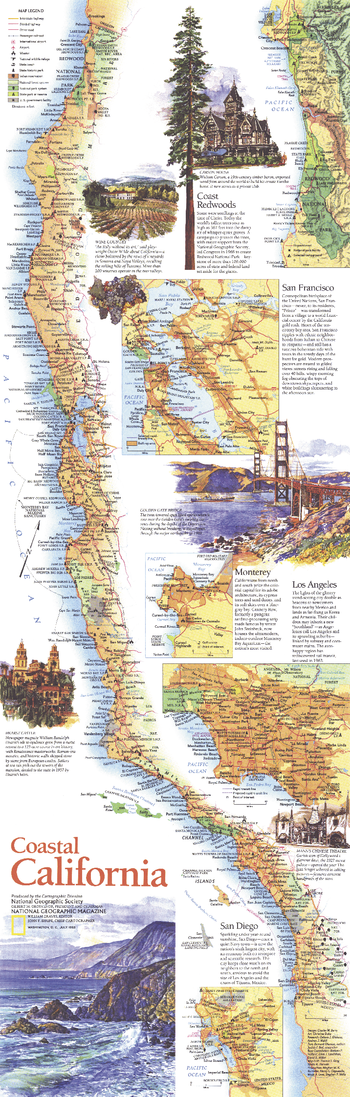
Coastal California - Published 1993
National Geographic
Published in July 1993 as half of a two-map set, this beautifully illustrated map of Coastal California highlights the sites and activities to be found along this extraordinary coastline. From the magnificent redwoods to the sunny beaches of San Diego, this map documents the diverse regions to be experienced along the coastline of the Golden State.
Page Size: 10 x 31.25 in (253 x 792 mm)
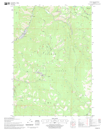
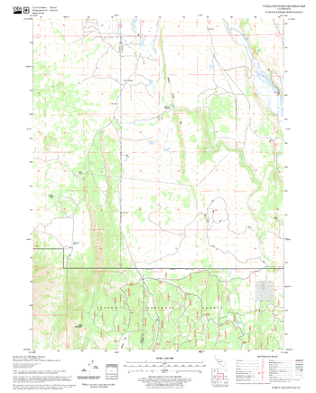
Cobalt Quadrangle, Idaho
United States Department of Agriculture Forest Service
United States Department of Agriculture Forestry Service topographical map of Cobalt, Salmon-Chalis National Forest, Idaho.
Page Size: 21.75 x 27 in (552 x 686 mm)
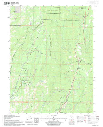
Coble Mountain Quadrangle, California
United States Department of Agriculture Forest Service
United States Department of Agriculture Forestry Service topographical map of Coble Mountain, Lassen National Forest, California.
Page Size: 21.75 x 27 in (552 x 686 mm)
Cohasset Quadrangle, California
United States Department of Agriculture Forest Service
United States Department of Agriculture Forestry Service topographical map of Cohasset, Lassen National Forest, California.
Page Size: 21.75 x 27 in (552 x 686 mm)
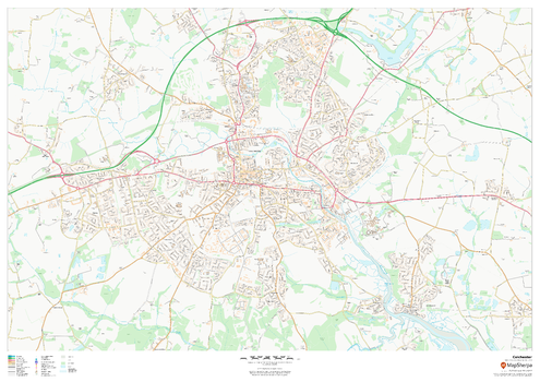
Colchester
MapSherpa
This map of Colchester shows detailed street level information including extensive street labelling. Ideal for planning of deliveries, home services, sales territories, real estate and much more.
Page Size: 47 x 33.25 in (1189 x 841 mm)

Colchester - CO - Postcode Wall Map
XYZ Maps
The Colchester Postcode Sector Wall Map shows detailed postcode sector boundaries (CO1 1, CO1 2) on a comprehensive background and is perfect for determining postcode boundaries for sales areas, planning mailshots and also an excellent reference for logistics. This wall map covers the whole of the CO Postcode Area.
Page Size: 47 x 33.25 in (1189 x 841 mm)
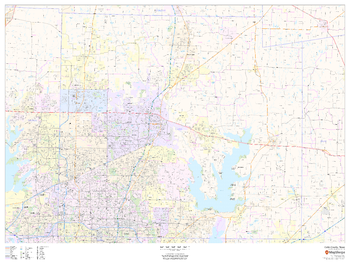
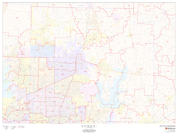
Collin County, Texas
MapSherpa
This map of Collin County, Texas shows regional level information. Base map features include highways and major roads with labelling; neighborhood names; railways; high level land use such as parks and recreation areas, industrial areas and hospital campuses; and a selection of points of interest including transportation hubs like airports and train stations, tourist information, police stations and shopping centres. ZIP code boundaries are shown as a secondary map feature.
Page Size: 48 x 36 in (1219 x 914 mm)
Collin County, Texas ZIP Codes
MapSherpa
This map of Collin County, Texas shows ZIP code areas overlaid on a road map. Ideal for planning of deliveries, home ervices, sales territories, real estate and much more. Base map features include all roads with major roads and highways labelled; neighborhood names; railways; and high level land use such as parks and recreation areas, industrial areas and hospital campuses.
Page Size: 48 x 36 in (1219 x 914 mm)
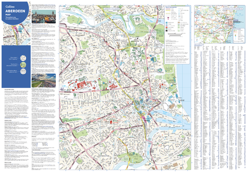
Collins Aberdeen Map
Collins
With clear mapping and a high level of detail, explore Aberdeen easily with maps from Collins. An ideal guide for tourists and residents alike, this map identifies many tourist attractions, places to stay, and cafes and restaurants, including the Aberdeen Maritime Museum and Duthie Park Winter Gardens. Extending from the central area to the airport and along the coast, this is an essential map for any visitors exploring Aberdeen.
Page Size: 32 x 22.25 in (810 x 560 mm)
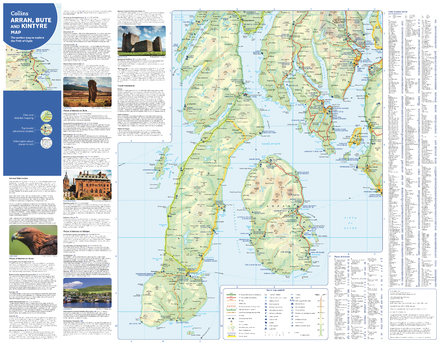
Collins Arran, Bute and Kintyre Map
Collins
With clear mapping and a high level of detail, explore Arran, Bute and Kintyre easily with maps from Collins. This map identifies tourist attractions and places to stay, as well as restaurants and tourist information sites, making it an essential map for any visitors or residents exploring the Firth of Clyde.
Page Size: 28.5 x 22.25 in (720 x 560 mm)
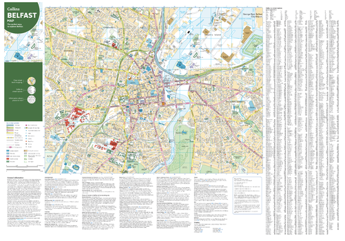
Collins Belfast Map
Collins
With clear mapping and a high level of detail, explore Belfast easily with maps from Collins. This map identifies tourist attractions, places to stay, and transport links, as well as restaurants and tourist information sites, making it an essential map for any visitors or residents exploring Northern Ireland’s Capital city.
Page Size: 32 x 22.25 in (810 x 560 mm)
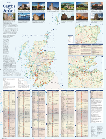
Collins Castles Map of Scotland
Collins
Pictorial map featuring over 700 castles and fortified houses. Includes an easy-to-use index listing visitor information and an attractive selection of photographs.
- Over 700 castles and fortifications
- Index comprises map references, the age and type of each castle, public access details, Historic Scotland and National Trust for Scotland ownership, notable grounds and gardens, telephone numbers and websites
- Highlights Scotland’s finest castles, castellated mansions and also the best castles for children
- Attractive photographs of a selection of castles, together with a brief account of their history
- A brief history of Scottish castles and information on architectural types and periods of construction
- Internet links and suggested reading for further information
Page Size: 30.75 x 40 in (775 x 1015 mm)
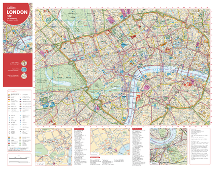
Collins Central London Map
Collins
With clear mapping and a high level of detail, explore central London easily with maps from Collins. From Regent’s Park in the north to Kennington in the south, Kensington Garden’s in the west to Tower Bridge in the east. Including theatres, shops, underground stations and congestion zone boundaries, this inclusive map is the perfect guide to central London for tourists and residents alike.
Page Size: 28.5 x 22.25 in (720 x 560 mm)
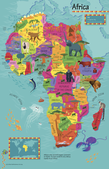
Collins Children's Africa Wall Map
Collins
This highly illustrated pictorial map is designed to take children on a journey of discovery around the countries of Africa. The mapping is clear, colourful and highly informative and shows countries and capital cities. Stunning illustrations are used to depict themes such as national emblems, customs, food, birds, animals, buildings and sports to help younger readers gain an understanding of peoples around the world. The perfect introduction to maps for 4-8 year olds. Illustrated by Steve Evans.
Page Size: 19.5 x 30 in (492 x 760 mm)
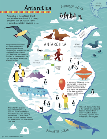
Collins Children's Antarctica Wall Map
Collins
This highly illustrated pictorial map is designed to take children on a journey of discovery around Antarctica. The mapping is clear, colourful and highly informative. Stunning illustrations are used to depict themes such as national emblems, customs, food, birds, animals, buildings and sports to help younger readers gain an understanding of peoples around the world. The perfect introduction to maps for 4-8 year olds. Illustrated by Steve Evans.
Page Size: 15 x 19.5 in (380 x 492 mm)
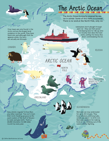
Collins Children's Arctic Wall Map
Collins
This highly illustrated pictorial map is designed to take children on a journey of discovery around the Arctic. The mapping is clear, colourful and highly informative. Stunning illustrations are used to depict themes such as national emblems, customs, food, birds, animals, buildings and sports to help younger readers gain an understanding of peoples around the world. The perfect introduction to maps for 4-8 year olds. Illustrated by Steve Evans.
Page Size: 15 x 19.5 in (380 x 492 mm)
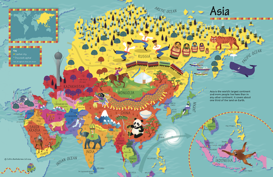
Collins Children's Asia Wall Map
Collins
This highly illustrated pictorial map is designed to take children on a journey of discovery around the countries of Asia. The mapping is clear, colourful and highly informative and shows countries and capital cities. Stunning illustrations are used to depict themes such as national emblems, customs, food, birds, animals, buildings and sports to help younger readers gain an understanding of peoples around the world. The perfect introduction to maps for 4-8 year olds. Illustrated by Steve Evans.
Page Size: 30 x 19.5 in (760 x 492 mm)
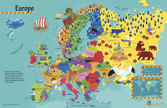
Collins Children's Europe Wall Map
Collins
This highly illustrated pictorial map is designed to take children on a journey of discovery around the countries of Europe. The mapping is clear, colourful and highly informative and shows countries and capital cities. Stunning illustrations are used to depict themes such as national emblems, customs, food, birds, animals, buildings and sports to help younger readers gain an understanding of peoples around the world. The perfect introduction to maps for 4-8 year olds. Illustrated by Steve Evans.
Page Size: 30 x 19.5 in (760 x 492 mm)
No search results