


MapSherpa Catalog

Chippewa Flowage
Mapping Specialists
An Attractive map of the lake showing a visual 3D representation of the lake bottom. Includes boat launches, rock area and vegetation. Land area is high resolution aerial imagery.
Page Size: 37.25 x 27.75 in (943 x 705 mm)
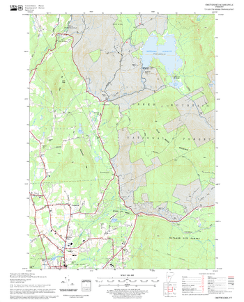
Chittenden Quadrangle, New Hampshire-Vermont
United States Department of Agriculture Forest Service
United States Forestry Service topographical map of Chittenden, New Hampshire-Vermont
Page Size: 21.75 x 27 in (552 x 686 mm)
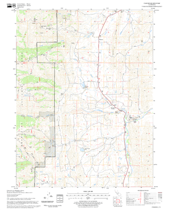
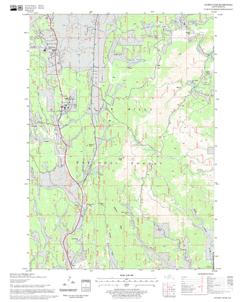
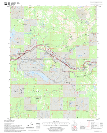
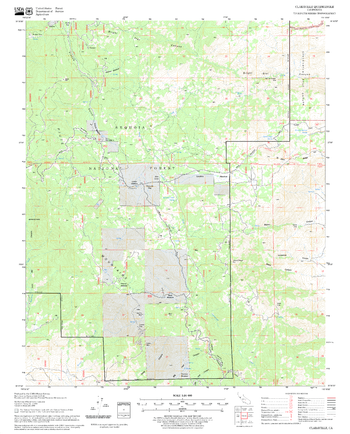
Chrome Quadrangle, California
United States Department of Agriculture Forest Service
United States Department of Agriculture Forestry Service topographical map of Chrome, Mendocino National Forest, California.
Page Size: 21.75 x 27 in (552 x 686 mm)
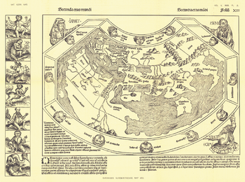
Chronicon Nurembergense 1493 Map - Published 1893
National Geographic
Originally produced only in woodcut form, the Chronicon Nurembergense Map of 1493 was published in National Geographic Magazine in April 1893, just five years after the Society's inception. This Latin version was first published in April of 1493, followed by a German version in December of the same year. A perfect companion to the world map by Johannes Ruysch.
Page Size: 21.75 x 16 in (547 x 406 mm)
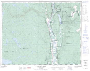
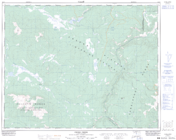
Chu Chua Creek - 92 P/8 - British Columbia
Natural Resources Canada
Canadian topographic map of Chu Chua Creek, British Columbia. NTS sheet 092P08 Edition 3.
Page Size: 31.75 x 25.25 in (804 x 641 mm)
Churn Creek - 92 O/7 - British Columbia
Natural Resources Canada
Canadian topographic map of Churn Creek, British Columbia. NTS sheet 092O07 Edition 3.
Page Size: 31.5 x 25.25 in (800 x 637 mm)
Cicero Peak Quadrangle, South Dakota
United States Department of Agriculture Forest Service
United States Department of Agriculture Forestry Service topographical map of Cicero Peak, Black Hills National Forest, South Dakota.
Page Size: 21.75 x 27 in (552 x 686 mm)

Cisco Chain
Mapping Specialists
An Attractive map of the lake showing a visual 3D representation of the lake bottom. Includes boat launches, rock area and vegetation. Land area is high resolution aerial imagery.
Page Size: 27.75 x 37.25 in (705 x 943 mm)
Cisco Grove Quadrangle, California
United States Department of Agriculture Forest Service
United States Department of Agriculture Forestry Service topographical map of Cisco Grove, Tahoe National Forest, California.
Page Size: 21.75 x 27 in (552 x 686 mm)
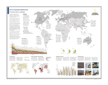
City Characteristics: A Diverse Urban Landscape - Atlas of the World, 10th Edition
National Geographic
Mapping Cities by Population; Global Cities Index; City Prosperity Index; Proportion of Population Living in Slum Areas; Urbanization and Geography; Planning for Prosperity
Page Size: 28 x 22 in (711 x 559 mm)
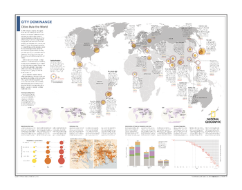
City Dominance: Cities Rule the World - Atlas of the World, 10th Edition
National Geographic
Gaining Numbers; Tracking Leading Cities; Identifying City Sizes; Defining a City; Distribution of Cities by Population and Area; Growing Megacities
Page Size: 28 x 22 in (711 x 559 mm)
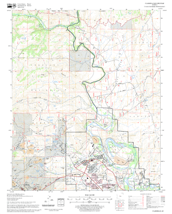
Claraville Quadrangle, California
United States Department of Agriculture Forest Service
United States Department of Agriculture Forestry Service topographical map of Claraville, Sequoia National Forest, California.
Page Size: 21.75 x 27 in (552 x 686 mm)
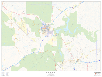
Clark County, Nevada
MapSherpa
This map of Clark County, Nevada shows regional level information. Base map features include highways and major roads with highway numbering and high level land use such as parks and recreation areas.
Page Size: 48 x 36 in (1219 x 914 mm)
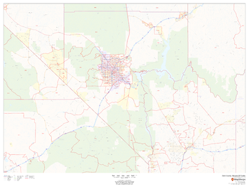
Clark County, Nevada ZIP Codes
MapSherpa
This map of Clark County, Nevada shows ZIP code areas overlaid on a road map. Ideal for planning of deliveries, home services, sales territories, real estate and much more. Base map features include all roads with major roads and highways labelled; neighborhood names; and high level land use such as parks and recreation areas, industrial areas and hospital campuses.
Page Size: 48 x 36 in (1219 x 914 mm)
Clarkdale Quadrangle, Arizona
United States Department of Agriculture Forest Service
United States Department of Agriculture Forestry Service topographical map of Clarkdale, Coconino National Forest, Arizona.
Page Size: 21.75 x 27 in (552 x 686 mm)
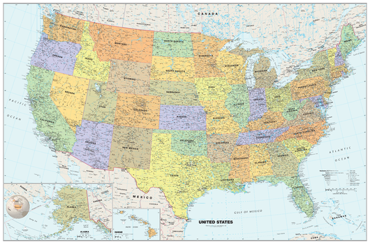
Classic USA Wall Map
Globe Turner
Perfect for home, business, or school, this Classic USA Wall Map combines warm, attractive colors with high-detailed cartography. Details on this United States Wall Map include: state boundaries and capitals along with other major cities and towns; major physical features such as mountain ranges and major mountain peaks; major water features such as oceans, seas, gulfs, and rivers; the Interstate highway system and other major roads; and all National Parks as well as other large National Park Service sites. Special features include traditional, blue-colored oceans and a white decorative border. This map of the United States uses the Albers Equal Area projection.
Page Size: 50 x 33 in (1270 x 838 mm)
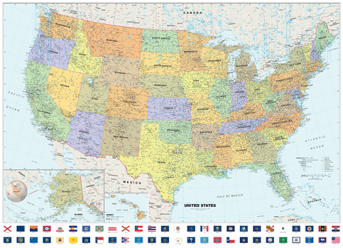
Classic USA Wall Map with Flags
Globe Turner
Perfect for home, business, or school, this Classic USA Wall Map with Flags combines warm, attractive colors with high-detailed cartography. Details on this United States Wall Map include: state boundaries and capitals along with other major cities and towns; major physical features such as mountain ranges and major mountain peaks; major water features such as oceans, seas, gulfs, and rivers; the Interstate highway system and other major roads; all National Parks as well as other large National Park Service sites; and flags of all 50 states and the District of Columbia. Special features include traditional, blue-colored oceans and a white decorative border. This map of the United States uses the Albers Equal Area projection.
Page Size: 50 x 36.25 in (1270 x 921 mm)
Classic World Map
Maps International
A popular classic world map with its artistic classic-style muted tones; it looks simply stunning and rather elegant. Splendid wall map art of the world in vintage style. Complete with political detail (countries shaded in different tones), country boundaries and cities shown.
Page Size: 53.75 x 33.25 in (1364 x 844 mm)

Classic World Map
Maps International
This popular world classic map looks stunning and elegant with its artistic, classic-style muted tones.
Map details: Beautiful world wall map art in vintage style. Complete with political details (countries shaded in different tones), international borders and cities.
Map uses: This vintage world map is perfect for giving your home or office an exclusive feel. The vintage world map wall art also adds a touch of luxury to the home, making it ideal for more discerning customers.
Page Size: 47 x 33.25 in (1189 x 841 mm)

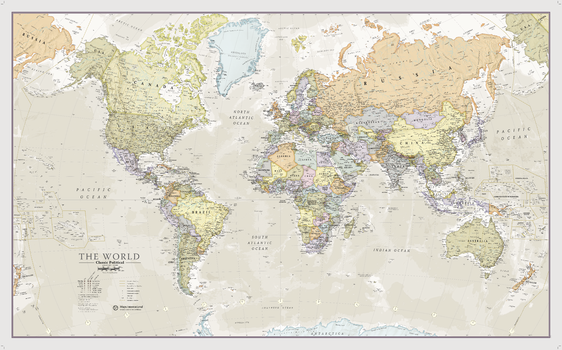
Classic World Map
Maps International
This popular world classic map looks stunning and elegant with its artistic, classic-style muted tones.
Map details: Beautiful world wall map art in vintage style. Complete with political details (countries shaded in different tones), international borders and cities.
Map uses: This vintage world map is perfect for giving your home or office an exclusive feel. The vintage world map wall art also adds a touch of luxury to the home, making it ideal for more discerning customers.
Page Size: 48 x 36 in (1219 x 914 mm)
No search results