


MapSherpa Catalog
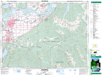
Chilliwack - 92 H/4 - British Columbia
Natural Resources Canada
Canadian topographic map of Chilliwack, British Columbia. NTS sheet 092H04 Edition 9.
Page Size: 34.75 x 26 in (880 x 659 mm)
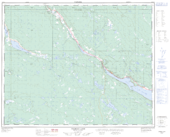
Chimney Lake - 92 P/13 - British Columbia
Natural Resources Canada
Canadian topographic map of Chimney Lake, British Columbia. NTS sheet 092P13 Edition 2.
Page Size: 31.5 x 25.5 in (795 x 642 mm)
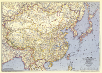
China - Published 1945
National Geographic
When this map was published in June of 1945, World War II was about to come to an end, but China would see little relief. With their enemy Japan defeated, China was plunged into a four-year civil war. This historic map, which accompanied the article "China Fights Erosion with U.S. Aid," is a wonderful companion to the China maps of 1912, 1964, and 1991.
Page Size: 36.75 x 26.5 in (932 x 668 mm)
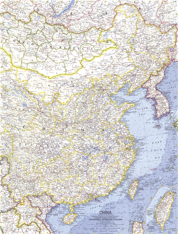
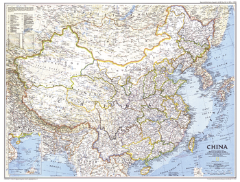
China - Published 1964
National Geographic
China exploded its first atomic bomb just weeks before this map was published in November 1964. With thousands of geographic features and accompanying place names, this map offers a very detailed look at the most populated country in the world.
Page Size: 19 x 25 in (480 x 630 mm)
China - Published 1991
National Geographic
This detailed map of China displays the political boundaries of the most populous nation in the world. Published in July 1991 as a companion to the article entitled "China's Youth Wait for Tomorrow."
Page Size: 29 x 22 in (733 x 555 mm)
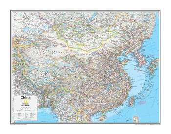
China - Atlas of the World, 10th Edition
National Geographic
China, Mongolia, Taiwan
Page Size: 28 x 22 in (711 x 559 mm)
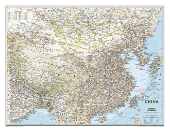
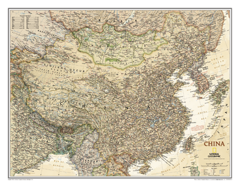
China Classic
National Geographic
This detailed political map of China accurately shows locations of provincial boundaries, cities and towns, major highways and roads, rivers and waterways, and other geographic features.
Page Size: 30.5 x 23.75 in (770 x 600 mm)
China Coast - Atlas of the World, 10th Edition
National Geographic
null
Page Size: 28 x 22 in (711 x 559 mm)
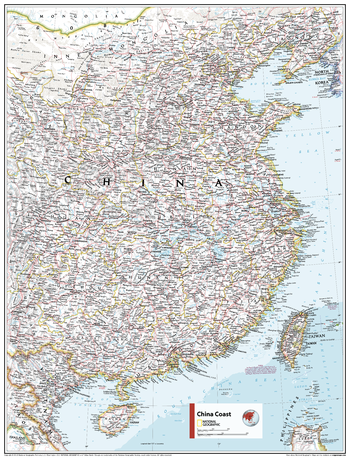
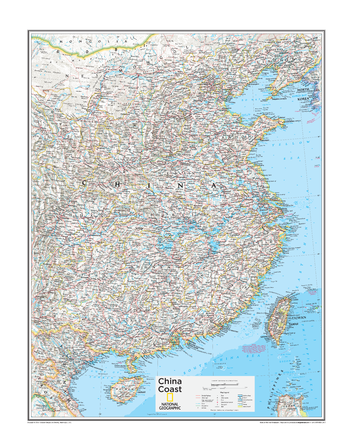
China Coast - Atlas of the World, 11th Edition
National Geographic
This China coast map of physical and political features can fit in any space. Showcasing the region in stunning detail with state-of-the-art cartographic techniques delivering accuracy and exceptional quality, the innovative and engaging design makes the content easily accessible and user-friendly.
Ideal for classrooms with an emphasis on teaching geography or environmental themes. The inclusion of physical features gives your students a genuine feel for how our world appears.
This map uses a bright, easy to read color palette featuring blue oceans and stunning shaded relief that has been featured on National Geographic wall maps for over 75 years.It is drawn in the Lambert Conformal Conic projection, which seats a cone over the sphere of the Earth and projects the surface conformally onto the cone.
Names of geographic features are carefully placed on the map to maintain legibility.
This map is found in National Geographic's 11th Edition World Atlas and is now available as a stand alone product.
Page Size: 24 x 31.5 in (610 x 798 mm)

China Coast - Atlas of the World, 11th Edition - Compact
National Geographic
This China coast map of physical and political features can fit in any space. Showcasing the region in stunning detail with state-of-the-art cartographic techniques delivering accuracy and exceptional quality, the innovative and engaging design makes the content easily accessible and user-friendly.
Ideal for classrooms with an emphasis on teaching geography or environmental themes. The inclusion of physical features gives your students a genuine feel for how our world appears.
This map uses a bright, easy to read color palette featuring blue oceans and stunning shaded relief that has been featured on National Geographic wall maps for over 75 years.It is drawn in the Lambert Conformal Conic projection, which seats a cone over the sphere of the Earth and projects the surface conformally onto the cone.
Names of geographic features are carefully placed on the map to maintain legibility.
This map is found in National Geographic's 11th Edition World Atlas and is now available as a stand alone product.
Page Size: 16.25 x 21.5 in (413 x 540 mm)
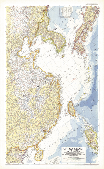
China Coast and Korea - Published 1953
National Geographic
This detailed map of the China coast and Korea was published in October 1953, just months after the end of the Korean War. It accompanied the article "Our Navy in the Far East."
Page Size: 26 x 42.5 in (659 x 1074 mm)
China Executive
National Geographic
This elegant, richly colored antique-style map of China features the incredible cartographic detail that is the trademark of National Geographic quality.<br><br>The China Executive wall map accurately shows locations of provincial boundaries, cities and towns, major highways and roads, rivers and waterways, and other geographic features.
Page Size: 30.5 x 23.75 in (770 x 600 mm)
China Hat Quadrangle, Oregon
United States Department of Agriculture Forest Service
United States Department of Agriculture Forestry Service topographical map of China Hat, Deschutes National Forest, Oregon.
Page Size: 21.75 x 27 in (552 x 686 mm)
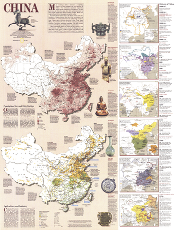
China History - Published 1991
National Geographic
Packed with both historical, economic, and social data, this work includes two large maps detailing China's population density and industry and agriculture, as well as six smaller maps illustrating historical periods. A companion to the physical and political map of China included in this July 1991 issue of National Geographic, it also accompanied an article entitled "China's Youth Wait for Tomorrow."
Page Size: 22 x 29 in (557 x 731 mm)
China Wall Map - Chinese - Extra Large
Kartographia
This Chinese-language physical wall map of China shows the varied terrain of the country. Place names are also provided in Roman transcription (pinyin). Features identified on the map include: UNESCO World cultural heritage sites, reserves and national parks, historical and natural monuments, archeological monuments, and religious buildings.
Page Size: 62.5 x 43 in (1586 x 1086 mm)
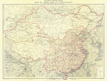
China and Its Territories - Published 1912
National Geographic
Discover China at a turning point in its history. In 1912, over 2,000 years of imperial rule ended as the last emperor of the Qing dynasty abdicated and the Republic of China was born. This beautiful map appeared in National Geographic Magazine in October of 1912, along with three articles on China including "The Most Extraordinary City in the World: Notes on Lhasa - The Mecca of the Buddhist Faith." A perfect companion for the maps of China published in 1945, 1964, and 1991.
Page Size: 22.75 x 17.25 in (577 x 436 mm)
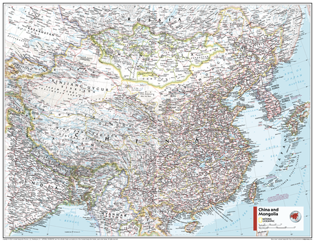
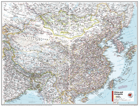
China and Mongolia - Atlas of the World, 11th Edition
National Geographic
This China and Mongolia map of physical and political features can fit in any space. Showcasing the countries in stunning detail with state-of-the-art cartographic techniques delivering accuracy and exceptional quality, the innovative and engaging design makes the content easily accessible and user-friendly.
Ideal for classrooms with an emphasis on teaching geography or environmental themes. The inclusion of physical features gives your students a genuine feel for how our world appears.
This map uses a bright, easy to read color palette featuring blue oceans and stunning shaded relief that has been featured on National Geographic wall maps for over 75 years. It is drawn in Conic projection, in which an area of the earth is projected onto a cone whose vertex is usually above one of the poles, then unrolled onto a flat surface.
Names of geographic features are carefully placed on the map to maintain legibility.
This map is found in National Geographic's 11th Edition World Atlas and is now available as a stand alone product.
Page Size: 31.5 x 24 in (798 x 610 mm)
China and Mongolia - Atlas of the World, 11th Edition - Compact
National Geographic
This China and Mongolia map of physical and political features can fit in any space. Showcasing the countries in stunning detail with state-of-the-art cartographic techniques delivering accuracy and exceptional quality, the innovative and engaging design makes the content easily accessible and user-friendly.
Ideal for classrooms with an emphasis on teaching geography or environmental themes. The inclusion of physical features gives your students a genuine feel for how our world appears.
This map uses a bright, easy to read color palette featuring blue oceans and stunning shaded relief that has been featured on National Geographic wall maps for over 75 years. It is drawn in Conic projection, in which an area of the earth is projected onto a cone whose vertex is usually above one of the poles, then unrolled onto a flat surface.
Names of geographic features are carefully placed on the map to maintain legibility.
This map is found in National Geographic's 11th Edition World Atlas and is now available as a stand alone product.
Page Size: 21.5 x 16.25 in (540 x 413 mm)
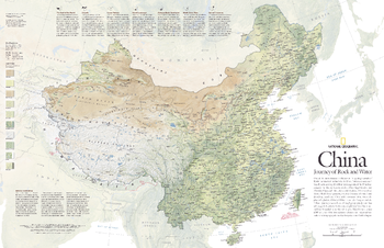
China, Journey of Rock and Water - Published 2008
National Geographic
One of the most dramatic collisions in the geologic annals of Earth transformed the land that is now China. India's tectonic crash into Eurasia starting 35 million years ago raised the Himalaya and lifted the plateau of Tibet. The new elevations shifted climate patterns, created deserts to the north and drenched southeast China with monsoon rains. This detailed physical map of China depicts the country's wide range of land cover including forests, grasslands, row crops, bare ground, deserts, and more. Published in May 2008, this map was half of a two-map set with "The Forbidden City."
Page Size: 31.25 x 20.25 in (789 x 510 mm)
Chinook Mountain Quadrangle, Idaho
United States Department of Agriculture Forest Service
United States Department of Agriculture Forestry Service topographical map of Chinook Mountain, Salmon-Chalis National Forest, Idaho.
Page Size: 21.75 x 27 in (552 x 686 mm)
No search results