


MapSherpa Catalog
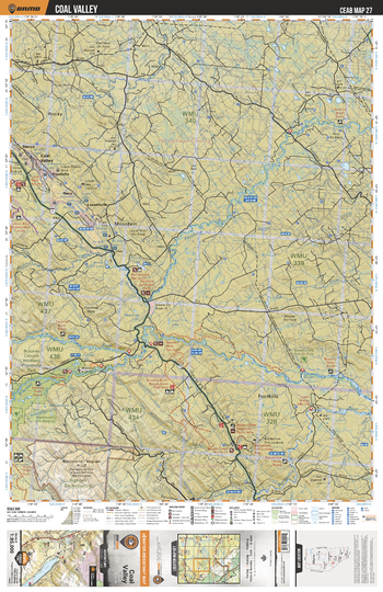
CEAB27 Coal Valley - Central Alberta Topo
Backroad Mapbooks
This recreation topographic map for Coal Valley highlights all the logging and resource roads, multi-use trails for hikers, mountain bikers, horseback riders, cross-country skiers and snowshoers, motorized trails for ATVers and snowmobiles, fishing lakes and rivers, recreation areas, campgrounds, day-use areas, viewpoints, backcountry campsites, work camps, oil & gas sites, backcountry huts and cabins and more. No other map for the area provides you with this level of recreational or topographic detail. Covering 3,040 km2 (1,175 mi2) in total, this 1:85,000 scale map measures 48 x 63.5 km (30 x 39.5 mi). Special features include enhanced oil & gas data plus countless roads, trails and recreational Points of Interest. This map includes Pembina River, Brazeau River, Blackstone River, Fairfax Lake, Lovettville, Reco, Foothills, Coal Valley, Sterco, Cardinal River and more!
Page Size: 24 x 37 in (610 x 940 mm)
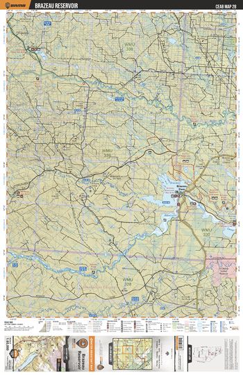
CEAB28 Brazeau Reservoir - Central Alberta Topo
Backroad Mapbooks
This recreation topographic map for Brazeau Reservoir highlights all the logging and resource roads, multi-use trails for hikers, mountain bikers, horseback riders, cross-country skiers and snowshoers, motorized trails for ATVers and snowmobiles, fishing lakes and rivers, recreation areas, campgrounds, day-use areas, viewpoints, backcountry campsites, work camps, oil & gas sites, backcountry huts and cabins and more. No other map for the area provides you with this level of recreational or topographic detail. Covering 3,040 km2 (1,175 mi2) in total, this 1:85,000 scale map measures 48 x 63.5 km (30 x 39.5 mi). Special features include enhanced oil & gas data plus countless roads, trails and recreational Points of Interest. This map includes Brazeau Reservoir, Brazeau Canal, Brazeau River, Pembina River, Wolf Lake, Brazeau Dam, Nordegg River, Elk River and more!
Page Size: 24 x 37 in (610 x 940 mm)
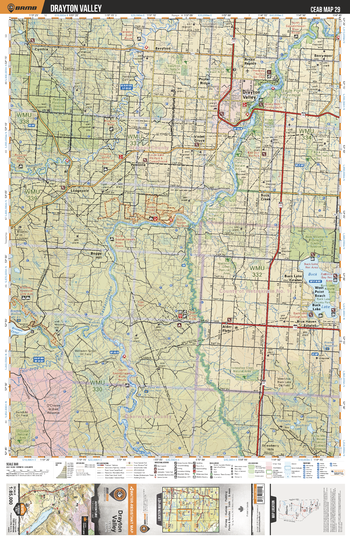
CEAB29 Drayton Valley - Central Alberta Topo
Backroad Mapbooks
This recreation topographic map for Drayton Valley highlights all the logging and resource roads, multi-use trails for hikers, mountain bikers, horseback riders, cross-country skiers and snowshoers, motorized trails for ATVers and snowmobiles, fishing lakes and rivers, recreation areas, campgrounds, day-use areas, viewpoints, backcountry campsites, work camps, oil & gas sites, backcountry huts and cabins and more. No other map for the area provides you with this level of recreational or topographic detail. Covering 3,040 km2 (1,175 mi2) in total, this 1:85,000 scale map measures 48 x 63.5 km (30 x 39.5 mi). Special features include enhanced oil & gas data plus countless roads, trails and recreational Points of Interest. This map includes Buck Lake, Alder Flats, Brazeau River, North Saskatchewan River, Drayton Valley, Eagle Point Prov Park, Pembina River, Pembina Grazing Reserve, Lodgepole, Pembina and more!
Page Size: 24 x 37 in (610 x 940 mm)
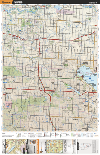
CEAB30 Winfield - Central Alberta Topo
Backroad Mapbooks
This recreation topographic map for Winfield highlights all the logging and resource roads, multi-use trails for hikers, mountain bikers, horseback riders, cross-country skiers and snowshoers, motorized trails for ATVers and snowmobiles, fishing lakes and rivers, recreation areas, campgrounds, day-use areas, viewpoints, backcountry campsites, work camps, oil & gas sites, backcountry huts and cabins and more. No other map for the area provides you with this level of recreational or topographic detail. Covering 3,040 km2 (1,175 mi2) in total, this 1:85,000 scale map measures 48 x 63.5 km (30 x 39.5 mi). Special features include enhanced oil & gas data plus countless roads, trails and recreational Points of Interest. This map includes Pigeon Lake, Buck Mountain Grazing Reserve, Town Lake, Thorsby, Benton, Coyote Lake Natural Area, Lindale, Warburg, Battle Lake, Twin Lakes and more!
Page Size: 24 x 37 in (610 x 940 mm)
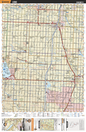
CEAB31 Leduc - Central Alberta Topo
Backroad Mapbooks
This recreation topographic map for Leduc highlights all the logging and resource roads, multi-use trails for hikers, mountain bikers, horseback riders, cross-country skiers and snowshoers, motorized trails for ATVers and snowmobiles, fishing lakes and rivers, recreation areas, campgrounds, day-use areas, viewpoints, backcountry campsites, work camps, oil & gas sites, backcountry huts and cabins and more. No other map for the area provides you with this level of recreational or topographic detail. Covering 3,040 km2 (1,175 mi2) in total, this 1:85,000 scale map measures 48 x 63.5 km (30 x 39.5 mi). Special features include enhanced oil & gas data plus countless roads, trails and recreational Points of Interest. This map includes Pigeon Lake, Bearhills Lake, Wizard Lake, Saunders Lake, Coal Lake, Wetaskiwin, Hobbema, Leduc, Nisku, Devon and more!
Page Size: 24 x 37 in (610 x 940 mm)
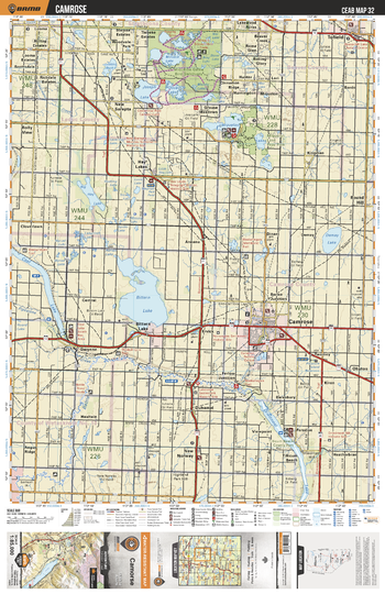
CEAB32 Camrose - Central Alberta Topo
Backroad Mapbooks
This recreation topographic map for Camrose highlights all the logging and resource roads, multi-use trails for hikers, mountain bikers, horseback riders, cross-country skiers and snowshoers, motorized trails for ATVers and snowmobiles, fishing lakes and rivers, recreation areas, campgrounds, day-use areas, viewpoints, backcountry campsites, work camps, oil & gas sites, backcountry huts and cabins and more. No other map for the area provides you with this level of recreational or topographic detail. Covering 3,040 km2 (1,175 mi2) in total, this 1:85,000 scale map measures 48 x 63.5 km (30 x 39.5 mi). Special features include enhanced oil & gas data plus countless roads, trails and recreational Points of Interest. This map includes Bittern Lake, Driedmeat Lake, Coal Lake, Battle River, Miquelon Lakes, Joseph Lake, Tofield, Camrose, New Norway, Hay Lakes and more!
Page Size: 24 x 37 in (610 x 940 mm)
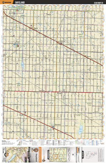
CEAB33 Daysland - Central Alberta Topo
Backroad Mapbooks
This recreation topographic map for Daysland highlights all the logging and resource roads, multi-use trails for hikers, mountain bikers, horseback riders, cross-country skiers and snowshoers, motorized trails for ATVers and snowmobiles, fishing lakes and rivers, recreation areas, campgrounds, day-use areas, viewpoints, backcountry campsites, work camps, oil & gas sites, backcountry huts and cabins and more. No other map for the area provides you with this level of recreational or topographic detail. Covering 3,040 km2 (1,175 mi2) in total, this 1:85,000 scale map measures 48 x 63.5 km (30 x 39.5 mi). Special features include enhanced oil & gas data plus countless roads, trails and recreational Points of Interest. This map includes Daysland, Bawlf, Holden, Ryley, Bruce, Shonts, Dodds, Black Nugget Lake Country Park, Gladstone, Woodglen, Wavy Lake and more!
Page Size: 24 x 37 in (610 x 940 mm)
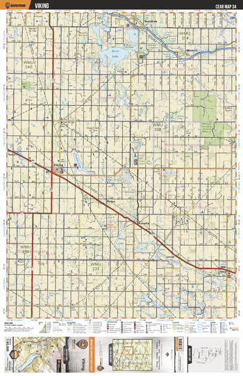
CEAB34 Viking - Central Alberta Topo
Backroad Mapbooks
This recreation topographic map for Viking highlights all the logging and resource roads, multi-use trails for hikers, mountain bikers, horseback riders, cross-country skiers and snowshoers, motorized trails for ATVers and snowmobiles, fishing lakes and rivers, recreation areas, campgrounds, day-use areas, viewpoints, backcountry campsites, work camps, oil & gas sites, backcountry huts and cabins and more. No other map for the area provides you with this level of recreational or topographic detail. Covering 3,040 km2 (1,175 mi2) in total, this 1:85,000 scale map measures 48 x 63.5 km (30 x 39.5 mi). Special features include enhanced oil & gas data plus countless roads, trails and recreational Points of Interest. This map includes Vernon Lake, Kinsella, Viking, Birch Lake, Thomas Lake, Hattie Lake, Irma, Minburn, Alice Lake, Camp Lake and more!
Page Size: 24 x 37 in (610 x 940 mm)
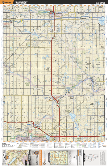
CEAB35 Wainwright - Central Alberta Topo
Backroad Mapbooks
This recreation topographic map for Wainwright highlights all the logging and resource roads, multi-use trails for hikers, mountain bikers, horseback riders, cross-country skiers and snowshoers, motorized trails for ATVers and snowmobiles, fishing lakes and rivers, recreation areas, campgrounds, day-use areas, viewpoints, backcountry campsites, work camps, oil & gas sites, backcountry huts and cabins and more. No other map for the area provides you with this level of recreational or topographic detail. Covering 3,040 km2 (1,175 mi2) in total, this 1:85,000 scale map measures 48 x 63.5 km (30 x 39.5 mi). Special features include enhanced oil & gas data plus countless roads, trails and recreational Points of Interest. This map includes Baxter Lakes, Wainwright, Battle River, Kenilworth Lake, Vermilion, Fabyan, Hope Valley, Auburndale, Bauer's Lake, Mannville and more!
Page Size: 24 x 37 in (610 x 940 mm)
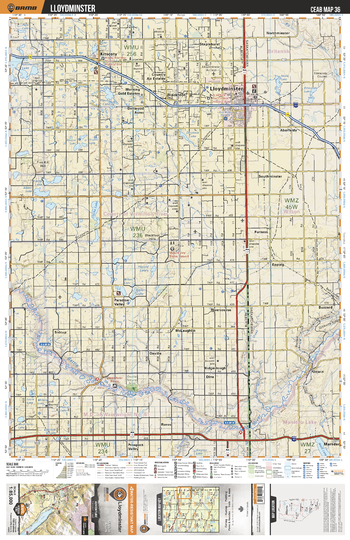
CEAB36 Lloydminster - Central Alberta Topo
Backroad Mapbooks
This recreation topographic map for Lloydminster highlights all the logging and resource roads, multi-use trails for hikers, mountain bikers, horseback riders, cross-country skiers and snowshoers, motorized trails for ATVers and snowmobiles, fishing lakes and rivers, recreation areas, campgrounds, day-use areas, viewpoints, backcountry campsites, work camps, oil & gas sites, backcountry huts and cabins and more. No other map for the area provides you with this level of recreational or topographic detail. Covering 3,040 km2 (1,175 mi2) in total, this 1:85,000 scale map measures 48 x 63.5 km (30 x 39.5 mi). Special features include enhanced oil & gas data plus countless roads, trails and recreational Points of Interest. This map includes Lloydminster, Battle River, Marsden, Kitscoty, Paradise Valley, Clarke Lake, Harold Lakes, Prospect Valley, Staplehurst, Mount Joy and more!
Page Size: 24 x 37 in (610 x 940 mm)
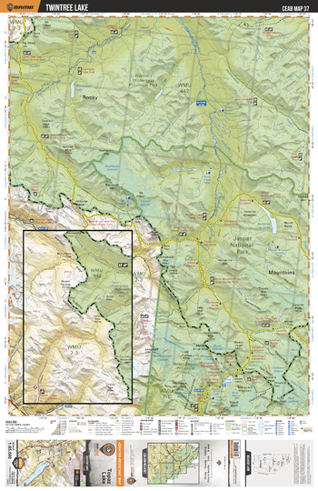
CEAB37 Twintree Lake - Central Alberta Topo
Backroad Mapbooks
This recreation topographic map for Twintree Lake highlights all the logging and resource roads, multi-use trails for hikers, mountain bikers, horseback riders, cross-country skiers and snowshoers, motorized trails for ATVers and snowmobiles, fishing lakes and rivers, recreation areas, campgrounds, day-use areas, viewpoints, backcountry campsites, work camps, oil & gas sites, backcountry huts and cabins and more. No other map for the area provides you with this level of recreational or topographic detail. Covering 3,040 km2 (1,175 mi2) in total, this 1:85,000 scale map measures 48 x 63.5 km (30 x 39.5 mi). Special features include enhanced oil & gas data plus countless roads, trails and recreational Points of Interest. This map includes Twintree Lake, Smoky River, Jackpine River, Mount Robson Provincial Park, Berg Lake, Willmore Wilderness Provincial Park and more!
Page Size: 24 x 37 in (610 x 940 mm)
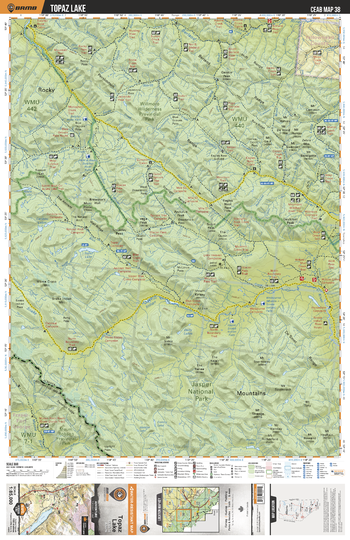
CEAB38 Topaz Lake - Central Alberta Topo
Backroad Mapbooks
This recreation topographic map for Topaz Lake highlights all the logging and resource roads, multi-use trails for hikers, mountain bikers, horseback riders, cross-country skiers and snowshoers, motorized trails for ATVers and snowmobiles, fishing lakes and rivers, recreation areas, campgrounds, day-use areas, viewpoints, backcountry campsites, work camps, oil & gas sites, backcountry huts and cabins and more. No other map for the area provides you with this level of recreational or topographic detail. Covering 3,040 km2 (1,175 mi2) in total, this 1:85,000 scale map measures 48 x 63.5 km (30 x 39.5 mi). Special features include enhanced oil & gas data plus countless roads, trails and recreational Points of Interest. This map includes Topaz Lake, Jasper National Park, Indian River, North Berland River, South Sulfur River, Wildhay River, Berland River and more!
Page Size: 24 x 37 in (610 x 940 mm)
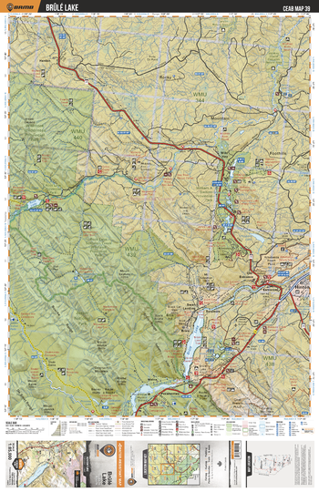
CEAB39 Brule Lake - Central Alberta Topo
Backroad Mapbooks
This recreation topographic map for Brule Lake highlights all the logging and resource roads, multi-use trails for hikers, mountain bikers, horseback riders, cross-country skiers and snowshoers, motorized trails for ATVers and snowmobiles, fishing lakes and rivers, recreation areas, campgrounds, day-use areas, viewpoints, backcountry campsites, work camps, oil & gas sites, backcountry huts and cabins and more. No other map for the area provides you with this level of recreational or topographic detail. Covering 3,040 km2 (1,175 mi2) in total, this 1:85,000 scale map measures 48 x 63.5 km (30 x 39.5 mi). Special features include enhanced oil & gas data plus countless roads, trails and recreational Points of Interest. This map includes Brule Lake, Rock Lake Solomon Creek Wildland Prov Park, Rock Lake, Hinton, Wild Hay, William A Switzer Prov Park, Miette, Pocahontas, Gregg Lake, Mount Solomon and more!
Page Size: 24 x 37 in (610 x 940 mm)
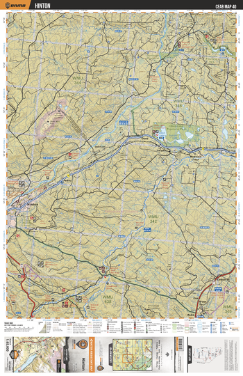
CEAB40 Hinton - Central Alberta Topo
Backroad Mapbooks
This recreation topographic map for Hinton highlights all the logging and resource roads, multi-use trails for hikers, mountain bikers, horseback riders, cross-country skiers and snowshoers, motorized trails for ATVers and snowmobiles, fishing lakes and rivers, recreation areas, campgrounds, day-use areas, viewpoints, backcountry campsites, work camps, oil & gas sites, backcountry huts and cabins and more. No other map for the area provides you with this level of recreational or topographic detail. Covering 3,040 km2 (1,175 mi2) in total, this 1:85,000 scale map measures 48 x 63.5 km (30 x 39.5 mi). Special features include enhanced oil & gas data plus countless roads, trails and recreational Points of Interest. This map includes Obed Lake Prov Park, Hinton, McLeod River, Emerson Lakes, Sundance Prov Park, Bryan Spur, Medicine Lodge, Dalehurst, Hargwen, Sucker Lake and more!
Page Size: 24 x 37 in (610 x 940 mm)
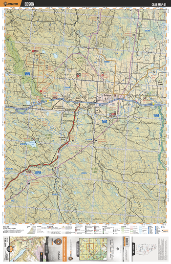
CEAB41 Edson - Central Alberta Topo
Backroad Mapbooks
This recreation topographic map for Edson highlights all the logging and resource roads, multi-use trails for hikers, mountain bikers, horseback riders, cross-country skiers and snowshoers, motorized trails for ATVers and snowmobiles, fishing lakes and rivers, recreation areas, campgrounds, day-use areas, viewpoints, backcountry campsites, work camps, oil & gas sites, backcountry huts and cabins and more. No other map for the area provides you with this level of recreational or topographic detail. Covering 3,040 km2 (1,175 mi2) in total, this 1:85,000 scale map measures 48 x 63.5 km (30 x 39.5 mi). Special features include enhanced oil & gas data plus countless roads, trails and recreational Points of Interest. This map includes Edson, Wolf Creek, Sundance Prov Park, McLeod River, Embarass River, Erith River, Big Eddy, Marlboro, Yates, Weald and more!
Page Size: 24 x 37 in (610 x 940 mm)
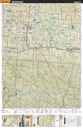
CEAB42 McLeod Valley - Central Alberta Topo
Backroad Mapbooks
This recreation topographic map for McLeod Valley highlights all the logging and resource roads, multi-use trails for hikers, mountain bikers, horseback riders, cross-country skiers and snowshoers, motorized trails for ATVers and snowmobiles, fishing lakes and rivers, recreation areas, campgrounds, day-use areas, viewpoints, backcountry campsites, work camps, oil & gas sites, backcountry huts and cabins and more. No other map for the area provides you with this level of recreational or topographic detail. Covering 3,040 km2 (1,175 mi2) in total, this 1:85,000 scale map measures 48 x 63.5 km (30 x 39.5 mi). Special features include enhanced oil & gas data plus countless roads, trails and recreational Points of Interest. This map includes McLeod River, Minnow Lake, Shag Lake Grazing Reserve, Nojack, MacKay, Beta Lake County Park, McLeod Valley, Bear Lake County Park, Carrot Creek, Long Lake County Park and more!
Page Size: 24 x 37 in (610 x 940 mm)
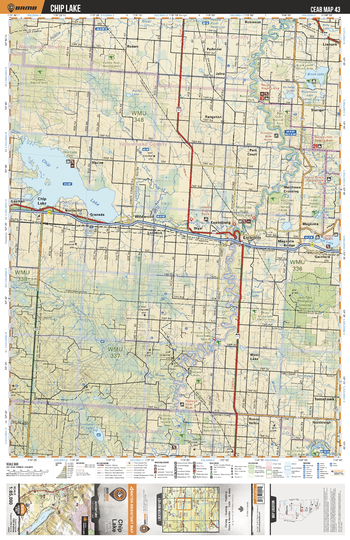
CEAB43 Chip Lake - Central Alberta Topo
Backroad Mapbooks
This recreation topographic map for Chip Lake highlights all the logging and resource roads, multi-use trails for hikers, mountain bikers, horseback riders, cross-country skiers and snowshoers, motorized trails for ATVers and snowmobiles, fishing lakes and rivers, recreation areas, campgrounds, day-use areas, viewpoints, backcountry campsites, work camps, oil & gas sites, backcountry huts and cabins and more. No other map for the area provides you with this level of recreational or topographic detail. Covering 3,040 km2 (1,175 mi2) in total, this 1:85,000 scale map measures 48 x 63.5 km (30 x 39.5 mi). Special features include enhanced oil & gas data plus countless roads, trails and recreational Points of Interest. This map includes Pembina River, Chip Lake, Entwistle, Magnolia, Isle Lake, Wildwood, Lobstick River, Brock Lake, Matthews Crossing, Moon Lake and more!
Page Size: 24 x 37 in (610 x 940 mm)
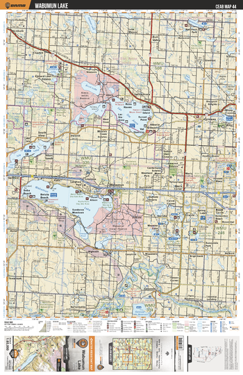
CEAB44 Wabamun - Central Alberta Topo
Backroad Mapbooks
This recreation topographic map for Wabamun highlights all the logging and resource roads, multi-use trails for hikers, mountain bikers, horseback riders, cross-country skiers and snowshoers, motorized trails for ATVers and snowmobiles, fishing lakes and rivers, recreation areas, campgrounds, day-use areas, viewpoints, backcountry campsites, work camps, oil & gas sites, backcountry huts and cabins and more. No other map for the area provides you with this level of recreational or topographic detail. Covering 3,040 km2 (1,175 mi2) in total, this 1:85,000 scale map measures 48 x 63.5 km (30 x 39.5 mi). Special features include enhanced oil & gas data plus countless roads, trails and recreational Points of Interest. This map includes Lac Ste Anne, Wabamun Lake, Wabamun, Mink Lake, North Saskatchewan River, Birch Lake, Isle Lake, Sturgeon Heights, Lessard Lake, Nakamun Lake and more!
Page Size: 24 x 37 in (610 x 940 mm)
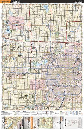
CEAB45 Edmonton - Central Alberta Topo
Backroad Mapbooks
This recreation topographic map for Edmonton highlights all the logging and resource roads, multi-use trails for hikers, mountain bikers, horseback riders, cross-country skiers and snowshoers, motorized trails for ATVers and snowmobiles, fishing lakes and rivers, recreation areas, campgrounds, day-use areas, viewpoints, backcountry campsites, work camps, oil & gas sites, backcountry huts and cabins and more. No other map for the area provides you with this level of recreational or topographic detail. Covering 3,040 km2 (1,175 mi2) in total, this 1:85,000 scale map measures 48 x 63.5 km (30 x 39.5 mi). Special features include enhanced oil & gas data plus countless roads, trails and recreational Points of Interest. This map includes Edmonton, St Albert, Spruce Grove, Sandy Lake, North Saskatchewan River, Beaumont, Morinville, Big Lake, Stony Plain, Manawan (Egg) Lake and more!
Page Size: 24 x 37 in (610 x 940 mm)
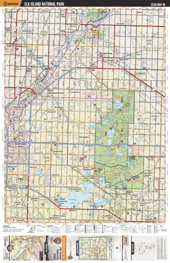
CEAB46 Elk Island National Park - Central Alberta Topo
Backroad Mapbooks
This recreation topographic map for Elk Island National Park highlights all the logging and resource roads, multi-use trails for hikers, mountain bikers, horseback riders, cross-country skiers and snowshoers, motorized trails for ATVers and snowmobiles, fishing lakes and rivers, recreation areas, campgrounds, day-use areas, viewpoints, backcountry campsites, work camps, oil & gas sites, backcountry huts and cabins and more. No other map for the area provides you with this level of recreational or topographic detail. Covering 3,040 km2 (1,175 mi2) in total, this 1:85,000 scale map measures 48 x 63.5 km (30 x 39.5 mi). Special features include enhanced oil & gas data plus countless roads, trails and recreational Points of Interest. This map includes Cooking Lake, Elk Island National Park, North Saskatchewan River, Fort Saskatchewan, Tawayik Lake, Gibbons, Sherwood Park, Bruderheim, Lamont, Astotin Lake and more!
Page Size: 24 x 37 in (610 x 940 mm)
No search results