


MapSherpa Catalog
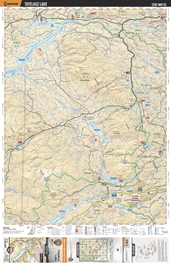
CCBC53 Tatelkuz Lake - Cariboo Chilcotin Coast BC Topo
Backroad Mapbooks
This recreation topographic map for the Tatelkuz Lake area highlights all the logging roads, trails and recreational Points of Interest including hunting, camping, hiking, mountain biking, canoeing, kayaking, backcountry skiing, wildlife viewing, ATVing, snowmobiling and more. No other map provides you with this level of recreational and topographic detail for the Homathko River area. Covering the Knewstubb Lake, Natalkuz Lake, Tatelkuz Lake, Kuyakuz Lake, Tsacha Lake, Kluskus Lakes, Top Lake, Big Bend Arm, Euchiniko Lakes, Kluskus Village and more, this map contains new features such as private land and labelled fish species. The 1:85,000 scale map covers 3,040 km2 (1,175 mi2), measuring 50 x 63.5 km (30 x 39.5 mi).
Page Size: 24 x 37 in (610 x 940 mm)
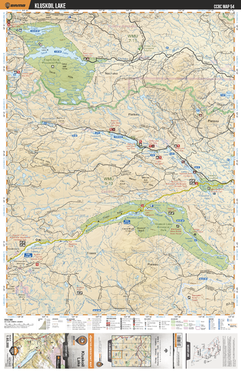
CCBC54 Kluskoil Lake - Cariboo Chilcotin Coast BC Topo
Backroad Mapbooks
This recreation topographic map for the Kluskoil Lake area highlights all the logging roads, trails and recreational Points of Interest including hunting, camping, hiking, mountain biking, canoeing, kayaking, backcountry skiing, wildlife viewing, ATVing, snowmobiling and more. No other map provides you with this level of recreational and topographic detail for the Homathko River area. Covering the Finger Tatuk Prov Park, Tatuk Lake, Finger Lake, Kluskoil Lake, Euchiniko Lakes, Kluskoil Lake Prov Park, Titetown Lake, Blackwater River, Euchiniko River, Batnuni Lake and more, this map contains new features such as private land and labelled fish species. The 1:85,000 scale map covers 3,040 km2 (1,175 mi2), measuring 50 x 63.5 km (30 x 39.5 mi).
Page Size: 24 x 37 in (610 x 940 mm)
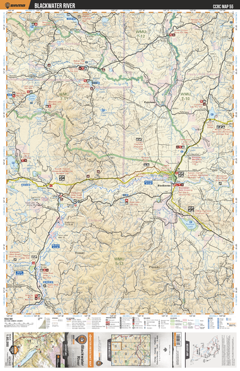
CCBC55 Blackwater River - Cariboo Chilcotin Coast BC Topo
Backroad Mapbooks
This recreation topographic map for the Blackwater River area highlights all the logging roads, trails and recreational Points of Interest including hunting, camping, hiking, mountain biking, canoeing, kayaking, backcountry skiing, wildlife viewing, ATVing, snowmobiling and more. No other map provides you with this level of recreational and topographic detail for the Homathko River area. Covering the Blackwater River, Punchaw Lake, Lintz Lake, Pantage Lake, Chilako River, Euchiniko River, Barton Lake, Nazko River, Blackwater, Boot Lake and more, this map contains new features such as private land and labelled fish species. The 1:85,000 scale map covers 3,040 km2 (1,175 mi2), measuring 50 x 63.5 km (30 x 39.5 mi).
Page Size: 24 x 37 in (610 x 940 mm)
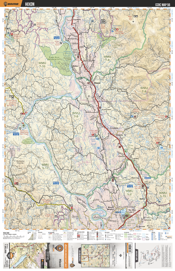
CCBC56 Hixon - Cariboo Chilcotin Coast BC Topo
Backroad Mapbooks
This recreation topographic map for the Hixon area highlights all the logging roads, trails and recreational Points of Interest including hunting, camping, hiking, mountain biking, canoeing, kayaking, backcountry skiing, wildlife viewing, ATVing, snowmobiling and more. No other map provides you with this level of recreational and topographic detail for the Homathko River area. Covering the Hixon, Ten Mile Lake, Fraser River Prov Park, Fraser River, Three Sisters Lakes Prov Park, Genevieve Lake, MacKenzie Lakes, Chubb Lake, Colebank, Crysdale and more, this map contains new features such as private land and labelled fish species. The 1:85,000 scale map covers 3,040 km2 (1,175 mi2), measuring 50 x 63.5 km (30 x 39.5 mi).
Page Size: 24 x 37 in (610 x 940 mm)
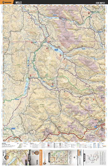
CCBC57 Wells - Cariboo Chilcotin Coast BC Topo
Backroad Mapbooks
This recreation topographic map for the Wells area highlights all the logging roads, trails and recreational Points of Interest including hunting, camping, hiking, mountain biking, canoeing, kayaking, backcountry skiing, wildlife viewing, ATVing, snowmobiling and more. No other map provides you with this level of recreational and topographic detail for the Homathko River area. Covering the Wells, Ahbau Lake, Pine Grove, Cottonwood, Stony Lake, Narrow Lake, Bowron River, Two Sisters Mtn, Cow Mtn, Willow River and more, this map contains new features such as private land and labelled fish species. The 1:85,000 scale map covers 3,040 km2 (1,175 mi2), measuring 50 x 63.5 km (30 x 39.5 mi).
Page Size: 24 x 37 in (610 x 940 mm)
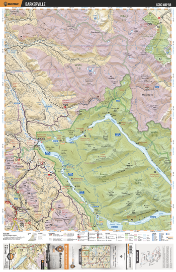
CCBC58 Barkerville - Cariboo Chilcotin Coast BC Topo
Backroad Mapbooks
This recreation topographic map for the Barkerville area highlights all the logging roads, trails and recreational Points of Interest including hunting, camping, hiking, mountain biking, canoeing, kayaking, backcountry skiing, wildlife viewing, ATVing, snowmobiling and more. No other map provides you with this level of recreational and topographic detail for the Homathko River area. Covering the Bowron Lake Prov Park, Barkerville, Swan Lake, Sandy Lake, Isaac Lake, Lanezi Lake, Bowron Lake, Indianpoint Lake, Bowron River, Ptarmingan Creek Prov Park and more, this map contains new features such as private land and labelled fish species. The 1:85,000 scale map covers 3,040 km2 (1,175 mi2), measuring 50 x 63.5 km (30 x 39.5 mi).
Page Size: 24 x 37 in (610 x 940 mm)
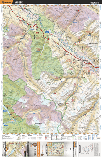
CCBC59 McBride - Cariboo Chilcotin Coast BC Topo
Backroad Mapbooks
This recreation topographic map for the McBride area highlights all the logging roads, trails and recreational Points of Interest including hunting, camping, hiking, mountain biking, canoeing, kayaking, backcountry skiing, wildlife viewing, ATVing, snowmobiling and more. No other map provides you with this level of recreational and topographic detail for the Homathko River area. Covering the West Twin Prov Park, Bowron Lake Prov Park, Cariboo River, Castle Creek, Fraser River, McBride, La Salle Lakes, Lamming Mills, Goat River, McKale River and more, this map contains new features such as private land and labelled fish species. The 1:85,000 scale map covers 3,040 km2 (1,175 mi2), measuring 50 x 63.5 km (30 x 39.5 mi).
Page Size: 24 x 37 in (610 x 940 mm)
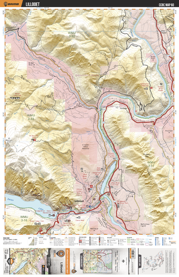
CCBC60 Lillooet - Cariboo Chilcotin Coast BC Topo
Backroad Mapbooks
This recreation topographic map for the Lillooet area highlights all the logging roads, trails and recreational Points of Interest including hunting, camping, hiking, mountain biking, canoeing, kayaking, backcountry skiing, wildlife viewing, ATVing, snowmobiling and more. No other map provides you with this level of recreational and topographic detail for the Homathko River area. Covering the Lillooet, Seton Lake Recreation Area and more, this map contains new features such as leased and private land.
Page Size: 24 x 37 in (610 x 940 mm)
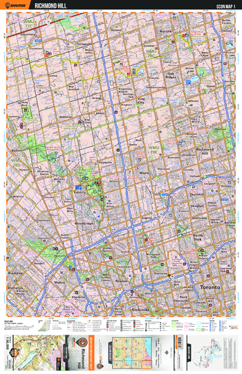
CCON01 Richmond Hill – Cottage Country Ontario Topo
Backroad Mapbooks
This recreation topographic map for Richmond Hill highlights all the logging/resource roads, hunting areas, fishing lakes & streams, campsites, paddling routes for canoeing and kayaking, wildlife viewing areas, multi-use trails for hiking, biking, horseback riding, cross-country skiing and snowshoeing, motorized trails for ATVing and snowmobiling & more. Covering 1,090 km2 (420 mi2), this 1:50,000 scale map measures 29 x 38 km (18 x 24 mi), providing you with more topographic and recreational detail for the Richmond Hill area than any other map on the market. New features include enhanced Crown land, countless new roads and trails and a wealth of recreational Points of Interest. Included on this map are Aurora, Bolton, Brampton, Etobicoke, King City, Malton, Mount Chinguacousy, Rexdale, Thornhill, North York, Oak Ridges, Richmond Hill, Toronto, Uplands Ski Centre and more!
Page Size: 24 x 37 in (610 x 940 mm)
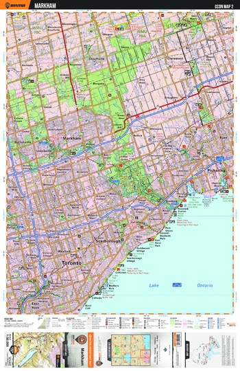
CCON02 Markham - Cottage Country Ontario Topo
Backroad Mapbooks
This recreation topographic map for Markham highlights all the logging/resource roads, hunting areas, fishing lakes & streams, campsites, paddling routes for canoeing and kayaking, wildlife viewing areas, multi-use trails for hiking, biking, horseback riding, cross-country skiing and snowshoeing, motorized trails for ATVing and snowmobiling & more. Covering 1,090 km2 (420 mi2), this 1:50,000 scale map measures 29 x 38 km (18 x 24 mi), providing you with more topographic and recreational detail for the Richmond Hill area than any other map on the market. New features include enhanced Crown land, countless new roads and trails and a wealth of recreational Points of Interest. Included on this map are Toronto, Markham, Scarborough, Claremont, East York, Pickering and more!
Page Size: 24 x 37 in (610 x 940 mm)
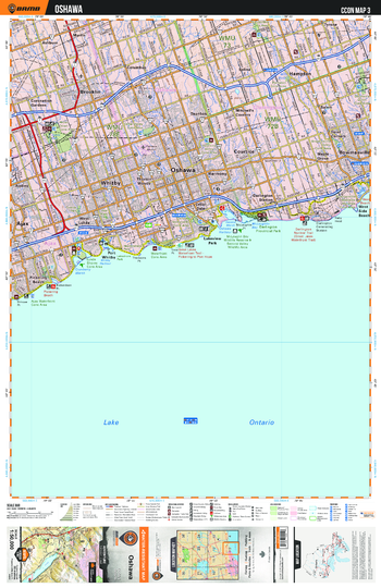
CCON03 Oshawa - Cottage Country Ontario Topo
Backroad Mapbooks
This recreation topographic map for Oshawa highlights all the logging/resource roads, hunting areas, fishing lakes & streams, campsites, paddling routes for canoeing and kayaking, wildlife viewing areas, multi-use trails for hiking, biking, horseback riding, cross-country skiing and snowshoeing, motorized trails for ATVing and snowmobiling & more. Covering 1,090 km2 (420 mi2), this 1:50,000 scale map measures 29 x 38 km (18 x 24 mi), providing you with more topographic and recreational detail for the Richmond Hill area than any other map on the market. New features include enhanced Crown land, countless new roads and trails and a wealth of recreational Points of Interest. Included on this map are Oshawa, Hampton, Brooklin, Darlington, Provincial, Ajax, Lakeview Park and more!
Page Size: 24 x 37 in (610 x 940 mm)
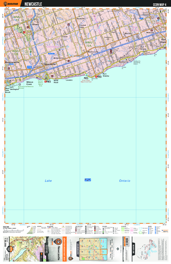
CCON04 Newcastle - Cottage Country Ontario Topo
Backroad Mapbooks
This recreation topographic map for Newcastle highlights all the logging/resource roads, hunting areas, fishing lakes & streams, campsites, paddling routes for canoeing and kayaking, wildlife viewing areas, multi-use trails for hiking, biking, horseback riding, cross-country skiing and snowshoeing, motorized trails for ATVing and snowmobiling & more. Covering 1,090 km2 (420 mi2), this 1:50,000 scale map measures 29 x 38 km (18 x 24 mi), providing you with more topographic and recreational detail for the Richmond Hill area than any other map on the market. New features include enhanced Crown land, countless new roads and trails and a wealth of recreational Points of Interest. Included on this map are Port Hope, Starkville, Orono, New Castle, Wesleyville, Newtonville, Port Britain, Bowmanville and more!
Page Size: 24 x 37 in (610 x 940 mm)
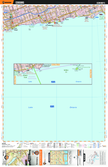
CCON05 Cobourg - Cottage Country Ontario Topo
Backroad Mapbooks
This recreation topographic map for Cobourg highlights all the logging/resource roads, hunting areas, fishing lakes & streams, campsites, paddling routes for canoeing and kayaking, wildlife viewing areas, multi-use trails for hiking, biking, horseback riding, cross-country skiing and snowshoeing, motorized trails for ATVing and snowmobiling & more. Covering 1,090 km2 (420 mi2), this 1:50,000 scale map measures 29 x 38 km (18 x 24 mi), providing you with more topographic and recreational detail for the Richmond Hill area than any other map on the market. New features include enhanced Crown land, countless new roads and trails and a wealth of recreational Points of Interest. Included on this map are Cobourg, Port Hope, Grafton, Dale, Coverdale, Lake Ontario, Brookside and more!
Page Size: 24 x 37 in (610 x 940 mm)
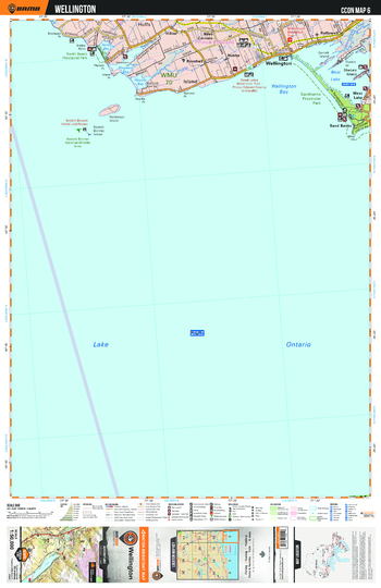
CCON06 Wellington - Cottage Country Ontario Topo
Backroad Mapbooks
This recreation topographic map for Wellington highlights all the logging/resource roads, hunting areas, fishing lakes & streams, campsites, paddling routes for canoeing and kayaking, wildlife viewing areas, multi-use trails for hiking, biking, horseback riding, cross-country skiing and snowshoeing, motorized trails for ATVing and snowmobiling & more. Covering 1,090 km2 (420 mi2), this 1:50,000 scale map measures 29 x 38 km (18 x 24 mi), providing you with more topographic and recreational detail for the Richmond Hill area than any other map on the market. New features include enhanced Crown land, countless new roads and trails and a wealth of recreational Points of Interest. Included on this map are Wellington, Sandbanks Provincial Park, Prince Edward, Hallowell, North Beach, Provincial, Hillier, Millenium Trail and more!
Page Size: 24 x 37 in (610 x 940 mm)
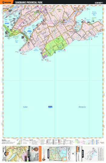
CCON07 Sandbanks Provincial Park - Cottage Country Ontario Topo
Backroad Mapbooks
This recreation topographic map for Sandbanks Provinical Park highlights all the logging/resource roads, hunting areas, fishing lakes & streams, campsites, paddling routes for canoeing and kayaking, wildlife viewing areas, multi-use trails for hiking, biking, horseback riding, cross-country skiing and snowshoeing, motorized trails for ATVing and snowmobiling & more. Covering 1,090 km2 (420 mi2), this 1:50,000 scale map measures 29 x 38 km (18 x 24 mi), providing you with more topographic and recreational detail for the Richmond Hill area than any other map on the market. New features include enhanced Crown land, countless new roads and trails and a wealth of recreational Points of Interest. Included on this map are Sandbanks Provincial Park, Millenium Waterfront Trail, Prince Edward, Lake Ontario, Black Creek, Sand Banks, Salmon Point and more!
Page Size: 24 x 37 in (610 x 940 mm)
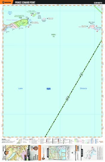
CCON08 Prince Edward Point - Cottage Country Ontario Topo
Backroad Mapbooks
This recreation topographic map for Prince Edward Point highlights all the logging/resource roads, hunting areas, fishing lakes & streams, campsites, paddling routes for canoeing and kayaking, wildlife viewing areas, multi-use trails for hiking, biking, horseback riding, cross-country skiing and snowshoeing, motorized trails for ATVing and snowmobiling & more. Covering 1,090 km2 (420 mi2), this 1:50,000 scale map measures 29 x 38 km (18 x 24 mi), providing you with more topographic and recreational detail for the Richmond Hill area than any other map on the market. New features include enhanced Crown land, countless new roads and trails and a wealth of recreational Points of Interest. Included on this map are Prince Edward, Bay, Point, Lake Ontario, Long Point, Timber Island, Provincial, Main Duck Island, False Ducks Islands and more!
Page Size: 24 x 37 in (610 x 940 mm)
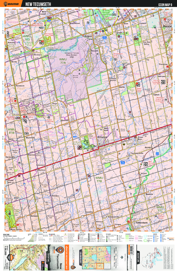
CCON09 New Tecumseth - Cottage Country Ontario Topo
Backroad Mapbooks
This recreation topographic map for New Tecumseth highlights all the logging/resource roads, hunting areas, fishing lakes & streams, campsites, paddling routes for canoeing and kayaking, wildlife viewing areas, multi-use trails for hiking, biking, horseback riding, cross-country skiing and snowshoeing, motorized trails for ATVing and snowmobiling & more. Covering 1,090 km2 (420 mi2), this 1:50,000 scale map measures 29 x 38 km (18 x 24 mi), providing you with more topographic and recreational detail for the Richmond Hill area than any other map on the market. New features include enhanced Crown land, countless new roads and trails and a wealth of recreational Points of Interest. Included on this map are New Tecumseth, Alliston, Tottenham, Ganaraska Trail, Sheldon, Borden, Baxter, Beeton and more!
Page Size: 24 x 37 in (610 x 940 mm)
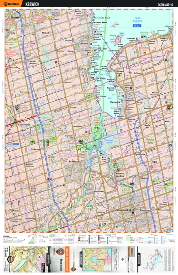
CCON10 Keswick - Cottage Country Ontario Topo
Backroad Mapbooks
This recreation topographic map for Keswick highlights all the logging/resource roads, hunting areas, fishing lakes & streams, campsites, paddling routes for canoeing and kayaking, wildlife viewing areas, multi-use trails for hiking, biking, horseback riding, cross-country skiing and snowshoeing, motorized trails for ATVing and snowmobiling & more. Covering 1,090 km2 (420 mi2), this 1:50,000 scale map measures 29 x 38 km (18 x 24 mi), providing you with more topographic and recreational detail for the Richmond Hill area than any other map on the market. New features include enhanced Crown land, countless new roads and trails and a wealth of recreational Points of Interest. Included on this map are Keswick, Lake Simcoe, New Market, Beach, Bradford, Cookstown, Bethesda, Cook's Bay and more!
Page Size: 24 x 37 in (610 x 940 mm)
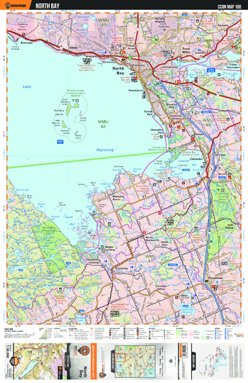
CCON100 North Bay - Cottage Country Ontario Topo
Backroad Mapbooks
This recreation topographic map for North Bay highlights all the logging/resource roads, hunting areas, fishing lakes & streams, campsites, paddling routes for canoeing and kayaking, wildlife viewing areas, multi-use trails for hiking, biking, horseback riding, cross-country skiing and snowshoeing, motorized trails for ATVing and snowmobiling & more. Covering 1,090 km2 (420 mi2), this 1:50,000 scale map measures 29 x 38 km (18 x 24 mi), providing you with more topographic and recreational detail for the Richmond Hill area than any other map on the market. New features include enhanced Crown land, countless new roads and trails and a wealth of recreational Points of Interest. Included on this map are North Bay, Nipissing, Powassen, Lake Nipissing, South Bay Provincial Park, Trans Canada Trail and more!
Page Size: 24 x 37 in (610 x 940 mm)
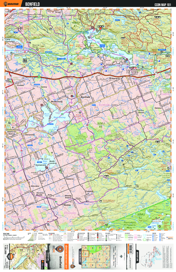
CCON101 Bonfield - Cottage Country Ontario Topo
Backroad Mapbooks
This recreation topographic map for Bonfield highlights all the logging/resource roads, hunting areas, fishing lakes & streams, campsites, paddling routes for canoeing and kayaking, wildlife viewing areas, multi-use trails for hiking, biking, horseback riding, cross-country skiing and snowshoeing, motorized trails for ATVing and snowmobiling & more. Covering 1,090 km2 (420 mi2), this 1:50,000 scale map measures 29 x 38 km (18 x 24 mi), providing you with more topographic and recreational detail for the Richmond Hill area than any other map on the market. New features include enhanced Crown land, countless new roads and trails and a wealth of recreational Points of Interest. Included on this map are Bonfield, Ruthergien, Mattawa River, Algonquin, Provincial, Alderdale, Grand Desert and more!
Page Size: 24 x 37 in (610 x 940 mm)
No search results